Overview
|
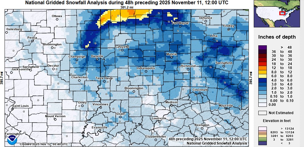
A system along with influence from Lake Michigan brought snow up to a few inches in central Indiana, with much higher totals closer to Lake Michigan. 1.3 inches of snow fell at Indianapolis on November 10, setting a daily record. The city had not recorded so much snow that early in the season since 2.4 inches fell on October 30, 1993. (The total snowfall at Indy was 1.8 inches for November 9-10). |
Snow/Ice
Below are maps of snowfall for this event. Please note that the maps may not match the amounts at your location. A text listing of reports received follow the images. Click any image for a larger version.
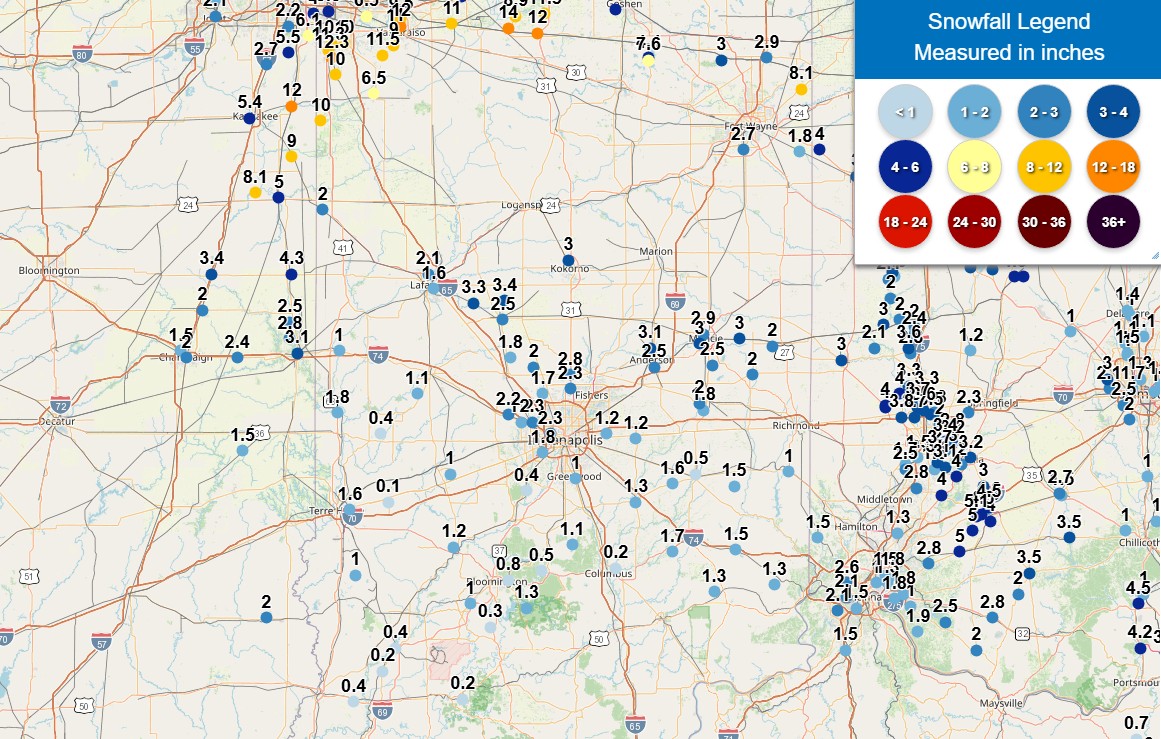
Public Information Statement
National Weather Service Indianapolis IN
1233 PM EST Tue Nov 11 2025

...SNOWFALL REPORTS...

Location                     Amount    Time/Date

...Indiana...

...Bartholomew County...
Hope 5.2 NW                  0.8 in    0800 AM 11/11
Columbus 2 S                 0.1 in    0700 AM 11/11

...Boone County...
Lebanon 4.4 W                2.4 in    0700 AM 11/11
Lebanon 6 W                  2.4 in    0700 AM 11/11
Zionsville 0.5 NNW           1.9 in    0600 AM 11/11

...Brown County...
(W9DBA)Morgantown 6.7 SSE    1.3 in    0600 AM 11/11
Nashville 3.0 WNW            1.1 in    0900 AM 11/11
Nashville 7.8 SE             0.4 in    0630 AM 11/11

...Clay County...
Clay City 0.4 SE             1.0 in    0900 AM 11/11


...Clinton County...
Frankfort 4.9 NNE            3.9 in    0700 AM 11/11
3 W Kirklin                  3.7 in    0700 AM 11/11
Frankfort 0.9 SSE            2.6 in    0700 AM 11/11

...Daviess County...
Plainville 1.3 S             0.5 in    0800 AM 11/11
Elnora 0.1 SW                0.4 in    0800 AM 11/11
Washington 1.5 NW            0.3 in    0700 AM 11/11
Washington 3.3 SE             T in     0700 AM 11/11

...Decatur County...
(KB9CIY)Greensburg 6.0 SW    1.7 in    0700 AM 11/11

...Delaware County...
(K9TKO) Springport 3.6 NE    3.0 in    0700 AM 11/11
(K9CJC) Springport 3.5 NE    2.5 in    0700 AM 11/11
Yorktown 1.1 NNW             2.0 in    0700 AM 11/11
(KC9RVL) Yorktown 1.2 NNW    2.0 in    0700 AM 11/11

...Fountain County...
Covington 0.4 WNW            1.0 in    0700 AM 11/11

...Greene County...
Solsberry 4.0 ESE            1.0 in    0700 AM 11/11
Bloomfield 5.3 ESE           0.7 in    0928 AM 11/11

...Hamilton County...
Westfield 1.4 ESE            3.2 in    0745 AM 11/11
Fishers 6.1 E                3.0 in    0700 AM 11/11
Fishers 4.3 ENE              2.5 in    0700 AM 11/11
Carmel 1.5 W                 2.5 in    0800 AM 11/11
Noblesville 4.4 ESE          2.4 in    0700 AM 11/11
Carmel 1.4 NNE               2.2 in    0700 AM 11/11

...Hancock County...
Cumberland 0.7 E             1.2 in    0700 AM 11/11

...Hendricks County...
Avon 1.6 N                   2.0 in    0700 AM 11/11
Brownsburg 4.6 S             1.7 in    0600 AM 11/11
Avon 1.5 SSE                 1.2 in    0900 AM 11/11
Brownsburg 0.8 NNW           1.2 in    0630 AM 11/11

...Henry County...
New Castle 3.2 W             3.6 in    0700 AM 11/11
New Castle 2.4 SW            3.0 in    0700 AM 11/11

...Howard County...
Russiaville 0.6 WSW          2.0 in    0700 AM 11/11

...Johnson County...
Greenwood 2.1 ESE            1.9 in    0730 AM 11/11
Franklin 1 W                 1.6 in    0700 AM 11/11
Greenwood 3.8 W              1.3 in    0700 AM 11/11
1.8 SE Franklin              0.8 in    0700 AM 11/11
Greenwood 4.9 SW             0.7 in    0700 AM 11/11

...Knox County...
Wheatland 1.4 SSW            0.4 in    0700 AM 11/11
4.0 NE Vincennes University  0.3 in    0800 AM 11/11
Bicknell 0.5 W               0.3 in    0700 AM 11/11

...Lawrence County...
1.7 S Avoca                  0.9 in    0700 AM 11/11
Bedford 8.6 NNW              0.3 in    0730 AM 11/11

...Madison County...
Anderson 4.0 N               3.1 in    0700 AM 11/11

...Marion County...
Speedway 0.3 W               2.3 in    0830 AM 11/11
Indianapolis 3.2 S           2.1 in    0700 AM 11/11
Speedway 6.2 SSW             1.8 in    0700 AM 11/11
McCordsville 1.7 SW          1.4 in    0700 AM 11/11
Indianapolis 7.8 N           1.2 in    0615 AM 11/11
Indianapolis 5.8 NNE         1.2 in    0800 AM 11/11

...Martin County...
Shoals 4.0 E                 1.5 in    0700 AM 11/11

...Monroe County...
Bloomington 1.7 NNW          0.9 in    0700 AM 11/11
Unionville 3.2 NNW           0.8 in    0649 AM 11/11
Bloomington 7.1 E            0.8 in    0800 AM 11/11
Bloomington 2.7 E            0.8 in    0800 AM 11/11
Bloomington 4.3 NW           0.5 in    0700 AM 11/11
Bloomington 6.3 E            0.1 in    0713 AM 11/11

...Montgomery County...
1.1 NW New Market            1.8 in    0600 AM 11/11
New Market 2.6 WNW           1.4 in    0700 AM 11/11

...Morgan County...
Brooklyn 0.5 ENE             1.2 in    0800 AM 11/11
(N9JPX)Paragon 3.2 ENE       0.3 in    0700 AM 11/11
Mooresville 3.8 NE           0.1 in    0700 AM 11/11


...Owen County...
Spencer 7.0 S                1.2 in    0700 AM 11/11
Spencer 5.7 SE               0.9 in    0800 AM 11/11
Ellettsville 5.8 SW          0.5 in    0600 AM 11/11

...Parke County...
Rockville 3.6 ENE            0.4 in    0700 AM 11/11

...Putnam County...
Greencastle 3.6 ESE          1.0 in    0900 AM 11/11
Cloverdale 3.5 W             0.3 in    0830 AM 11/11

...Randolph County...
Modoc 0.1 W                  2.8 in    0700 AM 11/11
(KC9FXU) Winchester 2.2 WSW  2.4 in    0700 AM 11/11
4.6 N Farmland               1.7 in    0800 AM 11/11

...Rush County...
Rushville 0.7 ENE            0.9 in    0600 AM 11/11
Morristown 3.8 ENE           0.8 in    0800 AM 11/11

...Shelby County...
Shelbyville 1.6 SSE          1.3 in    0700 AM 11/11

...Sullivan County...
Hymera 0.4 W                 1.0 in    0800 AM 11/11

...Tippecanoe County...
1 N West Lafayette           2.1 in    0800 AM 11/11
Lafayette 2.2 NE             1.9 in    0700 AM 11/11
Lafayette 0.9 WSW            1.6 in    0800 AM 11/11
Lafayette 2.2 S              1.5 in    0700 AM 11/11
Lafayette 0.5 NNW            1.4 in    0700 AM 11/11
West Lafayette 4.2 NW        1.0 in    0800 AM 11/11

...Tipton County...
Atlanta 4.4 W                2.0 in    0530 AM 11/11
5.1 SE Goldsmith             2.0 in    0530 AM 11/11

...Vermillion County...
0.7 SW Gessie                3.7 in    0600 AM 11/11
Newport 0.4 WSW              1.8 in    0700 AM 11/11

...Vigo County...
Terre Haute 6.5 N            1.8 in    0830 AM 11/11
Terre Haute 2.4 E            1.6 in    0800 AM 11/11
Terre Haute 2.4 ESE          1.6 in    0800 AM 11/11

...Warren County...
0.9 SW Pence                 1.5 in    0700 AM 11/11

Observations are collected from a variety of sources with varying
equipment and exposures. We thank all volunteer weather observers
for their dedication. Not all data listed are considered official.
Environment
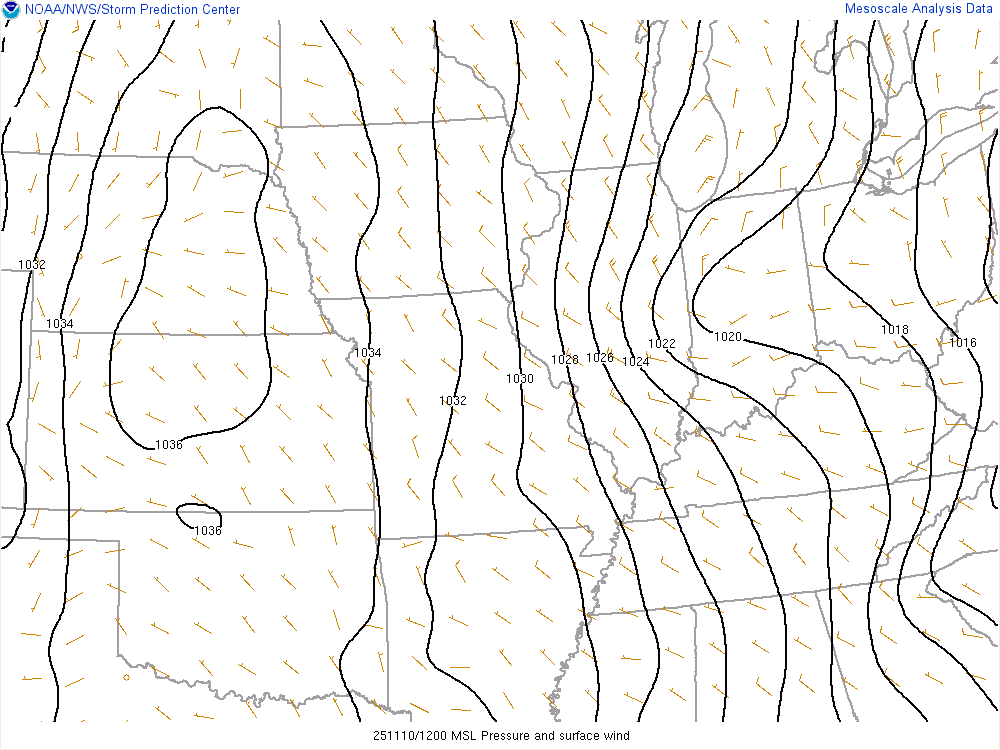
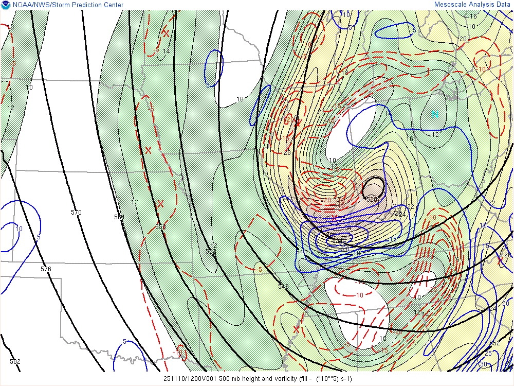
An upper level system along with a surface trough brought snow to the area. Very cold air flowing over Lake Michigan created heavy lake effect snows in far northern Indiana, and effects from the lake enhanced some of the snow as far south as central Indiana.
 |
 |
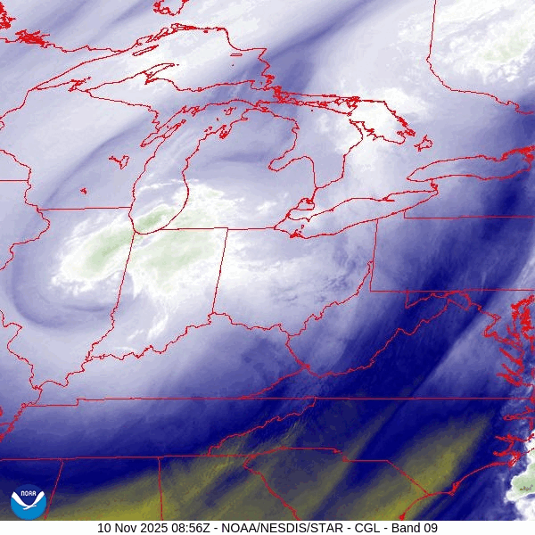 |
| Figure 1: Surface pressure at 7:00 AM EST November 10 | Figure 2: 500mb Heights and mid-level vorticity advection at 7:00 AM EST November 10 | Figure 3: Loop of water vapor satellite images from about 4:00 AM to 8:00 AM November 10. This shows the upper system. |
 |
Media use of NWS Web News Stories is encouraged! Please acknowledge the NWS as the source of any news information accessed from this site. |
|

