Overview
A strong storm system brought damaging non-thunderstorm winds to central Indiana on November 15th. Winds gusted to over 60 mph at some locations, and there many power outages due to the winds. Some trees were downed as well.Wind Speeds
Public Information Statement
National Weather Service Indianapolis IN
943 AM EST Mon Nov 16 2020

...PEAK WIND REPORTS ACROSS CENTRAL INDIANA ON SUNDAY NOVEMBER 15...

Location                     Speed     Time/Date       Provider
Indianapolis                 66 MPH    1140 AM 11/15   ASOS
Muncie                       64 MPH    1023 AM 11/15   ASOS
1.8 SE Whitestown (WEATHERST 56 MPH    0940 AM 11/15   MESOWEST
Westfield                    55 MPH    0942 AM 11/15   CWOP
Greenwood                    55 MPH    1015 AM 11/15   AWOS
W. Lafayette - Purdue Univ.  55 MPH    0247 PM 11/15   ASOS
NEW PALESTINE                54 MPH    1101 AM 11/15   CWOP
Kokomo                       54 MPH    1005 AM 11/15   AWOS
Shelbyville                  53 MPH    1012 AM 11/15   ASOS
Greenfield                   52 MPH    1001 AM 11/15   CWOP
Pendleton                    51 MPH    1047 AM 11/15   CWOP
3.3 N Lewisville (INDOT)     51 MPH    1010 AM 11/15   MESOWEST
Indianapolis (Eagle Creek)   51 MPH    0918 AM 11/15   ASOS
Bloomington                  50 MPH    1209 PM 11/15   CWOP
Edinburgh                    49 MPH    1012 AM 11/15   CWOP
Anderson                     49 MPH    0927 AM 11/15   CWOP
4.7 N Colfax (INDOT)         49 MPH    0940 AM 11/15   MESOWEST
0.8 W Avon (INDOT)           49 MPH    1009 AM 11/15   MESOWEST
Frankfort                    49 MPH    0915 AM 11/15   AWOS
Indianapolis Reg             49 MPH    1115 AM 11/15   AWOS
3 NE Lafayette               48 MPH    1155 PM 11/15   CWOP
Columbus Balkala             48 MPH    1045 AM 11/15   AWOS
Terre Haute                  48 MPH    1249 PM 11/15   ASOS
Indianapolis Exc             48 MPH    0935 AM 11/15   AWOS
0.8 N Cloverdale (INDOT)     47 MPH    1010 AM 11/15   MESOWEST
4.2 S Cortland (INDOT)       47 MPH    1000 AM 11/15   MESOWEST
Bloomington                  47 MPH    0923 AM 11/15   ASOS
I-69 At Scatterfield         46 MPH    1046 AM 11/15   MESOWEST
Crawfordsville               46 MPH    0935 AM 11/15   AWOS
Greencastle                  46 MPH    0215 AM 11/15   AWOS
Kokomo                       45 MPH    0932 AM 11/15   CWOP
Sharpsville                  44 MPH    0945 AM 11/15   CWOP
Greensburg (INDOT)           44 MPH    1050 AM 11/15   MESOWEST
Brownsburg                   43 MPH    1016 AM 11/15   CWOP
Daviess County Airport       43 MPH    0815 AM 11/15   AWOS
Us-31 At Sr-38               42 MPH    0200 PM 11/15   MESOWEST
2.7 N Homecroft (WEATHERSTEM 40 MPH    1050 AM 11/15   MESOWEST
Martinsville                 40 MPH    1153 AM 11/15   CWOP
2 S Fortville                40 MPH    1015 AM 11/15   AWS
Sullivan Raws                40 MPH    0810 AM 11/15   RAWS

Observations are collected from a variety of sources with varying
equipment and exposures. We thank all volunteer weather observers
for their dedication. Not all data listed are considered official.
Storm Reports
PRELIMINARY LOCAL STORM REPORT...SUMMARY
NATIONAL WEATHER SERVICE INDIANAPOLIS IN
910 PM EST SUN NOV 15 2020

..TIME...   ...EVENT...      ...CITY LOCATION...     ...LAT.LON...
..DATE...   ....MAG....      ..COUNTY LOCATION..ST.. ...SOURCE....
            ..REMARKS..

0823 AM     NON-TSTM WND GST 3 SW SEELYVILLE         39.46N 87.31W
11/15/2020  M47 MPH          VIGO               IN   ASOS


0900 AM     NON-TSTM WND DMG 1 E NOBLESVILLE         40.06N 86.01W
11/15/2020                   HAMILTON           IN   PUBLIC

            1.75 INCH DIAMETER ALUMINUM FLAGPOLE
            SNAPPED. ESTIMATED WIND GUST AROUND 50 MPH.

0924 AM     NON-TSTM WND GST 2 N COUNTRY CLUB HEIGHT 40.15N 85.69W
11/15/2020  M48 MPH          MADISON            IN   PUBLIC

            ALSO, 0.2 INCH HAIL FROM 923-926 AM. TWITTER
            REPORT.

0927 AM     NON-TSTM WND GST 3 NNW RIVER FOREST      40.15N 85.75W
11/15/2020  M49 MPH          MADISON            IN   MESONET

            MESONET STATION EW8873 ANDERSON.

0931 AM     NON-TSTM WND GST INDIANAPOLIS INT`L AIRP 39.72N 86.29W
11/15/2020  M51 MPH          MARION             IN   ASOS

            CORRECTS PREVIOUS NON-TSTM WND GST REPORT
            FROM INDIANAPOLIS INT`L AIRPORT.

0941 AM     NON-TSTM WND GST MUNCIE DELAWARE COUNTY  40.24N 85.39W
11/15/2020  E59 MPH          DELAWARE           IN   ASOS

            CORRECTS PREVIOUS NON-TSTM WND GST REPORT
            FROM MUNCIE DELAWARE COUNTY AIRPORT.

0942 AM     NON-TSTM WND GST 4 SW WESTFIELD          40.01N 86.18W
11/15/2020  M55 MPH          HAMILTON           IN   MESONET

            MESONET STATION DW3869 WESTFIELD.

0952 AM     NON-TSTM WND GST 3 ESE FAIRLAND          39.59N 85.81W
11/15/2020  M52 MPH          SHELBY             IN   ASOS


1001 AM     NON-TSTM WND GST 2 SSE NEW PALESTINE     39.70N 85.88W
11/15/2020  M51 MPH          SHELBY             IN   MESONET

            MESONET STATION AV182 NEW PALESTINE.

1012 AM     NON-TSTM WND GST 4 W FLAT ROCK           39.37N 85.90W
11/15/2020  M49 MPH          SHELBY             IN   MESONET

            MESONET STATION EW1771 EDINBURGH.

1013 AM     NON-TSTM WND DMG 4 E FISHERS             39.98N 85.95W
11/15/2020                   HAMILTON           IN   PUBLIC

            GUST OF 45 MPH.

1015 AM     NON-TSTM WND GST 2 WNW PENDLETON         40.01N 85.77W
11/15/2020  M49 MPH          MADISON            IN   MESONET

            MESONET STATION AU584 PENDLETON.

1016 AM     NON-TSTM WND GST 2 SSE NEW PALESTINE     39.70N 85.88W
11/15/2020  M54 MPH          SHELBY             IN   MESONET

            MESONET STATION AV182 NEW PALESTINE.

1022 AM     HEAVY RAIN       4 SW WESTFIELD          40.01N 86.18W
11/15/2020  M1.76 INCH       HAMILTON           IN   MESONET

            MESONET STATION DW3869 WESTFIELD.

1023 AM     NON-TSTM WND GST 3 NNE BALL STATE UNIVER 40.23N 85.40W
11/15/2020  M64 MPH          DELAWARE           IN   ASOS

            ASOS STATION KMIE MUNCIE.

1045 AM     NON-TSTM WND GST 2 SW CLIFFORD           39.27N 85.90W
11/15/2020  M48 MPH          BARTHOLOMEW        IN   AWOS

            AWOS STATION KBAK COLUMBUS BALKALA.

1145 AM     NON-TSTM WND DMG GREENSBURG              39.34N 85.48W
11/15/2020                   DECATUR            IN   EMERGENCY MNGR

            MULTIPLE TREES AND POWER LINES DOWN IN THE
            COUNTY. SOME ROADS BLOCKED BUT MOST ARE
            BEING CLEARED. SOME STOP LIGHTS IN
            GREENSBURG ON MAIN STREET ARE NOT
            FUNCTIONING.

1201 PM     NON-TSTM WND DMG BROAD RIPPLE            39.87N 86.14W
11/15/2020                   MARION             IN   PUBLIC

            CORRECTS PREVIOUS WND DMG REPORT FROM BROAD
            RIPPLE. TREE LIMBS DOWN.

0156 PM     NON-TSTM WND DMG 1 NW NORTH TERRE HAUTE  39.55N 87.37W
11/15/2020                   VIGO               IN   AMATEUR RADIO

            30 INCH DIAMETER TREE DOWNED ON ROSE HILL
            AVENUE.
Environment
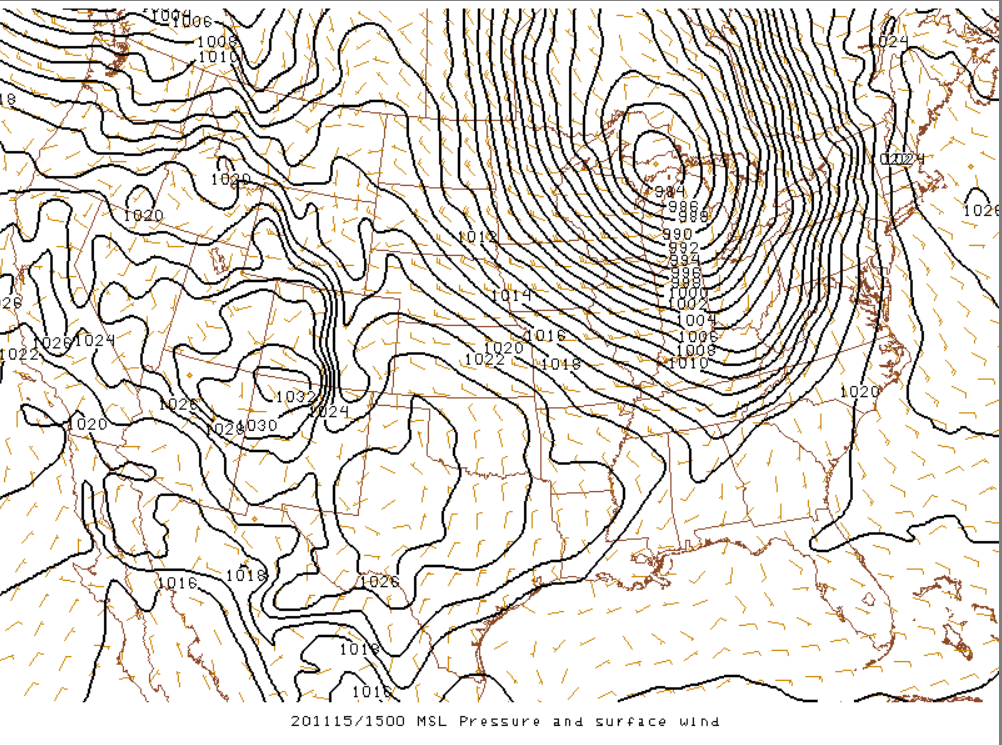
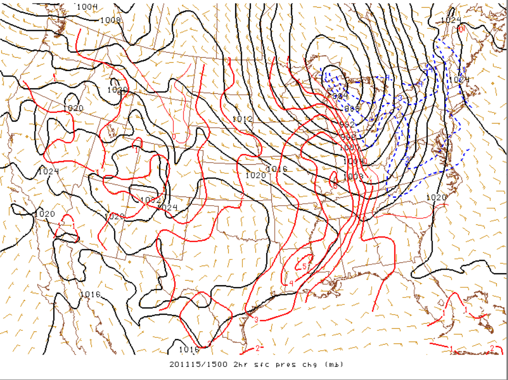
A strong surface low pressure system brought strong to occasionally damaging winds to central Indiana. A tight pressure gradient and strong winds mixing down from higher up in the atmosphere contributed to the strong winds.
 |
 |
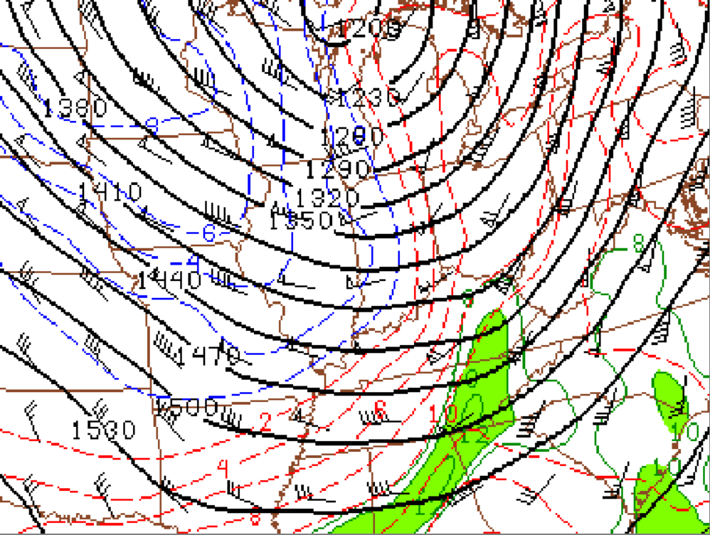 |
| Figure 1: Surface pressure at 10 AM EST | Figure 2: 2 hour surface pressure change at 10 AM EST | Figure 3: 850mb analysis at 10 AM EST, showing stronger winds aloft |
 |
Media use of NWS Web News Stories is encouraged! Please acknowledge the NWS as the source of any news information accessed from this site. |
|

