Overview
A strong low pressure system brought severe thunderstorms, a tornado, and even damaging winds outside of thunderstorms on March 14, 2019.Tornadoes:
|
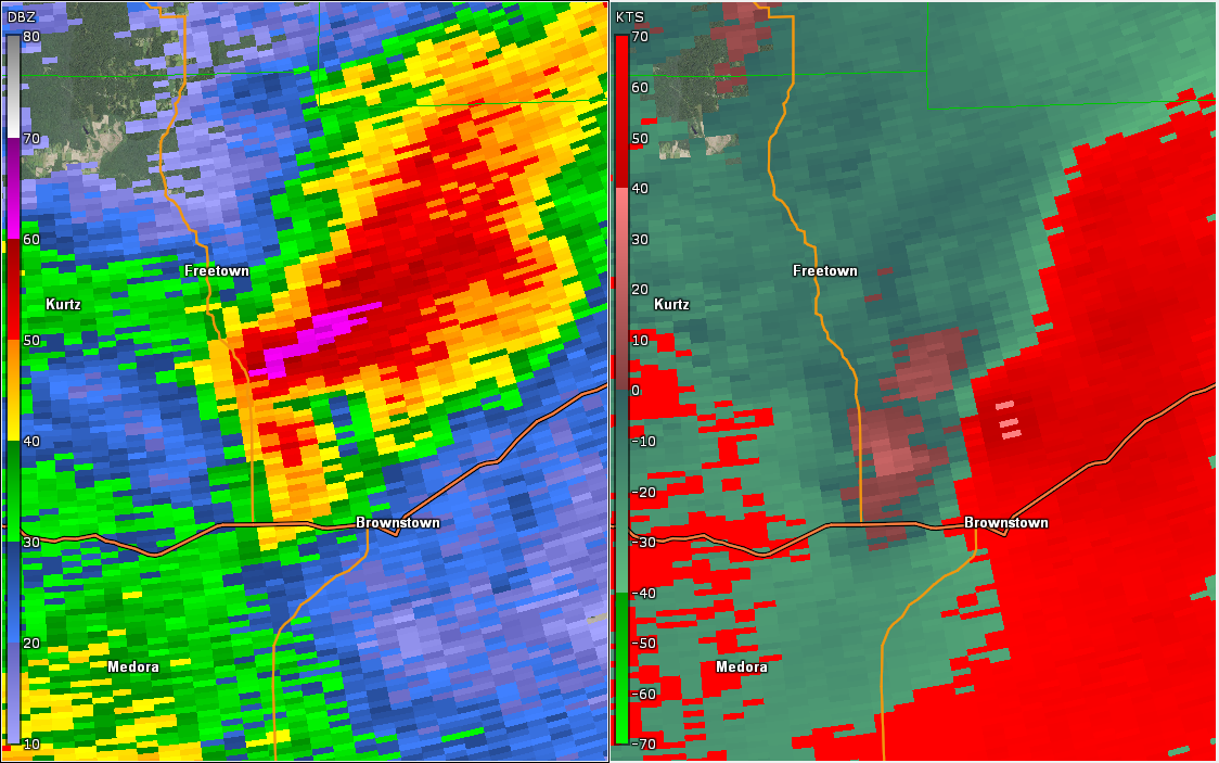
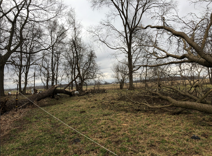
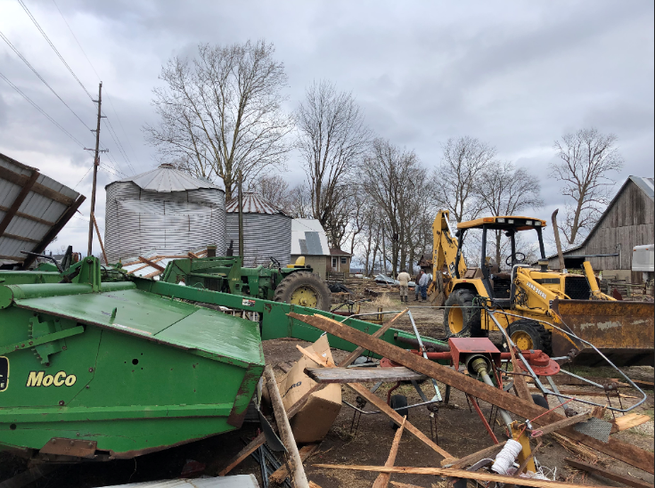
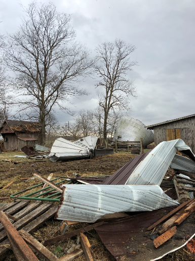
Tornado - Near Brownstown
Track Map 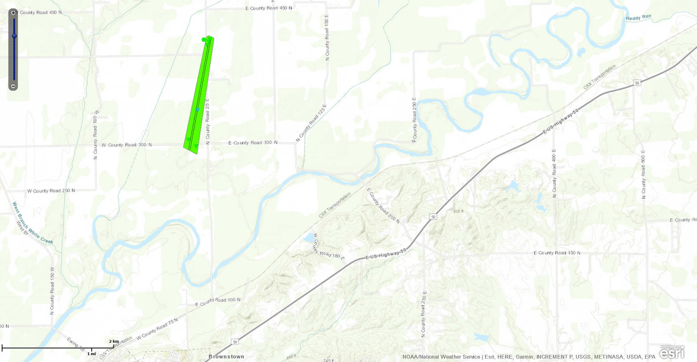 
|
||||||||||||||||
|
||||||||||||||||
The Enhanced Fujita (EF) Scale classifies tornadoes into the following categories:
| EF0 Weak 65-85 mph |
EF1 Moderate 86-110 mph |
EF2 Significant 111-135 mph |
EF3 Severe 136-165 mph |
EF4 Extreme 166-200 mph |
EF5 Catastrophic 200+ mph |
 |
|||||
Winds
The strong low pressure system created damaging winds even outside of thunderstorms. Below are some of the higher peak wind gusts measured.
Public Information Statement
National Weather Service Indianapolis IN
148 AM EDT Fri Mar 15 2019

...HIGHEST WIND REPORTS FOR THE PAST 12 HOURS...

Location                     Speed     Time/Date       Provider
Indianapolis, In             60 MPH    0615 PM 03/14   ASOS
2 NNW Terre Haute            59 MPH    1214 AM 03/15   CWOP
2 NW Crows Nest              58 MPH    0510 PM 03/14   CWOP
Hulman Regional Airport      57 MPH    0516 PM 03/14   ASOS
1 ENE Bloomington            56 MPH    0541 PM 03/14   CWOP
Daviess County Airport       53 MPH    0435 PM 03/14   AWOS
Eagle Creek Airpark Airport  53 MPH    0520 PM 03/14   ASOS
Monroe County Airport        52 MPH    0631 PM 03/14   ASOS
2 NNW Lake Hart              52 MPH    0503 PM 03/14   CWOP
2 E Shepardsville            51 MPH    0355 PM 03/14   CWOP
Frankfort                    51 MPH    0515 PM 03/14   AWOS
5 NNE Zionsville             51 MPH    0534 PM 03/14   NONFEDAWOS
Indianapolis Terry Airport   51 MPH    0535 PM 03/14   AWOS
2 NE Plainfield              50 MPH    0446 PM 03/14   CWOP
W. Lafayette - Purdue Univ.  50 MPH    1051 PM 03/14   ASOS
1 ENE Greenwood              48 MPH    0655 PM 03/14   MESOWEST
4 SSE Mccordsville           48 MPH    0635 PM 03/14   NONFEDAWOS
Mt Comfort Airport           48 MPH    0635 PM 03/14   AWOS
Kokomo Municipal Airport     48 MPH    0606 PM 03/14   AWOS
3 ENE Edinburgh              47 MPH    0701 PM 03/14   CWOP
Fairview Park                47 MPH    0231 PM 03/14   CWOP
Shelbyville Municipal Airpor 48 MPH    0613 PM 03/14   ASOS
1 N New Market               47 MPH    0355 PM 03/14   MESOWEST
Delaware County-johnson Fiel 47 MPH    0519 PM 03/14   ASOS
Columbus Municipal Airport   46 MPH    0750 PM 03/14   AWOS

Observations are collected from a variety of sources with varying
equipment and exposures. We thank all volunteer weather observers
for their dedication. Not all data listed are considered official.
Radar
| Radar Loop |
Storm Reports
Below are some of the hail and wind damage reports received during this event.
PRELIMINARY LOCAL STORM REPORT
NATIONAL WEATHER SERVICE INDIANAPOLIS IN


..TIME...   ...EVENT...      ...CITY LOCATION...     ...LAT.LON...
..DATE...   ....MAG....      ..COUNTY LOCATION..ST.. ...SOURCE....
            ..REMARKS..

1247 PM     HAIL             RUSSIAVILLE             40.42N 86.27W
03/14/2019  E0.88 INCH       HOWARD             IN   TRAINED SPOTTER

0225 PM     HAIL             BROWNSTOWN              38.88N 86.05W
03/14/2019  M1.00 INCH       JACKSON            IN   PUBLIC

            RELAYED VIA SOCIAL MEDIA.


0245 PM     HAIL             2 S JONESVILLE          39.03N 85.89W
03/14/2019  E0.70 INCH       JACKSON            IN   PUBLIC

            SPOTTER REPORTS 0.5 INCH HAIL AND A WALL
            CLOUD.

0329 PM     NON-TSTM WND DMG ROCKVILLE               39.77N 87.23W
03/14/2019                   PARKE              IN   TRAINED SPOTTER

            SPOTTER ESTIMATES 60 MPH WINDS. REPORTS
            TELEPHONE POLES KNOCKED DOWN.

0430 PM     NON-TSTM WND DMG VINCENNES               38.68N 87.51W
03/14/2019                   KNOX               IN   EMERGENCY MNGR

            TREES AND UTILITY LINES DOWNED BY GRADIENT
            WINDS AT VARIOUS LOCATIONS AROUND KNOX
            COUNTY.


0545 PM     NON-TSTM WND DMG 2 S BROWNSBURG          39.81N 86.39W
03/14/2019                   HENDRICKS          IN   PUBLIC

            REPORTS OF SMALL TREES DOWN ALONG WALKING
            TRAIL.
Environment
| Figure 1: Loop of Surface Pressure and Winds | Figure 2: Loop of Surface CAPE |
| Figure 3: Loop of 850mb Height & Wind | Figure 4: Loop of 500mb Height & Wind |
 |
Media use of NWS Web News Stories is encouraged! Please acknowledge the NWS as the source of any news information accessed from this site. |
|