Overview
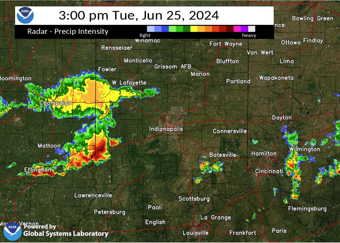
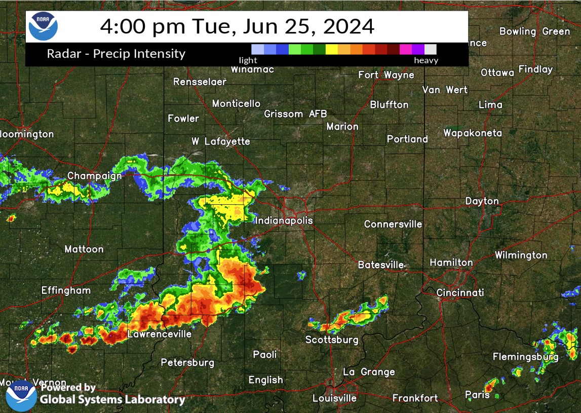
Thunderstorms brought widespread tree and powerline damage to portions of central Indiana during the afternoon of June 25, 2024. Over 60,000 people were without power after the storms. Winds gusted over 70 mph at some locations.Radar
Selected images from the event are below. A loop of radar from the event follows the images below..
 |
 |
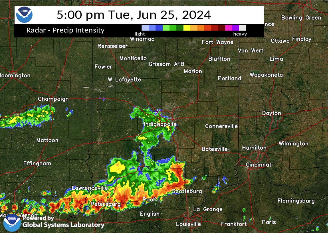 |
| Radar at 3:00 PM EDT | Radar at 4:00 PM EDT | Radar at 5:00 PM EDT |
Storm Reports
Preliminary Local Storm Report...Summary
National Weather Service Indianapolis IN
123 PM EDT Wed Jun 26 2024

..TIME...   ...EVENT...      ...CITY LOCATION...     ...LAT.LON...
..DATE...   ....MAG....      ..COUNTY LOCATION..ST.. ...SOURCE....
            ..REMARKS..

0250 PM     Tstm Wnd Dmg     Prairie Creek           39.31N 87.53W
06/25/2024                   Vigo               IN   Trained Spotter

            Small branches off trees and pea size hail.

0300 PM     Tstm Wnd Dmg     4 S Indiana State Unive 39.41N 87.41W
06/25/2024                   Vigo               IN   Trained Spotter

            A tree was blown down by thunderstorm winds
            and is blocking Raymond Drive. Time is
            approximate.

0300 PM     Tstm Wnd Dmg     2 SW Riley              39.36N 87.33W
06/25/2024                   Vigo               IN   Trained Spotter

            Several full grown trees and a flag pole
            have been blown down by thunderstorm winds.

0300 PM     Tstm Wnd Dmg     2 SSE West Terre Haute  39.44N 87.43W
06/25/2024                   Vigo               IN   Trained Spotter

            A large branch was sheared off a a large
            tree and a large sign in a parking lot near
            the road edge was blown down as a result of
            thunderstorm winds. Time is approximate.

0300 PM     Tstm Wnd Dmg     4 S Indiana State Unive 39.41N 87.41W
06/25/2024                   Vigo               IN   Trained Spotter

            A small tree was uprooted and another tree
            split by thunderstorm winds. Time is
            approximate.

0300 PM     Tstm Wnd Dmg     4 SSE Indiana State Uni 39.41N 87.39W
06/25/2024                   Vigo               IN   Trained Spotter

            Thunderstorm winds blew down a tree that is
            blocking Cherrywood Street.

0302 PM     Tstm Wnd Dmg     4 NE Prairieton         39.41N 87.43W
06/25/2024                   Vigo               IN   Trained Spotter

            Thunderstorm winds have blown off one or
            more of the following...roof shingles,
            branches, awnings, fences, and carports onto
            cars.

0304 PM     Tstm Wnd Dmg     5 W Clay City           39.27N 87.21W
06/25/2024                   Clay               IN   911 Call Center

            Trees and Powerlines Down East of Lewis
            Township.

0304 PM     Tstm Wnd Gst     4 SW Seelyville         39.45N 87.31W
06/25/2024  M59 MPH          Vigo               IN   ASOS

            Preliminary max gust.

0307 PM     Tstm Wnd Dmg     1 NE Clay City          39.28N 87.10W
06/25/2024                   Clay               IN   Public

            Delayed Report. Strong sustained wind gusts
            knocked over corn crop and snapped large old
            growth trees over plus several large limbs
            of others landing on power lines with enough
            force to snap the cables. 1 tree landed
            across a lane of IN SR 246. Neighbors grain
            bin tower was crumpled.

0327 PM     Tstm Wnd Dmg     1 W Spencer             39.29N 86.79W
06/25/2024                   Owen               IN   Emergency Mngr

            Delayed report. Trees down west of Spencer.
            Time estimated by radar.

0352 PM     Hail             Crothersville           38.80N 85.84W
06/25/2024  M1.00 Inch       Jackson            IN   Public

            Report from mPING...quarter size hail.

0355 PM     Tstm Wnd Gst     1 SE Bloomington        39.15N 86.50W
06/25/2024  M60 MPH          Monroe             IN   Trained Spotter


0400 PM     Tstm Wnd Dmg     4 WSW West Terre Haute  39.43N 87.52W
06/25/2024                   Vigo               IN   Trained Spotter

            A roof was blown off a garage near the
            intersection of Robinson Road and Kiewig
            Drive by thunderstorm winds.

0402 PM     Tstm Wnd Gst     1 SE Bloomington        39.15N 86.50W
06/25/2024  M70 MPH          Monroe             IN   Trained Spotter

            Tree branches of unknown size were blown
            down by thunderstorm winds.

0405 PM     Tstm Wnd Dmg     Bicknell                38.77N 87.31W
06/25/2024                   Knox               IN   Emergency Mngr

            A tree was blown down by thunderstorm winds
            at 3rd street and Alexander.

0405 PM     Tstm Wnd Dmg     Bruceville              38.76N 87.41W
06/25/2024                   Knox               IN   Emergency Mngr

            A tree and utility lines were downed by
            thunderstorm winds at State Rd 550 near Vine
            Street.

0405 PM     Tstm Wnd Dmg     1 SW Whitehall          39.16N 86.59W
06/25/2024                   Monroe             IN   Trained Spotter

            A 2.5-inch diameter healthy tree split due
            to thunderstorm winds. Time approximated.

0405 PM     Tstm Wnd Dmg     Vincennes University    38.68N 87.52W
06/25/2024                   Knox               IN   Emergency Mngr

            A utility line was blown down by
            thunderstorm winds near 6th Street and
            Sycamore Street.

0405 PM     Tstm Wnd Dmg     2 ESE Bloomington       39.15N 86.48W
06/25/2024                   Monroe             IN   Trained Spotter

            Eight-inch tree branches were blown down by
            thunderstorm winds near the intersection of
            South Olcott Boulevard and East Moores Pike.
            Pea-size hail accompanied the winds. Power
            is out.

0406 PM     Tstm Wnd Dmg     3 E Bloomington         39.16N 86.47W
06/25/2024                   Monroe             IN   Public

            A tree and tree limbs were blown down by
            thunderstorm winds. Details are unavailable
            due to amateur radio conditions.

0406 PM     Tstm Wnd Gst     5 WSW Whitehall         39.14N 86.65W
06/25/2024  E70 MPH          Monroe             IN   Public

            Three-inch diameter branches were blown down
            by thunderstorm winds.

0412 PM     Tstm Wnd Gst     3 SW Whitehall          39.15N 86.62W
06/25/2024  M78 MPH          Monroe             IN   ASOS

            Peak wind speed is preliminary.

0430 PM     Tstm Wnd Dmg     3 SSW Charles Deam Wild 39.00N 86.38W
06/25/2024                   Monroe             IN   Emergency Mngr

            Delayed report. Time estimated by radar.
            Multiple large trees and power lines down in
            southeast part of the county. Roads are
            blocked.

0433 PM     Tstm Wnd Gst     Spurgeons Corner        39.07N 86.15W
06/25/2024  M75 MPH          Brown              IN   Public

            Delayed Report. Numerous trees downed.

0500 PM     Non-Tstm Wnd Dmg 2 NW Crows Nest         39.87N 86.20W
06/25/2024                   Marion             IN   Amateur Radio

            Delayed report. 30 inch diameter tree on
            house at 64th and Knollton. From
            non-thunderstorm mesoscale wind event. Time
            estimated.

0500 PM     Non-Tstm Wnd Dmg Zionsville              39.95N 86.26W
06/25/2024                   Boone              IN   Emergency Mngr

            Delayed report. Large tree uprooted at 3rd
            and Linden. From mesoscale non-thunderstorm
            wind event. Time estimated.
Environment
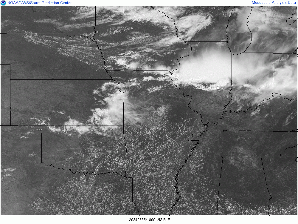
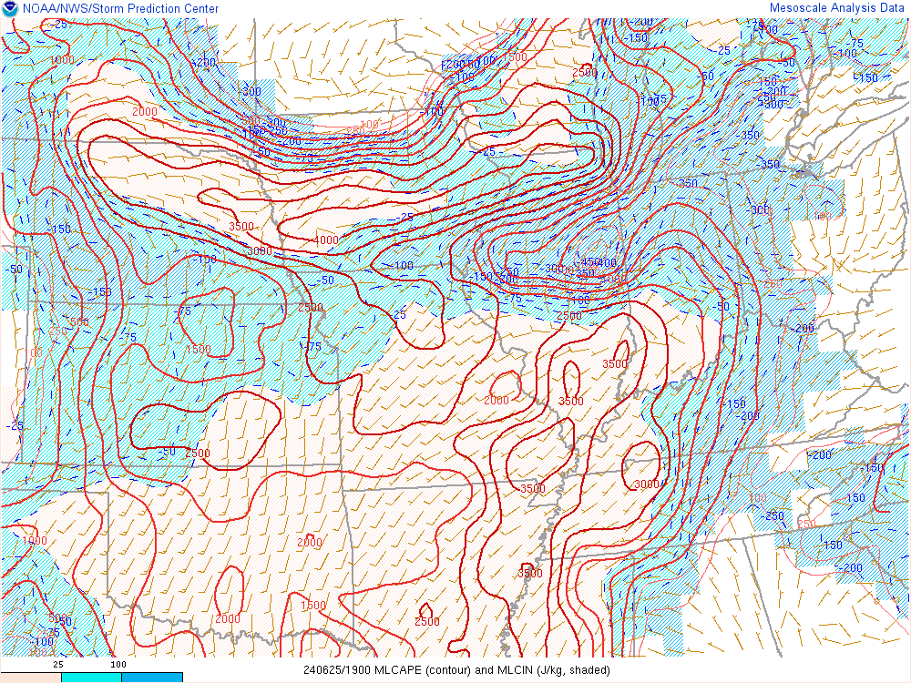
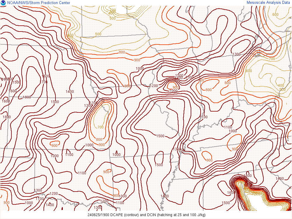
Clouds diminished and allowed instability to build across southern portions of central Indiana during the afternoon. The storms also had an old outflow boundary to work with as they moved into the area.
 |
 |
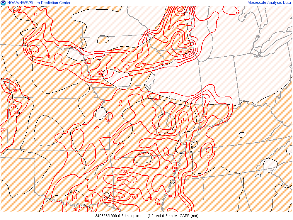 |
| Figure 1: Visible Satellite Image at 2:00 PM EDT | Figure 2: Mixed Layer CAPE at 3:00 PM EDT | Figure 3: 0-3km Lapse Rate and Low Level CAPE at 3:00 PM EDT |
 |
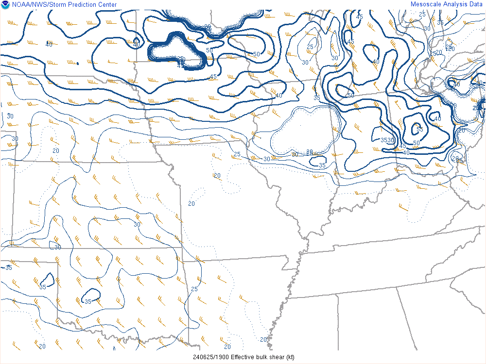 |
| Figure 4: Downdraft CAPE at 3:00 PM EDT | Figure 5: Effective Shear at 3:00 PM EDT |
 |
Media use of NWS Web News Stories is encouraged! Please acknowledge the NWS as the source of any news information accessed from this site. |
|

