Overview
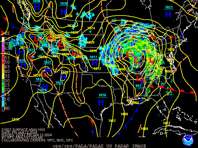
A strong area of low pressure moved across central Indiana on January 12, bringing widespread rain, strong winds, and some snow. Winds knocked down trees and power lines in eastern portions of central Indiana. This was the second strong low pressure system to pass within a week. The record low pressure for January at Indianapolis was set with the previous low. These systems brought much needed rainfall, with combined rainfall totals of 2 to over 3 inches common.Winds/Pressure
Public Information Statement
National Weather Service Indianapolis IN
757 AM EST Sat Jan 13 2024

...PEAK WIND GUSTS JAN 12TH/700A -to- JAN 13TH/700A...
...LOWEST SEA LEVEL PRESSURE on both 1/9/24 and 1/12/24...


I. PEAK WIND GUSTS JANUARY 12TH/700A -to- JANUARY 13TH/700A...

LOCATION       COUNTY      Speed  Date/Time  Elev  Source

Shelbyville    Shelby      61 MPH  12/0807A   802  ASOS
Kokomo         Howard      51 MPH  12/1245A   823  AWOS
Lafayette      Tippecanoe  48 MPH  12/1036P   609  ASOS
Columbus       Bartholomew 48 MPH  12/0845A   652  AWOS
Indianapolis   Marion      47 MPH  13/1242A   776  ASOS
Muncie         Delaware    47 MPH  13/0515A   934  ASOS
Frankfort      Clinton     47 MPH  13/1215A   856  AWOS
Crawfordsville Montgomery  46 MPH  12/0935P   801  AWOS
Bloomington    Monroe      46 MPH  12/1128P   844  ASOS
Edinburgh      Shelby      45 MPH  12/0738A   794  Mesonet
Bedford        Lawrence    45 MPH  12/0515P   731  AWOS
-------------------------------------------------------------
New Palestine  Hancock     44 MPH  13/0100A   787  Mesonet
Terre Haute    Vigo        43 MPH  12/0951P   582  ASOS
Lafayette 8 S  Tippecanoe  42 MPH  13/0100A   734  Meosnet
Sullivan       Sullivan    41 MPH  13/1210A   530  RAWS
Mitchell       Lawrence    41 MPH  12/0709A   652  Mesonet
Winchester     Randolph    40 MPH  13/0516A  1160  Mesonet
New Richmond   Montgomery  40 MPH  12/1105P   768  Mesonet
Eagle Creek AP Marion      40 MPH  13/0222A   788  ASOS
Washington     Daviess     40 MPH  12/1035P   466  AWOS
Zionsville     Boone       40 MPH  13/0235A   917  AWOS


II. LOWEST RECORDED SEA LEVEL PRESSURE on 1/9/24 and 1/12/24...

AIRPORT ASOS   1/9/2024 Min SLP, Time  |  1/12/2024 Min SLP, Time

Indianapolis  28.97 in./ 981 mb, 421P  |  29.08 in./ 985 mb, 430P
Lafayette     28.96 in./ 981 mb, 330P  |  29.08 in./ 985 mb, 240P
Terre Haute   29.00 in./ 982 mb, 300P  |  29.09 in./ 985 mb, 255P
Bloomington   29.01 in./ 982 mb, 330P  |  29.07 in./ 984 mb, 345P
Muncie        28.92 in./ 979 mb, 323P  |  29.06 in./ 984 mb, 530P
Shelbyville   28.98 in./ 981 mb, 215P  |  29.07 in./ 984 mb, 440P
Eagle Creek   28.97 in./ 981 mb, 420P  |  29.08 in./ 985 mb, 430P


Observations are collected from a variety of sources with varying
equipment and exposures. We thank all volunteer weather observers
for their dedication. Not all data listed are considered official.
Storm Reports
Preliminary Local Storm Report...Summary
National Weather Service Indianapolis IN


..TIME...   ...EVENT...      ...CITY LOCATION...     ...LAT.LON...
..DATE...   ....MAG....      ..COUNTY LOCATION..ST.. ...SOURCE....
            ..REMARKS..

0900 AM     Non-Tstm Wnd Dmg 1 WSW Seymour           38.95N 85.91W
01/12/2024                   Jackson            IN   Emergency Mngr

            Tree fell into house, Trees into power lines
            and flat roof blown off of building.

1007 AM     Non-Tstm Wnd Dmg 1 WNW Greensburg        39.35N 85.49W
01/12/2024                   Decatur            IN   Emergency Mngr

            Dozens of trees and power poles down across
            Decatur County.

1051 AM     Non-Tstm Wnd Dmg 1 WSW Milroy            39.49N 85.49W
01/12/2024                   Rush               IN   Emergency Mngr

            Many trees down throughout Rush County with
            most being in the south to southwest
            portion. Rush and Shelby counties are
            reporting power outages in the southeastern
            part of the county.

1223 PM     Non-Tstm Wnd Dmg 1 NW Winchester         40.19N 84.99W
01/12/2024                   Randolph           IN   Amateur Radio

            Reports of multiple trees down across
            Randolph Co.

0630 PM     Non-Tstm Wnd Dmg 1 NNE Newpoint          39.32N 85.33W
01/12/2024                   Decatur            IN   Amateur Radio

            Power outages reported for over an hour due
            to high winds.
Environment
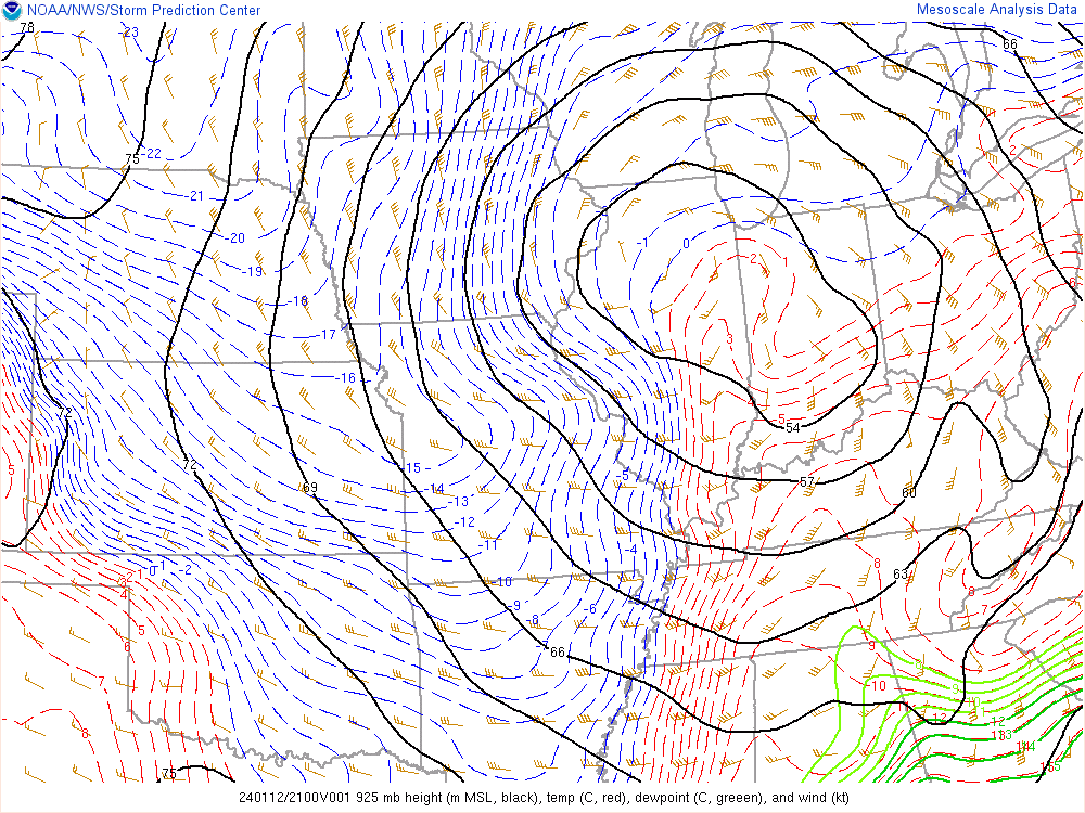
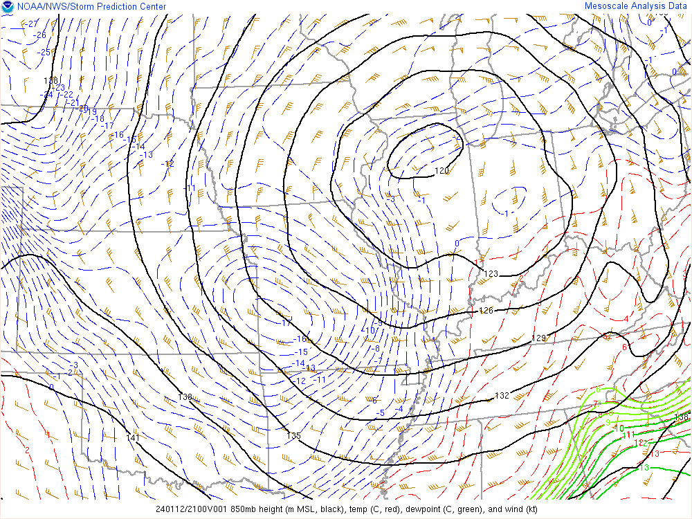
In addition to the low pressure at the surface, winds were very strong aloft. Some of these winds mixed down, causing the damage.
 |
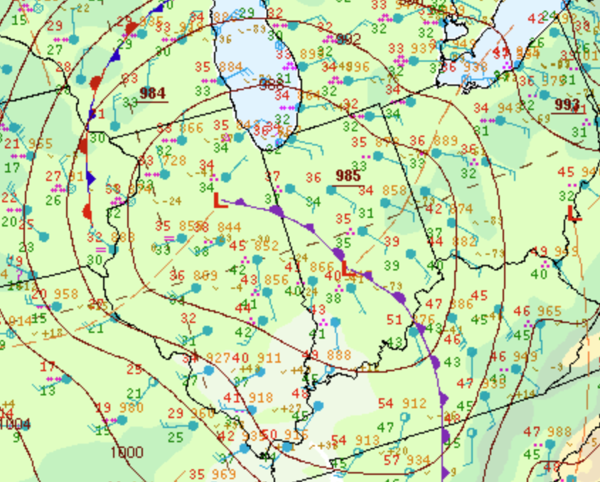 |
| Figure 1: Surface Map/Radar at 4 PM EST | Figure 2: Zoomed in Surface Map at 4 PM EST |
 |
 |
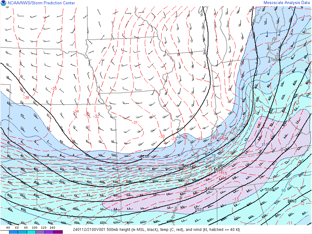 |
| Figure 3: 925mb Analysis at 4 PM EST | Figure 4: 850mb Analysis at 4 PM EST | Figure 5: 500mb Analysis at 4 PM EST |
 |
Media use of NWS Web News Stories is encouraged! Please acknowledge the NWS as the source of any news information accessed from this site. |
 |