Overview
Thunderstorms developed ahead of an area of strong low pressure and a cold front. These storms brought damaging winds and a couple of tornadoes. The strong low pressure also brought wind gusts over 50 mph outside of thunderstorms.Tornadoes
|
Tornado - SE of McCordsville
Track Map 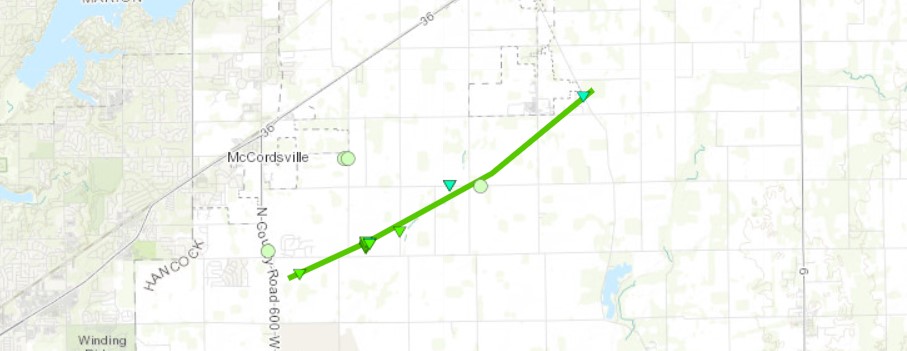 
|
||||||||||||||||
|
||||||||||||||||
|
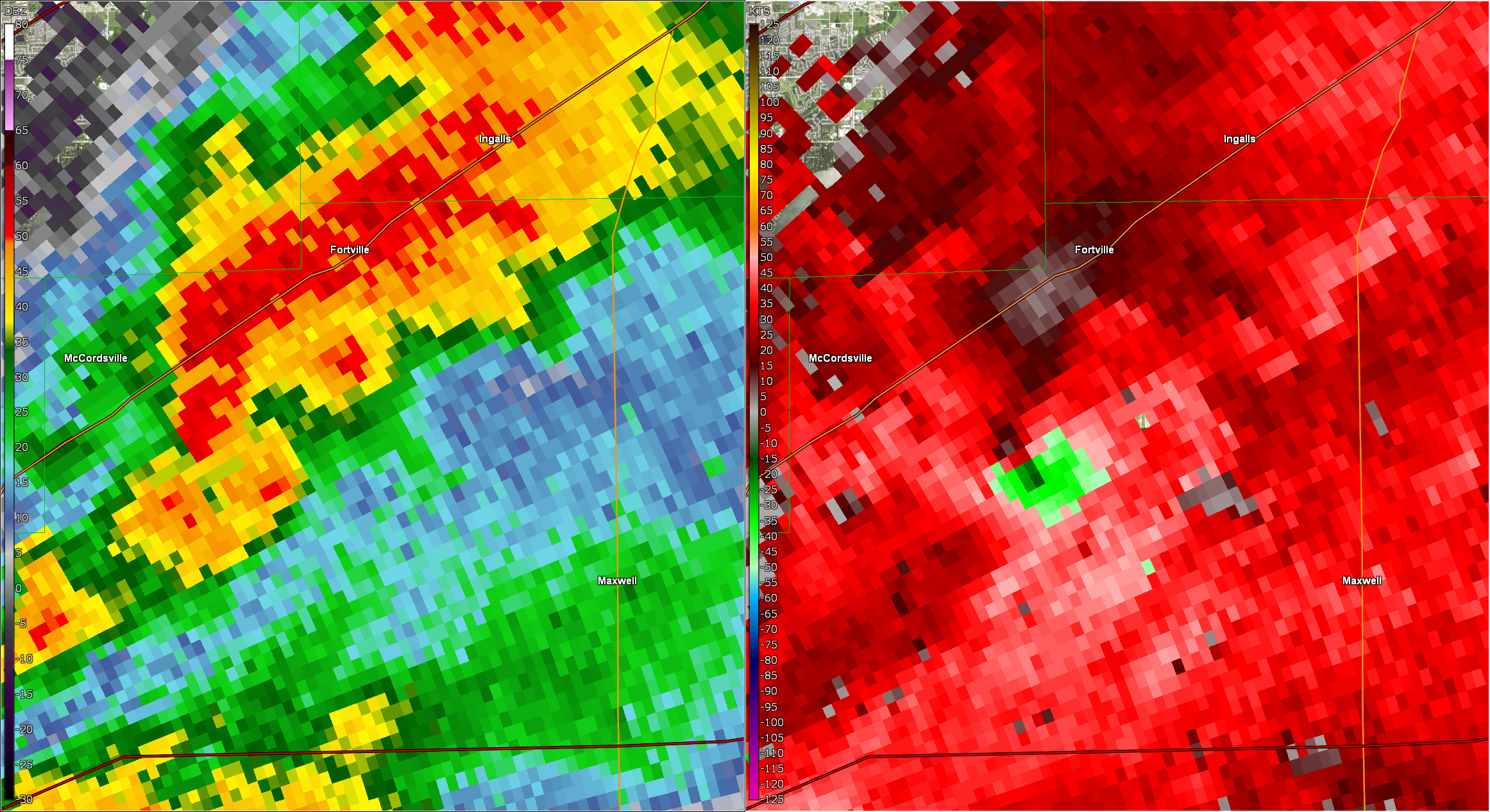
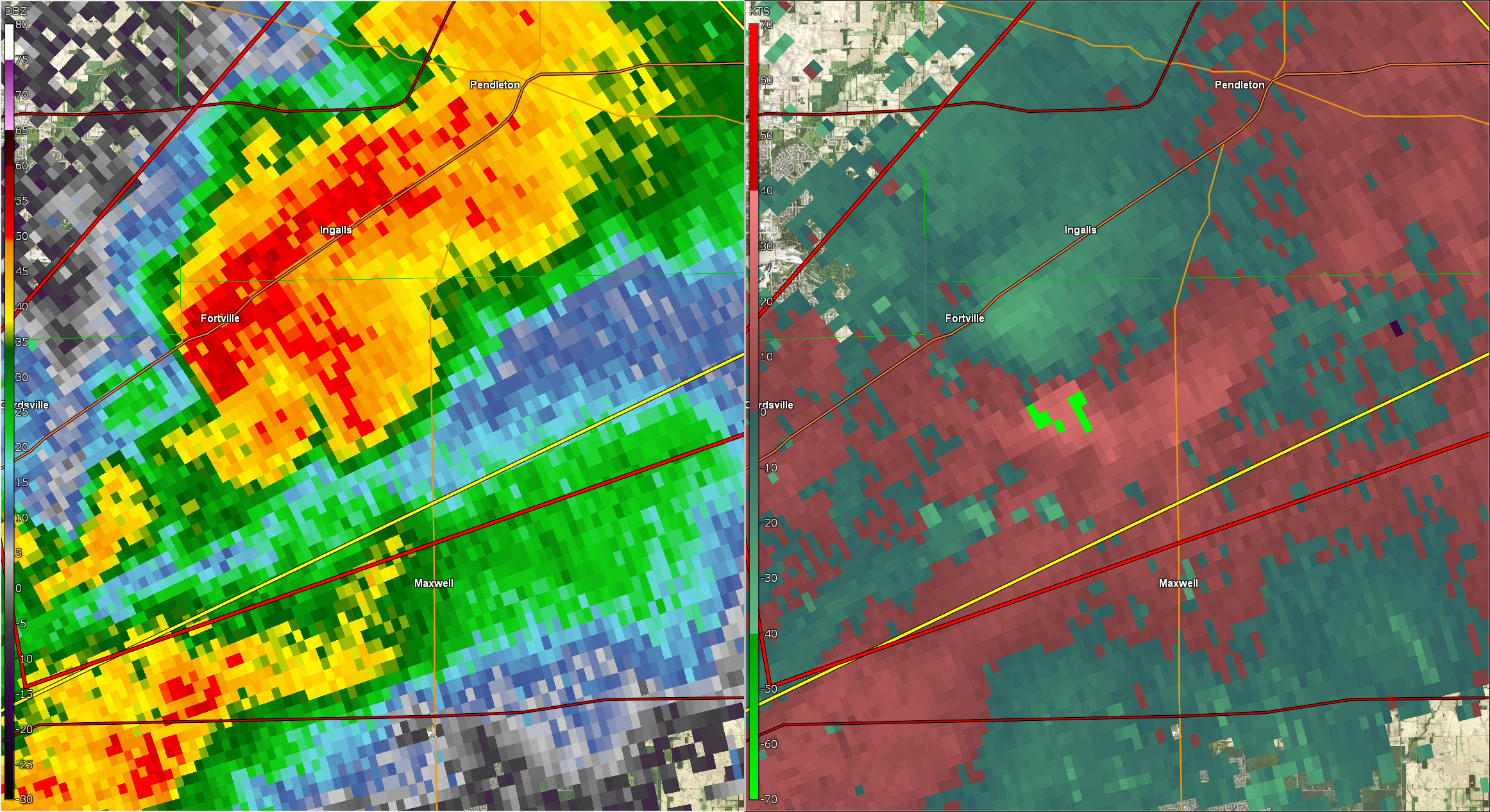
Tornado - Near Ingalls
Track Map 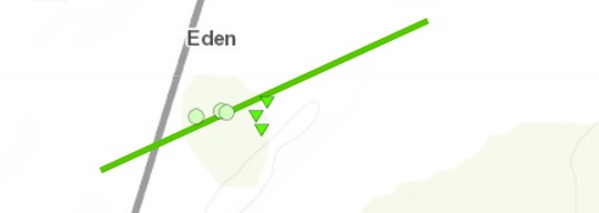
|
||||||||||||||||
|
||||||||||||||||
The Enhanced Fujita (EF) Scale classifies tornadoes into the following categories:
| EF0 Weak 65-85 mph |
EF1 Moderate 86-110 mph |
EF2 Significant 111-135 mph |
EF3 Severe 136-165 mph |
EF4 Extreme 166-200 mph |
EF5 Catastrophic 200+ mph |
 |
|||||
Storm Reports
PRELIMINARY LOCAL STORM REPORT
NATIONAL WEATHER SERVICE INDIANAPOLIS IN

1121 AM     NON-TSTM WND GST 3 SW WHITEHALL          39.15N 86.62W
02/27/2023  M55 MPH          MONROE             IN   ASOS

1229 PM     NON-TSTM WND GST 4 SW SEELYVILLE         39.45N 87.31W
02/27/2023  M58 MPH          VIGO               IN   ASOS


1242 PM     TSTM WND GST     KINGMAN                 39.97N 87.28W
02/27/2023  E55 MPH          FOUNTAIN           IN   TRAINED SPOTTER

            WIND GUSTS STRONG ENOUGH THAT THEY SHOOK A
            MOBILE HOME. SPEED ESTIMATED.

0121 PM     TSTM WND DMG     OAKTOWN                 38.87N 87.44W
02/27/2023                   KNOX               IN   PUBLIC

            REPORT FROM MPING: 1-INCH TREE LIMBS BROKEN;
            SHINGLES BLOWN OFF.

0121 PM     HAIL             LAWRENCE                39.87N 85.99W
02/27/2023  E0.70 INCH       MARION             IN   PUBLIC

0125 PM     TSTM WND DMG     3 SE MCCORDSVILLE       39.87N 85.90W
02/27/2023                   HANCOCK            IN   PUBLIC

            POWER LINES SHEARED. TWITTER POST AND
            PICTURES. TIME AND DURATION ESTIMATED.

0128 PM     TORNADO          3 SSE MCCORDSVILLE      39.87N 85.91W
02/27/2023                   HANCOCK            IN   NWS STORM SURVEY

            LATE REPORT OF EF-1 TORNADO WITH ESTIMATED
            110 MPH PEAK WINDS. 3.34 MILE LONG TRACK. 50
            YARDS MAXIMUM WIDTH.


0135 PM     TORNADO          2 SE INGALLS            39.94N 85.77W
02/27/2023                   HANCOCK            IN   NWS STORM SURVEY

            LATE REPORT OF SECOND EF-1 TORNADO WITH
            ESTIMATED 100 MPH PEAK WINDS. 0.30 MILE LONG
            TRACK. 50 YARDS MAXIMUM WIDTH.

0135 PM     TSTM WND DMG     4 NNW NEBRASKA          39.12N 85.48W
02/27/2023                   JENNINGS           IN   EMERGENCY MNGR

            TREES AND POWER LINES DOWNED. REPORTED BY
            COUNTY EMA. TIME ESTIMATED VIA RADAR.

0140 PM     TSTM WND DMG     3 SE CUMBERLAND         39.76N 85.91W
02/27/2023                   HANCOCK            IN   PUBLIC

            COLLAPSED BARN. REPORTED VIA SOCIAL MEDIA.
            TIME ESTIMATED VIA RADAR.

0141 PM     NON-TSTM WND GST 1 SSE EAGLE CREEK RESER 39.83N 86.29W
02/27/2023  M51 MPH          MARION             IN   ASOS

0145 PM     TSTM WND DMG     3 SW WOODVILLE HILLS    39.12N 86.43W
02/27/2023                   MONROE             IN   PUBLIC

            REPORT FROM MPING: 3-INCH TREE LIMBS BROKEN;
            POWER POLES BROKEN

0149 PM     NON-TSTM WND GST 4 SW CLARKSBURG         39.39N 85.40W
02/27/2023  M52 MPH          DECATUR            IN   PUBLIC

0149 PM     TSTM WND GST     3 SSW KEMPTON           40.24N 86.25W
02/27/2023  M59 MPH          CLINTON            IN   PUBLIC

0202 PM     TSTM WND DMG     1 SW GREENTOWN          40.47N 85.97W
02/27/2023                   HOWARD             IN   PUBLIC

            REPORT FROM MPING: 1-INCH TREE LIMBS BROKEN;
            SHINGLES BLOWN OFF.

0223 PM     NON-TSTM WND DMG 4 NNW MONROE CITY       38.66N 87.38W
02/27/2023                   KNOX               IN   LAW ENFORCEMENT

            TREES DOWN AND UTILITY POLES DOWN AROUND THE
            COUNTY. TIME LISTED IS TIME REPORT CAME IN.
            CONFIRMED NON-THUNDERSTORM GUSTS.

0231 PM     NON-TSTM WND GST INDIANAPOLIS INT`L AIRP 39.72N 86.29W
02/27/2023  M56 MPH          MARION             IN   ASOS

0239 PM     NON-TSTM WND GST 2 SW ROYERTON           40.24N 85.40W
02/27/2023  M51 MPH          DELAWARE           IN   ASOS

$$
Environment
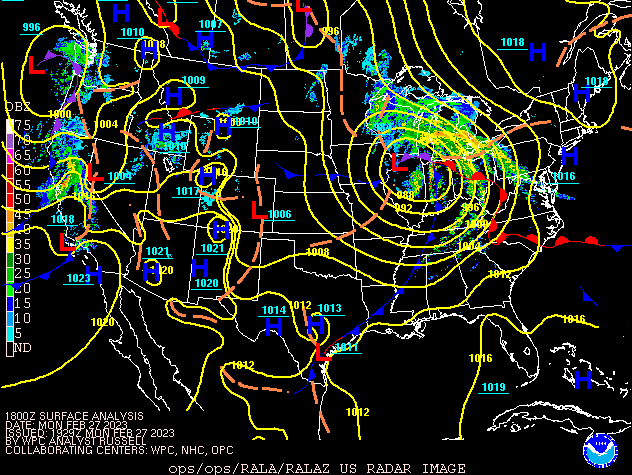
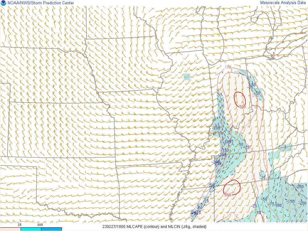
A strong low pressure system brought instability and shear to the area, allowing the severe storms and tornadoes to form.
 |
 |
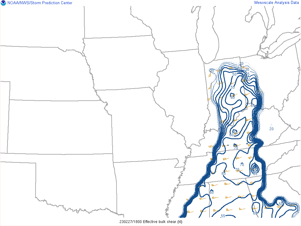 |
| Figure 1: Surface Map at 1 PM EST | Figure 2: Mixed Layer CAPE at 1 PM EST | Figure 3: Effective Shear at 1 PM EST |
 |
Media use of NWS Web News Stories is encouraged! Please acknowledge the NWS as the source of any news information accessed from this site. |
|