Overview
|
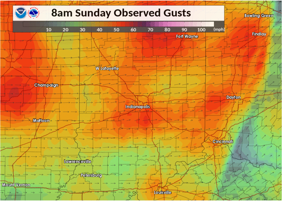
An intense area of low pressure brought damaging non-thunderstorm winds to central Indiana on February 24. Wind gusts over 60 mph were observed, with 66 mph at the Indianapolis International Airport. This was the highest non-thunderstorm wind gust reported there since April 6, 1988.
The winds caused damage to houses and other structures and brought down trees and power lines. Tens of thousands of people were without power. |
 Loop of Wind Gusts |
Winds
Public Information Statement
National Weather Service Indianapolis IN
638 PM EST Sun Feb 24 2019

...PEAK WIND REPORTS...

Location                     Speed     Time/Date       Provider

...Indiana...

...Bartholomew County...
Columbus Municipal Airport   51 MPH    0929 AM 02/24   AWOS

...Boone County...
5 NNE Zionsville             56 MPH    0559 AM 02/24   NONFEDAWOS
Indianapolis Terry Airport   56 MPH    0555 AM 02/24   AWOS

...Clinton County...
Frankfort                    52 MPH    0315 PM 02/24   AWOS

...Daviess County...
Daviess County Airport       48 MPH    0515 AM 02/24   AWOS

...Delaware County...
Delaware County-johnson Fiel 64 MPH    0611 AM 02/24   ASOS
Ball State University        51 MPH    0112 PM 02/24   CWOP
3 SSW Eaton                  40 MPH    0645 AM 02/24   CWOP

...Hamilton County...
3 SSE Noblesville            46 MPH    0630 AM 02/24   CWOP
3 SW Westfield               44 MPH    0542 AM 02/24   CWOP
2 WSW Cicero                 44 MPH    0545 AM 02/24   CWOP

...Hancock County...
4 SSE Mccordsville           55 MPH    0236 PM 02/24   NONFEDAWOS
Mt Comfort Airport           55 MPH    0236 PM 02/24   AWOS
2 WNW Spring Lake            46 MPH    0500 PM 02/24   CWOP
2 ENE Spring Lake            45 MPH    0645 AM 02/24   CWOP
2 SSE Fortville              45 MPH    1232 PM 02/24   CWOP

...Hendricks County...
2 NE Plainfield              48 MPH    0601 PM 02/24   CWOP
1 S Brownsburg               43 MPH    0341 PM 02/24   CWOP

...Howard County...
Kokomo Municipal Airport     58 MPH    0202 PM 02/24   AWOS
3 W Point Isabel             42 MPH    0315 PM 02/24   CWOP

...Johnson County...
1 ENE Greenwood              55 MPH    0235 PM 02/24   MESOWEST

...Lawrence County...
3 NNW Mitchell               43 MPH    0601 AM 02/24   CWOP
2 WSW Oolitic                42 MPH    0656 AM 02/24   CWOP

...Madison County...
Country Club Heights         50 MPH    0825 AM 02/24   CWOP
1 WNW Pendleton              50 MPH    0300 PM 02/24   CWOP
2 NNW River Forest           48 MPH    0438 PM 02/24   CWOP
Anderson Municipal Apt       47 MPH    0615 AM 02/24   AWOS
2 NW Chesterfield            41 MPH    0315 PM 02/24   CWOP
4 N Chesterfield             41 MPH    0910 AM 02/24   CWOP
1 SSE Pendleton              41 MPH    0600 PM 02/24   CWOP

...Marion County...
Indianapolis, In             66 MPH    0704 AM 02/24   ASOS
Eagle Creek Airpark Airport  60 MPH    0523 AM 02/24   ASOS
2 NW Crows Nest              47 MPH    0535 AM 02/24   CWOP
2 S Monument Circle          45 MPH    0230 PM 02/24   CWOP
3 ESE Beech Grove            43 MPH    0831 AM 02/24   CWOP

...Monroe County...
1 ENE Bloomington            52 MPH    0520 AM 02/24   CWOP
Monroe County Airport        49 MPH    0853 AM 02/24   ASOS
1 NW Ellettsville            46 MPH    0514 AM 02/24   CWOP

...Montgomery County...
1 N New Market               48 MPH    0255 PM 02/24   MESOWEST

...Morgan County...
2 NNW Lake Hart              44 MPH    0448 PM 02/24   CWOP

...Putnam County...
1 ESE Greencastle            45 MPH    0415 PM 02/24   MESOWEST

...Rush County...
Rushville                    43 MPH    0815 AM 02/24   CWOP

...Shelby County...
Shelbyville Municipal Airpor 56 MPH    0835 AM 02/24   ASOS
1 SSE New Palestine          51 MPH    0246 PM 02/24   CWOP

...Sullivan County...
3 ESE Sullivan               41 MPH    0510 AM 02/24   RAWS

...Tippecanoe County...
W. Lafayette - Purdue Univ.  59 MPH    0513 AM 02/24   ASOS
3 NE Lafayette               47 MPH    0211 PM 02/24   CWOP

...Tipton County...
2 E Sharpsville              50 MPH    0611 AM 02/24   CWOP

...Vermillion County...
Fairview Park                53 MPH    0416 AM 02/24   CWOP

...Vigo County...
2 NNW Terre Haute            63 MPH    0614 AM 02/24   CWOP
Hulman Regional Airport      61 MPH    0425 AM 02/24   ASOS
2 E Shepardsville            40 MPH    0420 AM 02/24   CWOP

Observations are collected from a variety of sources with varying
equipment and exposures. We thank all volunteer weather observers
for their dedication. Not all data listed are considered official.
Storm Reports
PRELIMINARY LOCAL STORM REPORT...SUMMARY
NATIONAL WEATHER SERVICE INDIANAPOLIS IN
635 PM EST SUN FEB 24 2019

..TIME...   ...EVENT...      ...CITY LOCATION...     ...LAT.LON...
..DATE...   ....MAG....      ..COUNTY LOCATION..ST.. ...SOURCE....
            ..REMARKS..

0416 AM     NON-TSTM WND GST FAIRVIEW PARK           39.69N 87.41W
02/24/2019  M53 MPH          VERMILLION         IN   MESONET


0420 AM     NON-TSTM WND GST 1 ENE BLOOMINGTON       39.17N 86.50W
02/24/2019  M48 MPH          MONROE             IN   MESONET


0425 AM     NON-TSTM WND GST 4 SW SEELYVILLE         39.45N 87.31W
02/24/2019  M61 MPH          VIGO               IN   ASOS

            ASOS STATION HUF, HULMAN REGIONAL AIRPORT.

0444 AM     NON-TSTM WND GST 2 SW PURDUE UNIVERSITY  40.41N 86.94W
02/24/2019  M58 MPH          TIPPECANOE         IN   ASOS

            ASOS STATION LAF, W. LAFAYETTE - PURDUE
            UNIVERSITY AIRPORT.

0450 AM     NON-TSTM WND GST GREENCASTLE             39.64N 86.84W
02/24/2019  M54 MPH          PUTNAM             IN   TRAINED SPOTTER


0452 AM     NON-TSTM WND GST INDIANAPOLIS INT`L AIRP 39.72N 86.29W
02/24/2019  M47 MPH          MARION             IN   ASOS

            ASOS STATION IND, INDIANAPOLIS INTERNATIONAL
            AIRPORT.

0513 AM     NON-TSTM WND GST 2 SW PURDUE UNIVERSITY  40.41N 86.94W
02/24/2019  M58 MPH          TIPPECANOE         IN   ASOS

            CORRECTS PREVIOUS NON-TSTM WND GST REPORT
            FROM 2 SW PURDUE UNIVERSITY. ASOS STATION
            LAF, W. LAFAYETTE - PURDUE UNIV. ARPT.

0514 AM     NON-TSTM WND GST 1 NW ELLETTSVILLE       39.24N 86.63W
02/24/2019  M46 MPH          MONROE             IN   MESONET

            MESONET STATION AR596, 1 NW ELLETTSVILLE.

0514 AM     NON-TSTM WND GST 2 N INDIANA STATE UNIVE 39.50N 87.40W
02/24/2019  M63 MPH          VIGO               IN   MESONET


0515 AM     NON-TSTM WND GST 4 NE WASHINGTON         38.70N 87.13W
02/24/2019  M48 MPH          DAVIESS            IN   AWOS

            AWOS STATION DCY, DAVIESS COUNTY AIRPORT.

0515 AM     NON-TSTM WND GST 3 W FRANKFORT           40.27N 86.56W
02/24/2019  M49 MPH          CLINTON            IN   AWOS

            AWOS STATION FKR, FRANKFORT.

0523 AM     NON-TSTM WND GST 1 SSE EAGLE CREEK RESER 39.83N 86.29W
02/24/2019  M59 MPH          MARION             IN   ASOS

            CORRECTS PREVIOUS NON-TSTM WND GST REPORT
            FROM 1 SSE EAGLE CREEK RESERVOIR. ASOS
            STATION EYE, EAGLE CREEK AIRPARK.

0533 AM     NON-TSTM WND GST INDIANAPOLIS INT`L AIRP 39.72N 86.29W
02/24/2019  M54 MPH          MARION             IN   ASOS

            ASOS STATION IND, INDIANAPOLIS, IN.

0535 AM     NON-TSTM WND GST 6 NNE ZIONSVILLE        40.03N 86.25W
02/24/2019  M49 MPH          BOONE              IN   AWOS

            AWOS STATION TYQ, INDIANAPOLIS TERRY
            AIRPORT.

0537 AM     NON-TSTM WND GST 5 NE KOKOMO             40.53N 86.06W
02/24/2019  M58 MPH          HOWARD             IN   AWOS

            AWOS STATION OKK, KOKOMO MUNICIPAL AIRPORT.

0552 AM     NON-TSTM WND GST 3 ESE FAIRLAND          39.58N 85.80W
02/24/2019  M49 MPH          SHELBY             IN   ASOS

            ASOS STATION GEZ, SHELBYVILLE MUNICIPAL
            AIRPORT.

0555 AM     NON-TSTM WND GST 6 NNE ZIONSVILLE        40.03N 86.25W
02/24/2019  M56 MPH          BOONE              IN   AWOS

            AWOS STATION TYQ, INDIANAPOLIS TERRY
            AIRPORT.

0556 AM     NON-TSTM WND GST 5 SSE MCCORDSVILLE      39.84N 85.90W
02/24/2019  M49 MPH          HANCOCK            IN   AWOS

            AWOS STATION MQJ, MT COMFORT AIRPORT.

0601 AM     NON-TSTM WND GST DANVILLE                39.76N 86.52W
02/24/2019  M46 MPH          HENDRICKS          IN   TRAINED SPOTTER

            MEASURED WITH HANDHELD ANEMOMETER.

0603 AM     NON-TSTM WND GST 3 NNW RIVER FOREST      40.15N 85.75W
02/24/2019  M47 MPH          MADISON            IN   MESONET


0610 AM     NON-TSTM WND DMG NOBLESVILLE             40.06N 86.03W
02/24/2019                   HAMILTON           IN   PUBLIC

            CHIMNEY PULLED AWAY FROM HOME NEAR
            NOBLESVILLE.

0610 AM     NON-TSTM WND GST 2 NW CROWS NEST         39.87N 86.20W
02/24/2019  M46 MPH          MARION             IN   MESONET


0611 AM     NON-TSTM WND GST 2 E SHARPSVILLE         40.38N 86.05W
02/24/2019  M50 MPH          TIPTON             IN   MESONET


0611 AM     NON-TSTM WND GST DELAWARE COUNTY AIRPORT 40.24N 85.39W
02/24/2019  M64 MPH          DELAWARE           IN   ASOS


0611 AM     NON-TSTM WND GST 2 SW ROYERTON           40.24N 85.39W
02/24/2019  M65 MPH          DELAWARE           IN   ASOS

            DELAWARE COUNTY AIRPORT.

0612 AM     NON-TSTM WND GST BALL STATE UNIVERSITY   40.20N 85.41W
02/24/2019  M51 MPH          DELAWARE           IN   MESONET


0615 AM     NON-TSTM WND GST 2 WSW CHESTERFIELD      40.10N 85.62W
02/24/2019  M47 MPH          MADISON            IN   AWOS

            AWOS STATION AID, ANDERSON MUNICIPAL APT.

0626 AM     NON-TSTM WND DMG MERIDIAN HILLS          39.88N 86.16W
02/24/2019                   MARION             IN   AMATEUR RADIO

            TWO HEALTHY TREES DOWNED BLOCKING THE
            SOUTHBOUND LANES OF MERIDIAN STREET.

0628 AM     NON-TSTM WND GST NEW WHITELAND           39.56N 86.10W
02/24/2019  M40 MPH          JOHNSON            IN   PUBLIC


0630 AM     NON-TSTM WND DMG ZIONSVILLE              39.95N 86.27W
02/24/2019                   BOONE              IN   LAW ENFORCEMENT

            POWER LINES DOWNED. REPORTED BY BOONE COUNTY
            SHERIFF.

0630 AM     NON-TSTM WND DMG 3 NW ELWOOD             40.31N 85.88W
02/24/2019                   TIPTON             IN   LAW ENFORCEMENT

            TRANSFORMER FIRE REPORTED BY TIPTON COUNTY
            SHERIFF.

0630 AM     NON-TSTM WND GST 3 SSE NOBLESVILLE       40.02N 86.01W
02/24/2019  M46 MPH          HAMILTON           IN   MESONET


0632 AM     NON-TSTM WND GST 3 SSW VINCENNES         38.64N 87.53W
02/24/2019  M46 MPH          KNOX               IN   EMERGENCY MNGR

            MEASURED GUST AT KNOX COUNTY EOC.

0645 AM     NON-TSTM WND GST 2 ENE SPRING LAKE       39.79N 85.82W
02/24/2019  M45 MPH          HANCOCK            IN   MESONET

            MESONET STATION AU689, 2 ENE SPRING LAKE.

0650 AM     NON-TSTM WND GST LAFAYETTE               40.42N 86.87W
02/24/2019  E60 MPH          TIPPECANOE         IN   PUBLIC


0651 AM     NON-TSTM WND GST 3 E BLANFORD            39.66N 87.47W
02/24/2019  M52 MPH          VERMILLION         IN   PUBLIC


0655 AM     NON-TSTM WND DMG 3 E BLANFORD            39.67N 87.46W
02/24/2019                   VERMILLION         IN   PUBLIC

            ROOFING MATERIAL BLOWN OFF FIRE STATION.

0703 AM     NON-TSTM WND DMG 3 WNW MERIDIAN HILLS    39.90N 86.20W
02/24/2019                   MARION             IN   AMATEUR RADIO

            TREE DOWNED INTO POWER LINES. ROAD BLOCKED.

0704 AM     NON-TSTM WND GST INDIANAPOLIS INT`L AIRP 39.72N 86.29W
02/24/2019  M65 MPH          MARION             IN   ASOS


0730 AM     NON-TSTM WND DMG 2 ENE MARTINSVILLE      39.43N 86.40W
02/24/2019                   MORGAN             IN   PUBLIC

            POWER LINE DOWN AND TRAFFIC LIGHTS OUT AT
            STATE ROAD 37 AND STATE ROAD 44.

0752 AM     NON-TSTM WND DMG CAMBY                   39.65N 86.31W
02/24/2019                   MARION             IN   PUBLIC

            GENERAL LOCATION OF REPORT. LARGE TREE LIMBS
            DOWN.

0825 AM     NON-TSTM WND GST 1 SSE COUNTRY CLUB HEIG 40.12N 85.68W
02/24/2019  M50 MPH          MADISON            IN   MESONET

            MESONET STATION AR814, COUNTRY CLUB HEIGHTS.

0831 AM     NON-TSTM WND DMG 3 WSW HELMSBURG         39.25N 86.34W
02/24/2019                   BROWN              IN   PUBLIC

            REPORT VIA SOCIAL MEDIA. SR 45 WAS CLOSED
            DUE TO LARGE TREE DOWN. AS OF 930AM, ROAD IS
            REPORTED OPEN.

0835 AM     NON-TSTM WND GST 3 ESE FAIRLAND          39.58N 85.80W
02/24/2019  M56 MPH          SHELBY             IN   ASOS


0845 AM     NON-TSTM WND DMG INDIANAPOLIS            39.78N 86.15W
02/24/2019                   MARION             IN   EMERGENCY MNGR

            OVER 11,000 PEOPLE WITHOUT POWER, ALL
            APPARENTLY DUE TO DOWNED POWER LINES FROM
            HIGH WINDS.

0853 AM     NON-TSTM WND GST 3 SW WHITEHALL          39.14N 86.62W
02/24/2019  M49 MPH          MONROE             IN   ASOS

            ASOS STATION BMG, MONROE COUNTY AIRPORT.

0929 AM     NON-TSTM WND GST 2 SW CLIFFORD           39.26N 85.90W
02/24/2019  M51 MPH          BARTHOLOMEW        IN   AWOS

            AWOS STATION BAK, COLUMBUS MUNICIPAL
            AIRPORT.

1024 AM     NON-TSTM WND DMG 3 ESE BROAD RIPPLE      39.85N 86.09W
02/24/2019                   MARION             IN   PUBLIC

            TWO HEALTHY 10 TO 12-INCH TREES DOWN,
            PARTIALLY IN ROADWAY SB EMERSON AT
            MILLERSVILLE ROAD.

1029 AM     NON-TSTM WND DMG 4 SW GASTON             40.28N 85.56W
02/24/2019                   DELAWARE           IN   NWS EMPLOYEE

            REPORT OF SEMI-BLOWN OVER ON I-69, NEAR MILE
            MARKER 245. EVENT OCCURRED NEAR 1000AM.

1034 AM     NON-TSTM WND DMG 2 N COUNTRY CLUB HEIGHT 40.15N 85.69W
02/24/2019                   MADISON            IN   PUBLIC

            WIND IS PEELING FASCIA FROM ROOF LINES, AND
            SOME SHINGLES.

1113 AM     NON-TSTM WND DMG 2 SSE FISHERS           39.93N 86.01W
02/24/2019                   HAMILTON           IN   PUBLIC

            MODERATE SIZE TREE WAS BLOWN DOWN NEAR 96TH
            STREET AND LANTERN ROAD...STRIKING DECK
            RAILING AND HOT TUB.

1200 PM     NON-TSTM WND DMG 1 NE CARMEL             39.99N 86.10W
02/24/2019                   HAMILTON           IN   PUBLIC

            TWELVE-INCH DIAMETER 56-FOOT TALL EVERGREEN
            TREE WAS UPROOTED BY HIGH WINDS...CAUSING
            HOUSE GUTTER AND MINOR SIDING DAMAGE.
            REPORTED BY RETIRED NWS EMPLOYEE. TIME
            INDICATED IS THE APPROXIMATE TIME RECEIVED.

1232 PM     NON-TSTM WND GST 2 SSE FORTVILLE         39.90N 85.83W
02/24/2019  M45 MPH          HANCOCK            IN   MESONET

            MESONET STATION D7754, 2 SSE FORTVILLE.

0117 PM     NON-TSTM WND DMG 3 NW INGALLS            39.99N 85.83W
02/24/2019                   MADISON            IN   EMERGENCY MNGR

            SEMI TRUCK WAS BLOWN OFF INTERSTATE 69 AT
            MILE MARKER 215, JUST EAST OF THE STATE ROAD
            13 EXIT. TIME IS THE TIME OF REPORT. TIME OF
            OCCURRENCE IS UNKNOWN.

0153 PM     NON-TSTM WND DMG 1 SSE CLOVERDALE        39.51N 86.79W
02/24/2019                   PUTNAM             IN   EMERGENCY MNGR

            HIGH WIND HAS CAUSED A PARTIAL COLLAPSE OF A
            BUILDING AT 5 NORTH MAIN STREET IN DOWNTOWN
            CLOVERDALE ON US 231...PROMPTING CLOSURE OF
            THE NORTHBOUND LANE.

0211 PM     NON-TSTM WND GST 4 NNE LAFAYETTE         40.45N 86.83W
02/24/2019  M47 MPH          TIPPECANOE         IN   MESONET

            MESONET STATION AT573, 3 NE LAFAYETTE.

0215 PM     NON-TSTM WND GST 2 N NEW MARKET          39.98N 86.92W
02/24/2019  M45 MPH          MONTGOMERY         IN   MESONET

            MESONET STATION KCFJ, 1 N NEW MARKET.

0230 PM     NON-TSTM WND GST 3 S MONUMENT CIRCLE     39.73N 86.16W
02/24/2019  M45 MPH          MARION             IN   MESONET

            MESONET STATION E0483, 2 S MONUMENT CIRCLE.

0235 PM     NON-TSTM WND GST 2 ENE GREENWOOD         39.63N 86.09W
02/24/2019  M55 MPH          JOHNSON            IN   MESONET

            MESONET STATION KHFY, 1 ENE GREENWOOD.

0246 PM     NON-TSTM WND GST 2 SSE NEW PALESTINE     39.70N 85.88W
02/24/2019  M51 MPH          SHELBY             IN   MESONET

            MESONET STATION AV182, 1 SSE NEW PALESTINE.

0300 PM     NON-TSTM WND GST 2 WNW PENDLETON         40.01N 85.77W
02/24/2019  M50 MPH          MADISON            IN   MESONET

            MESONET STATION AU584, 1 WNW PENDLETON.

0358 PM     NON-TSTM WND DMG 1 NNE ANDERSON          40.11N 85.68W
02/24/2019                   MADISON            IN   EMERGENCY MNGR

            EMERGENCY MANAGER REPORTS THAT THE PART OF
            THE ROOF OF THE COURTHOUSE WAS DAMAGED BY
            THE WIND. ACROSS THE COUNTY MANY HOMES
            EXPERIENCED ROOF DAMAGE. EMERGENCY PERSONNEL
            HAVE RESPONDED TO NUMEROUS REQUESTS OF TREES
            AND POWER LINES ACROSS ROAD THROUGH THE DAY.

0400 PM     NON-TSTM WND DMG 4 NNW DALEVILLE         40.18N 85.58W
02/24/2019                   MADISON            IN   EMERGENCY MNGR

            40X80 FOOT POLE BARN ROOF COMPLETELY BLOWN
            OFF WITH DAMAGE TO ONE VEHICLE.

0415 PM     NON-TSTM WND GST 1 ESE GREENCASTLE       39.64N 86.82W
02/24/2019  M45 MPH          PUTNAM             IN   MESONET

            MESONET STATION KGPC, 1 ESE GREENCASTLE.

0446 PM     NON-TSTM WND GST 3 SSE AVON              39.73N 86.36W
02/24/2019  M46 MPH          HENDRICKS          IN   MESONET

            MESONET STATION E8045, 2 NE PLAINFIELD.

0451 PM     NON-TSTM WND DMG 4 SSW ELWOOD            40.22N 85.86W
02/24/2019                   MADISON            IN   EMERGENCY MNGR

            SR 37 BETWEEN SR 128 AND SR 13 CLOSED DUE TO
            TREES DOWN. ONE TREE DOWN WAS OVER 3 FEET IN
            DIAMETER.

0500 PM     NON-TSTM WND GST 3 WNW SPRING LAKE       39.80N 85.90W
02/24/2019  M46 MPH          HANCOCK            IN   MESONET

            MESONET STATION AU410, 2 WNW SPRING LAKE.
Environment
Video Loops: Below are loops of data from this event. All loops are from NWS Quad Cities
| Figure 1: GOES 16 Water Vapor | Figure 2: MSAS Mean Sea Level Pressure | Figure 3: MSAS 3-hr Pressure Change |
Additional Information
Summaries from other NWS Offices
 |
Media use of NWS Web News Stories is encouraged! Please acknowledge the NWS as the source of any news information accessed from this site. |
|

