Overview
|
A strong area of low pressure brought some severe thunderstorms to central Indiana late on December 10 into the early morning hours of December 11. Damage was mainly confined to trees and power lines down, but some structures had damage as well. More significant severe weather took place across areas to the south and west of Indiana. During the daylight hours of December 11, strong non-thunderstorm winds were observed across central Indiana. Winds gusted to over 50 mph at many locations during the day. A summary of winds is available. |
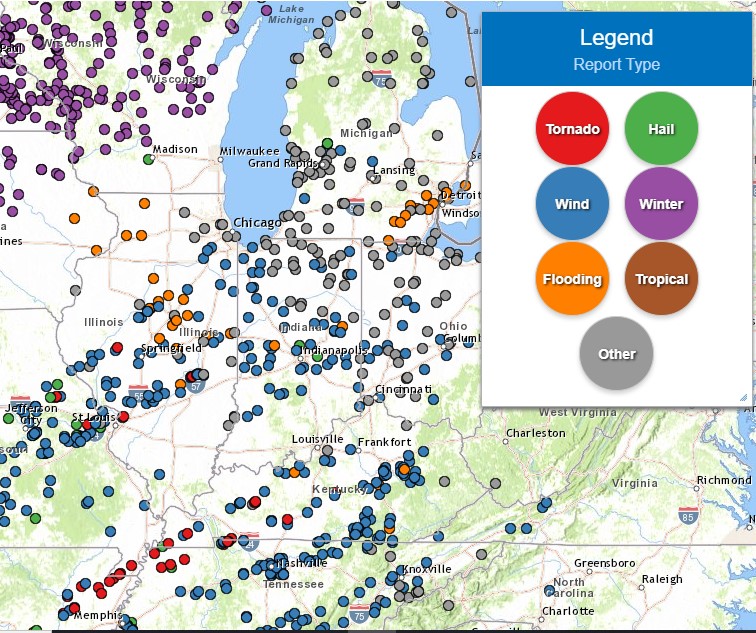 Map of Preliminary Storm Reports |
Radar
NWS Indianapolis Radar Loop from 10 PM EST December 10 to 4 AM EST December 11
Storm Reports
Map of Preliminary Storm Reports as of 5 PM EST December 11
Below are a list of storm reports received by NWS Indianapolis
PRELIMINARY LOCAL STORM REPORT...SUMMARY
NATIONAL WEATHER SERVICE INDIANAPOLIS IN
522 PM EST SAT DEC 11 2021

..TIME...   ...EVENT...      ...CITY LOCATION...     ...LAT.LON...
..DATE...   ....MAG....      ..COUNTY LOCATION..ST.. ...SOURCE....
            ..REMARKS..

0938 PM     TSTM WND DMG     2 E GREENWOOD           39.61N 86.08W
12/10/2021                   JOHNSON            IN   BROADCAST MEDIA

            LARGE RED ROOF INN SIGN BLEW OVER ONTO CAR
            IN PARKING LOT. TIME ESTIMATED FROM RADAR.

0945 PM     TSTM WND DMG     3 NE GNAW BONE          39.21N 86.12W
12/10/2021                   BROWN              IN   911 CALL CENTER

            TREES AND POWER LINES DOWN ALL OVER BROWN
            COUNTY. TIME ESTIMATED FROM RADAR.

1155 PM     TSTM WND DMG     2 W PINE VILLAGE        40.45N 87.28W
12/10/2021                   WARREN             IN   911 CALL CENTER

            TREES DOWN ON INDIANA ROUTE 26 WEST OF PINE
            VILLAGE. TIME ESTIMATED FROM RADAR.

1155 PM     TSTM WND DMG     KINGMAN                 39.97N 87.28W
12/10/2021                   FOUNTAIN           IN   AMATEUR RADIO

            GRAIN BINS BLOW OVER TIME ESTIMATED FROM
            RADAR.

1155 PM     TSTM WND DMG     LODI                    39.95N 87.40W
12/10/2021                   FOUNTAIN           IN   911 CALL CENTER

            TREES DOWN IN WEST AND SOUTHWEST FOUNTAIN
            COUNTY. TIME ESTIMATED FROM RADAR.

1205 AM     TSTM WND DMG     1 ENE ARLINGTON         39.65N 85.56W
12/11/2021                   RUSH               IN   EMERGENCY MNGR

            REPORTS OF TREES DOWN AROUND THE COUNTY.
            REPORTS BEGAN TO COME IN TO DISPATCH AFTER
            MORRISTOWN LOST POWER AROUND MIDNIGHT.

1206 AM     TSTM WND DMG     4 SW SPENCER            39.25N 86.82W
12/11/2021                   OWEN               IN   AMATEUR RADIO

            AT LEAST 4 TREES DOWN PROMPTED IN67 CLOSED
            BETWEEN CARP AND FREEDOM. TIME ESTIMATED
            FROM RADAR.

1210 AM     TSTM WND DMG     1 SW ELNORA             38.87N 87.10W
12/11/2021                   DAVIESS            IN   911 CALL CENTER

            TREE DOWNED ONTO INDIANA ROUTE 57 AT EAST
            COUNTY ROAD 1450 NORTH. TIME ESTIMATED FROM
            RADAR.

1220 AM     TSTM WND DMG     BICKNELL                38.77N 87.31W
12/11/2021                   KNOX               IN   911 CALL CENTER

            TREE BLOWN ACROSS ROAD AND LIGHTNING STRUCK
            A POLE ON FIRE. TIME ESTIMATED FROM RADAR.

1225 AM     TSTM WND DMG     4 ENE NEW MARKET        39.97N 86.85W
12/11/2021                   MONTGOMERY         IN   PUBLIC

            POWER LINES DOWN. TIME ESTIMATED FROM RADAR.

1230 AM     HAIL             GREENFIELD              39.79N 85.77W
12/11/2021  E0.25 INCH       HANCOCK            IN   PUBLIC


1245 AM     TSTM WND DMG     FLORA                   40.55N 86.53W
12/11/2021                   CARROLL            IN   911 CALL CENTER

            NUMEROUS TREES AND POWER LINES DOWN IN THE
            CAMDEN AND FLORA AREAS. TIME ESTIMATED FROM
            RADAR.

0101 AM     TSTM WND DMG     1 E LADOGA              39.92N 86.78W
12/11/2021                   MONTGOMERY         IN   PUBLIC

            LARGE BRACHES AND TREES DOWN. TIME ESTIMATED
            FROM RADAR.

0115 AM     TSTM WND DMG     5 N ELWOOD              40.35N 85.84W
12/11/2021                   MADISON            IN   EMERGENCY MNGR

            SEVERAL TREES DOWN AROUND NORTHERN PARTS OF
            COUNTY, POWER POLES DOWN AS WELL. TIME
            ESTIMATED FROM RADAR.

0115 AM     TSTM WND DMG     1 E FRANKFORT           40.28N 86.50W
12/11/2021                   CLINTON            IN   PUBLIC

            REPORT FROM MPING: 3-INCH TREE LIMBS BROKEN;
            POWER POLES BROKEN.

0120 AM     TSTM WND DMG     ROCKVILLE               39.76N 87.23W
12/11/2021                   PARKE              IN   911 CALL CENTER

            NUMEROUS TREES DOWN ACROSS PARKE COUNTY.
            TIME ESTIMATED FROM RADAR.

0124 AM     TSTM WND GST     3 ENE SHEPARDSVILLE     39.61N 87.37W
12/11/2021  E50 MPH          PARKE              IN   AMATEUR RADIO

            VERY HEAVY RAIN.

0130 AM     TSTM WND DMG     1 SSE SUMMITVILLE       40.33N 85.64W
12/11/2021                   MADISON            IN   EMERGENCY MNGR

            SEVERAL TREES AND SOME POWER POLES DOWN
            ACROSS MAINLY NORTHERN MADISON COUNTY. TIME
            ESTIMATED FROM RADAR.

0150 AM     TSTM WND DMG     2 WNW NEW WHITELAND     39.57N 86.14W
12/11/2021                   JOHNSON            IN   EMERGENCY MNGR

            ELECTRIC POLES AND SOME TREES DOWN IN THE
            COUNTY. TRANSFORMER FIRE IN SOUTHERN PART OF
            THE COUNTY.

0150 AM     TSTM WND DMG     3 S CARBON              39.56N 87.11W
12/11/2021                   CLAY               IN   911 CALL CENTER

            NUMEROUS TREES AND POWER LINES DOWN ACROSS
            NORTHERN CLAY COUNTY. TIME ESTIMATED FROM
            RADAR.

0200 AM     TSTM WND DMG     BAINBRIDGE              39.76N 86.81W
12/11/2021                   PUTNAM             IN   911 CALL CENTER

            SEVERAL REPORTS OF TREES AND POWER LINES
            ACROSS NORTHEASTERN PUTNAM COUNTY. TIME
            ESTIMATED FROM RADAR.

0202 AM     FLOOD            NEW ROSS                39.97N 86.72W
12/11/2021                   MONTGOMERY         IN   PUBLIC

            FIELDS FLOODING OVER ON SOME ROADWAYS.

0205 AM     TSTM WND DMG     GREENCASTLE             39.64N 86.85W
12/11/2021                   PUTNAM             IN   911 CALL CENTER

            NUMEROUS REPORTS OF DOWNED TREES AND POWER
            LINES ACROSS CENTRAL PUTNAM COUNTY. TIME
            ESTIMATED FROM RADAR.

0222 AM     TSTM WND GST     4 SSE ZIONSVILLE        39.90N 86.24W
12/11/2021  M65 MPH          MARION             IN   AMATEUR RADIO

            AT 79TH AND GEORGETOWN.

0225 AM     HAIL             3 W CARMEL              39.98N 86.16W
12/11/2021  U0.75 INCH       HAMILTON           IN   PUBLIC

            REPORT FROM MPING: DIME (0.75 IN.).

0236 AM     TSTM WND GST     6 NW FORTVILLE          40.00N 85.92W
12/11/2021  M61 MPH          HAMILTON           IN   PUBLIC

            NOBLESVILLE NEAR THE MUSIC CENTER RELAYED
            VIA TWITTER.

0253 AM     TSTM WND GST     3 WSW WHITEHALL         39.15N 86.62W
12/11/2021  M59 MPH          MONROE             IN   ASOS

            ASOS STATION KBMG BLOOMINGTON.

0253 AM     TSTM WND GST     3 NNE BALL STATE UNIVER 40.23N 85.40W
12/11/2021  M59 MPH          DELAWARE           IN   ASOS

            ASOS STATION KMIE MUNCIE.

0254 AM     TSTM WND GST     1 NW INDIANA UNIVERSITY 39.17N 86.53W
12/11/2021  E50 MPH          MONROE             IN   PUBLIC

            PEA SIZE HAIL AS WELL.

0257 AM     TSTM WND DMG     1 N BALL STATE UNIVERSI 40.21N 85.41W
12/11/2021                   DELAWARE           IN   PUBLIC

            REPORT FROM MPING: 1-INCH TREE LIMBS BROKEN;
            SHINGLES BLOWN OFF.

0305 AM     TSTM WND DMG     SELMA                   40.19N 85.27W
12/11/2021                   DELAWARE           IN   911 CALL CENTER

            NUMEROUS REPORTS OF DOWNED TREES AND OR
            POWER LINES ACROSS SOUTHEAST DELAWARE
            COUNTY. TIME ESTIMATED FROM RADAR.

0307 AM     FLOOD            ALBANY                  40.30N 85.23W
12/11/2021                   DELAWARE           IN   AMATEUR RADIO

            MINOR FLOODING OF AROUND 1 FOOT DEPTH IN
            DOWNTOWN ALBANY NEAR FIRE STATION. RAIN
            OVERWHELMING STORM DRAINS.

0334 AM     TSTM WND GST     3 ESE FAIRLAND          39.58N 85.80W
12/11/2021  M59 MPH          SHELBY             IN   ASOS

            ASOS STATION KGEZ SHELBYVILLE.

0348 AM     TSTM WND DMG     1 W MAYS                39.74N 85.44W
12/11/2021                   RUSH               IN   911 CALL CENTER

            TREE BLOWN ONTO INDIANA ROUTE 9 NEAR EAST
            COUNTY ROAD 900 NORTH. TIME ESTIMATED FROM
            RADAR.
Environment
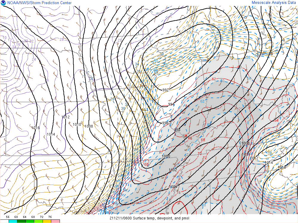
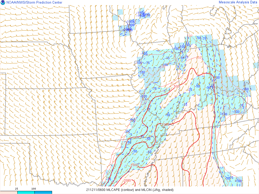
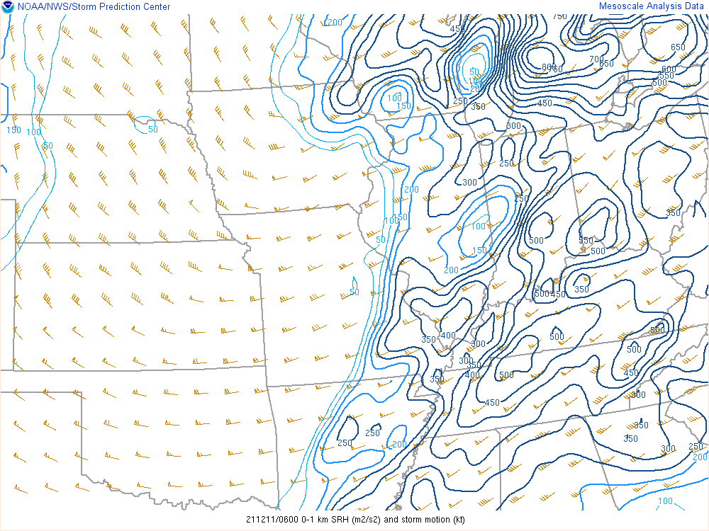
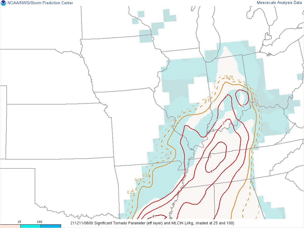
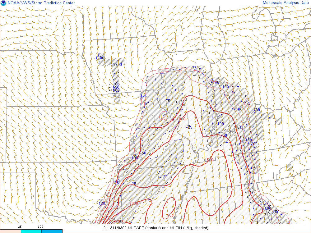
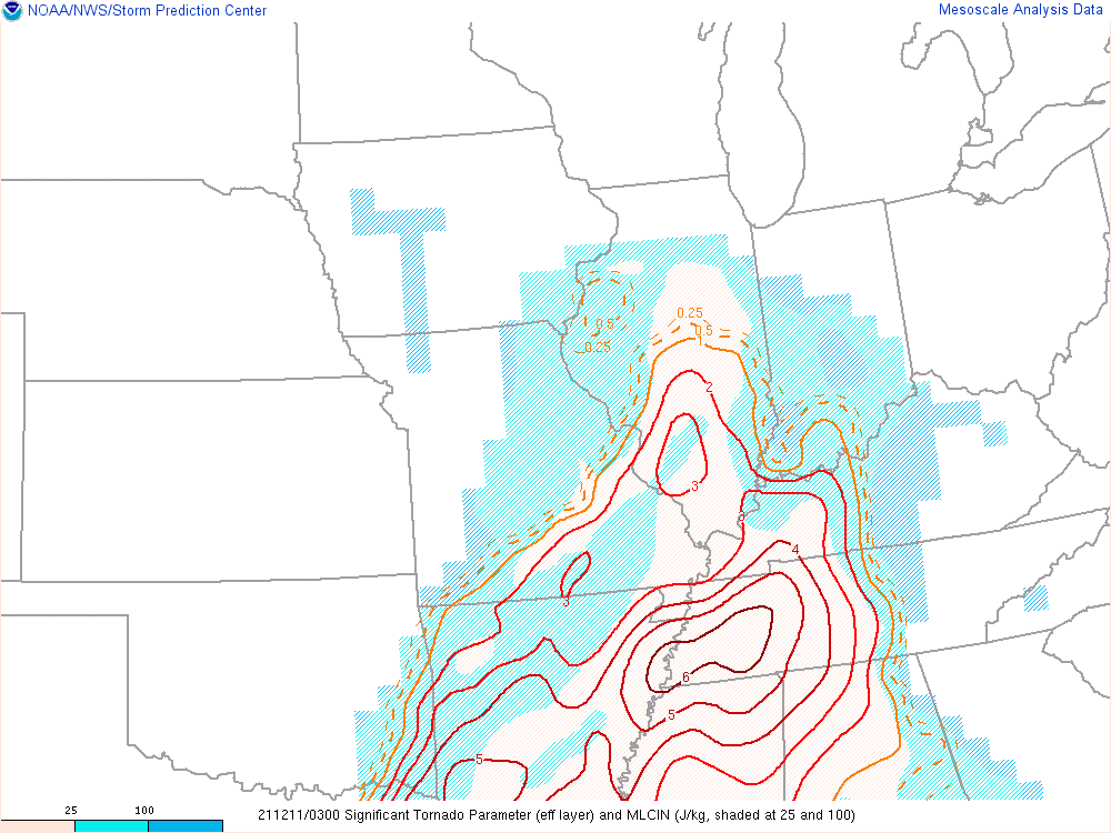
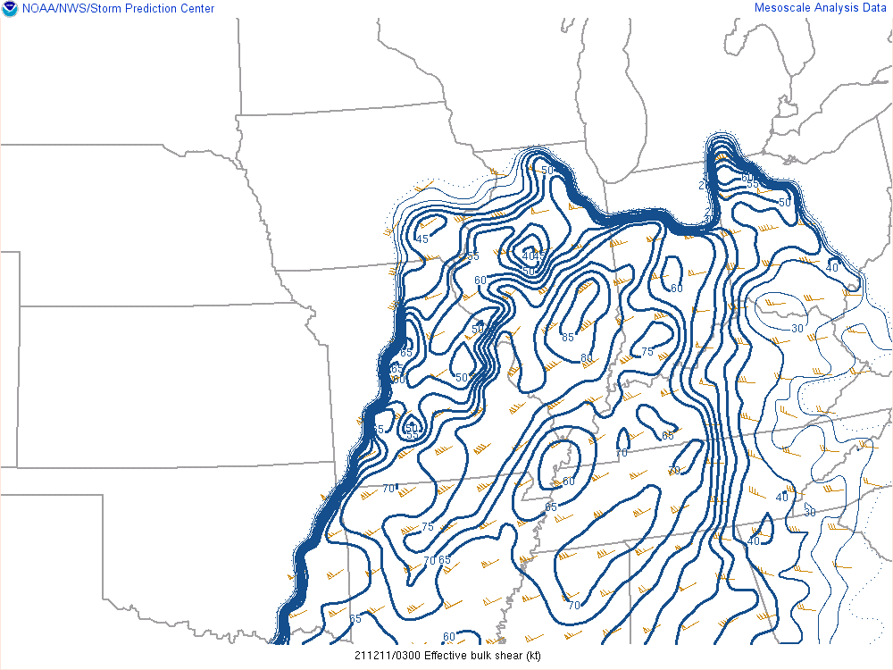
A strong area of surface low pressure along with strong winds aloft brought severe thunderstorms to parts of central Indiana, with widespread severe weather to the west and south of Indiana. The images below are a snapshot of some environmental parameters at 1:00 AM EST December 11.
 |
 |
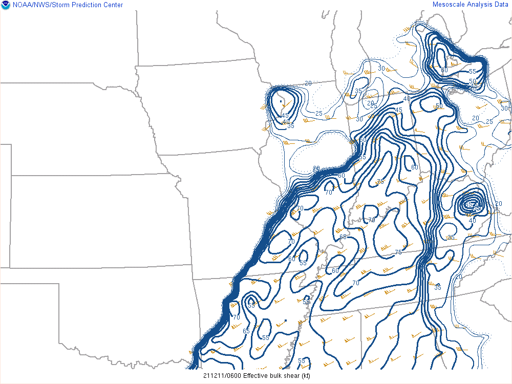 |
| Figure 1: Surface Pressure, Temp, Dewpoint | Figure 2: Mixed Layer CAPE | Figure 3: Effective Shear |
 |
 |
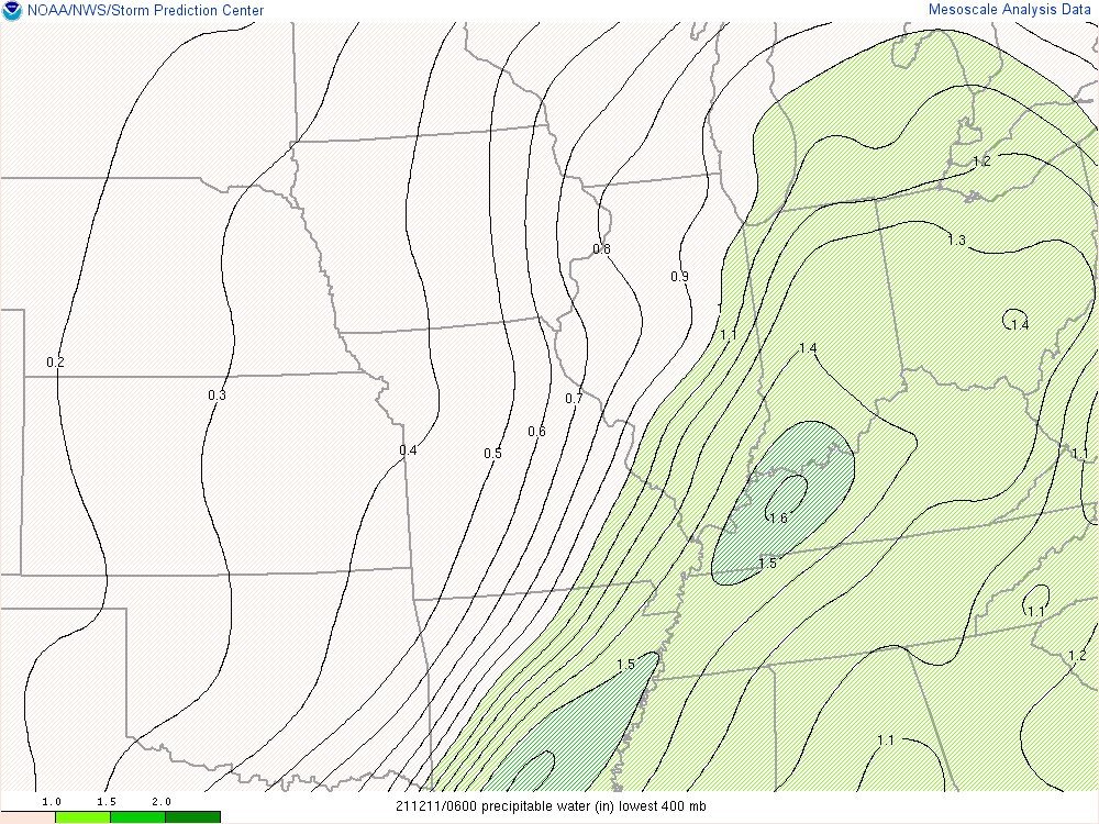 |
| Figure 4: Storm Relative Helicity | Figure 5: Significant Tornado Parameter (effective layer) | Figure 6: Precipitable Water |
 |
 |
 |
| Figure 7: Animated GIF of Mixed Layer CAPE from 10 PM to 4 AM Dec 10-11 | Figure 8:Animated GIF of Significant Tornado Parameter from 10 PM to 4 AM Dec 10-11 | Figure 9: Animated GIF of Effective Shear from 10 PM to 4 AM Dec 10-11 |
The low pressure area brought in extremely warm and moist air for December, and the warmest temperatures occurred early in the overnight. Indianapolis tied the record high for December 11 of 66 degrees. The high temperature was set at 2:40 AM EST.
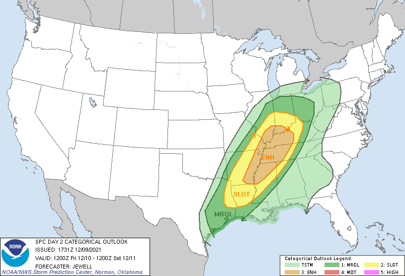
The Forecast
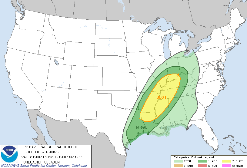 |
 |
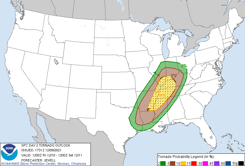 |
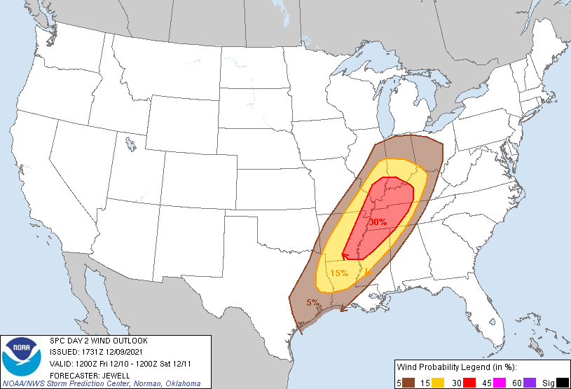 |
| SPC Day 3 Categorical Outlook | SPC Day 2 Categorical Outlook | SPC Day 2 Tornado Outlook | SPC Day 2 Wind Outlook |
 |
 |
 |
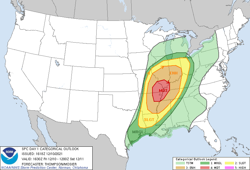
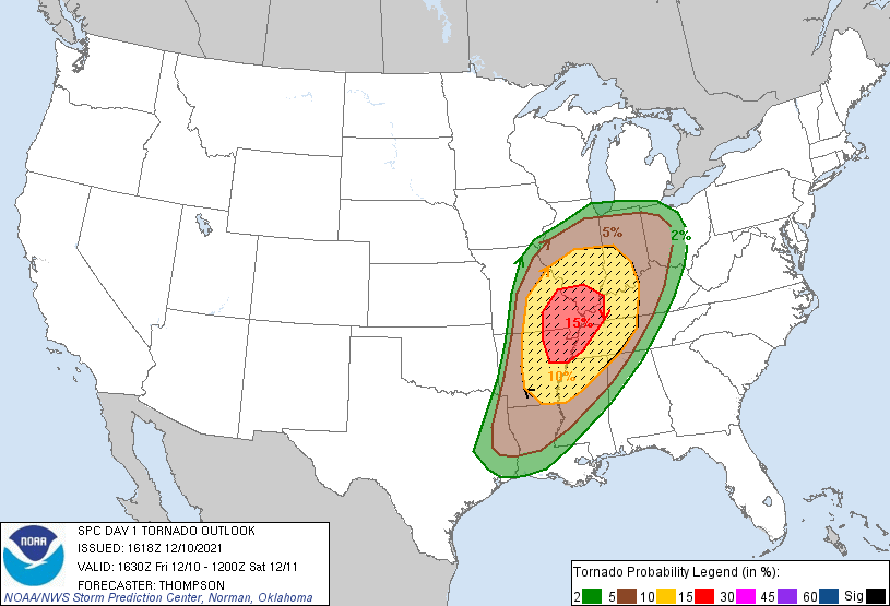
|
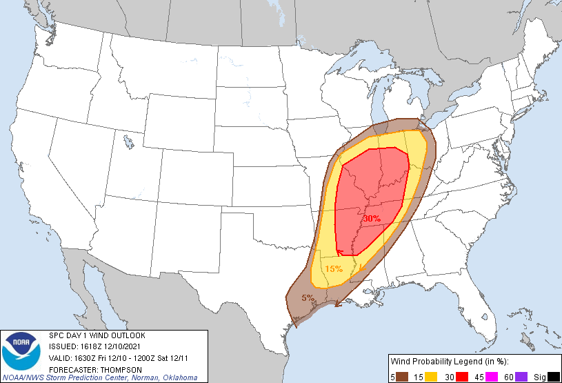
| SPC Day 1 Categorical Outlook | SPC Day 1 Tornado Outlook | SPC Day 1 Wind Outlook |
Watches
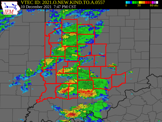 |
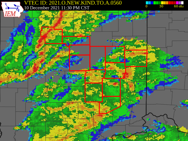 |
| Figure 1: Tornado Watch 557 | Figure 2: Tornado Watch 560 |
These were the first tornado watches of 2021 for most of central Indiana.
The Storm Prediction Center's archive of this event has more information.
Summaries from Nearby NWS Offices
Below are links to nearby office information on this event (where available). Links may change with time. Check out the offices' main pages if needed.
 |
Media use of NWS Web News Stories is encouraged! Please acknowledge the NWS as the source of any news information accessed from this site. |
|

