Overview
|
On April 29, a line of severe thunderstorms produced damaging winds that damaged buildings and knocked down power poles and power lines. Later that day, more storms developed and produced large hail and damaging winds. On April 30, scattered storms produced large hail. |
Storm Reports
Below are storm reports received by NWS Indianapolis for these 2 days.
April 29
Preliminary Local Storm Report
National Weather Service Indianapolis IN

..TIME...   ...EVENT...      ...CITY LOCATION...     ...LAT.LON...
..DATE...   ....MAG....      ..COUNTY LOCATION..ST.. ...SOURCE....
            ..REMARKS..

0845 AM     Lightning        4 N Daleville           40.17N 85.57W
04/29/2025                   Delaware           IN   Broadcast Media

            A car was struck by lightning on Interstate
            69 with significant damage to the vehicle.
            Location and time estimated.

1041 AM     Hail             Lyons                   38.99N 87.08W
04/29/2025  M1.00 Inch       Greene             IN   Trained Spotter

1041 AM     Tstm Wnd Dmg     2 S Linton              39.01N 87.16W
04/29/2025                   Greene             IN   Emergency Mngr

            Delayed report. A horse trailer was lifted
            and thrown with nearby power lines and tree
            damage. Several other structures had damage
            in the area.

1138 AM     Tstm Wnd Gst     Martinsville            39.43N 86.42W
04/29/2025  M65 MPH          Morgan             IN   Trained Spotter

1214 PM     Tstm Wnd Gst     3 ESE Fairland          39.59N 85.81W
04/29/2025  M64 MPH          Shelby             IN   ASOS

            56KT gust recorded at KGEZ.

1230 PM     Tstm Wnd Dmg     3 S New Salem           39.49N 85.36W
04/29/2025                   Rush               IN   Emergency Mngr

            4 structures damaged between 950 East and
            1000S to an area from 900N to 700 East.

1230 PM     Tstm Wnd Dmg     3 S New Salem           39.49N 85.36W
04/29/2025                   Rush               IN   Emergency Mngr

            5 power poles and a tree down on 450 E south
            of 244.

1240 PM     Tstm Wnd Dmg     2 ENE Sandusky          39.43N 85.44W
04/29/2025                   Decatur            IN   Emergency Mngr

            Tree down. Time approximated form radar.

1235 PM     Tstm Wnd Dmg     Greensburg              39.34N 85.48W
04/29/2025                   Decatur            IN   Public

            Tree snapped onto garage.

0455 PM     Hail             Fairland                39.60N 85.86W
04/29/2025  M0.75 Inch       Shelby             IN   Amateur Radio


0458 PM     Tstm Wnd Dmg     Wheatland               38.66N 87.31W
04/29/2025                   Knox               IN   Emergency Mngr

            Tree across Enley Road.

0458 PM     Tstm Wnd Dmg     3 WSW Monroe City       38.60N 87.42W
04/29/2025                   Knox               IN   Emergency Mngr

            Tree down on Hart Street Road.

0503 PM     Flash Flood      3 E Odon                38.85N 86.93W
04/29/2025                   Daviess            IN   Public

            Water across a road and flowing through
            fields.

0504 PM     Tstm Wnd Dmg     Decker                  38.52N 87.52W
04/29/2025                   Knox               IN   Emergency Mngr

            Reported structural collapse of the front
            side of the town hall.

0511 PM     Hail             2 W Hayden              38.97N 85.77W
04/29/2025  M0.75 Inch       Jennings           IN   Public

            Report from mPING: Dime (0.75 in.).
April 30
Preliminary Local Storm Report
National Weather Service Indianapolis IN
..TIME... ...EVENT... ...CITY LOCATION... ...LAT.LON...
..DATE... ....MAG.... ..COUNTY LOCATION..ST.. ...SOURCE....
..REMARKS..
0536 PM Hail 3 N Glendale 38.62N 87.07W
04/30/2025 E1.50 Inch Daviess IN Public
Public report received from X.
0539 PM Hail 5 NW Glendale Fishery 38.59N 87.11W
04/30/2025 M1.00 Inch Daviess IN Public
Report from mPING: Quarter (1.00 in.).
0540 PM Hail 5 SE Washington 38.61N 87.11W
04/30/2025 M1.00 Inch Daviess IN Public
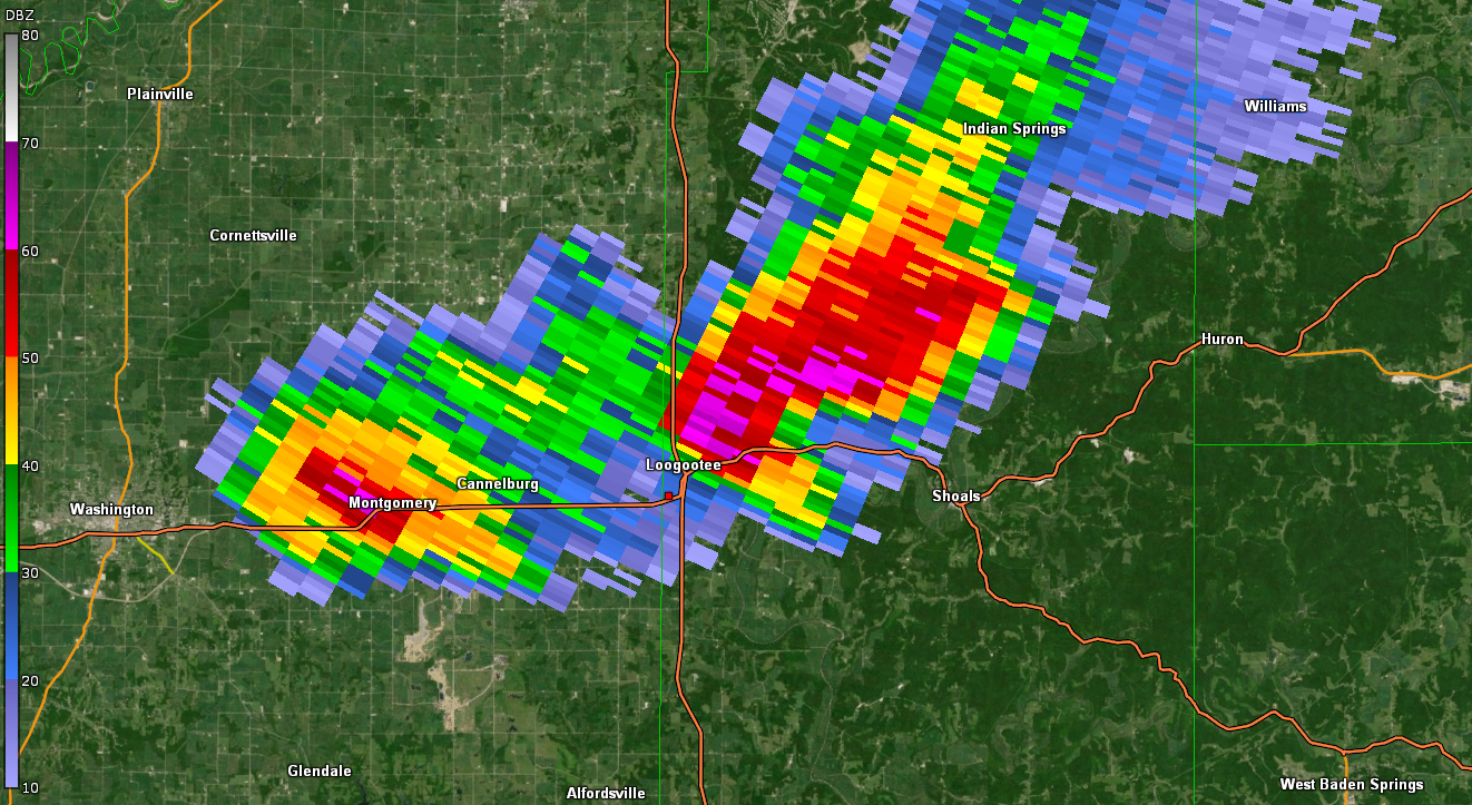
0622 PM Hail 1 NW Loogootee 38.68N 86.92W
04/30/2025 M1.25 Inch Martin IN Public
0628 PM Hail Shoals 38.67N 86.79W
04/30/2025 E1.75 Inch Martin IN Emergency Mngr
0632 PM Hail Loogootee 38.68N 86.92W
04/30/2025 E2.00 Inch Martin IN Emergency Mngr
Received pictures of report.
0712 PM Hail 1 ENE Williams 38.81N 86.63W
04/30/2025 E1.00 Inch Lawrence IN CO-OP Observer
Williams Dam CO-OP observer reports 1 inch
hail.
0753 PM Hail 3 W Pleasant View 38.88N 86.26W
04/30/2025 E0.50 Inch Jackson IN Public
Report from mPING: Half-inch (0.50 in.).
0830 PM Hail Burns City 38.82N 86.89W
04/30/2025 E1.00 Inch Martin IN Amateur Radio
0858 PM Hail 5 E Brownstown 38.87N 85.95W
04/30/2025 E0.75 Inch Jackson IN Public
Report from mPING: Dime (0.75 in.).
0903 PM Hail 4 S Seymour 38.90N 85.88W
04/30/2025 E1.25 Inch Jackson IN Broadcast Media
Report from Media. Time based upon radar.
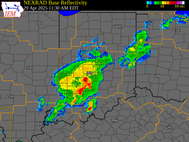
Radar
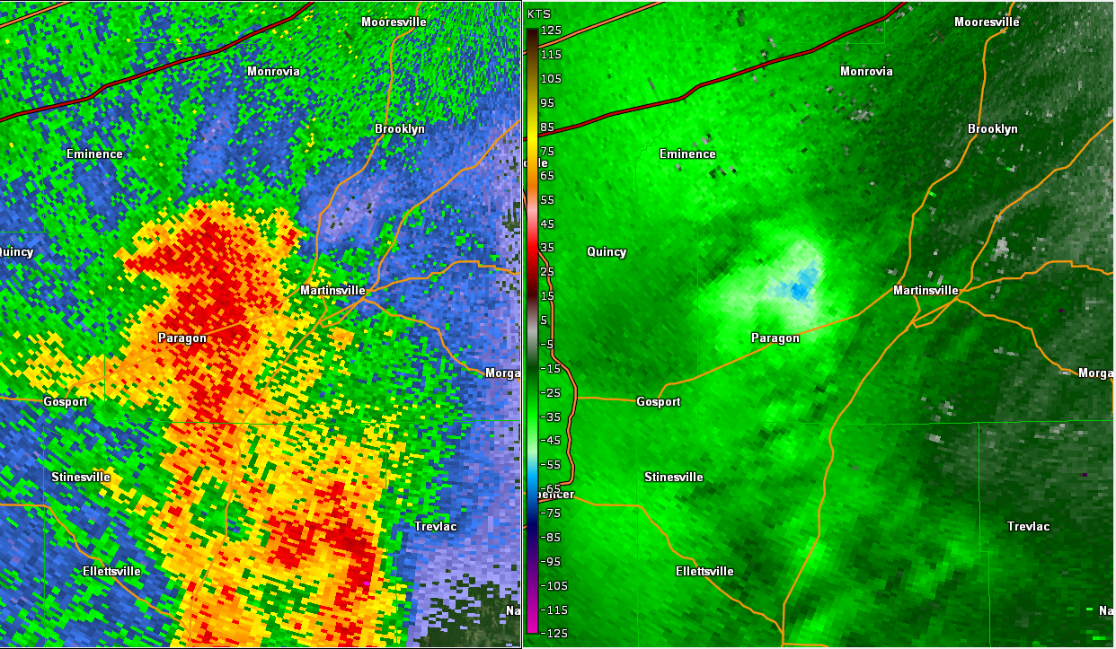
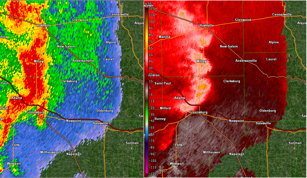
Selected images from April 29. A loop is available.
 |
 |
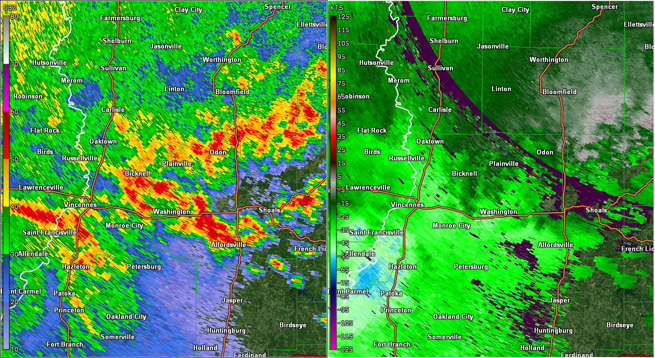 |
| Radar/Velocity at 11:29 AM EDT | Radar/Velocity at 12:29 PM EDT | Radar/Velocity at 5:03 PM EDT |
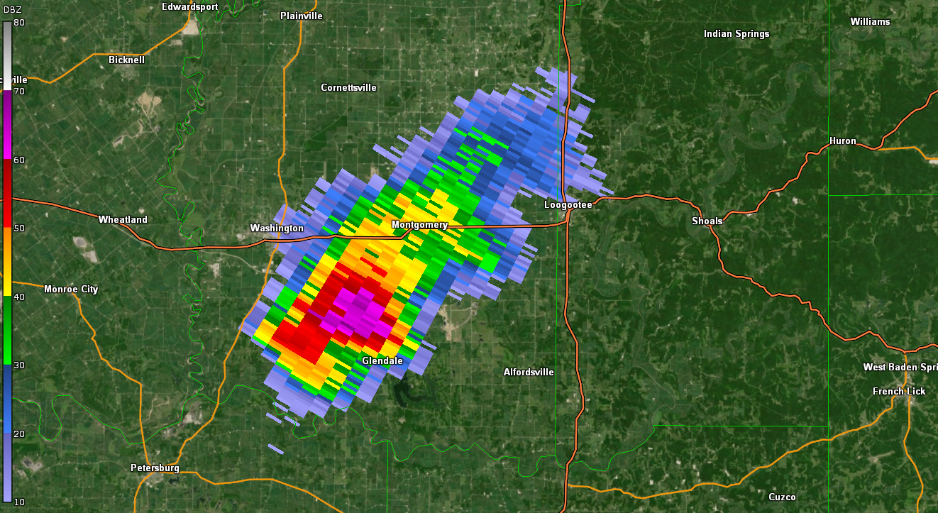
Selected images from April 30
 |
 |
| Radar at 5:36 PM EDT | Radar at 6:25 PM EDT |
 |
Media use of NWS Web News Stories is encouraged! Please acknowledge the NWS as the source of any news information accessed from this site. |
|

