Overview
A strong low pressure system tracked from the Southern Plains into the Ohio Valley going into the 25th with the surface low generally moving just north of the Ohio River during the late overnight hours and early daytime hours of January 25th. A surge of warm air pushed out ahead of the low leading to rain being the predominant precipitation type initially before a transition into a heavy wet snow. Snow to liquid ratios through the early portion of the event were around 3-5:1 but that was also due to the significant melting that occurred through the course of the entire event. A broad deformation band set up to the northwest of the surface low, but never quite tightened up to create the extreme snow rates that would have been needed to get the higher snow totals with the melting. Snow began to taper off after 11AM with little to no accumulations after due to melting.Snow/Ice
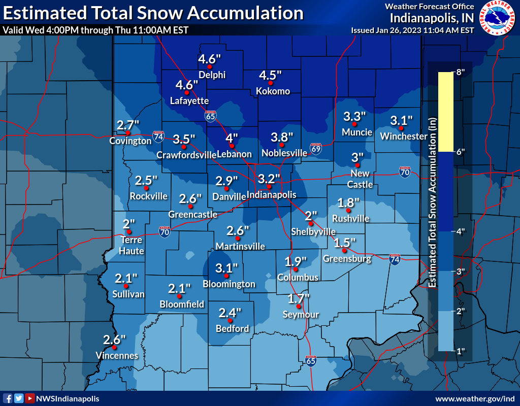
PUBLIC INFORMATION STATEMENT
NATIONAL WEATHER SERVICE INDIANAPOLIS IN
442 PM EST THU JAN 26 2023

...36-HR SNOWFALL AND LIQUID PRECIPITATION TOTALS...
...FROM 700 PM EST 1/24 --TO-- 700 AM EST 1/26....

I. GREATEST SNOWFALL REPORTS FOR EACH COUNTY...IF 4.0+...

 COUNTY       LOCATION                SNOWFALL  SOURCE

 HOWARD       YOUNG AMERICA             6.0 IN  COOP
 TIPPECANOE   WEST LAFAYETTE 3.3 WNW    5.2 IN  AWS
 CARROLL      BURLINGTON                5.0 IN  COCORAHS
 BOONE        LEBANON 4 W               4.5 IN  COCORAHS
 BOONE        PIKE 1.5 ESE              4.5 IN  COCORAHS
 BROWN        SWEETWATER LAKE           4.5 IN  COCORAHS
 RANDOLPH     ALBANY 3.3 ESE            4.5 IN  COCORAHS
 TIPTON       KEMPTON                   4.5 IN  COCORAHS
 TIPTON       TIPTON 5 SW               4.5 IN  COOP
 HAMILTON     CARMEL 1.4 NNE            4.4 IN  COCORAHS
 MONROE       ELLETTSVILLE              4.4 IN  COCORAHS
 MADISON      ANDERSON 4.0 N            4.3 IN  COCORAHS
 CLINTON      KIRLIN 3.4 W              4.0 IN  COCORAHS


II. EVENT TOTAL SNOWFALL REPORTS, BY COUNTY...

CENTRAL INDIANA LOCATION      AMOUNT    TIME/DATE   PROVIDER

...BARTHOLOMEW COUNTY...
TAYLORSVILLE 0.8 SSE          3.0 IN   700AM 01/26  COCORAHS
COLUMBUS                      1.3 IN   700AM 01/26  COOP

...BOONE COUNTY...
LEBANON 6 W                   4.5 IN   700AM 01/26  COOP
PIKE 1.5 ESE                  4.5 IN   700AM 01/26  COCORAHS
ZIONSVILLE                    3.5 IN   700AM 01/26  COCORAHS

...BROWN COUNTY...
SWEETWATER LAKE               4.5 IN   420PM 01/25  PUBLIC
BEANBLOSSOM 1.4 NE            1.8 IN   700AM 01/26  COCORAHS
NEEDMORE 1.7 SSW              1.7 IN   700AM 01/26  COCORAHS

...CARROLL COUNTY...
BURLINGTON                    5.0 IN   700AM 01/26  COCORAHS

...CLAY COUNTY...
CLAY CITY                     1.2 IN   900AM 1/25*  COCORAHS

...CLINTON COUNTY...
KIRLIN 3.4 W                  4.0 IN   700AM 01/26  COCORAHS
FRANKFORT 0.9 SSE             3.7 IN   700AM 01/26  COCORAHS
KILMORE 1.0 ENE               3.5 IN   700AM 01/26  COCORAHS
MULBERRY 0.6 SSE              3.5 IN   700AM 01/26  COCORAHS

...DAVIESS COUNTY...
PLAINVILLE 1.3 S              1.5 IN   700AM 01/26  COCORAHS
WASHINGTON 3.3 SE             1.0 IN   700AM 01/26  COCORAHS

...DECATUR COUNTY...
GREENSBURG 6.0 SW             1.2 IN   700AM 01/26  COCORAHS

...DELAWARE COUNTY...
YORKTOWN 1.2 NNW              3.4 IN   700AM 01/26  COCORAHS
MUNCIE 1.2 SE                 3.1 IN   700AM 01/26  COCORAHS
MACEDONIA                     2.8 IN   700AM 01/26  COCORAHS

...GREENE COUNTY...
OWENSBURG 1.0 N               2.0 IN   700AM 1/25*  COCORAHS

...HAMILTON COUNTY...
CARMEL 1.4 NNE                4.4 IN   700AM 01/26  COCORAHS
FISHERS 4.3 ENE               3.0 IN   700AM 01/26  COCORAHS
NOBLESVILLE 4.4 ESE           3.0 IN   700AM 01/26  COCORAHS
FISHERS 6.1 E                 2.3 IN   700AM 01/26  COCORAHS

...HANCOCK COUNTY...
NEW PALESTINE 1.2 NW          3.0 IN   700AM 01/26  COCORAHS

...HENDRICKS COUNTY...
BROWNSBURG 0.8 NNW            3.6 IN   700AM 01/26  NWS EMPLY
PLAINFIELD 1.1 W              3.0 IN   700AM 01/26  COCORAHS
BROWNSBURG 5.1 NNE            2.9 IN   700AM 01/26  COCORAHS
DANVILLE 3 SW                 2.6 IN   700AM 01/26  COOP

...HENRY COUNTY...
NEW CASTLE 3.2 W              3.0 IN   700AM 01/26  COCORAHS
NEW CASTLE 3 SW               2.4 IN   700AM 01/26  COOP

...HOWARD COUNTY...
YOUNG AMERICA                 6.0 IN   700AM 01/26  COOP
KOKOMO 3 WSW                  5.5 IN   700AM 01/26  COOP

...JENNINGS COUNTY...
SCIPIO 2.2 NNW                3.0 IN   730AM 1/25*  COCORAHS
NORTH VERNON 2 ESE            2.0 IN   500PM 01/25  COOP

...JOHNSON COUNTY...
FRANKLIN 1 W                  2.8 IN   700AM 01/26  NWS EMPLY
FRANKLIN WWTP                 2.4 IN   700AM 01/26  COOP
GREENWOOD 3.8 W               2.3 IN   700AM 01/26  COCORAHS
FRANKLIN 2.0 NW               2.1 IN   700AM 01/26  COCORAHS
GREENWOOD 0.6 ESE             2.0 IN   700AM 01/26  COCORAHS

...KNOX COUNTY...
VINCENNES 4 E                 2.8 IN   700AM 01/26  COOP
BICKNELL                      1.2 IN   700AM 01/26  COCORAHS

...LAWRENCE COUNTY...
HARRODSBURG 2.9 SSW           2.8 IN   700AM 1/25*  COCORAHS
OOLITIC PURDUE EX FARM        2.7 IN   700AM 01/26  COOP
MITCHELL 4.1 E                1.7 IN   700AM 01/26  COCORAHS

...MADISON COUNTY...
ANDERSON 4.0 N                4.3 IN   700AM 01/26  COCORAHS
ANDERSON                      4.0 IN   700AM 01/26  COCORAHS
INGALLS 3.0 WNW               2.1 IN   700AM 01/26  COCORAHS

...MARION COUNTY...
CLERMONT 1.1 N                3.4 IN   700AM 01/26  COCORAHS
CASTLETON 2 S                 3.3 IN   700AM 01/26  COOP
IRVINGTON                     3.2 IN   700AM 01/26  COCORAHS
INDIANAPOLIS INTL AP 1.1 SE   2.9 IN   700AM 01/26  NWS WFO
MERIDIAN-KESSLER              2.5 IN   700AM 01/26  COCORAHS
SPEEDWAY                      2.3 IN   700AM 01/26  COCORAHS
MCCORDSVILLE 1.3 W            2.2 IN   700AM 01/26  COCORAHS
FOUNTAIN SQUARE 1.6 SSW       1.8 IN   700AM 01/26  COCORAHS

...MARTIN COUNTY...
SHOALS 4.0 E                  3.5 IN   700AM 01/26  COCORAHS
SHOALS 8 S                    0.5 IN   700AM 01/26  COOP

...MONROE COUNTY...
ELLETTSVILLE                  4.4 IN   700AM 01/26  COCORAHS
BLOOMINGTON 2.7 E             3.0 IN   800AM 1/25*  COCORAHS
BLOOMINGTON 1.7 NNW           2.8 IN   700AM 01/26  COCORAHS
UNIONVILLE 3.4 SSE            2.0 IN   700AM 01/26  COCORAHS

...MONTGOMERY COUNTY...
CRAWFORDSVILLE 6 SE           3.6 IN   700AM 01/26  COOP
NEW MARKET 2.6 WNW            3.2 IN   700AM 01/26  NWS EMPLY

...MORGAN COUNTY...
BROOKLYN                      3.1 IN   700AM 01/26  NWS EMPLY
MOORESVILLE 1.8 NE            2.7 IN   700AM 01/26  COCORAHS
MARTINSVILLE 2 SW             2.5 IN   700AM 01/26  COOP

...OWEN COUNTY...
ELLETTSVILLE 4.5 W            2.2 IN   700AM 01/26  COCORAHS
SPENCER WWTP                  2.0 IN   700AM 01/26  COOP
FREEMAN 2.4 WSW               1.7 IN   700AM 01/26  COCORAHS

...PUTNAM COUNTY...
CLOVERDALE 3.5 W              2.3 IN   700AM 01/26  COCORAHS

...RANDOLPH COUNTY...
ALBANY 3.3 ESE                4.5 IN   700AM 01/26  COCORAHS
FARMLAND                      2.7 IN   700AM 01/26  COCORAHS
MODOC                         2.0 IN   700AM 01/26  COCORAHS

...RUSH COUNTY...
GWYNNEVILLE 2.2 NNE           1.7 IN   700AM 01/26  COCORAHS

...SHELBY COUNTY...
FAIRLAND 0.9 SSW              2.5 IN   700AM 01/26  COCORAHS
SHELBYVILLE 1.6 SSE           1.5 IN   700AM 01/26  COCORAHS

...SULLIVAN COUNTY...
FARMERSBURG TV-2              2.5 IN  1159PM 01/25  COOP
GRAYSVILLE 5 WNW              2.0 IN   700AM 01/26  COOP
SHAKAMAK STATE PARK           1.8 IN   700AM 1/25*  COOP

...TIPPECANOE COUNTY...
WEST LAFAYETTE 3.3 WNW        5.2 IN   700AM 01/26  COCORAHS
BATTLE GROUND 4.9 WNW         4.5 IN   700AM 01/26  COCORAHS
LAFAYETTE 2.2 NE              3.8 IN   700AM 01/26  COCORAHS
LAFAYETTE 2.2 S               2.8 IN   700AM 01/26  COCORAHS

...TIPTON COUNTY...
KEMPTON                       4.5 IN   700AM 01/26  COCORAHS
TIPTON 5 SW                   4.5 IN   700AM 01/26  COOP

...VERMILLION COUNTY...
PERRYSVILLE 4 WNW             2.3 IN   700AM 01/26  COOP

...VIGO COUNTY...
SHEPARDSVILLE 3.8 SE          1.8 IN   700AM 01/26  COCORAHS

...WARREN COUNTY...
PENCE 1 SW                    2.3 IN   700AM 01/26  COOP


*****************************************************************
*****************************************************************


III. GREATEST LIQUID PRECIPITATION FOR EACH COUNTY...IF 0.85+...

 COUNTY       LOCATION             LIQ PRECIP  SOURCE

 LAWRENCE     MITCHELL 4.1 E          1.44 IN  COCORAHS
 KNOX         BICKNELL                1.15 IN  COCORAHS
 DAVIESS      WASHINGTON 1.5 NW       1.12 IN  COCORAHS
 MONROE       UNIONVILLE 3.2 NNW      1.09 IN  COCORAHS
 MARTIN       SHOALS 8 S              1.07 IN  COOP
 BARTHOLOMEW  TAYLORSVILLE 0.8 SSW    1.06 IN  COCORAHS
 SHELBY       FAIRLAND 0.9 SSW        1.00 IN  COCORAHS
 JENNINGS     SCIPIO 2.2 NNW          0.96 IN  COCORAHS
 SULLIVAN     SHAKAMAK STATE PARK     0.95 IN  COOP
 HENDRICKS    AVON 1.4 SSW            0.91 IN  COCORAHS
 GREENE       OWENSBURG 1.0 N         0.90 IN  COCORAHS
 MARION       SOUTHPORT 0.9 SE        0.89 IN  COCORAHS
 BROWN        BEANBLOSSOM 1.4 NE      0.85 IN  COCORAHS


IV. EVENT TOTAL LIQUID PRECIPITATION REPORTS, BY COUNTY...

CENTRAL INDIANA LOCATION      AMOUNT    TIME/DATE   PROVIDER

...BARTHOLOMEW COUNTY...
TAYLORSVILLE 0.8 SSW         1.06 IN   700AM 01/26  COCORAHS
FLAT ROCK 1.2 SSW            1.04 IN   700AM 01/26  COCORAHS
COLUMBUS 2.1 ENE             1.01 IN   700AM 01/26  COCORAHS
COLUMBUS 3.6 SW              1.00 IN   700AM 01/26  COCORAHS

...BOONE COUNTY...
ZIONSVILLE                   0.76 IN   700AM 01/26  COCORAHS
PIKE 1.5 ESE                 0.68 IN   700AM 01/26  COCORAHS
LEBANON 6 W                  0.62 IN   700AM 01/26  COOP

...BROWN COUNTY...
BEANBLOSSOM 1.4 NE           0.85 IN   700AM 01/26  COCORAHS

...CARROLL COUNTY...
BURLINGTON                   0.66 IN   700AM 01/26  COCORAHS

...CLAY COUNTY...
HOWESVILLE                   0.68 IN   700AM 01/26  COCORAHS
BOWLING GREEN                0.64 IN   700AM 01/26  COCORAHS

...CLINTON COUNTY...
FRANKFORT 0.9 SSE            0.57 IN   700AM 01/26  COCORAHS

...DAVIESS COUNTY...
WASHINGTON 1.5 NW            1.12 IN   700AM 01/26  COCORAHS
WASHINGTON 3.3 SE            1.06 IN   700AM 01/26  COCORAHS
PLAINVILLE 1.3 S             0.93 IN   700AM 01/26  COCORAHS

...DECATUR COUNTY...
GREENSBURG 6.0 SW            0.82 IN   700AM 01/26  COCORAHS

...DELAWARE COUNTY...
YORKTOWN 1.1 NNE             0.58 IN   700AM 01/26  COCORAHS
MUNCIE 1.6 WNW               0.55 IN   700AM 01/26  COCORAHS

...GREENE COUNTY...
OWENSBURG 1.0 N              0.90 IN   700AM 01/26  COCORAHS

...HAMILTON COUNTY...
CARMEL 2.8 NNW               0.75 IN   700AM 01/26  COCORAHS
FISHERS 6.1 E                0.74 IN   700AM 01/26  COCORAHS
FORTVILLE 1.5 NW             0.72 IN   700AM 01/26  COCORAHS
FISHERS 1.1 N                0.70 IN   700AM 01/26  COCORAHS

...HANCOCK COUNTY...
NEW PALESTINE 1.2 NW         0.79 IN   700AM 01/26  COCORAHS
GREENFIELD                   0.69 IN   700AM 01/26  COOP

...HENDRICKS COUNTY...
AVON 1.4 SSW                 0.91 IN   700AM 01/26  COCORAHS
PLAINFILED 1.1 W             0.90 IN   700AM 01/26  COCORAHS
CLAYTON                      0.77 IN   700AM 01/26  COCORAHS
DANVILLE                     0.72 IN   700AM 01/26  COCORAHS

...HENRY COUNTY...
NEW CASTLE 3.9 SW            0.71 IN   700AM 01/26  COCORAHS

...HOWARD COUNTY...
KOKOMO 3 WSW                 0.61 IN   700AM 01/26  COOP
KOKOMO 4.6 ESE               0.53 IN   700AM 01/26  COCORAHS

...JACKSON COUNTY...
SEYMOUR                      1.12 IN   700AM 01/26  MESONET
FREETOWN 1.6 NNE             1.02 IN   700AM 01/26  MESONET

...JENNINGS COUNTY...
SCIPIO 2.2 NNW               0.96 IN   700AM 01/26  COCORAHS
NORTH VERNON 2 ESE           0.90 IN   500PM 01/25  COOP

...JOHNSON COUNTY...
FRANKLIN 1 W                 0.84 IN   700AM 01/26  COOP
GREENWOOD 2.6 W              0.78 IN   700AM 01/26  COCORAHS
FRANKLIN 2.0 NW              0.74 IN   700AM 01/26  COCORAHS

...KNOX COUNTY...
BICKNELL                     1.15 IN   700AM 01/26  COCORAHS
VINCENNES 4 E                0.90 IN   700AM 01/26  COOP

...LAWRENCE COUNTY...
MITCHELL 4.1 E               1.44 IN   700AM 01/26  COCORAHS
BUDDHA                       1.35 IN   700AM 01/26  COCORAHS
BEDFORD 3.7 N                1.10 IN   700AM 01/26  COCORAHS
OOLITIC PURDUE EX FARM       0.98 IN   700AM 01/26  COOP
HARRODSBURG 2.9 SSW          0.88 IN   700AM 01/26  COCORAHS

...MADISON COUNTY...
ANDERSON 2.2 NNE             0.74 IN   700AM 01/26  COCORAHS
INGALLS 3.0 WNW              0.61 IN   700AM 01/26  COCORAHS

...MARION COUNTY...
SOUTHPORT 0.9 SE             0.89 IN   700AM 01/26  COCORAHS
CASTLETON 2 S                0.81 IN   700AM 01/26  COOP
MERIDIAN HILLS               0.81 IN   700AM 01/26  COCORAHS
EAGLE CREEK PARK 2.5 NNW     0.79 IN   700AM 01/26  COCORAHS
IRVINGTON                    0.77 IN   700AM 01/26  COCORAHS
CLERMONT 1.1 N               0.76 IN   700AM 01/26  COCORAHS
MARS HILL                    0.75 IN   700AM 01/26  COCORAHS
FOUNTAIN SQUARE 1.6 SSW      0.70 IN   700AM 01/26  COCORAHS
INDIANAPOLIS INTL AIRPORT    0.69 IN   700AM 01/26  ASOS
MCCORDSVILLE 1.3 W           0.67 IN   700AM 01/26  COCORAHS
MERIDIAN-KESSLER             0.65 IN   700AM 01/26  COCORAHS

...MARTIN COUNTY...
SHOALS 8 S                   1.07 IN   700AM 01/26  COOP
SHOALS 4.0 E                 1.04 IN   700AM 01/26  COCORAHS

...MONROE COUNTY...
UNIONVILLE 3.2 NNW           1.09 IN   700AM 01/26  COCORAHS
UNIONVILLE 3.4 SSE           1.09 IN   700AM 01/26  COCORAHS
ELLETTSVILLE 1.8 SSW         1.00 IN   700AM 01/26  COCORAHS
BLOOMINGTON 1.7 NNW          0.92 IN   700AM 01/26  COCORAHS

...MONTGOMERY COUNTY...
CRAWFORDSVILLE 6 SE          0.56 IN   700AM 01/26  COOP
LADOGA 3.4 E                 0.55 IN   700AM 01/26  COCORAHS
NEW MARKET 2.4 WNW           0.52 IN   700AM 01/26  NWS EMPLY

...MORGAN COUNTY...
MARTINSVILLE 3.9 ESE         0.91 IN   700AM 01/26  COCORAHS
PARAGON 3.3 SSW              0.89 IN   700AM 01/26  COCORAHS
MARTINSVILLE 2 SW            0.78 IN   700AM 01/26  COOP
BROOKLYN                     0.68 IN   700AM 01/26  NWS EMPLY

...OWEN COUNTY...
FREEMAN 2.4 WSW              0.92 IN   700AM 01/26  COCORAHS
SPENCER 2.1 NNE              0.86 IN   700AM 01/26  COCORAHS
ELLETTSVILLE 4.6 W           0.81 IN   700AM 01/26  COCORAHS

...PARKE COUNTY...
ROCKVILLE FIRE               0.50 IN   530PM 01/25  COOP

...PUTNAM COUNTY...
CLOVERDALE 3.5 W             0.75 IN   700AM 01/26  COCORAHS

...RANDOLPH COUNTY...
FARMLAND                     0.70 IN   700AM 01/26  COCORAHS
WINCHESTER 2.2 WSW           0.70 IN   700AM 01/26  COCORAHS
UNION CITY 3.6 WSW           0.66 IN   910AM 01/26  COCORAHS

...RUSH COUNTY...
HOMER                        0.83 IN   700AM 01/26  COCORAHS
RUSHVILLE 0.7 ENE            0.81 IN   700AM 01/26  COCORAHS

...SHELBY COUNTY...
FAIRLAND 0.9 SSW             1.00 IN   700AM 01/26  COCORAHS
SHELBYVILLE 1.6 SSE          0.78 IN   700AM 01/26  COCORAHS
SHELBYVILLE 7.1 WSW          0.73 IN   700AM 01/26  COCORAHS

...SULLIVAN COUNTY...
SHAKAMAK STATE PARK          0.95 IN   700AM 01/26  COOP
SULLIVAN 1 WSW               0.85 IN   700AM 01/26  MESONET
HYMERA                       0.77 IN   700AM 01/26  COCORAHS

...TIPPECANOE COUNTY...
WEST LAFAYETTE 3.3 WNW       0.60 IN   700AM 01/26  COCORAHS
OTTERBEIN 2.3 SE             0.59 IN   700AM 01/26  COCORAHS
BATTLE GROUND 4.9 WNW        0.52 IN   700AM 01/26  COCORAHS

...TIPTON COUNTY...
TIPTON 5 SW                  0.63 IN   700AM 01/26  COOP

...VIGO COUNTY...
SHEPARDSVILLE 3.8 SE         0.81 IN   700AM 01/26  COCORAHS
SEELYVILLE 3.2 S             0.72 IN   700AM 01/26  COCORAHS
RILEY                        0.66 IN   700AM 01/26  COCORAHS


OBSERVATIONS ARE COLLECTED FROM A VARIETY OF SOURCES WITH VARYING
EQUIPMENT AND EXPOSURES. WE THANK ALL VOLUNTEER WEATHER OBSERVERS
FOR THEIR DEDICATION. NOT ALL DATA LISTED ARE CONSIDERED OFFICIAL.

AGM
 |
Media use of NWS Web News Stories is encouraged! Please acknowledge the NWS as the source of any news information accessed from this site. |
|

