Overview
A large synoptic system brought the largest snow event in 3 years to much of central Indiana starting late on February 14 and continuing into early on February 16. Two day snowfall amounts ranged from 8 to 12 inches across the area. Heavy snow at times reduced visibility to around one quarter of a mile. Gusty winds caused blowing and drifting snow, which lead to drifts measured in feet.Snow/Ice
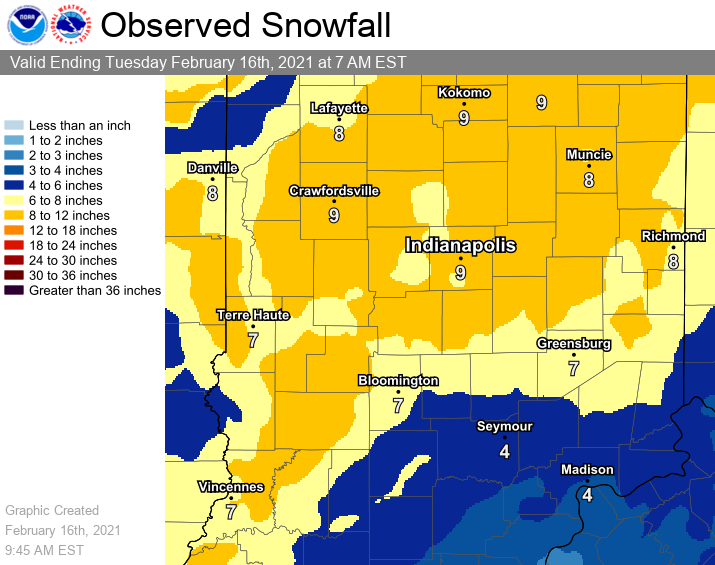
Up to near a foot of snow fell in some locations of central Indiana. Some dry air
PUBLIC INFORMATION STATEMENT NATIONAL WEATHER SERVICE INDIANAPOLIS IN 1029 AM EST TUE FEB 16 2021 ...2 DAY SNOWFALL REPORTS FOR FEBRUARY 14TH/15TH WINTER STORM... LOCATION AMOUNT TIME/DATE PROVIDER ...INDIANA... ...BARTHOLOMEW COUNTY... COLUMBUS 3.8 SW 6.0 IN 0928 AM 02/16 COCORAHS HOPE 5.2 NW 6.0 IN 0800 AM 02/16 COCORAHS 2 NE COLUMBUS 5.5 IN 0700 AM 02/16 COCORAHS (WD9HTN)COLUMBUS 2.2 NE 5.5 IN 0700 AM 02/16 COCORAHS ...BOONE COUNTY... LEBANON 6 W 9.2 IN 0700 AM 02/16 COOP LEBANON 4.4 W 9.2 IN 0700 AM 02/16 COCORAHS 1.6 E JAMESTOWN 8.8 IN 0700 AM 02/16 COOP JAMESTOWN 1.6 E 8.8 IN 0700 AM 02/16 COCORAHS 5 W LEBANON 8.0 IN 0700 AM 02/16 COCORAHS 5 NE ADVANCE 8.0 IN 0700 AM 02/16 CO-OP OBSERVER LEBANON 4.4 W 8.0 IN 0700 AM 02/16 COCORAHS LEBANON 6 W 8.0 IN 0700 AM 02/16 COOP JAMESTOWN 1.6 E 7.3 IN 0700 AM 02/16 COCORAHS ...BROWN COUNTY... NASHVILLE 7.8 SE 5.6 IN 0725 AM 02/16 COCORAHS 2 ENE STONE HEAD 4.8 IN 0725 AM 02/16 COCORAHS ...CARROLL COUNTY... (K9EFY)FLORA 0.3 S 10.5 IN 0700 AM 02/16 COCORAHS FLORA 9.0 IN 0700 AM 02/16 COOP ...CLAY COUNTY... 2.7 SW POLAND 8.7 IN 0700 AM 02/16 COOP JASONVILLE 4.0 ENE 8.0 IN 0845 AM 02/16 COCORAHS 3 SSW POLAND 8.0 IN 0700 AM 02/16 CO-OP OBSERVER 2.7 SW POLAND 8.0 IN 0700 AM 02/16 COOP POLAND 8.0 IN 0736 PM 02/15 PUBLIC ...CLINTON COUNTY... FRANKFORT 5.0 IN 0531 PM 02/15 PUBLIC ...DAVIESS COUNTY... WASHINGTON 1.5 NW 9.9 IN 0700 AM 02/16 COCORAHS 2 NNW WASHINGTON 8.7 IN 0700 AM 02/16 COCORAHS 1 SSE WASHINGTON 7.0 IN 1014 PM 02/15 PUBLIC WASHINGTON 3.3 SE 6.2 IN 0700 AM 02/16 COCORAHS 3 SE WASHINGTON 5.0 IN 0700 AM 02/16 COCORAHS ...DECATUR COUNTY... 1 SE CLARKSBURG 10.3 IN 0345 AM 02/16 PUBLIC 1 NW LAKE SANTEE 10.3 IN 0345 AM 02/16 GREENSBURG 8.0 IN 0734 PM 02/15 PUBLIC ...DELAWARE COUNTY... (K9CJC) SPRINGPORT 3.5 NE 10.5 IN 0700 AM 02/16 COCORAHS (KC9RVL) YORKTOWN 1.2 NNW 10.0 IN 0700 AM 02/16 COCORAHS YORKTOWN 1.1 NNW 10.0 IN 0700 AM 02/16 COCORAHS 2 ENE OAKVILLE 9.5 IN 0700 AM 02/16 COCORAHS (K9CJC) SPRINGPORT 3.5 NE 9.5 IN 0700 AM 02/16 COCORAHS 1 NNW YORKTOWN 9.0 IN 0700 AM 02/16 COCORAHS YORKTOWN 1.1 NNW 9.0 IN 0700 AM 02/16 COCORAHS MUNCIE 1.2 SE 9.0 IN 0545 AM 02/16 COCORAHS 1 ESE MUNCIE 9.0 IN 0545 AM 02/16 COCORAHS 1 WSW BALL STATE UNIVERSITY 8.2 IN 0832 AM 02/16 TRAINED SPOTTER ...FOUNTAIN COUNTY... COVINGTON 10.0 IN 1010 AM 02/16 EMERGENCY MNGR VEEDERSBURG 9.0 IN 1046 PM 02/15 PUBLIC ...GREENE COUNTY... BLOOMFIELD 9.0 IN 0800 AM 02/16 COOP SPRINGVILLE 6.0 W 8.0 IN 0927 AM 02/16 COCORAHS SPRINGVILLE 6.0 W 7.0 IN 0927 AM 02/16 COCORAHS 1 N OWENSBURG 7.0 IN 0927 AM 02/16 COCORAHS LINTON 7.0 IN 0733 PM 02/15 PUBLIC LYONS 6.5 IN 0732 PM 02/15 PUBLIC ...HAMILTON COUNTY... CARMEL 1.5 W 10.0 IN 0800 AM 02/16 COCORAHS FISHERS 3.0 NE 9.9 IN 0900 AM 02/16 COCORAHS WESTFIELD 1.4 ESE 9.5 IN 0800 AM 02/16 COCORAHS MCCORDSVILLE 2.6 NE 9.3 IN 0700 AM 02/16 COCORAHS CARMEL 2.8 NE 9.0 IN 0700 AM 02/16 COCORAHS 3 NE FISHERS 8.8 IN 0900 AM 02/16 COCORAHS FISHERS 3.0 NE 8.8 IN 0900 AM 02/16 COCORAHS NOBLESVILLE 8.5 IN 0901 PM 02/15 PUBLIC WESTFIELD 8.5 IN 0900 PM 02/15 PUBLIC 3 NE MCCORDSVILLE 8.2 IN 0700 AM 02/16 COCORAHS MCCORDSVILLE 2.6 NE 8.2 IN 0700 AM 02/16 COCORAHS CARMEL 1.5 W 8.0 IN 0800 AM 02/16 COCORAHS 2 W CARMEL 8.0 IN 0800 AM 02/16 COCORAHS 3 NE CARMEL 8.0 IN 0700 AM 02/16 COCORAHS CARMEL 2.8 NE 8.0 IN 0700 AM 02/16 COCORAHS 2 NW FISHERS 8.0 IN 0953 PM 02/15 AMATEUR RADIO 3 SW NOBLESVILLE 8.0 IN 0950 PM 02/15 AMATEUR RADIO 1 ESE WESTFIELD 7.5 IN 0800 AM 02/16 COCORAHS WESTFIELD 1.4 ESE 7.5 IN 0800 AM 02/16 COCORAHS SHERIDAN 7.5 IN 0505 AM 02/16 PUBLIC 3 SSW MORSE RESERVOIR 7.4 IN 1037 PM 02/15 TRAINED SPOTTER WESTFIELD 7.0 IN 0653 PM 02/15 PUBLIC FISHERS 1.1 N 6.8 IN 0700 AM 02/16 COCORAHS ...HANCOCK COUNTY... (N9MRC)WILKINSON 4.1 W 7.8 IN 0700 AM 02/16 COCORAHS 4 W WILKINSON 7.0 IN 0700 AM 02/16 COCORAHS (N9MRC)WILKINSON 4.1 W 7.0 IN 0700 AM 02/16 COCORAHS 1.2 SE GREENFIELD 6.8 IN 0800 AM 02/16 COOP 1 SE GREENFIELD 6.0 IN 0800 AM 02/16 CO-OP OBSERVER 2 W GREENFIELD 6.0 IN 0505 PM 02/15 PUBLIC ...HENDRICKS COUNTY... 2 SSW AVON 8.3 IN 0852 PM 02/15 PUBLIC 2 NNW PLAINFIELD 8.3 IN 0852 PM 02/15 PUBLIC BROWNSBURG 0.8 NNW 8.0 IN 0630 AM 02/16 COCORAHS BROWNSBURG 4.6 S 8.0 IN 0600 AM 02/16 COCORAHS 2 ESE JAMESTOWN 7.3 IN 0700 AM 02/16 COCORAHS BROWNSBURG 0.8 NNW 6.2 IN 0630 AM 02/16 COCORAHS 1 NNW BROWNSBURG 6.2 IN 0630 AM 02/16 COCORAHS 1 WNW AVON 6.2 IN 0600 AM 02/16 COCORAHS BROWNSBURG 4.6 S 6.2 IN 0600 AM 02/16 COCORAHS AVON 6.0 IN 0531 PM 02/15 PUBLIC AVON 5.5 IN 0645 PM 02/15 PUBLIC ...HENRY COUNTY... 2.4 SW NEW CASTLE 9.9 IN 0700 AM 02/16 COOP NEW CASTLE 2.4 SW 9.9 IN 0700 AM 02/16 COCORAHS 3 SW NEW CASTLE 9.0 IN 0700 AM 02/16 COCORAHS NEW CASTLE 2.4 SW 9.0 IN 0700 AM 02/16 COCORAHS NEW CASTLE 3.2 W 8.5 IN 0700 AM 02/16 COCORAHS 3 W NEW CASTLE 7.9 IN 0700 AM 02/16 COCORAHS NEW CASTLE 3.2 W 7.9 IN 0700 AM 02/16 COCORAHS 2 NW STRAUGHN 7.5 IN 0805 PM 02/15 AMATEUR RADIO ...HOWARD COUNTY... (KC9IYD)KOKOMO 4.0 WNW 9.1 IN 0700 AM 02/16 COCORAHS 4 WNW KOKOMO 7.5 IN 0700 AM 02/16 COCORAHS 2 N RUSSIAVILLE 7.0 IN 1047 PM 02/15 PUBLIC KOKOMO 7.0 IN 0926 PM 02/15 PUBLIC ...JACKSON COUNTY... BROWNSTOWN 9.0 IN 0930 PM 02/15 EMERGENCY MNGR ...JOHNSON COUNTY... 1.8 SE FRANKLIN 11.8 IN 0700 AM 02/16 COOP BARGERSVILLE 11.0 IN 1115 PM 02/15 TRAINED SPOTTER 2 SSE FRANKLIN 10.8 IN 0700 AM 02/16 CO-OP OBSERVER 1.8 SE FRANKLIN 10.8 IN 0700 AM 02/16 COOP GREENWOOD 5.0 W 10.5 IN 0800 AM 02/16 COCORAHS GREENWOOD 0.6 ESE 10.0 IN 0830 AM 02/16 COCORAHS 1 ESE GREENWOOD 10.0 IN 0830 AM 02/16 COCORAHS GREENWOOD 2.6 W 9.6 IN 0700 AM 02/16 COCORAHS 5 W GREENWOOD 9.5 IN 0800 AM 02/16 COCORAHS GREENWOOD 5.0 W 9.5 IN 0800 AM 02/16 COCORAHS 3 NNW BARGERSVILLE 9.5 IN 1010 PM 02/15 PUBLIC FRANKLIN 1 W 8.8 IN 0700 AM 02/16 COOP 2 W GREENWOOD 8.4 IN 0700 AM 02/16 COCORAHS GREENWOOD 2.6 W 8.4 IN 0700 AM 02/16 COCORAHS GREENWOOD 8.0 IN 0814 PM 02/15 PUBLIC 1 ENE WAVERLY 8.0 IN 0801 PM 02/15 PUBLIC FRANKLIN 8.0 IN 0732 PM 02/15 PUBLIC 3 NNW BARGERSVILLE 8.0 IN 0731 PM 02/15 PUBLIC GREENWOOD 3.8 W 7.9 IN 0643 AM 02/16 COCORAHS 4 W GREENWOOD 7.7 IN 0643 AM 02/16 COCORAHS GREENWOOD 3.8 W 7.7 IN 0643 AM 02/16 COCORAHS 1 WSW FRANKLIN 7.5 IN 0700 AM 02/16 CO-OP OBSERVER FRANKLIN 1 W 7.5 IN 0700 AM 02/16 COOP 4 NE WAVERLY 6.0 IN 0755 PM 02/15 PUBLIC FRANKLIN 6.0 IN 0754 PM 02/15 PUBLIC ...KNOX COUNTY... OAKTOWN 10.0 IN 1031 PM 02/15 PUBLIC 2 ENE VINCENNES 8.0 IN 0526 PM 02/15 CO-OP OBSERVER 2 ENE VINCENNES 8.0 IN 0526 PM 02/15 CO-OP OBSERVER VINCENNES 4 E 6.9 IN 0700 AM 02/16 COOP ...LAWRENCE COUNTY... 4 E SILVERVILLE 11.0 IN 1002 PM 02/15 PUBLIC BEDFORD 8.6 NNW 6.5 IN 0845 AM 02/16 COCORAHS 3 SSW HARRODSBURG 6.5 IN 0845 AM 02/16 COCORAHS BEDFORD 6.5 SE 6.0 IN 0730 AM 02/16 COCORAHS MITCHELL 4.1 E 6.0 IN 0730 AM 02/16 COCORAHS BEDFORD 6.5 SE 5.0 IN 0730 AM 02/16 COCORAHS 2 NNE TUNNELTON 5.0 IN 0730 AM 02/16 COCORAHS 1.7 S AVOCA 4.6 IN 0700 AM 02/16 COOP MITCHELL 4.1 E 4.5 IN 0730 AM 02/16 COCORAHS 1 ESE SPRING MILL STATE PARK 4.5 IN 0730 AM 02/16 COCORAHS 4 WSW OOLITIC 4.5 IN 0552 PM 02/15 PUBLIC 1 W OOLITIC 4.0 IN 0700 AM 02/16 CO-OP OBSERVER ...MADISON COUNTY... ANDERSON 4.0 N 9.5 IN 0700 AM 02/16 COCORAHS 2 N COUNTRY CLUB HEIGHTS 9.0 IN 0805 PM 02/15 TRAINED SPOTTER 2 N COUNTRY CLUB HEIGHTS 8.5 IN 0700 AM 02/16 COCORAHS ANDERSON 2.0 S 8.5 IN 0700 AM 02/16 COCORAHS ANDERSON 4.0 N 8.5 IN 0700 AM 02/16 COCORAHS ALEXANDRIA 8.0 IN 0525 AM 02/16 PUBLIC 2 S ANDERSON 7.6 IN 0700 AM 02/16 COCORAHS 2 S ANDERSON 6.2 IN 0735 PM 02/15 PUBLIC 2 N COUNTRY CLUB HEIGHTS 6.0 IN 0800 PM 02/15 TRAINED SPOTTER ...MARION COUNTY... INDIANAPOLIS 9.8 WNW 10.7 IN 0700 AM 02/16 COCORAHS INDIANAPOLIS 10.9 NW 10.6 IN 0800 AM 02/16 COCORAHS 1 ESE GEIST RESERVOIR 10.0 IN 0926 AM 02/16 PUBLIC 1 WSW MCCORDSVILLE 10.0 IN 0926 AM 02/16 1 E WARREN PARK 10.0 IN 0600 AM 02/16 COCORAHS INDIANAPOLIS 6.2 E 10.0 IN 0600 AM 02/16 COCORAHS 1 N CLERMONT 9.7 IN 0700 AM 02/16 COCORAHS INDIANAPOLIS 9.8 WNW 9.7 IN 0700 AM 02/16 COCORAHS INDIANAPOLIS 6.7 N 9.0 IN 0700 AM 02/16 COCORAHS MCCORDSVILLE 1.3 W 9.0 IN 0700 AM 02/16 COCORAHS SPEEDWAY 8.9 IN 1117 PM 02/15 PUBLIC 1 NW HOMECROFT 8.4 IN 1118 PM 02/15 PUBLIC 1 SE INDIANAPOLIS INTL AIRP 8.1 IN 0700 AM 02/16 OFFICIAL NWS OBS SPEEDWAY 6.2 SSW 8.1 IN 0700 AM 02/16 COCORAHS 1 WNW BROAD RIPPLE 8.1 IN 0700 AM 02/16 COCORAHS INDIANAPOLIS 6.7 N 8.1 IN 0700 AM 02/16 COCORAHS 1 SSE INDIANAPOLIS INTL AIR 8.1 IN 0700 AM 02/16 OFFICIAL NWS OBS INDIANAPOLIS 5.1 N 8.0 IN 0900 AM 02/16 COCORAHS INDIANAPOLIS 5.8 NNE 8.0 IN 0800 AM 02/16 COCORAHS 1 E GEIST RESERVOIR 8.0 IN 0700 AM 02/16 COCORAHS INDIANAPOLIS 3.2 S 7.9 IN 0700 AM 02/16 COCORAHS 1 SW WARREN PARK 7.6 IN 0940 PM 02/15 PUBLIC CASTLETON 2S 7.2 IN 0700 AM 02/16 COOP 2 S CASTLETON 7.2 IN 0700 AM 02/16 CO-OP OBSERVER INDIANAPOLIS 9.2 NNE 7.0 IN 0810 AM 02/16 COCORAHS 1 SSE NORA 7.0 IN 0810 AM 02/16 COCORAHS 3 S MONUMENT CIRCLE 7.0 IN 0700 AM 02/16 COCORAHS INDIANAPOLIS 3.2 S 7.0 IN 0700 AM 02/16 COCORAHS 3 W MONUMENT CIRCLE 7.0 IN 1040 PM 02/15 PUBLIC 1 ENE NORA 7.0 IN 1027 PM 02/15 PUBLIC 2 SSE EAGLE CREEK RESERVOIR 7.0 IN 0752 PM 02/15 PUBLIC 1 ESE INDIANAPOLIS INTL AIR 7.0 IN 0739 PM 02/15 PUBLIC INDIANAPOLIS 7.8 N 6.9 IN 0615 AM 02/16 COCORAHS BEECH GROVE 6.8 IN 1012 PM 02/15 PUBLIC INDIANAPOLIS 5.8 NNE 6.7 IN 0800 AM 02/16 COCORAHS 2 ESE BROAD RIPPLE 6.7 IN 0800 AM 02/16 COCORAHS 1 WNW MERIDIAN HILLS 6.1 IN 0615 AM 02/16 COCORAHS INDIANAPOLIS 7.8 N 6.1 IN 0615 AM 02/16 COCORAHS 2 SE GEIST RESERVOIR 6.0 IN 0920 PM 02/15 PUBLIC SPEEDWAY 5.5 IN 0701 PM 02/15 PUBLIC ...MARTIN COUNTY... LOOGOOTEE 8.5 IN 0732 PM 02/15 PUBLIC ...MONROE COUNTY... 1 S ELLETTSVILLE 9.0 IN 1006 AM 02/16 (KC9RPX)ELLETTSVILLE 0.5 W 8.5 IN 0700 AM 02/16 COCORAHS 4 W UNIONVILLE 7.5 IN 1033 PM 02/15 PUBLIC ELLETTSVILLE 7.0 IN 0700 AM 02/16 COCORAHS 1 N INDIANA UNIVERSITY 6.5 IN 0640 PM 02/15 PUBLIC 5 W UNIONVILLE 3.0 IN 0422 PM 02/15 PUBLIC ...MONTGOMERY COUNTY... CRAWFORDSVILLE 9.0 IN 0731 PM 02/15 PUBLIC WAVELAND 8.0 IN 0842 PM 02/15 PUBLIC ...MORGAN COUNTY... MOORESVILLE 3.8 NE 9.5 IN 0700 AM 02/16 COCORAHS MARTINSVILLE 9.0 IN 0732 PM 02/15 PUBLIC 1 ENE MOORESVILLE 8.4 IN 0700 AM 02/16 COCORAHS MOORESVILLE 3.8 NE 8.4 IN 0700 AM 02/16 COCORAHS BROOKLYN 0.5 ENE 8.3 IN 0600 AM 02/16 COCORAHS 1 ESE BROOKLYN 8.3 IN 0600 AM 02/16 COCORAHS MOORESVILLE 8.0 IN 0802 PM 02/15 PUBLIC MARTINSVILLE 2.3 SE 7.6 IN 0700 AM 02/16 COCORAHS (N9JPX)PARAGON 3.2 ENE 7.0 IN 0700 AM 02/16 COCORAHS 3 NW WAVERLY 7.0 IN 1017 PM 02/15 TRAINED SPOTTER 3 NNW WAVERLY 7.0 IN 1017 PM 02/15 TRAINED SPOTTER 2 SE MARTINSVILLE 6.5 IN 0700 AM 02/16 COCORAHS MARTINSVILLE 2.3 SE 6.5 IN 0700 AM 02/16 COCORAHS 4 ENE PARAGON 6.0 IN 0700 AM 02/16 COCORAHS (N9JPX)PARAGON 3.2 ENE 6.0 IN 0700 AM 02/16 COCORAHS 1 SSW CAMBY 6.0 IN 0900 PM 02/15 NWS EMPLOYEE ...OWEN COUNTY... SPENCER 10.0 IN 0700 AM 02/16 COOP SPENCER 9.0 IN 0700 AM 02/16 CO-OP OBSERVER SPENCER 7.0 S 8.0 IN 0700 AM 02/16 COCORAHS 5 S DEVORE 8.0 IN 1100 PM 02/15 TRAINED SPOTTER 4 S DEVORE 8.0 IN 1100 PM 02/15 PUBLIC 5 ESE FREEDOM 7.0 IN 0700 AM 02/16 COCORAHS SPENCER 7.0 S 7.0 IN 0700 AM 02/16 COCORAHS ...PARKE COUNTY... ROCKVILLE 3.6 ENE 8.0 IN 0700 AM 02/16 COCORAHS 1 ESE CLINTON 7.5 IN 0759 PM 02/15 PUBLIC 1 E CLINTON 7.5 IN 0759 PM 02/15 PUBLIC 2 SW JUDSON 7.0 IN 0700 AM 02/16 COCORAHS ROCKVILLE 3.6 ENE 7.0 IN 0700 AM 02/16 COCORAHS ROCKVILLE 7.0 IN 0732 PM 02/15 PUBLIC 1 N BLOOMINGDALE 6.8 IN 0616 PM 02/15 PUBLIC BLOOMINGDALE 6.8 IN 0616 PM 02/15 PUBLIC 3 WNW CECIL HARDEN LAKE 6.3 IN 0700 PM 02/15 PUBLIC ...PUTNAM COUNTY... CLOVERDALE 3.5 W 6.9 IN 0700 AM 02/16 COCORAHS GREENCASTLE 6.5 IN 1000 PM 02/15 PUBLIC 3 W CLOVERDALE 6.1 IN 0700 AM 02/16 COCORAHS CLOVERDALE 3.5 W 6.1 IN 0700 AM 02/16 COCORAHS ...RANDOLPH COUNTY... (KC9FXU) WINCHESTER 2.2 WSW 7.8 IN 0700 AM 02/16 COCORAHS 2 WSW WINCHESTER 7.0 IN 0700 AM 02/16 COCORAHS ...RUSH COUNTY... 0.8 SW RUSHVILLE 9.5 IN 0700 AM 02/16 COOP 4 ENE MORRISTOWN 8.5 IN 0800 AM 02/16 COCORAHS RUSHVILLE 8.0 IN 0700 AM 02/16 EMERGENCY MANAGER 1 S RUSHVILLE 7.5 IN 0700 AM 02/16 CO-OP OBSERVER 0.8 SW RUSHVILLE 7.5 IN 0700 AM 02/16 COOP HOMER 0.4 NE 7.4 IN 0700 AM 02/16 COCORAHS 2 S ARLINGTON 7.0 IN 0700 AM 02/16 COCORAHS 1 NE RUSHVILLE 7.0 IN 1000 PM 02/15 AMATEUR RADIO 1 ENE RUSHVILLE 7.0 IN 1000 PM 02/15 AMATEUR RADIO 1 NE RUSHVILLE 4.5 IN 0505 PM 02/15 AMATEUR RADIO ...SHELBY COUNTY... (KB9RBB)FAIRLAND 0.9 SSW 10.0 IN 0700 AM 02/16 COCORAHS 2 SSW SHELBYVILLE 9.6 IN 0835 AM 02/16 PUBLIC MORRISTOWN 3.8 ENE 9.5 IN 0800 AM 02/16 COCORAHS MORRISTOWN 8.1 IN 0700 AM 02/16 COOP 1 SW FAIRLAND 8.0 IN 0700 AM 02/16 COCORAHS 1 WSW MORRISTOWN 7.8 IN 0700 AM 02/16 CO-OP OBSERVER MORRISTOWN 7.8 IN 0700 AM 02/16 COOP 1 SSW FLAT ROCK 6.0 IN 0800 AM 02/16 COCORAHS ...SULLIVAN COUNTY... GRAYSVILLE 5 WNW 10.0 IN 0800 AM 02/16 COOP HYMERA 0.4 W 6.8 IN 0800 AM 02/16 COCORAHS 1 SW FARMERSBURG 5.5 IN 0615 PM 02/15 CO-OP OBSERVER ...TIPPECANOE COUNTY... LAFAYETTE 5 S 11.0 IN 0800 AM 02/16 COOP LAFAYETTE 2.2 S 9.0 IN 0700 AM 02/16 COCORAHS 1 SE PURDUE UNIVERSITY 8.5 IN 1048 AM 02/15 PUBLIC WEST LAFAYETTE 8.0 IN 0812 PM 02/15 PUBLIC 2 S LAFAYETTE 7.5 IN 0700 AM 02/16 COCORAHS LAFAYETTE 2.2 S 7.5 IN 0700 AM 02/16 COCORAHS LAFAYETTE 2.2 NE 7.0 IN 0700 AM 02/16 COCORAHS 3 NE LAFAYETTE 5.7 IN 0700 AM 02/16 COCORAHS ...TIPTON COUNTY... (K9WKK)TIPTON 1.3 NW 11.0 IN 0700 AM 02/16 COCORAHS 5.1 SE GOLDSMITH 8.5 IN 0545 AM 02/16 COOP 4 W ATLANTA 8.5 IN 0545 AM 02/16 CO-OP OBSERVER TIPTON 6.5 IN 0844 PM 02/15 PUBLIC ...WARREN... 3.0 E STATE LINE CITY 10.0 IN 0700 AM 2/16 PUBLIC ...VERMILLION COUNTY... CLINTON 7.0 IN 0745 PM 02/15 PUBLIC 0.7 SW GESSIE 5.0 IN 0610 AM 02/16 COOP ...VIGO COUNTY... TERRE HAUTE 6.5 N 9.1 IN 0700 AM 02/16 COCORAHS 1 SE TERRE HAUTE 8.5 IN 0800 AM 02/16 AMATEUR RADIO 1 NNW NORTH TERRE HAUTE 7.8 IN 0700 AM 02/16 COCORAHS TERRE HAUTE 6.5 N 7.8 IN 0700 AM 02/16 COCORAHS 2 E TERRE HAUTE 6.5 IN 0950 PM 02/15 PUBLIC TERRE HAUTE 6.0 IN 0700 PM 02/15 PUBLIC OBSERVATIONS ARE COLLECTED FROM A VARIETY OF SOURCES WITH VARYING EQUIPMENT AND EXPOSURES. WE THANK ALL VOLUNTEER WEATHER OBSERVERS FOR THEIR DEDICATION. NOT ALL DATA LISTED ARE CONSIDERED OFFICIAL.
Photos & Video
 |
 |
|
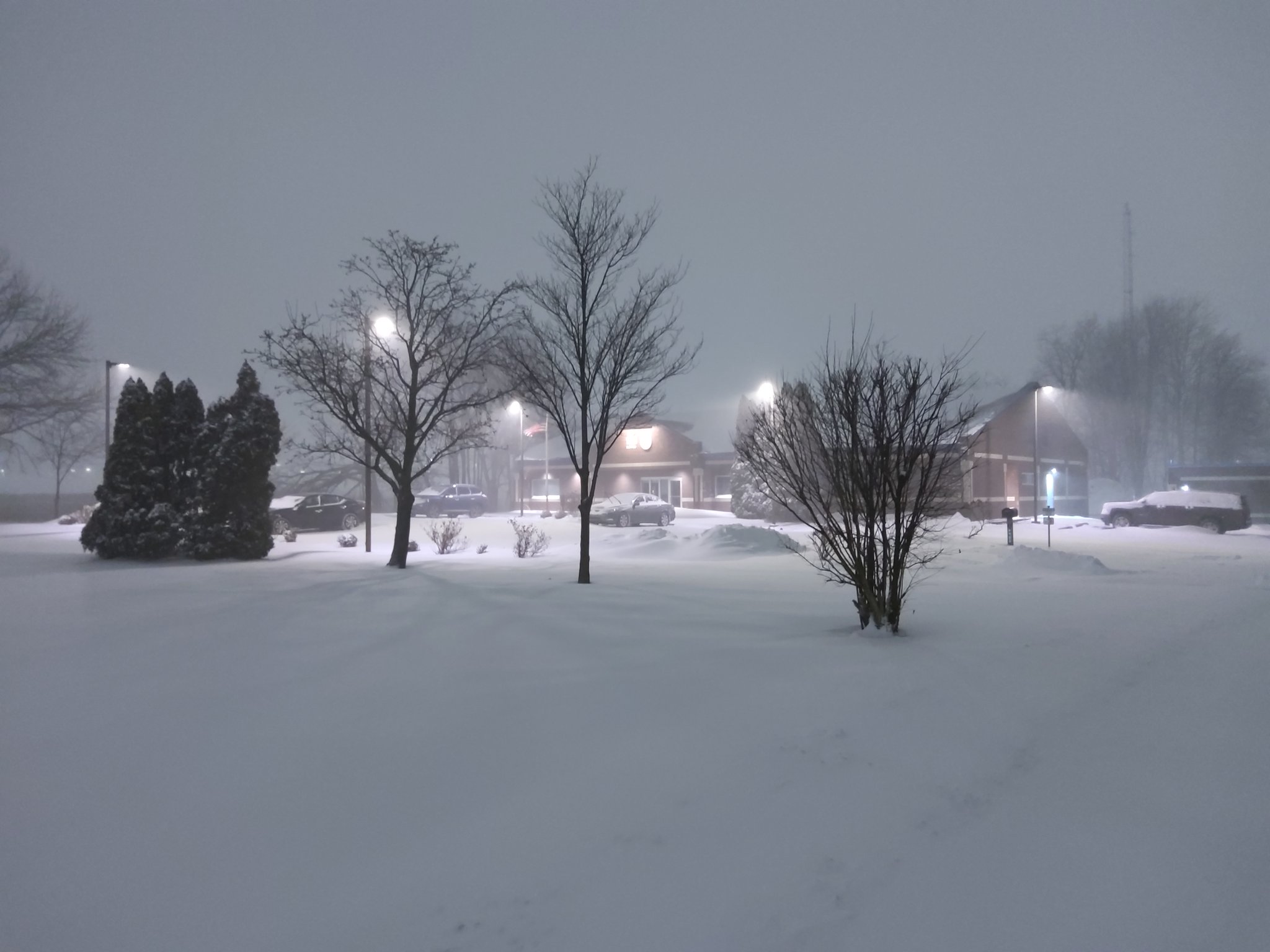
Snow at the NWS WFO in Indianapolis 2/15 |
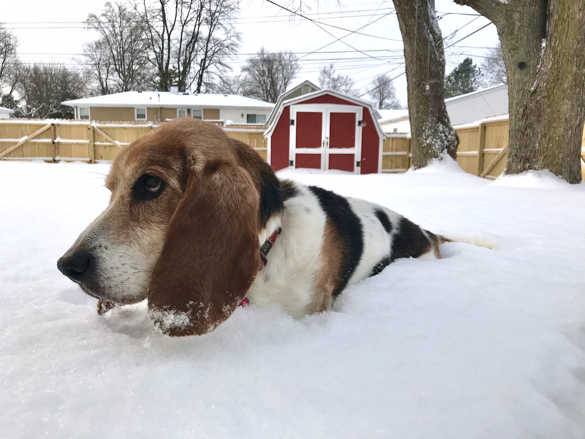
Snow measured approximately 2/3 of a Basset Hound on the south side of Indianapolis |
Storm Reports
...24 HOUR SNOWFALL REPORTS FOR 2/16...

LOCATION                     AMOUNT    TIME/DATE       PROVIDER

...INDIANA...

...BARTHOLOMEW COUNTY...
HOPE 5.2 NW                  6.0 IN    0800 AM 02/16   COCORAHS
(WD9HTN)COLUMBUS 2.2 NE      5.5 IN    0700 AM 02/16   COCORAHS
COLUMBUS                     4.5 IN    0645 PM 02/15   PUBLIC

...BOONE COUNTY...
LEBANON 4.4 W                8.0 IN    0700 AM 02/16   COCORAHS
LEBANON 6 W                  8.0 IN    0700 AM 02/16   COOP
JAMESTOWN 1.6 E              7.3 IN    0700 AM 02/16   COCORAHS
ZIONSVILLE                   7.0 IN    0755 PM 02/15   PUBLIC

...BROWN COUNTY...
NASHVILLE 7.8 SE             4.8 IN    0725 AM 02/16   COCORAHS

...CARROLL COUNTY...
FLORA                        8.0 IN    0700 AM 02/16   COOP

...CLAY COUNTY...
2.7 SW POLAND                8.0 IN    0700 AM 02/16   COOP
POLAND                       8.0 IN    0736 PM 02/15   PUBLIC
JASONVILLE 4.0 ENE           7.0 IN    0845 AM 02/16   COCORAHS
BRAZIL                       5.0 IN    0723 PM 02/15   PUBLIC

...CLINTON COUNTY...
FRANKFORT                    5.0 IN    0531 PM 02/15   PUBLIC

...DAVIESS COUNTY...
WASHINGTON 1.5 NW            8.7 IN    0700 AM 02/16   COCORAHS
WASHINGTON                   7.0 IN    1014 PM 02/15   PUBLIC
WASHINGTON 3.3 SE            5.0 IN    0700 AM 02/16   COCORAHS

...DECATUR COUNTY...
1 NW LAKE SANTEE             10.3 IN   0345 AM 02/16
0.6 NW GREENSBURG            2.5 IN    1200 AM 02/16   COOP

...DELAWARE COUNTY...
(K9CJC) SPRINGPORT 3.5 NE    9.5 IN    0700 AM 02/16   COCORAHS
YORKTOWN 1.1 NNW             9.0 IN    0700 AM 02/16   COCORAHS
MUNCIE 1.2 SE                9.0 IN    0545 AM 02/16   COCORAHS
1 WSW BALL STATE UNIVERSITY  7.3 IN    0832 AM 02/16   TRAINED SPOTTER
SELMA                        6.0 IN    0844 PM 02/15   PUBLIC
MUNCIE 1.6 WNW               5.5 IN    0800 AM 02/16   COCORAHS

...FOUNTAIN COUNTY...
VEEDERSBURG                  9.0 IN    1046 PM 02/15   PUBLIC

...GREENE COUNTY...
BLOOMFIELD                   8.0 IN    0800 AM 02/16   COOP
SPRINGVILLE 6.0 W            7.0 IN    0927 AM 02/16   COCORAHS
LINTON                       7.0 IN    0733 PM 02/15   PUBLIC
LYONS                        6.5 IN    0732 PM 02/15   PUBLIC

...HAMILTON COUNTY...
FISHERS 3.0 NE               8.8 IN    0900 AM 02/16   COCORAHS
NOBLESVILLE                  8.5 IN    0901 PM 02/15   PUBLIC
WESTFIELD                    8.5 IN    0900 PM 02/15   PUBLIC
MCCORDSVILLE 2.6 NE          8.2 IN    0700 AM 02/16   COCORAHS
CARMEL 1.5 W                 8.0 IN    0800 AM 02/16   COCORAHS
CARMEL 2.8 NE                8.0 IN    0700 AM 02/16   COCORAHS
2 NW FISHERS                 8.0 IN    0953 PM 02/15   AMATEUR RADIO
3 SW NOBLESVILLE             8.0 IN    0950 PM 02/15   AMATEUR RADIO
WESTFIELD 1.4 ESE            7.5 IN    0800 AM 02/16   COCORAHS
SHERIDAN                     7.5 IN    0505 AM 02/16
3 SSW MORSE RESERVOIR        7.4 IN    1037 PM 02/15   TRAINED SPOTTER
2 SW MORSE RESERVOIR         7.2 IN    0953 PM 02/15   TRAINED SPOTTER
1 NW FISHERS                 6.0 IN    0738 PM 02/15   PUBLIC
FISHERS 1.1 N                5.8 IN    0700 AM 02/16   COCORAHS

...HANCOCK COUNTY...
(N9MRC)WILKINSON 4.1 W       7.0 IN    0700 AM 02/16   COCORAHS
1.2 SE GREENFIELD            6.0 IN    0800 AM 02/16   COOP
2 WSW GREENFIELD             6.0 IN    0505 PM 02/15   PUBLIC

...HENDRICKS COUNTY...
2 SSW AVON                   8.3 IN    0852 PM 02/15   PUBLIC
BROWNSBURG 0.8 NNW           6.2 IN    0630 AM 02/16   COCORAHS
BROWNSBURG 4.6 S             6.2 IN    0600 AM 02/16   COCORAHS
AVON                         5.5 IN    0645 PM 02/15   PUBLIC

...HENRY COUNTY...
NEW CASTLE 2.4 SW            9.0 IN    0700 AM 02/16   COCORAHS
NEW CASTLE 3.2 W             7.9 IN    0700 AM 02/16   COCORAHS
2 NW STRAUGHN                7.5 IN    0805 PM 02/15   AMATEUR RADIO

...HOWARD COUNTY...
(KC9IYD)KOKOMO 4.0 WNW       7.5 IN    0700 AM 02/16   COCORAHS
2 N RUSSIAVILLE              7.0 IN    1047 PM 02/15   PUBLIC
KOKOMO                       7.0 IN    0926 PM 02/15   PUBLIC

...JACKSON COUNTY...
BROWNSTOWN                   9.0 IN    0930 PM 02/15   EMERGENCY MNGR

...JOHNSON COUNTY...
BARGERSVILLE                 11.0 IN   1115 PM 02/15   TRAINED SPOTTER
1.8 SE FRANKLIN              10.8 IN   0700 AM 02/16   COOP
GREENWOOD 0.6 ESE            10.0 IN   0830 AM 02/16   COCORAHS
GREENWOOD 5.0 W              9.5 IN    0800 AM 02/16   COCORAHS
3 NNW BARGERSVILLE           9.5 IN    1010 PM 02/15   PUBLIC
GREENWOOD 2.6 W              8.4 IN    0700 AM 02/16   COCORAHS
GREENWOOD                    8.0 IN    0814 PM 02/15   PUBLIC
1 ENE WAVERLY                8.0 IN    0801 PM 02/15   PUBLIC
GREENWOOD 3.8 W              7.7 IN    0643 AM 02/16   COCORAHS
FRANKLIN 1 W                 7.5 IN    0700 AM 02/16   COOP

...KNOX COUNTY...
OAKTOWN                      10.0 IN   1031 PM 02/15   PUBLIC
2 ENE VINCENNES              8.0 IN    0526 PM 02/15   CO-OP OBSERVER

...LAWRENCE COUNTY...
4 E SILVERVILLE              11.0 IN   1002 PM 02/15   PUBLIC
BEDFORD 8.6 NNW              6.5 IN    0845 AM 02/16   COCORAHS
BEDFORD 6.5 SE               5.0 IN    0730 AM 02/16   COCORAHS
MITCHELL 4.1 E               4.5 IN    0730 AM 02/16   COCORAHS
1.7 S AVOCA                  4.0 IN    0700 AM 02/16   COOP
(KB9LGS)OOLITIC 2.2 N        2.1 IN    0700 AM 02/16   COCORAHS

...MADISON COUNTY...
ANDERSON 4.0 N               8.5 IN    0700 AM 02/16   COCORAHS
ALEXANDRIA                   8.0 IN    0525 AM 02/16   PUBLIC
ANDERSON 2.0 S               7.6 IN    0700 AM 02/16   COCORAHS

...MARION COUNTY...
1 WSW MCCORDSVILLE           10.0 IN   0926 AM 02/16
INDIANAPOLIS 6.2 E           10.0 IN   0600 AM 02/16   COCORAHS
INDIANAPOLIS 9.8 WNW         9.7 IN    0700 AM 02/16   COCORAHS
SPEEDWAY                     8.9 IN    1117 PM 02/15   PUBLIC
1 NW HOMECROFT               8.4 IN    1118 PM 02/15   PUBLIC
INDIANAPOLIS 6.7 N           8.1 IN    0700 AM 02/16   COCORAHS
1 SSE INDIANAPOLIS INTL AIR 8.1 IN    0700 AM 02/16   OFFICIAL NWS OBS
1 SW WARREN PARK             7.6 IN    0940 PM 02/15   PUBLIC
CASTLETON 2S                 7.2 IN    0700 AM 02/16   COOP
INDIANAPOLIS 9.2 NNE         7.0 IN    0810 AM 02/16   COCORAHS
INDIANAPOLIS 3.2 S           7.0 IN    0700 AM 02/16   COCORAHS
3 W MONUMENT CIRCLE          7.0 IN    1040 PM 02/15   PUBLIC
1 ENE NORA                   7.0 IN    1027 PM 02/15   PUBLIC
2 SSE EAGLE CREEK RESERVOIR  7.0 IN    0752 PM 02/15   PUBLIC
BEECH GROVE                  6.8 IN    1012 PM 02/15   PUBLIC
INDIANAPOLIS 5.8 NNE         6.7 IN    0800 AM 02/16   COCORAHS
INDIANAPOLIS 7.8 N           6.1 IN    0615 AM 02/16   COCORAHS


...MARTIN COUNTY...
LOOGOOTEE                    8.5 IN    0732 PM 02/15   PUBLIC

...MONROE COUNTY...
4 W UNIONVILLE               7.5 IN    1033 PM 02/15   PUBLIC
(KC9RPX)ELLETTSVILLE 0.5 W   7.0 IN    0700 AM 02/16   COCORAHS
1 N INDIANA UNIVERSITY       6.5 IN    0640 PM 02/15   PUBLIC

...MONTGOMERY COUNTY...
CRAWFORDSVILLE               9.0 IN    0731 PM 02/15   PUBLIC
WAVELAND                     8.0 IN    0842 PM 02/15   PUBLIC


...MORGAN COUNTY...
MARTINSVILLE                 9.0 IN    0732 PM 02/15   PUBLIC
MOORESVILLE 3.8 NE           8.4 IN    0700 AM 02/16   COCORAHS
BROOKLYN 0.5 ENE             8.3 IN    0600 AM 02/16   COCORAHS
MOORESVILLE                  8.0 IN    0802 PM 02/15   PUBLIC
3 NNW WAVERLY                7.0 IN    1017 PM 02/15   TRAINED SPOTTER
MARTINSVILLE 2.3 SE          6.5 IN    0700 AM 02/16   COCORAHS
(N9JPX)PARAGON 3.2 ENE       6.0 IN    0700 AM 02/16   COCORAHS


...OWEN COUNTY...
SPENCER                      9.0 IN    0700 AM 02/16   COOP
4 S DEVORE                   8.0 IN    1100 PM 02/15   PUBLIC
SPENCER 7.0 S                7.0 IN    0700 AM 02/16   COCORAHS

...PARKE COUNTY...
1 ESE CLINTON                7.5 IN    0759 PM 02/15   PUBLIC
ROCKVILLE 3.6 ENE            7.0 IN    0700 AM 02/16   COCORAHS
ROCKVILLE                    7.0 IN    0732 PM 02/15   PUBLIC
BLOOMINGDALE                 6.8 IN    0616 PM 02/15   PUBLIC
3 WNW CECIL HARDEN LAKE      6.3 IN    0700 PM 02/15   PUBLIC

...PUTNAM COUNTY...
GREENCASTLE                  6.5 IN    1000 PM 02/15   PUBLIC
CLOVERDALE 3.5 W             6.1 IN    0700 AM 02/16   COCORAHS

...RANDOLPH COUNTY...
(KC9FXU) WINCHESTER 2.2 WSW  7.0 IN    0700 AM 02/16   COCORAHS

...RUSH COUNTY...
0.8 SW RUSHVILLE             7.5 IN    0700 AM 02/16   COOP
HOMER 0.4 NE                 7.0 IN    0700 AM 02/16   COCORAHS
1 ENE RUSHVILLE              7.0 IN    1000 PM 02/15   AMATEUR RADIO

...SHELBY COUNTY...
2 SSW SHELBYVILLE            9.6 IN    0835 AM 02/16   PUBLIC
MORRISTOWN 3.8 ENE           8.5 IN    0800 AM 02/16   COCORAHS
(KB9RBB)FAIRLAND 0.9 SSW     8.0 IN    0700 AM 02/16   COCORAHS
MORRISTOWN                   7.8 IN    0700 AM 02/16   COOP

...SULLIVAN COUNTY...
1 SW FARMERSBURG             5.5 IN    0615 PM 02/15   CO-OP OBSERVER

...TIPPECANOE COUNTY...
1 SE PURDUE UNIVERSITY       8.5 IN    1048 AM 02/15
WEST LAFAYETTE               8.0 IN    0812 PM 02/15   PUBLIC
LAFAYETTE 2.2 S              7.5 IN    0700 AM 02/16   COCORAHS
LAFAYETTE 2.2 NE             5.7 IN    0700 AM 02/16   COCORAHS
1 NW WEST LAFAYETTE          5.4 IN    0743 PM 02/15   BROADCAST MEDIA
4.7 W WEST LAFAYETTE         4.0 IN    0800 AM 02/16   COOP

...TIPTON COUNTY...
5.1 SE GOLDSMITH             8.5 IN    0545 AM 02/16   COOP
TIPTON                       6.5 IN    0844 PM 02/15   PUBLIC

...VERMILLION COUNTY...
CLINTON                      7.0 IN    0745 PM 02/15   PUBLIC
0.7 SW GESSIE                4.0 IN    0610 AM 02/16   COOP

...VIGO COUNTY...
1 SE TERRE HAUTE             8.5 IN    0800 AM 02/16   AMATEUR RADIO
TERRE HAUTE 6.5 N            7.8 IN    0700 AM 02/16   COCORAHS
2 E TERRE HAUTE              6.5 IN    0950 PM 02/15   PUBLIC
TERRE HAUTE                  6.0 IN    0700 PM 02/15   PUBLIC

OBSERVATIONS ARE COLLECTED FROM A VARIETY OF SOURCES WITH VARYING
EQUIPMENT AND EXPOSURES. WE THANK ALL VOLUNTEER WEATHER OBSERVERS
FOR THEIR DEDICATION. NOT ALL DATA LISTED ARE CONSIDERED OFFICIAL.
SOME REPORTS MAY INCLUDE STORM TOTAL AMOUNTS FROM THE 2 DAY EVENT.

$$
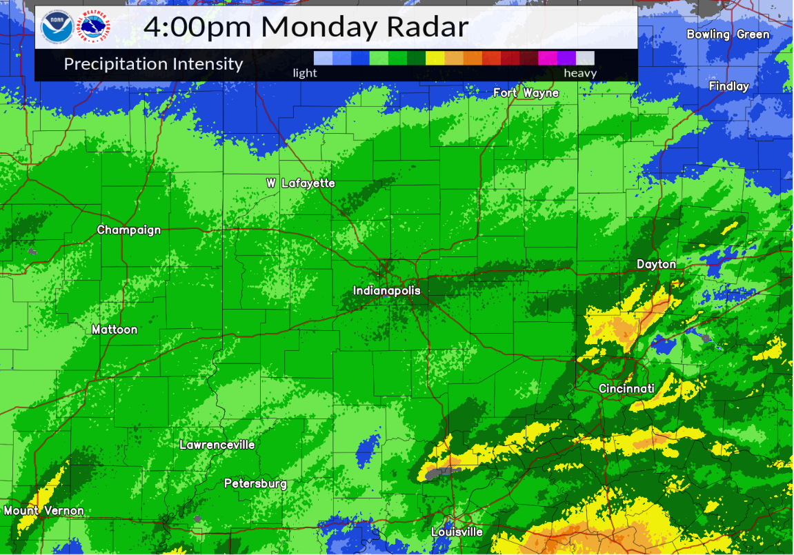
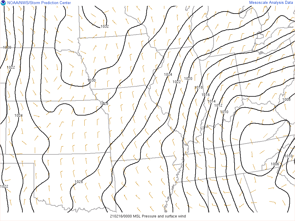
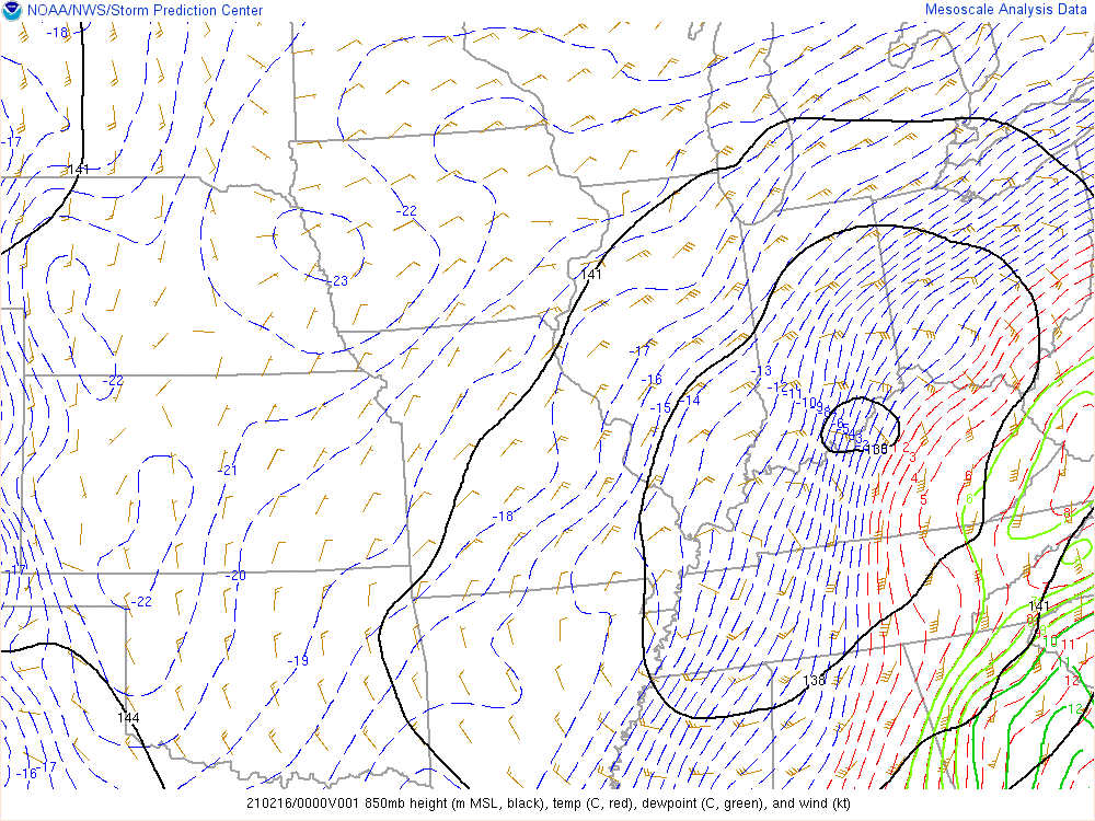
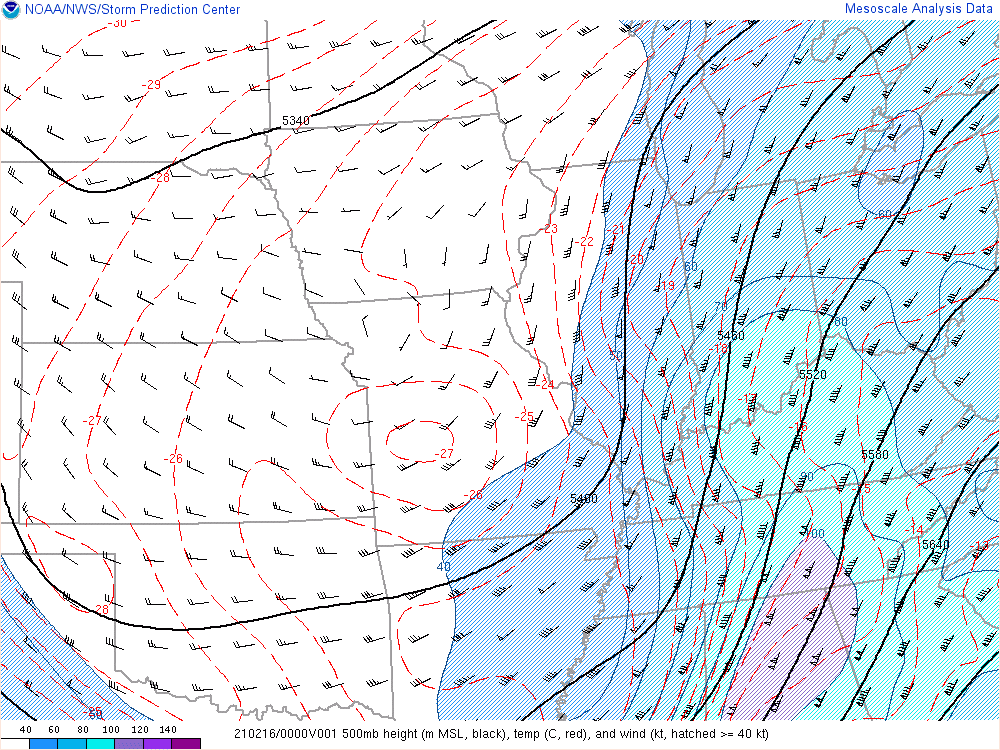
Environment/Radar
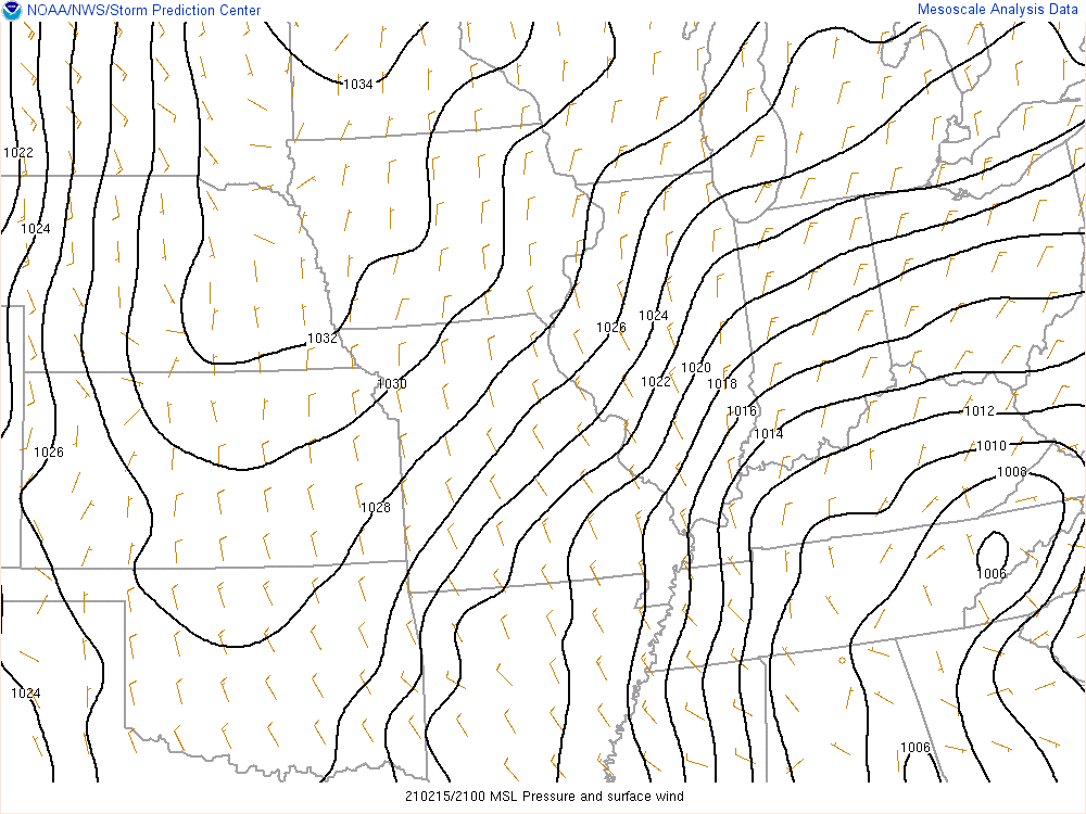
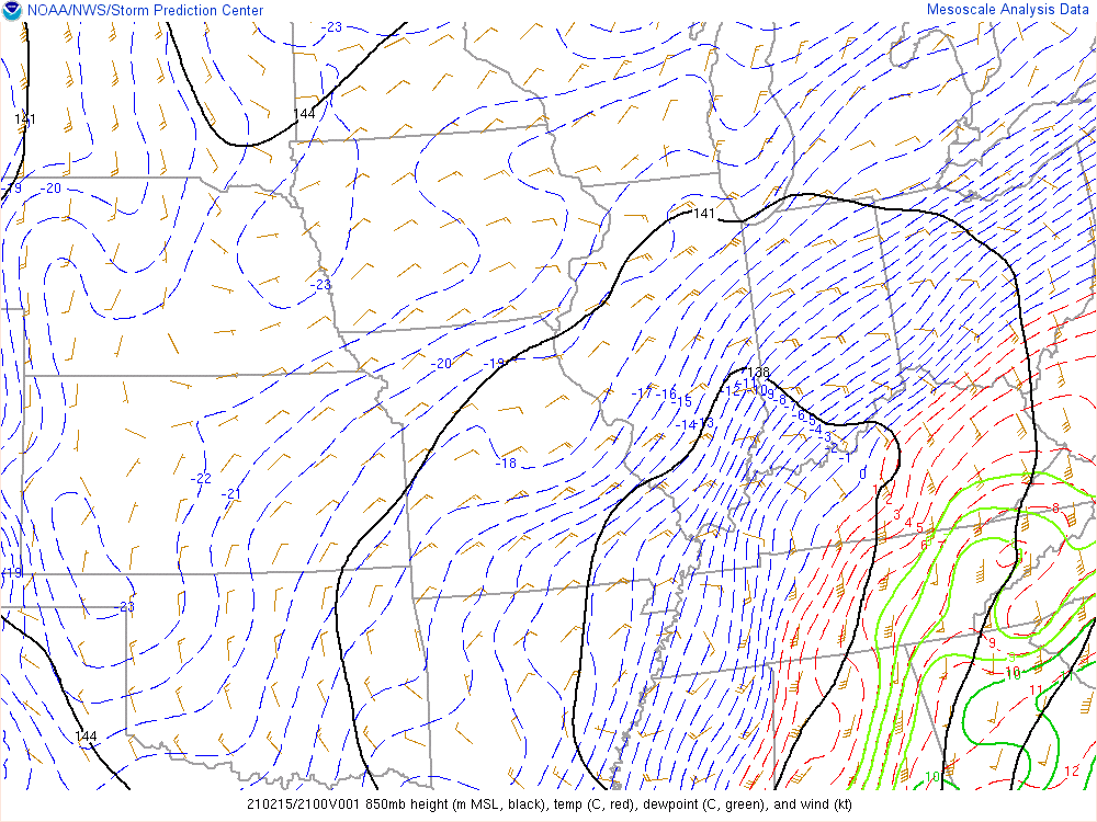
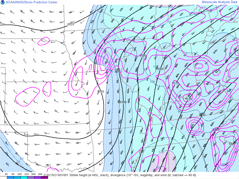
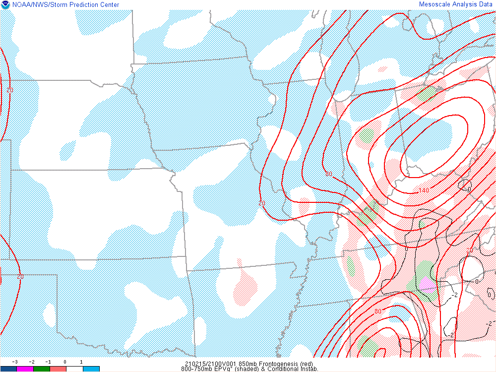
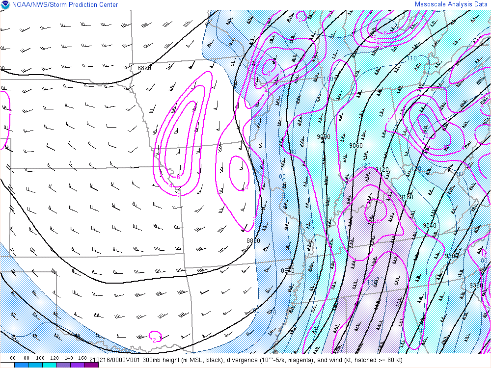
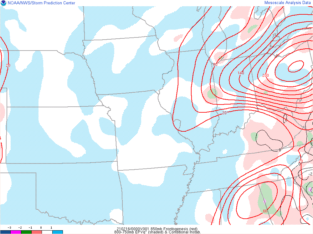
An upper level trough, upper level jet, low level jet, and an area of surface low pressure combined to bring the forcing and moisture necessary for heavy snow to central Indiana. Some instability aloft along with smaller scale forcing brought bands of heavier snow to some areas.
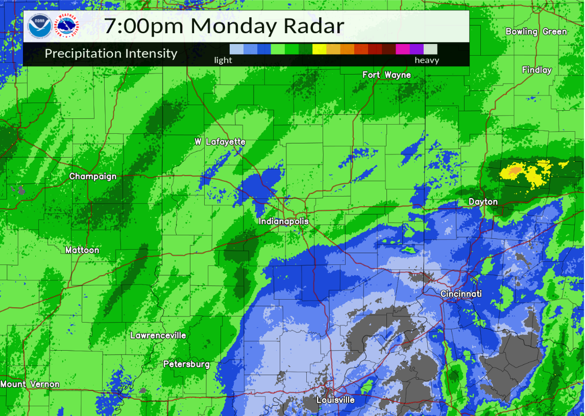
Selected environmental data from the event follows below. A radar loop from 4:00 PM EST to 10:00 PM EST is also available.
 |
 |
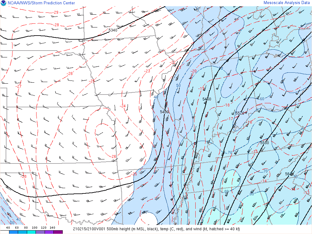 |
| Figure 1: Surface pressure and wind at 4 PM EST | Figure 2: 850mb plot at 4 PM EST | Figure 3: 500mb plot at 4 PM EST |
 |
 |
 |
| Figure 4: 300mb plot at 4 PM EST | Figure 5 - 850mb Frontogenesis and 850-700mb EPV at 4 PM EST | Figure 6: Radar at 4 PM EST |
 |
 |
 |
| Figure 7: Surface pressure and wind at 7 PM EST | Figure 8: 850mb plot at 7 PM EST | Figure 9: 500mb plot at 7 PM EST |
 |
 |
 |
| Figure 10: 300mb plot at 7 PM EST | Figure 11 - 850mb Frontogenesis and 850-700mb EPV at 7 PM EST | Figure 12: Radar at 7 PM EST |
Indianapolis Historical Perspective
Here is how this 2 day snow event ranked historically at Indianapolis:
I. 11 Greatest Indianapolis Area *February* 2-Day Snowstorms (Since 1872):
 1) 2/16-17/1910 16.1
 2) 2/24-25/1965 12.5
 3) 2/27-28/1984 12.2
 4) 2/21-22/1912 10.3
 5) 2/25-26/1979  8.3
T6) 2/15-16/2021  8.1**
T6) 2/13-14/2007  8.1
 8) 2/22-23/1914  7.9
T9) 2/04-05/2014  7.4
T9) 2/25-26/1993  7.4
T9) 2/25-26/1939  7.4

II. Chronicle Of The 20 Indianapolis Area 8+ Snowstorms (2-Day) Since 1970:
  2/15-16/2021  8.1**
  3/24-25/2018 10.2
  1/05-06/2014 11.4
  3/24-25/2013  9.1
  1/27-28/2009 12.3
  2/13-14/2007  8.1
 12/22-23/2004 10.1
  3/11-12/2000  8.1
  1/01-02/1999  9.6
  3/19-20/1996 11.8
 12/19-20/1995  8.0
 10/19-20/1989  9.1
  2/27-28/1984 12.2
  1/30-31/1982  8.1
  2/25-26/1979  8.3
  1/25-26/1978 15.2
 12/05-06/1977  9.6
  1/09-10/1977  8.0
 12/30-31/1973 11.4
 12/19-20/1973 12.6
 |
Media use of NWS Web News Stories is encouraged! Please acknowledge the NWS as the source of any news information accessed from this site. |
|

