
Catastrophic Super Typhoon Bavi's eyewall has reached Rota and is expected to bring dangerous winds, heavy rainfall and storm surge to Guam, Rota, Tinian and Saipan. A Typhoon Warning remains in effect. Heavy to excessive rainfall will continue to bring a flooding threat from coastal Mid-Atlantic to southern New England through Monday. Read More >
April 26-27, 2026 Rainfall
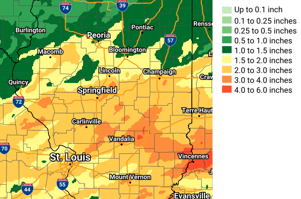
| CITY | COUNTY | RAINFALL |
| Lake Paradise | Coles | 5.25 |
| Birds 3W | Lawence | 4.50 |
| Watson | Effingham | 3.79 |
| Mattoon | Coles | 3.55 |
| Latham 2SW | Logan | 3.46 |
| Mattoon 2.1W | Coles | 3.26 |
| Lawrenceville | Lawrence | 3.19 |
| Springfield 4W | Sangamon | 3.13 |
| Robinson 3W | Crawford | 3.10 |
| Chatham | Sangamon | 3.05 |
| Springfield NE | Sangamon | 3.03 |
| Robinson | Crawford | 3.00 |
| Effingham | Effingham | 2.96 |
| Petersburg 8E | Menard | 2.94 |
| Tuscola | Douglas | 2.86 |
| Chatham 1.4ESE | Sangamon | 2.78 |
| Lake Springfield | Sangamon | 2.73 |
| Lincoln NWS | Logan | 2.71 |
| Bunnyville | Clay | 2.65 |
| Ogden | Champaign | 2.64 |
| Alma | Marion | 2.61 |
| Greenup SE | Cumberland | 2.57 |
| Charleston | Coles | 2.55 |
| West Peoria | Peoria | 2.35 |
| Bismarck 3W | Vermilion | 2.32 |
| Urbana 2ENE | Champaign | 2.30 |
| Bloomington 2E | McLean | 2.14 |
| Morton | Tazewell | 2.13 |
| Danville | Vermilion | 2.10 |
| Washington | Tazewell | 2.09 |
| Littleton 1NW | Schuyler | 2.08 |
| Lane | DeWitt | 1.95 |
| West Decatur | Macon | 1.90 |
| Lovington | Moultrie | 1.85 |
| Cisco 2NE | Piatt | 1.85 |
| Peoria 2.4NW | Peoria | 1.84 |
| Clinton | DeWitt | 1.81 |
| Brocton | Edgar | 1.78 |
| Astoria | Fulton | 1.59 |
| Rushville 3NE | Schuyler | 1.40 |
| Towanda 2N | McLean | 1.26 |
| Rushville 4E | Schuyler | 1.24 |
| Speer 3NE | Marshall | 0.95 |
| Wataga | Knox | 0.45 |

