Catastrophic Super Typhoon Bavi's eyewall has reached Rota and is expected to bring dangerous winds, heavy rainfall and storm surge to Guam, Rota, Tinian and Saipan. A Typhoon Warning remains in effect. Heavy to excessive rainfall will continue to bring a flooding threat from coastal Mid-Atlantic to southern New England through Monday. Read More >
April 3-4, 2011
As low pressure deepened over the Northern Plains, a warm front surged northward through central Illinois on Sunday, April 3rd. Due to a tightening pressure gradient within the warm sector of the storm system, strong southerly winds gusting over 50 mph developed during the afternoon. The ferocious winds caused minor damage around the area, including downing a few trees and damaging siding and gutters on several homes. Thanks to the southerly winds and sunshine, temperatures soared into the 80s. Record high temperatures were recorded in Springfield (86), Peoria (84), and Lincoln (83).
Despite a strong cold front approaching the Mississippi River Sunday afternoon, very warm air aloft initially "capped" the atmosphere...preventing convective development. As a vigorous upper-level disturbance across the Plains moved further eastward, temperatures aloft began to cool by early evening. This resulted in rapid thunderstorm development along the cold front from eastern Iowa southward into northern Missouri. The storms initially produced quite a bit of large hail after they initially developed, but gradually weakened as they pushed further eastward into central Illinois during the late evening and overnight hours.
Rainfall from the storms was highly variable, with most locations across central and southeast Illinois picking up between one quarter and one half an inch. The heaviest rain occurred along and just south of I-70, where training cells during the overnight hours produced over 1 inch.
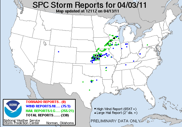
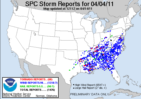
Thanks to everyone who provided weather data during this significant early spring event. Central Illinois really dodged a bullet this time around, since the Sunday evening storms weakened as they arrived. Additional thunderstorms re-developed along the advancing cold front on Monday, April 4th, producing widespread severe weather just off to the south and east...from the Ohio River Valley southward to the Gulf Coast. For your reference, I've attached two images from the Storm Prediction Center (SPC) below. The top image shows national severe weather reports received on April 3rd, and the bottom shows reports from April 4th.