National Weather Service United States Department of Commerce

Another Round of Heavy Rain and Mountain Snow in California; Snow in the Great Lakes and Northeast

Another round of heavy rainfall will renew concerns for additional flash flooding and landslides in southern California around burn scars and coastal mountain ranges. A low pressure system is bringing enhanced snowfall downwind from the lower Great Lakes into the Northeast mountain ranges. Above average temperatures will challenge or break daily record high temperatures across the southern Plains. Read More >

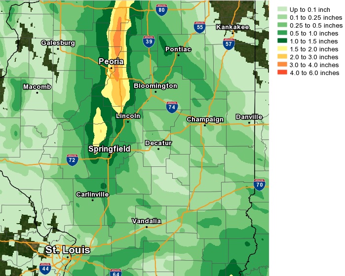
The remnants of Tropical Storm Alberto tracked northward along the Illinois/Indiana border this morning...with 11am observations showing the center of the low just east of Robinson.  Widespread moderate rain will continue to fall east of I-57 through mid-afternoon...with total rainfall amounts of 1.50 to 2.50 in that area.

 
Further northwest, a persistent band of moderate to heavy rain developed late last night into early this morning near the Illinois River.  This band dropped impressive rainfall amounts of 2 to 4 inches...with localized amounts as much as 5 inches from just northwest of Springfield northward to near Peoria and Henry.  
 
Flash flooding occurred across far eastern Peoria County, western Tazewell County, western Woodford County, and portions of Marshall County.  Several roads were closed due to high water, manhole covers were displaced in Pekin, and a mudslide occurred at Grosenback Road and Route 116 about 4 miles northeast of Peoria in far western Woodford County.
 
Here is a PRELIMINARY MAP of rainfall totals this morning: