National Weather Service United States Department of Commerce

Record Heat for the Intermountain West and Northern Plains; Heavy Rainfall and Severe Weather Threats

Record setting heat is expected over the next several days from the Intermountain West through the northern Plains. Furthermore, fire weather concerns increase with dry and breezy conditions. Meanwhile, heavy rainfall and severe thunderstorm threats for the Ohio/Tennessee Valleys, central Appalachians and Southeast today. The threat shifts to central Gulf Coast and across central Texas this week. Read More >

September Precipitation Highlights:
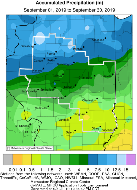
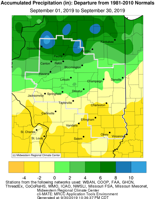
  • Rainfall ranged widely from well above normal in northern sections of central Illinois, to well below normal in east central and southeast Illinois.  Totals north of a Havana to Bloomington line were 2"-8" above normal, with the highest surpluses from Galesburg east through Lacon and Minonk.  Galesburg's monthly total of 11.39" was their second wettest September, while Peoria's 7.68" was 8th wettest.  In contrast, little rain fell southeast of a Shelbyville to Charleston line. Several sites south of I-70 saw less than 1" total for the month, which put these sites near their top 10 driest September, and 2"-3" below normal.


September Temperature Highlights:

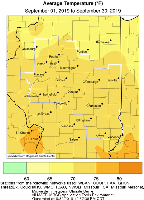
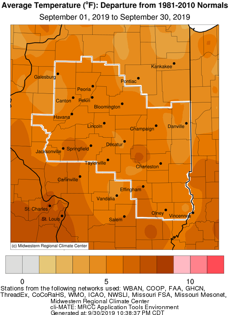
  • For the fifth year in a row, September temperatures were well above normal across central and southeast Illinois.  While the first week of the month was slightly below normal, the remainder of the month saw many days with mean temperatures 10 or more degrees above normal.  This resulted in monthly average temperatures in the lower 70s (more typical of August), and 5-6 degrees above normal.  This put several sites in their top 10 warmest September, including Springfield (5th), Peoria (5th), and Lincoln (8th).


September Climate Statistics:
 

City

Precipitation
 

Departure from Normal Average Temperature
 
Departure from Normal

Charleston

0.82" -2.42" 73.8 +6.0
Danville

4.52"

+1.59" 71.8 +5.1

Decatur

5.07" +1.93" 72.8 +5.0
Effingham 1.14" -1.85" 73.4 +6.2

Flora

0.85" -2.29" 74.2 +6.4

Galesburg

11.39" +7.92" 69.7 +5.0

Havana

5.30" +2.15" NA NA

Jacksonville

2.62" -1.08" 72.6 +5.3

Lincoln

4.46" +1.25" 71.2 +5.3

Normal

4.86"

+1.72" 70.2 +5.1

Olney

1.08" -1.99" 73.0 +5.2

Paris

2.15" -1.03" 70.8 +4.3

Peoria

7.68" +4.53" 72.3 +6.2
Springfield

7.06"

+4.16" 73.1 +6.3
Taylorville 3.25" -0.47" NA NA

Tuscola

3.40" +0.39" 71.4 +5.0

Urbana

3.36" +0.23" 72.1 +5.9


The following links are the monthly climate summaries for area cities. Only the summaries for Peoria, Springfield, and Lincoln are considered "official", meaning they are the station of record for their respective locations. The other summaries are "supplemental", meaning another location in the area is the official climate station for the city.

  • Peoria -- Peoria International Airport
  • Springfield -- Abraham Lincoln Capital Airport
  • Lincoln -- National Weather Service Office
  • Champaign -- University of Illinois-Willard Airport
  • Decatur -- Decatur Airport
  • Lawrenceville -- Lawrenceville-Vincennes International Airport
  • Mattoon -- Coles County Memorial Airport

Climate data for other cities is available at http://w2.weather.gov/climate/xmacis.php?wfo=ilx