A series of severe thunderstorms produced tornadoes, large hail, and damaging winds across central Illinois on May 3rd. Preliminary information regarding the event can be found on the "Reports" tab below. The meteorological summary and event photos will be updated over the next few days.

Details regarding the tornadoes that occurred across central Illinois on May 3rd can be seen below. A list of all severe weather reports (including hail and damaging wind) is included after the damage survey information.
115

NOUS43 KILX 270831

PNSILX

ILZ027>031-036>038-040>057-061>063-066>068-071>073-272031-


Public Information Statement

National Weather Service Lincoln IL

331 AM CDT Mon Jul 27 2026


...MAXIMUM HEAT INDEX REPORTS...


Location                     Heat Idx. Time/Date       Provider


...Illinois...


...Cass County...

Chandlerville                119 F     0215 PM 07/26   DAVIS


...Champaign County...

Philo                        101 F     0535 PM 07/26   DAVIS


...Christian County...

PANA                         122 F     0453 PM 07/26   CWOP


...Clark County...

Casey                        103 F     0600 PM 07/26   CWOP


...Clay County...

Flora Arpt                   120 F     0335 PM 07/26   AWOS


...Coles County...

Charleston                    99 F     0535 PM 07/26   ISWS


...Crawford County...

Oblong                       104 F     0715 PM 07/26   AWS

Robinson Arpt                102 F     0616 PM 07/26   AWOS


...Cumberland County...

Greenup                      101 F     0625 PM 07/26   DAVIS


...De Witt County...

Lane                         106 F     0500 PM 07/26   CWOP

Waynesville                  102 F     0600 PM 07/26   CWOP


...Douglas County...

Arcola                       107 F     0545 PM 07/26   CWOP

Arcola                       101 F     0425 PM 07/26   DAVIS

Arcola                       100 F     0455 PM 07/26   DAVIS


...Effingham County...

Beecher City                 107 F     0325 PM 07/26   DAVIS

Effingham Arpt               106 F     0315 PM 07/26   AWOS

Altamont                     100 F     0315 PM 07/26   DAVIS

Baraboo                       99 F     0715 PM 07/26   CWOP


...Fulton County...

Farmington                   126 F     0615 PM 07/26   DAVIS

London Mills                 126 F     0555 PM 07/26   DAVIS


...Jasper County...

Oblong                       102 F     0655 PM 07/26   DAVIS


...Knox County...

Delong                       119 F     0520 PM 07/26   CWOP

Galesburg                    116 F     0420 PM 07/26   CWOP

Galesburg Arpt               108 F     0315 PM 07/26   AWOS


...Lawrence County...

Mt Carmel Arpt               108 F     0535 PM 07/26   AWOS

Sumner                       105 F     0400 PM 07/26   DAVIS


...Logan County...

Mt. Pulaski                  114 F     0645 PM 07/26   CWOP

Logan County Arpt            112 F     0735 PM 07/26   AWOS


...Macon County...

Decatur Arpt                  99 F     0554 PM 07/26   ASOS


...Marshall County...

Henry                        113 F     0641 PM 07/26   CWOP

Toluca                       110 F     0225 PM 07/26   DAVIS

Lacon Arpt                   104 F     0455 PM 07/26   AWOS

Toluca                       102 F     0500 PM 07/26   DAVIS

Varna                        101 F     0620 PM 07/26   DAVIS


...Mason County...

Snicarte                     126 F     0645 PM 07/26   ISWS

2 SE Topeka                  125 F     0500 PM 07/26   MESOWEST

Mason City                   113 F     0615 PM 07/26   DAVIS


...McLean County...

Danvers                      106 F     0630 PM 07/26   DAVIS

Towanda                      106 F     0455 PM 07/26   CWOP

Bloomington Arpt             104 F     0456 PM 07/26   AWOS

Cooksville                   101 F     0155 PM 07/26   CWOP

Leroy                         99 F     0645 PM 07/26   DAVIS


...Morgan County...

Jacksonville Arpt            120 F     0455 PM 07/26   AWOS


...Moultrie County...

Sullivan                      99 F     0655 PM 07/26   DAVIS


...Peoria County...

Peoria                       111 F     0500 PM 07/26   DAVIS

Peoria Intl Arpt             110 F     0654 PM 07/26   ASOS

Peoria                       109 F     0559 PM 07/26   CWOP

Laura                        103 F     0555 PM 07/26   DAVIS


...Piatt County...

Monticello                   100 F     0605 PM 07/26   DAVIS


...Richland County...

Olney                        113 F     0405 PM 07/26   ISWS

Olney Noble AP               110 F     0350 PM 07/26   AWOS


...Sangamon County...

Springfield                  123 F     0555 PM 07/26   ISWS

Buffalo                      122 F     0555 PM 07/26   DAVIS

5.5 W Springfield            122 F     0315 PM 07/26   CWOP

Spfld Capital AP             119 F     0452 PM 07/26   ASOS


...Shelby County...

Moweaqua                     112 F     0705 PM 07/26   DAVIS


...Stark County...

Bradford                     106 F     0405 PM 07/26   DAVIS


...Tazewell County...

Washington                   120 F     0531 PM 07/26   CWOP

Green Valley                 117 F     0605 PM 07/26   DAVIS

East Peoria                  117 F     0631 PM 07/26   CWOP

Pekin                        116 F     0630 PM 07/26   CWOP

Morton                       115 F     0603 PM 07/26   CWOP

Washington                   112 F     0545 PM 07/26   CWOP

Groveland                    109 F     0525 PM 07/26   DAVIS

Goodfield                    103 F     0755 PM 07/26   CWOP

Armington                    102 F     0545 PM 07/26   DAVIS


...Vermilion County...

Danville                     104 F     0211 PM 07/26   CWOP

Rossville                     99 F     0220 PM 07/26   DAVIS

Hoopeston                     99 F     0335 PM 07/26   DAVIS


...Woodford County...

Eureka                       111 F     0555 PM 07/26   CWOP

Minonk                       110 F     0245 PM 07/26   DAVIS

1 NW Metamora                108 F     0536 PM 07/26   CWOP

2 N Panola                   105 F     0530 PM 07/26   AWS

GERMANTOWN HILLS             105 F     0645 PM 07/26   CWOP

Lowpoint                     105 F     0655 PM 07/26   DAVIS


Observations are collected from a variety of sources with varying

equipment and exposures. We thank all volunteer weather observers

for their dedication. Not all data listed are considered official.


$$


Geelhart
PRELIMINARY LOCAL STORM REPORT...SUMMARY...CORRECTED
NATIONAL WEATHER SERVICE LINCOLN IL
1122 PM CDT MON MAY 3 2021

..TIME...   ...EVENT...      ...CITY LOCATION...     ...LAT.LON...
..DATE...   ....MAG....      ..COUNTY LOCATION..ST.. ...SOURCE....
            ..REMARKS..

0455 PM     HAIL             3 SSE BLUFF SPRINGS     39.95N 90.33W
05/03/2021  E1.50 INCH       CASS               IL   COCORAHS


0504 PM     HAIL             VIRGINIA                39.95N 90.21W
05/03/2021  E1.50 INCH       CASS               IL   PUBLIC

            RELAYED BY BROADCAST MEDIA. DAMAGE TO CARS.

0505 PM     TORNADO          3 S VIRGINIA            39.91N 90.21W
05/03/2021                   CASS               IL   TRAINED SPOTTER

            ON GROUND IN OPEN FIELD. DIME SIZED HAIL.

0515 PM     HAIL             4 WSW NEWMANSVILLE      39.98N 90.08W
05/03/2021  E1.00 INCH       CASS               IL   FIRE DEPT/RESCUE

            RELAYED BY ASHLAND FIRE.

0527 PM     TORNADO          2 WNW PLEASANT PLAINS   39.88N 89.95W
05/03/2021                   SANGAMON           IL   STORM CHASER

            CORRECTION TO PREVIOUS REPORT OF TORNADO 3 N
            ASHLAND.

0532 PM     HAIL             3 S PETERSBURG          39.97N 89.85W
05/03/2021  E1.00 INCH       MENARD             IL   AMATEUR RADIO


0532 PM     TSTM WND DMG     3 S PETERSBURG          39.97N 89.85W
05/03/2021                   MENARD             IL   AMATEUR RADIO

            POWER POLES BLOWN DOWN INTO FIELD.

0610 PM     TORNADO          1 ESE DAWSON            39.85N 89.45W
05/03/2021                   SANGAMON           IL   PUBLIC

            BRIEF TOUCHDOWN NEAR I-72.

0612 PM     TSTM WND DMG     3 N DAWSON              39.90N 89.46W
05/03/2021                   SANGAMON           IL   TRAINED SPOTTER

            POWER POLES DOWNED.

0614 PM     TORNADO          1 NW MECHANICSBURG      39.82N 89.41W
05/03/2021  UF1              SANGAMON           IL   TRAINED SPOTTER

            CORRECTS PREVIOUS TORNADO REPORT FROM 1 NW
            MECHANICSBURG.

0718 PM     HAIL             1 S MACON               39.70N 89.00W
05/03/2021  E1.00 INCH       MACON              IL   PUBLIC


0728 PM     HAIL             5 WSW ROSAMOND          39.35N 89.25W
05/03/2021  E2.00 INCH       CHRISTIAN          IL   TRAINED SPOTTER


0824 PM     TSTM WND DMG     CHARLESTON              39.48N 88.18W
05/03/2021                   COLES              IL   EMERGENCY MNGR

            TREE BLOWN DOWN.


&&

$$
The following is a technical overview of the meteorological conditions that occurred during the May 3rd severe weather event across central Illinois.
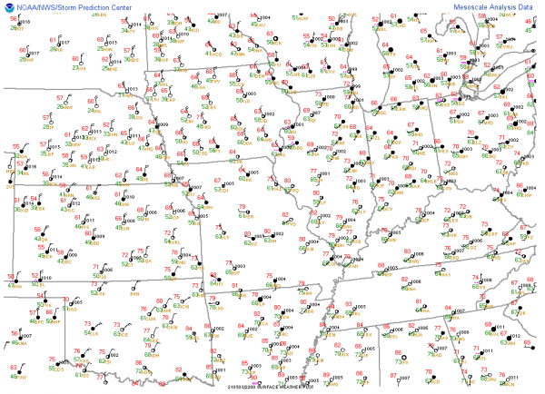
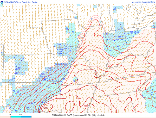
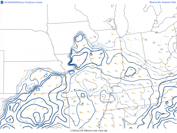
On Monday, May 3rd, thunderstorms developed along a cold front in north central Missouri and progressed into west central Illinois by mid-afternoon. Widespread cloud cover was in place across central Illinois through much of the morning and afternoon, but clouds diminished ahead of the cold front. In areas where the sun came out ahead of the front, temperatures climbed into the upper 70s. Dew point temperatures were in the mid-60s, resulting in a moderately unstable environment with around 1500 J/kg of mixed-layer convective available potential energy (MLCAPE). This instability combined with 35-45 knots of deep layer wind shear was supportive of severe weather. The angle between the shear vectors and the cold front was greater than 45 degrees, allowing for the development of supercells. The first image below shows the surface observations as of 22z/5pm, with the cold front pushing into west central Illinois. The second image shows the MLCAPE as of 22z/5pm. Note the lack of blue shading across central Illinois indicating the atmosphere is unstable and ready for thunderstorm development in the presence of a forcing mechanism (in this case, the forcing mechanism was the cold front). The second image shows the shear vectors at the same time.
The tornado threat was enhanced by a mesoscale convective vortex (MCV), an area of spin in the atmosphere that formed as a result of thunderstorms the previous day across Kansas/Nebraska, which tracked across north-central Missouri then northeastward across the Illinois River Valley. This MCV contributed to a surface wind shift, from southwesterly to southeasterly, ahead of the cold front. This localized wind shift increased the low-level wind shear, which increased the tornado potential.
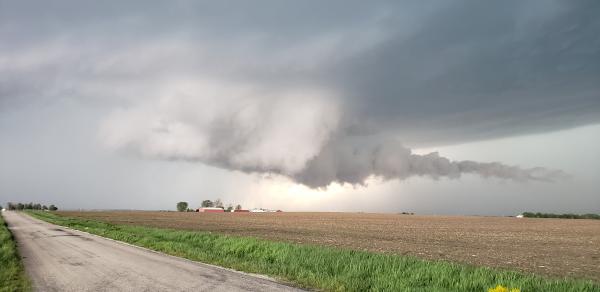
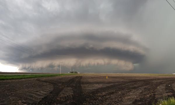
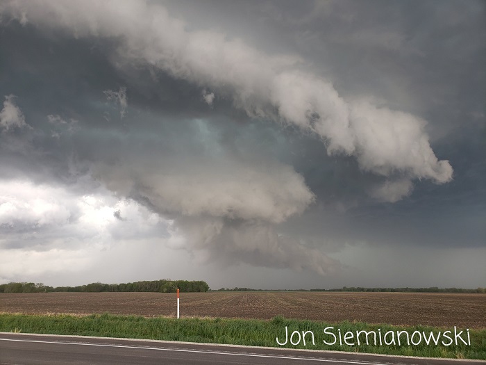
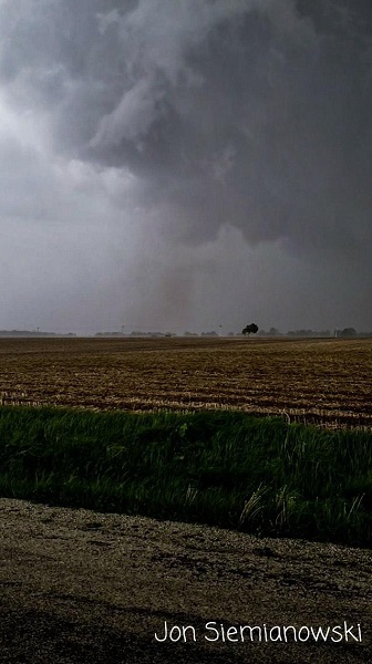
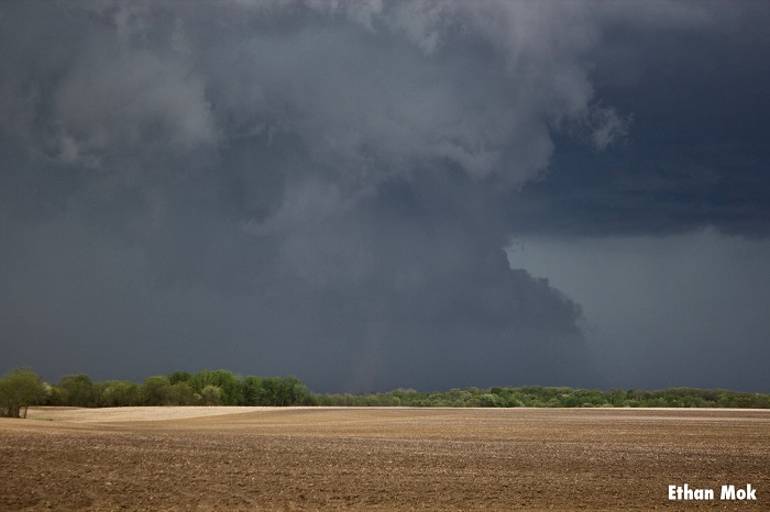
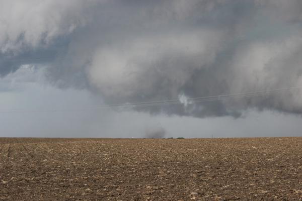
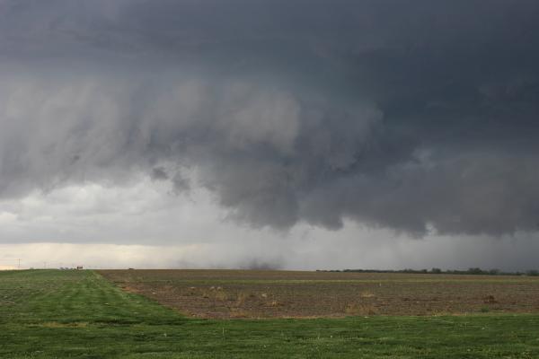
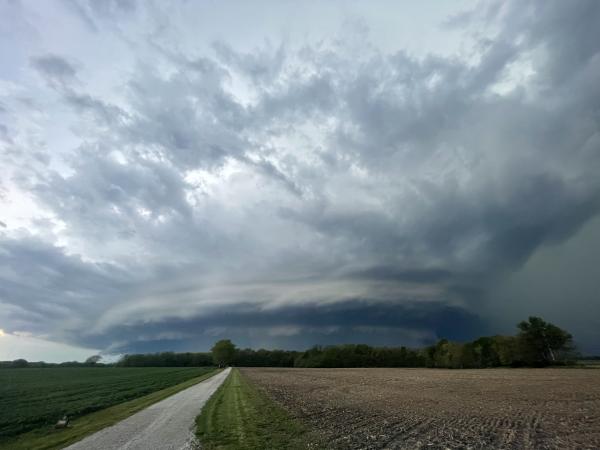
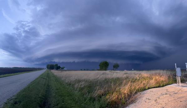
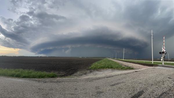
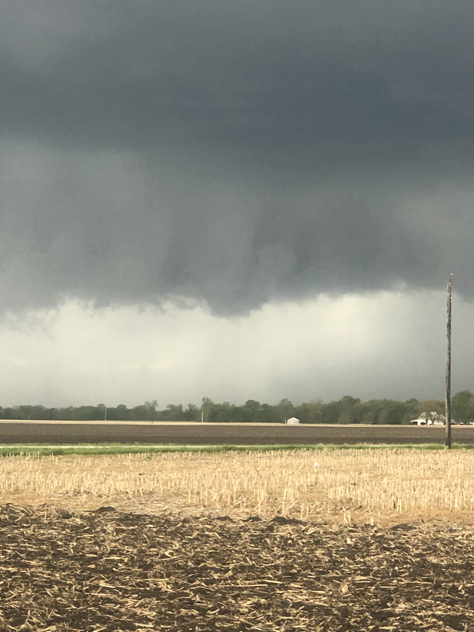
Several severe thunderstorms developed along the cold front and moved through central Illinois. The strongest storm tracked from Cass County east-southeastward towards Coles County. That storm produced at least four tornadoes and up to 2" hail (hen egg sized). (See the "Reports" tab for complete details regarding the location of tornadoes). All four tornadoes occurred primarily in open fields, and a tornado rating could not be assigned due to the lack of damage. The other severe thunderstorms produced large hail, but did not produce tornadoes. Overall, damage reports from the event were fairly limited. Power poles were blown down in Sangamon County, however, it is believed this damage was caused by straight line winds. Ping pong ball sized hail caused damage to vehicles in Virginia, IL. An observer five miles north of Buffalo, IL, reported that enough half-inch sized hail stones fell to cover the ground in hail.
Satellite Loop
Visible and IR satellite loop showing storm initiation in north-central Missouri during the late morning hours of May 3rd. As it moves eastward, a line of thunderstorms quickly develops and strengthens upon reaching the Illinois border with cold cloud tops (orange colors) indicating persistent updrafts. Additional cells develop southward into the favorable storm environment while the line progresses across the state. After sunset, storms begin to lose energy and weaken as they approach the Indiana border.
.gif)
Closer Look at Tornadic Storm
The loop below is a base reflectivity animation focusing on the supercell that went on to produce 5 tornados in central Illinois. This radar loop shows the early stages of this storm and spans 16 minutes from 4:41-4:57 PM local time. In this loop, red boxes indicate a severe thunderstorm warning and the purple box indicates a tornado warning.

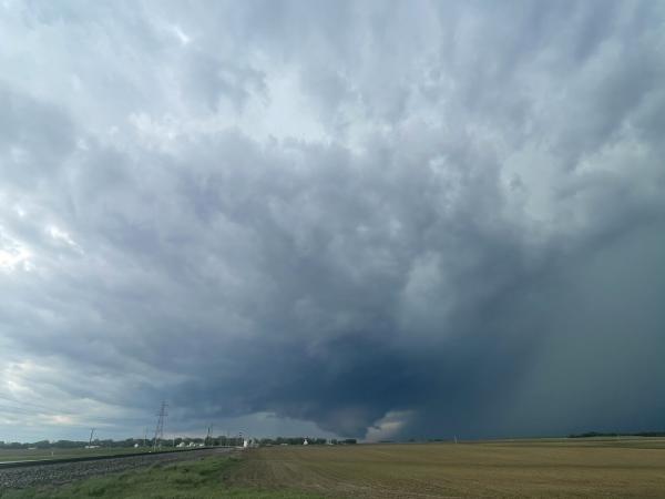
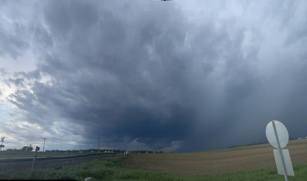
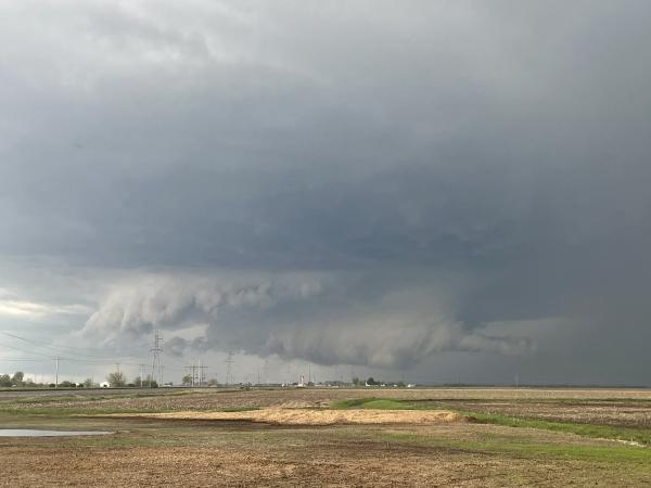
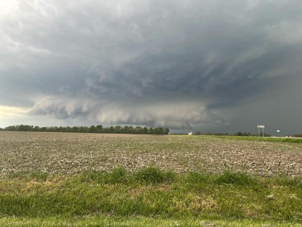
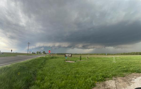
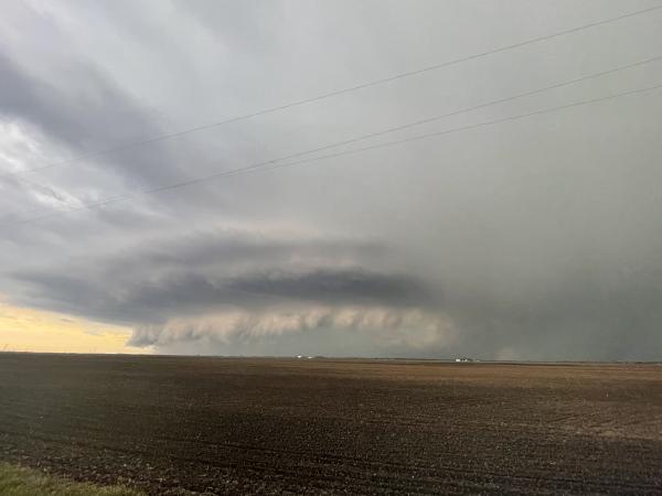
Photos of the thunderstorms across central Illinois. This section will be updated. If you have photos of the storms that you would like for us to include in the event summary, send us a tweet at @NWSLincolnIL with your picture, location, and permission to use your photo.
.jpg/Diego Garcia, 8S Virginia (2)__360x480.jpg)
.jpg/Diego Garcia, 8S Virginia (3)__360x480.jpg)