June Precipitation Highlights:
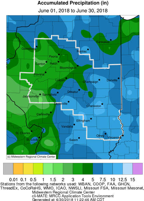
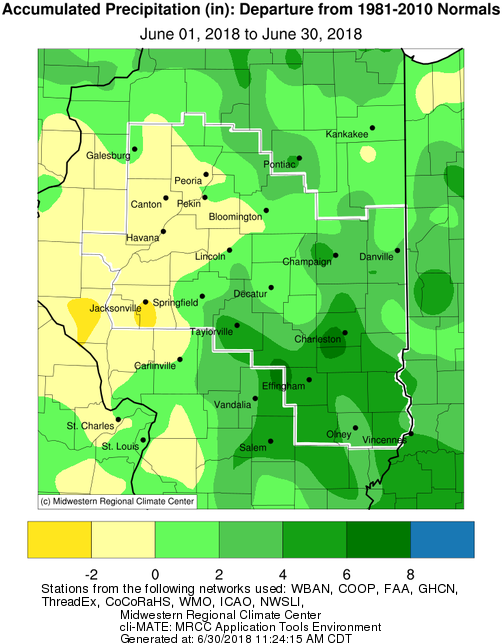
- Central Illinois was a transition zone between drier than normal conditions over the western part of the state, to much wetter than normal over eastern Illinois. Monthly totals of 1-2" below normal were common west of a Peoria to Springfield line. Farther east, multiple heavy rain events produced totals more than twice the monthly average over much of eastern Illinois. Charleston set their second wettest June (since 1896) with 11.15". Below is a summary of some of the more significant events this month.
- A persistent frontal boundary provided the focus for several rounds of thunderstorms from the early morning of Sunday, June 10th through the morning of Tuesday, June 12th. The most significant severe weather occurred Sunday afternoon when a line of thunderstorms spawned two EF-0 tornadoes on the southwest side of Champaign and created scattered wind damage from McLean County southeastward to Vermilion and Edgar counties. These storms dropped southeastward, creating heavy rain and flash flooding along and south of I-70 Sunday evening. Additional thunderstorms developed along the boundary later Sunday night into Monday morning, then again Monday afternoon and night. Copious amounts of rain fell during this time, with areas from Taylorville southeastward to Mattoon and Robinson picking up 6 to 8 inches.
- Scattered thunderstorms developed across central Illinois during the afternoon of June 19th. Meanwhile further west, a line of thunderstorms tracked across southern Iowa and northern Missouri into west-central Illinois during the late afternoon. These cells produced gusty winds of 40-50 mph that downed a few tree branches. As this line settled southward during the evening, it slowed its forward progress and dumped locally heavy rainfall of 3-4 inches across portions of Fayette and Effingham counties. A weather observer in Watson (Effingham Co.) measured 3.22".
 |
 |
| June Precipitation |
June Precipitation Departure from Normal |
June Temperature Highlights:
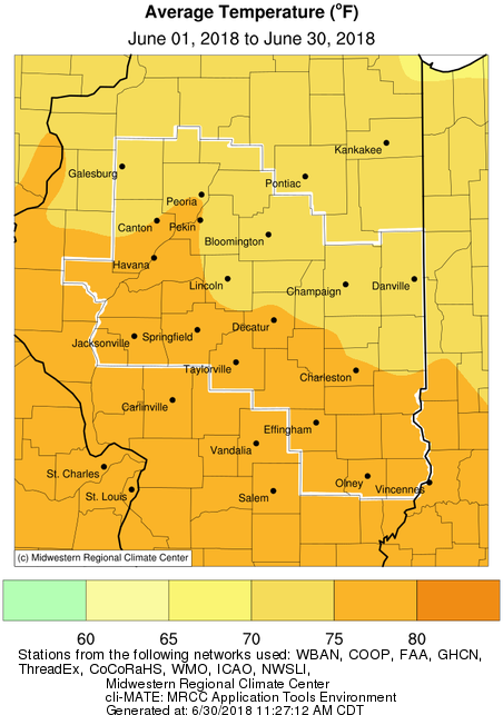
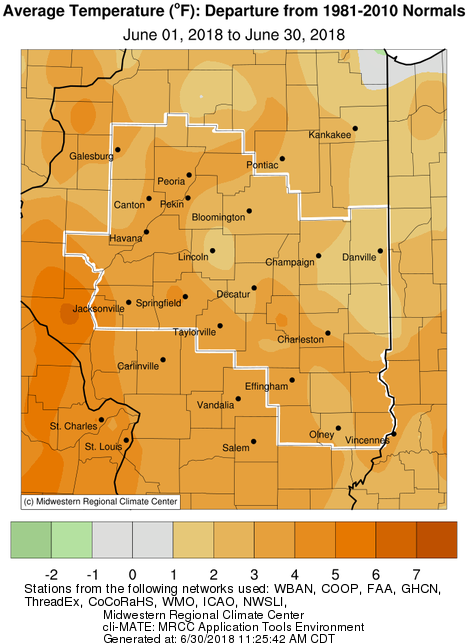
- June was another month of well above normal temperatures across the region. Monthly averages of 2-5 degrees above normal were common over central Illinois. Several locations were just outside their Top 10 warmest June. Strong heatwaves affected the area on June 15-19, and again June 29-30. High temperatures in the low to mid 90s combined with high humidity levels to produce peak afternoon heat indices of 105-115 degrees during these stretches.
 |
 |
| June Mean Temperature |
June Temperature Departure from Normal |
June Climate Data:
|
Site
|
Precipitation
|
Departure from Normal |
Average Temperature
|
Departure from Normal |
Notes |
|
Charleston
|
11.15" |
+6.80" |
NA |
NA |
2nd wettest June since 1896 |
| Danville |
5.47"
|
+0.92" |
74.3 |
+2.2 |
|
| Decatur |
5.68"
|
+1.18" |
75.9 |
+2.6 |
|
| Effingham |
8.31" |
+3.85" |
76.9 |
+4.0 |
|
|
Flora
|
9.82" |
+5.64" |
78.0 |
+3.9 |
|
| Galesburg |
6.18"
|
+1.88" |
74.6 |
+3.5 |
|
|
Havana
|
4.26" |
+0.03" |
NA |
NA |
|
|
Jacksonville
|
2.49" |
-1.99" |
76.4 |
+3.4 |
|
| Lincoln |
4.12" |
-0.20" |
73.6 |
+1.5 |
|
|
Normal
|
6.40"
|
+2.49" |
73.8 |
+2.4 |
|
|
Olney
|
6.14" |
+1.95" |
76.1 |
+2.7 |
|
|
Paris
|
5.01" |
+0.66" |
73.7 |
+1.2 |
|
| Peoria |
3.41"
|
-0.12" |
75.7 |
+3.9 |
|
| Springfield |
4.29"
|
-0.17" |
77.0 |
+4.5 |
|
|
Tuscola
|
8.37" |
+3.93" |
74.9 |
+2.1 |
|
| Urbana |
8.26"
|
+3.92" |
NA |
NA |
|
The following links are the monthly and seasonal climate summaries for area cities. Only the summaries for Peoria, Springfield, and Lincoln are considered "official", meaning they are the station of record for their respective locations. The other summaries are "supplemental", meaning another location in the area is the official climate station for the city.
Climate data for other cities is available at http://w2.weather.gov/climate/xmacis.php?wfo=ilx


