Overview
|
Strong to severe storms rolled through the Lincoln NWS forecast area during the evening of Friday, June 18 and continued through the early morning hours of Saturday, June 19. Several reports of wind damage were reported from just south of Galesburg eastward toward Bloomington, including a few estimated wind gusts of 80-90 mph in southern Knox/northern Fulton counties. A survey team confirmed that an EF-1 tornado occurred in southern Knox county shortly before midnight. Additional reports of damage were reported near Springfield, Decatur, and south of Champaign later on in the night. |
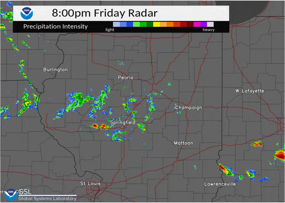 Radar imagery June 18-19, 2021 |
Tornadoes:
|
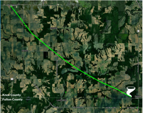
Tornado - Southern Knox County
|
||||||||||||||||
The Enhanced Fujita (EF) Scale classifies tornadoes into the following categories:
| EF0 Weak 65-85 mph |
EF1 Moderate 86-110 mph |
EF2 Significant 111-135 mph |
EF3 Severe 136-165 mph |
EF4 Extreme 166-200 mph |
EF5 Catastrophic 200+ mph |
 |
|||||
Photos & Video
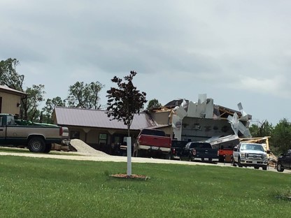
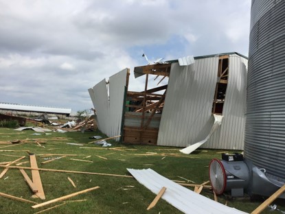
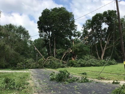
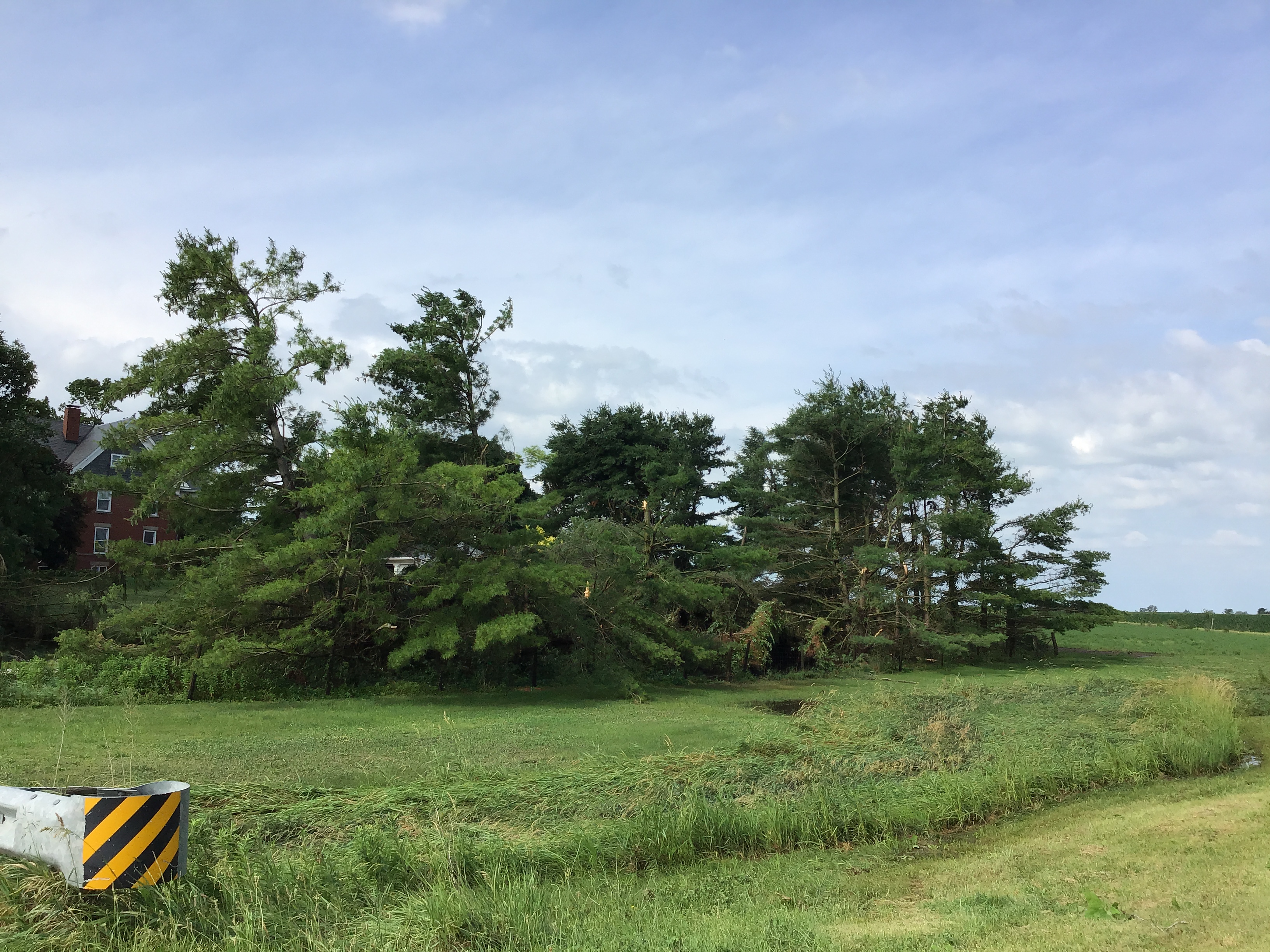
Knox County - Tornado Damage
 |
 |
.jpg) |
|
East of Abingdon, Knox Road 700 |
Southeast of Abingdon, Knox Highway 8 |
Southeast of Abingdon, Knox Road 800 |
 |
.jpg) |
 |
|
North of London Mills, Knox Road 850 |
North of London Mills, Knox Road 850 |
London Mills, Know Highway 29 |
 |
|
East of London Mills, Illinois Route 97 |
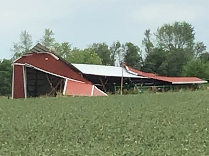
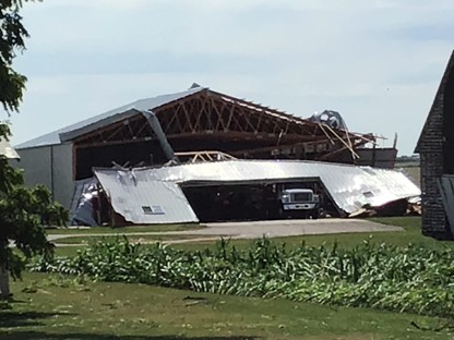
Fulton County - Straight Line Wind Damage
 |
.jpg) |
.jpg) |
|
Northwest of Canton, E Cyprus Rd |
Northwest of Canton, Fulton Highway 21 |
Northwest of Canton, Fulton Highway 21 |
Storm Reports
PRELIMINARY LOCAL STORM REPORT...SUMMARY
NATIONAL WEATHER SERVICE LINCOLN IL
241 AM CDT SUN JUN 20 2021

..TIME...   ...EVENT...      ...CITY LOCATION...     ...LAT.LON...
..DATE...   ....MAG....      ..COUNTY LOCATION..ST.. ...SOURCE....
            ..REMARKS..

0802 PM     TSTM WND GST     JACKSONVILLE AIRPORT    39.77N 90.24W
06/18/2021  M51 MPH          MORGAN             IL   AWOS


0846 PM     TSTM WND GST     3 SW CHATHAM            39.65N 89.74W
06/18/2021  M52 MPH          SANGAMON           IL   TRAINED SPOTTER


0854 PM     HAIL             1 S GRANDVIEW           39.80N 89.62W
06/18/2021  E0.75 INCH       SANGAMON           IL   BROADCAST MEDIA

            ESTIMATED PEA TO PENNY SIZE HAIL.

1129 PM     TSTM WND GST     GALESBURG AIRPORT       40.94N 90.43W
06/18/2021  M58 MPH          KNOX               IL   AWOS


1140 PM     TSTM WND DMG     ABINGDON                40.80N 90.40W
06/18/2021                   KNOX               IL   TRAINED SPOTTER

            DELAYED REPORT. TREE AND POWERLINE DAMAGE.
            POWER OUTAGES IN TOWN. TIME ESTIMATED FROM
            RADAR.

1140 PM     HAIL             3 SE GROVELAND          40.57N 89.50W
06/18/2021  M0.88 INCH       TAZEWELL           IL   TRAINED SPOTTER

            REPORT RELAYED BY EMERGENCY MANAGER.

1140 PM     TSTM WND DMG     2 SE SAINT AUGUSTINE    40.70N 90.38W
06/18/2021                   FULTON             IL   TRAINED SPOTTER

            REPORT OF SEVERAL TREES SNAPPED, A HEAVILY
            DAMAGED BARN, AND ESTIMATED WIND SPEEDS OF
            80-90 MPH WINDS.

1150 PM     TORNADO          3 SW DELONG             40.79N 90.34W
06/18/2021                   KNOX               IL   NWS STORM SURVEY

            THIS TORNADO MAINLY DAMAGED TREES, CROPS,
            POWER POLES/LINES. THERE WAS ALSO
            SIGNIFICANT DAMAGE TO FARM OUTBUILDINGS AND
            DEBRIS WAS THROWN HALF A MILE. THE TORNADO
            ENDED 3 WNW OF MIDDLE GROVE AT 1205 AM. PATH
            LENGTH WAS 10.4 MILES. WIDTH WAS 250 YARDS.
            PEAK WIND WAS 110 MPH.

1150 PM     TSTM WND DMG     4 N ABINGDON            40.87N 90.40W
06/18/2021                   KNOX               IL   TRAINED SPOTTER

            DOWNED POWER LINES AND TREES SNAPPED ON
            ROUTE 41.

1150 PM     TSTM WND DMG     3 E LONDON MILLS        40.71N 90.21W
06/18/2021                   FULTON             IL   TRAINED SPOTTER

            REPORT OF NUMEROUS TREES SNAPPED, GRAIN
            ELEVATORS SEVERELY DAMAGED, AND POWERLINES
            BLOWN DOWN. ESTIMATED 80 MPH WINDS BASED ON
            DAMAGE.

1152 PM     TSTM WND DMG     4 E LONDON MILLS        40.71N 90.19W
06/18/2021                   FULTON             IL   TRAINED SPOTTER

            REPORT OF FARM EQUIPMENT BUILDINGS DAMAGED
            AND POWERLINES BLOWN INTO FIELD.

1200 AM     TSTM WND GST     3 E SAINT AUGUSTINE     40.73N 90.35W
06/19/2021  E90 MPH          KNOX               IL   PUBLIC


1200 AM     TSTM WND DMG     FAIRVIEW                40.63N 90.16W
06/19/2021                   FULTON             IL   EMERGENCY MNGR

            TREES DOWN. TIME ESTIMATED BY RADAR.

1206 AM     TSTM WND DMG     4 SW NORRIS             40.59N 90.09W
06/19/2021                   FULTON             IL   PUBLIC

            POWER LINE AND POWER POLES BROKEN OFF.

1210 AM     HAIL             CANTON                  40.56N 90.04W
06/19/2021  E0.88 INCH       FULTON             IL   PUBLIC

            PEA TO PENNY SIZE HAIL. REPORT RELAYED BY
            BROADCAST MEDIA. TIME ESTIMATED BY RADAR.

1210 AM     TSTM WND DMG     CANTON                  40.56N 90.04W
06/19/2021                   FULTON             IL   EMERGENCY MNGR

            TREES AND POWER LINES DOWN ALONG ROUTE 9
            WEST OF CANTON. TIME ESTIMATED BY RADAR.

1210 AM     TSTM WND DMG     CANTON                  40.56N 90.04W
06/19/2021                   FULTON             IL   PUBLIC

            LOTS OF TREES DOWN ON NORTH SIDE OF CANTON.
            REPORT RELAYED BY BROADCAST MEDIA. TIME
            ESTIMATED BY RADAR.

1210 AM     TSTM WND DMG     1 W CANTON              40.56N 90.06W
06/19/2021                   FULTON             IL   PUBLIC

            ROOF AND SIDING DAMAGE. TIME ESTIMATED BY
            RADAR.

1245 AM     TSTM WND GST     SOUTH PEKIN             40.49N 89.66W
06/19/2021  E60 MPH          TAZEWELL           IL   TRAINED SPOTTER

            REPORT RELAYED BY EMERGENCY MANAGER.

1250 AM     TSTM WND DMG     1 S SOUTH PEKIN         40.48N 89.66W
06/19/2021                   TAZEWELL           IL   EMERGENCY MNGR

            TREES DOWN.

1254 AM     TSTM WND GST     1 NNE PEORIA INTL AIRPO 40.67N 89.68W
06/19/2021  M51 MPH          PEORIA             IL   ASOS

            .

1254 AM     TSTM WND GST     1 NNE PEORIA INTL AIRPO 40.67N 89.68W
06/19/2021  M51 MPH          PEORIA             IL   ASOS


1258 AM     TSTM WND DMG     PEKIN                   40.57N 89.64W
06/19/2021                   TAZEWELL           IL   BROADCAST MEDIA

            REPORT OF A LARGE TREE DOWN ON CARS.

1258 AM     TSTM WND GST     TREMONT                 40.53N 89.49W
06/19/2021  M77 MPH          TAZEWELL           IL   EMERGENCY MNGR

            CORRECTS PREVIOUS TSTM WND GST REPORT FROM
            TREMONT. MEASURED AT EOC.

0100 AM     TSTM WND DMG     1 N PEKIN               40.58N 89.64W
06/19/2021                   TAZEWELL           IL   PUBLIC


0102 AM     TSTM WND GST     3 SSW MORTON            40.57N 89.48W
06/19/2021  M60 MPH          TAZEWELL           IL   EMERGENCY MNGR


0109 AM     TSTM WND GST     MACKINAW                40.53N 89.36W
06/19/2021  M58 MPH          TAZEWELL           IL   EMERGENCY MNGR


0111 AM     TSTM WND DMG     2 SE PEKIN              40.54N 89.61W
06/19/2021                   TAZEWELL           IL   PUBLIC

            REPORT FROM MPING: 1-INCH TREE LIMBS BROKEN;
            SHINGLES BLOWN OFF.

0200 AM     TSTM WND DMG     3 N SHIRLEY             40.44N 89.07W
06/19/2021                   MCLEAN             IL   PUBLIC


0315 AM     TSTM WND DMG     1 W DECATUR             39.84N 88.98W
06/19/2021                   MACON              IL   PUBLIC


0316 AM     TSTM WND DMG     RIDGE FARM              39.90N 87.65W
06/19/2021                   VERMILION          IL   EMERGENCY MNGR

            TREE REPORTED DOWN IN ROAD AND ON POWER
            LINES.

0331 AM     HAIL             1 SE MOUNT ZION         39.77N 88.86W
06/19/2021  U0.75 INCH       MACON              IL   PUBLIC

            REPORT FROM MPING: DIME (0.75 IN.).

0338 AM     TSTM WND DMG     SIDNEY                  40.02N 88.07W
06/19/2021                   CHAMPAIGN          IL   BROADCAST MEDIA

            LARGE TREE DOWN IN TOWN.

0345 AM     TSTM WND DMG     NEWMAN                  39.80N 87.98W
06/19/2021                   DOUGLAS            IL   EMERGENCY MNGR

            POWER POLES SNAPPED AND LINES DOWN. POWER
            COMPANY ON SCENE FOR REPAIRS.

0345 AM     TSTM WND DMG     NEWMAN                  39.80N 87.99W
06/19/2021                   DOUGLAS            IL   EMERGENCY MNGR

            TREE THROUGH A ROOF IN THE 600 BLOCK OF W
            GREEN ST.

0352 AM     TSTM WND DMG     NEWMAN                  39.80N 87.98W
06/19/2021                   DOUGLAS            IL   EMERGENCY MNGR

            POWER POLES SNAPPED AND LINES DOWN AT GABE
            STREET AND N HOWARD STREET. POWER COMPANY ON
            SITE FOR REPAIRS.

0352 AM     TSTM WND DMG     NEWMAN                  39.80N 87.98W
06/19/2021                   DOUGLAS            IL   EMERGENCY MNGR

            TREE THROUGH A ROOF IN THE 600 BLOCK OF W
            GREEN STREET.

0410 AM     TSTM WND DMG     CHRISMAN                39.80N 87.68W
06/19/2021                   EDGAR              IL   BROADCAST MEDIA

            MULTIPLE LARGE TREE LIMBS DOWNED ACROSS
            TOWN. DIAMETER OF 12 INCHES OR GREATER.
            DOWNED LIMBS CAUSED STRUCTURAL DAMAGE TO
            HOMES.

0548 AM     TSTM WND DMG     2 SW BRIDGEPORT         38.69N 87.78W
06/19/2021                   LAWRENCE           IL   PUBLIC

            REPORT FROM MPING: TREES UPROOTED OR
            SNAPPED; ROOF BLOWN OFF.

0653 AM     TSTM WND DMG     2 N GRANDVIEW           39.84N 89.62W
06/19/2021                   SANGAMON           IL   TRAINED SPOTTER

            6 INCH HEALTHY TREE LIMB SNAPPED.

0656 AM     TSTM WND GST     CAPITAL AIRPORT         39.84N 89.68W
06/19/2021  M70 MPH          SANGAMON           IL   ASOS


1035 AM     TSTM WND GST     2 W WAVERLY             39.60N 89.99W
06/19/2021  E60 MPH          MORGAN             IL   EMERGENCY MNGR

            AGRICULTURAL FIELDS SEVERELY DAMAGED BY WIND
            AND SMALL HAIL.
 |
Media use of NWS Web News Stories is encouraged! Please acknowledge the NWS as the source of any news information accessed from this site. |
|