Overview
|
After strong thunderstorms in the morning of May 26th, the remnant outflow boundary left behind helped fire more severe weather during the afternoon and evening hours. This was focused on areas near and south of I-70 in Illinois, producing several tornadoes, straight-line wind damage, and large hail. This page concentrates on the weather that occurred over Clay, Richland and Lawrence Counties. Information on neighboring areas will be posted at the following web sites:
|
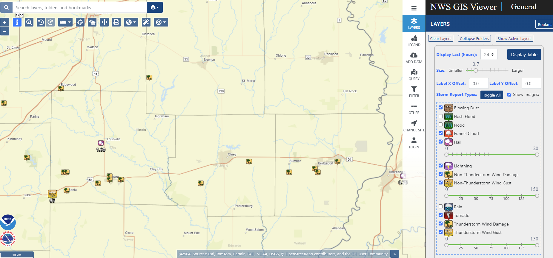
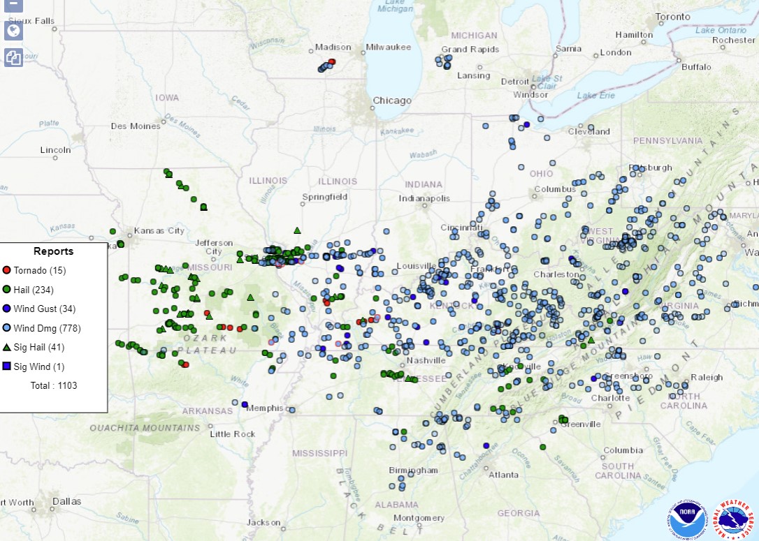 Severe weather reports from May 26 across the Midwest |
Tornadoes
|
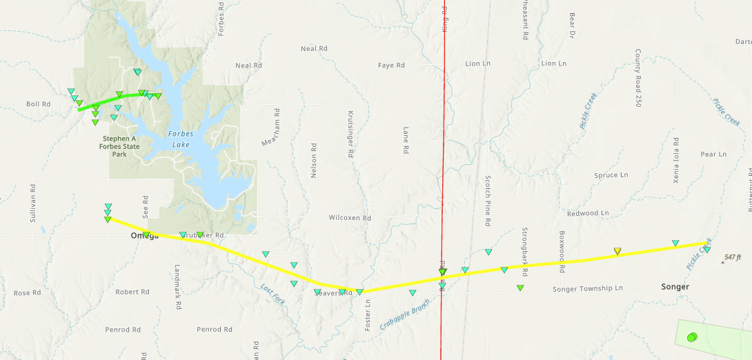
Xenia Tornado
|
||||||||||||||||
|
||||||||||||||||
|
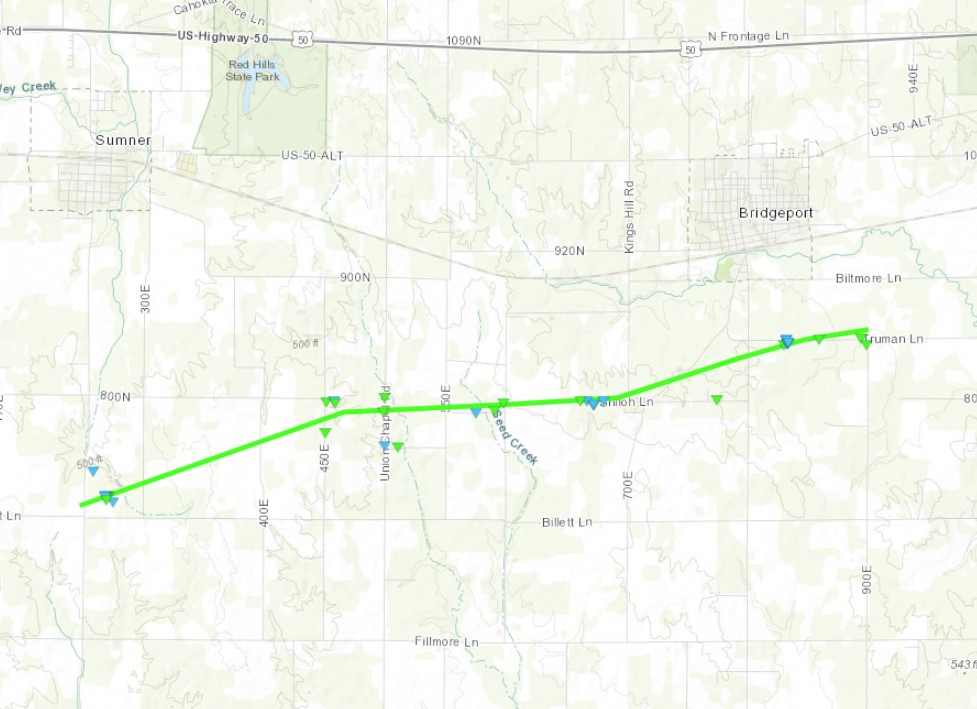
Sumner-Bridgeport Tornado
|
||||||||||||||||
|
||||||||||||||||
|
Tornado - LOCATION
Track Map 
Downloadable KMZ File |
||||||||||||||||
|
||||||||||||||||
|
Tornado - LOCATION
Track Map
Downloadable KMZ File |
||||||||||||||||
|
||||||||||||||||
The Enhanced Fujita (EF) Scale classifies tornadoes into the following categories:
| EF0 Weak 65-85 mph |
EF1 Moderate 86-110 mph |
EF2 Significant 111-135 mph |
EF3 Severe 136-165 mph |
EF4 Extreme 166-200 mph |
EF5 Catastrophic 200+ mph |
 |
|||||
Photos & Video
Header
| Caption (source) |
Caption (source) |
Caption (source) |
Caption (source) |
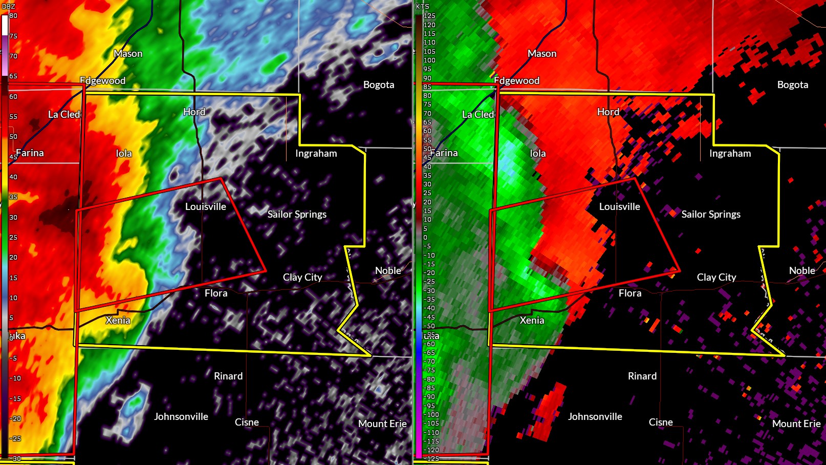
Radar
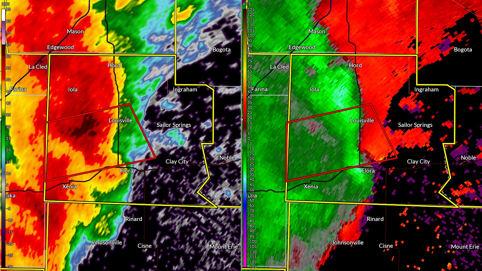
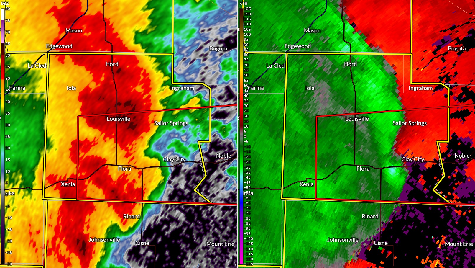
Images from the Evansville, IN radar (KVWX)
 |
 |
 |
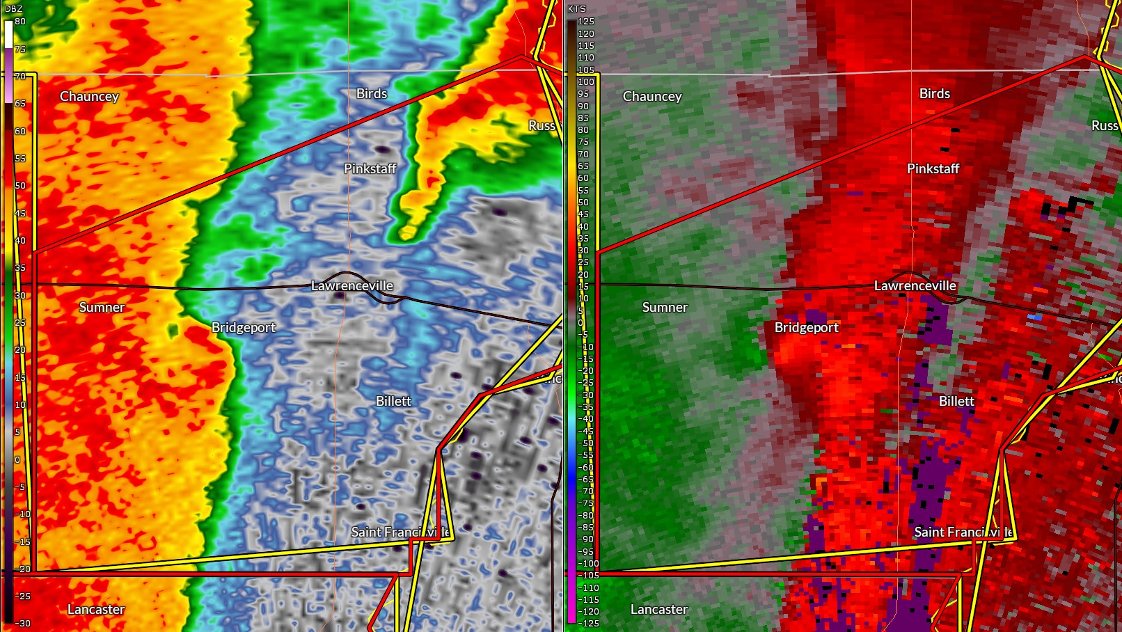 |
| 7:39 pm CDT | 7:45 pm CDT | 7:52 pm CDT | 8:34 pm CDT |
In these images, the left side of the panel shows the reflectivity image, and the right side is the storm-relative velocity image). At 7:39 pm, a small "nub" and notch is seen on the reflectivity north of Xenia, which corresponds to an area of rotation. With the storms moving quicky, this feature reached the Flora area by 7:45 pm and was near Clay City by 7:52 pm. While not as prominent as it went across Richland County, by the time the storms reached western Lawrence County (8:34 pm), it was starting to appear again near Bridgeport.
Storm Reports
..TIME...   ...EVENT...      ...CITY LOCATION...     ...LAT.LON...
..DATE...   ....MAG....      ..COUNTY LOCATION..ST.. ...SOURCE....
            ..REMARKS..

0738 PM     Tstm Wnd Dmg     Xenia                   38.64N 88.64W
05/26/2024                   Clay               IL   Emergency Mngr

            Numerous trees and power lines were blown
            down.

0738 PM     Tstm Wnd Dmg     4 N Xenia               38.69N 88.64W
05/26/2024                   Clay               IL   Fire Dept/Rescue

            Hog barn leveled and several power poles
            leaning or broken. Debris from the barn was
            entangled in the power lines.

0738 PM     Tstm Wnd Gst     3 W Xenia               38.63N 88.69W
05/26/2024  E65 MPH          Clay               IL   Emergency Mngr


0740 PM     Tstm Wnd Dmg     Flora                   38.67N 88.49W
05/26/2024                   Clay               IL   Emergency Mngr

            Numerous trees were blown down, including
            one that fell onto a camper at Charley Brown
            Park. No injuries reported.

0740 PM     Tstm Wnd Dmg     1 N Flora               38.68N 88.49W
05/26/2024                   Clay               IL   Broadcast Media

            Several trees were blown down.

0742 PM     Tstm Wnd Dmg     Flora                   38.67N 88.49W
05/26/2024                   Clay               IL   Public

            A tree was snapped and power lines were
            knocked down.

0742 PM     Tstm Wnd Dmg     3 W Flora               38.66N 88.53W
05/26/2024                   Clay               IL   Emergency Mngr

            Tree limbs down onto camper at Charlie Brown
            Park.

0743 PM     Tstm Wnd Dmg     Flora                   38.67N 88.49W
05/26/2024                   Clay               IL   Emergency Mngr

            A large tree was blown onto a house,
            trapping people inside. No injuries were
            reported.

0745 PM     Tstm Wnd Dmg     Flora Municipal Airport 38.67N 88.45W
05/26/2024                   Clay               IL   Broadcast Media

            Several trees were blown down and the power
            was out in the area.

0748 PM     Hail             1 W Louisville          38.77N 88.52W
05/26/2024  M1.00 Inch       Clay               IL   Amateur Radio


0750 PM     Tstm Wnd Dmg     Louisville              38.77N 88.51W
05/26/2024                   Clay               IL   Public

            Trees down and car port damaged.

0753 PM     Tstm Wnd Dmg     Clay City               38.69N 88.36W
05/26/2024                   Clay               IL   Public

            Large tree limb down.

0759 PM     Tstm Wnd Dmg     6 W Bogota              38.95N 88.35W
05/26/2024                   Jasper             IL   Public

            Report from mPING: Trees uprooted or
            snapped; Roof blown off. Time estimated by
            radar.

0810 PM     Tstm Wnd Dmg     4 SSW Noble             38.64N 88.25W
05/26/2024                   Richland           IL   Public


0812 PM     Tstm Wnd Dmg     4 SE Noble              38.66N 88.17W
05/26/2024                   Richland           IL   Law Enforcement

            Delayed report. Tree and electrical lines
            down over the roadway near 700N and 700E.

0825 PM     Tstm Wnd Dmg     2 W Claremont           38.72N 88.00W
05/26/2024                   Richland           IL   Law Enforcement

            Delayed report. Tree limb down over roadway
            near 1000N and 1600E.

0830 PM     Tstm Wnd Dmg     2 S Sumner              38.69N 87.86W
05/26/2024                   Lawrence           IL   Emergency Mngr

            Trees down and power lines down along 800 N
            Road.

0834 PM     Tstm Wnd Dmg     1 SW Bridgeport         38.70N 87.77W
05/26/2024                   Lawrence           IL   Mesonet

            A couple large trees were blown down and the
            power was out in the area.

0836 PM     Tstm Wnd Dmg     2 S Bridgeport          38.69N 87.76W
05/26/2024                   Lawrence           IL   Emergency Mngr

            Trees and power lines down south of
            Bridgeport.

0841 PM     Tstm Wnd Dmg     1 S Lawrenceville       38.72N 87.69W
05/26/2024                   Lawrence           IL   Emergency Mngr

            Trees down.

0853 PM     Tstm Wnd Gst     Lawrenceville Airport   38.76N 87.61W
05/26/2024  M59 MPH          Lawrence           IL   ASOS


&&

$$
Environment
Insert synoptic summary.
| Figure 1: Caption | Figure 2: Caption | Figure 3: Caption |
Near-storm environment summary.
| Figure 4: Caption | Figure 5: Caption | Figure 6: Caption |
Additional environmental data.
| Figure 7: Caption | Figure 8: Caption | Figure 9: Caption |
 |
Media use of NWS Web News Stories is encouraged! Please acknowledge the NWS as the source of any news information accessed from this site. |
|