Overview
|
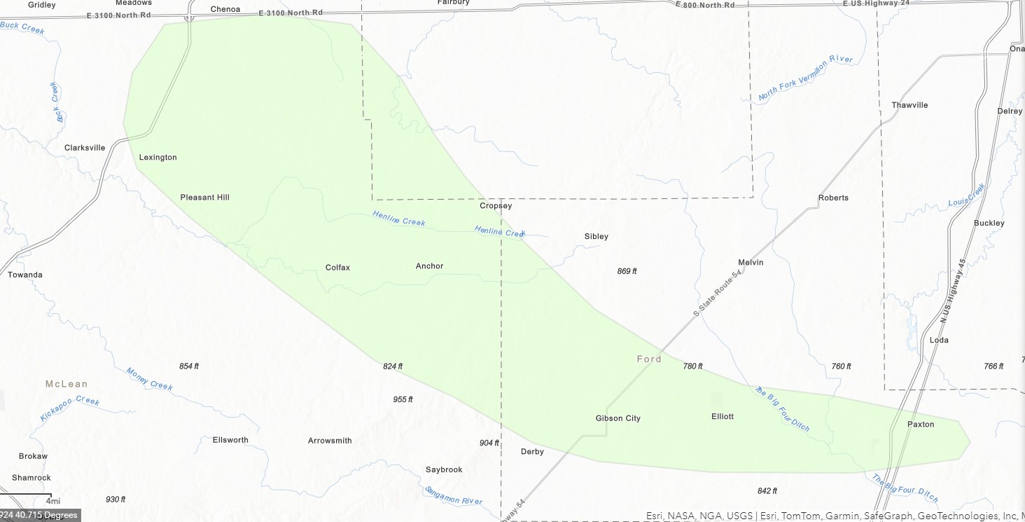
Clusters of severe thunderstorms moved across central Illinois the evening of Thursday, June 13, 2024. These were most focused north of a Quincy to Danville line. The area between Bloomington and Paxton was especially hard hit, where widespread damage occurred due to 60 to 100 mph winds. Five EF-1 tornadoes occurred in parts of McLean and Ford Counties, though analysis continues on the exact tracks. Earlier in the evening, there were also two weak tornadoes in McDonough County. Information from neighboring areas can be obtained from the following links:
|
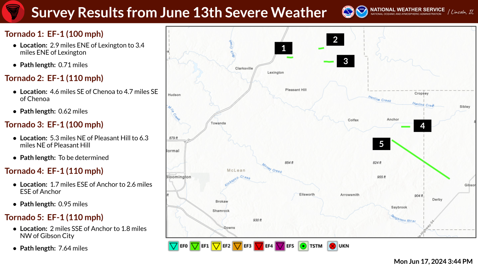 Information on survey results as of Tuesday, June 18 |
Tornadoes
|
Northeast of Lexington
|
||||||||||||||||
|
||||||||||||||||
|
Southeast of Chenoa
|
||||||||||||||||
|
||||||||||||||||
|
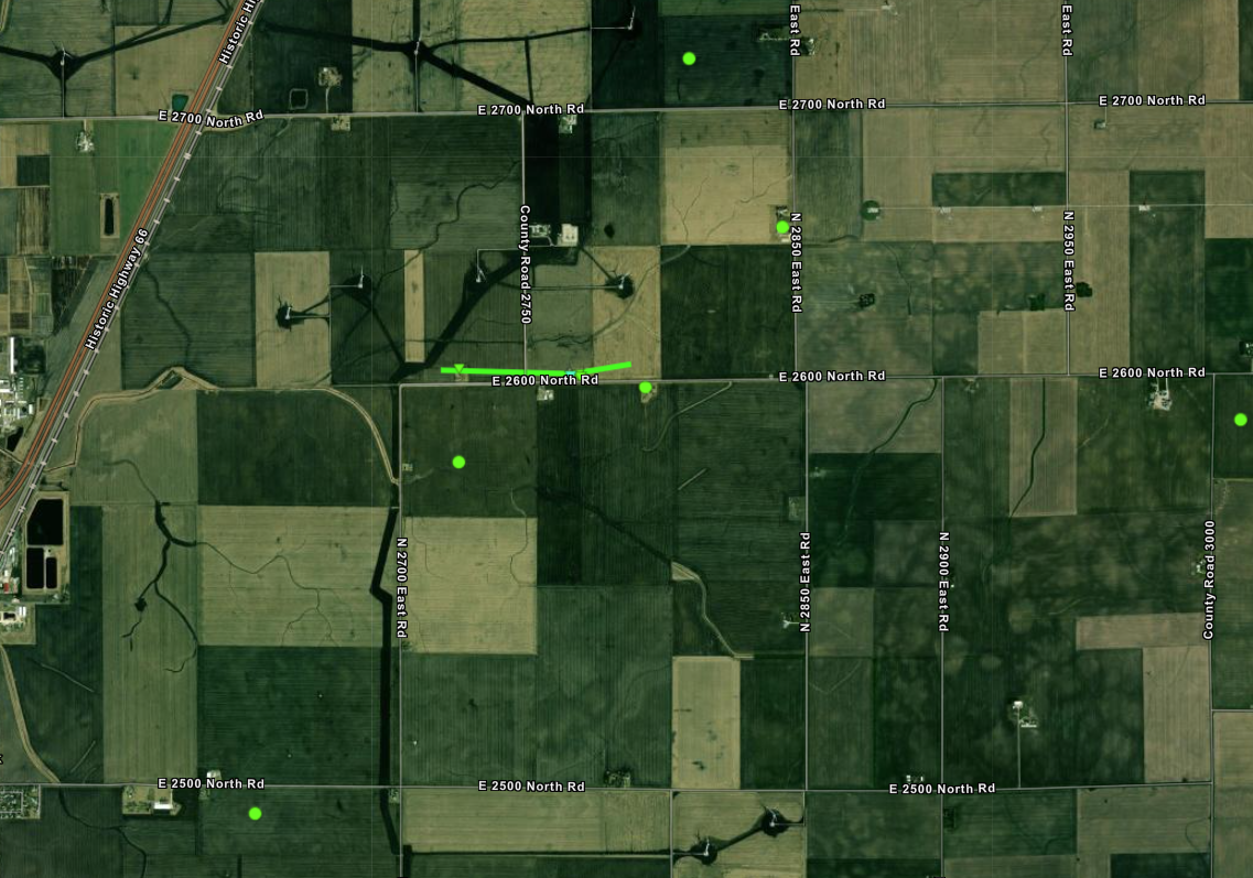
Northeast of Pleasant Hill
|
||||||||||||||||
|
||||||||||||||||
|
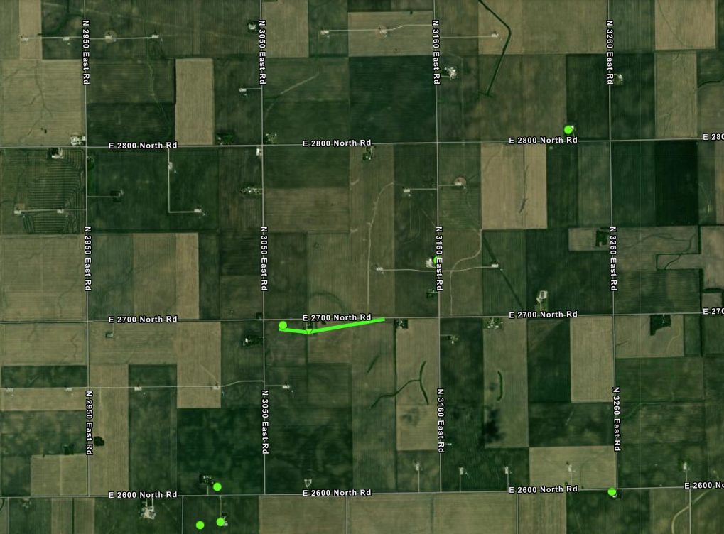
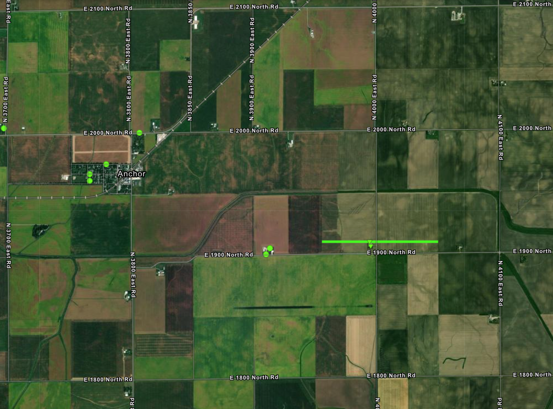
Anchor
|
||||||||||||||||
|
||||||||||||||||
|
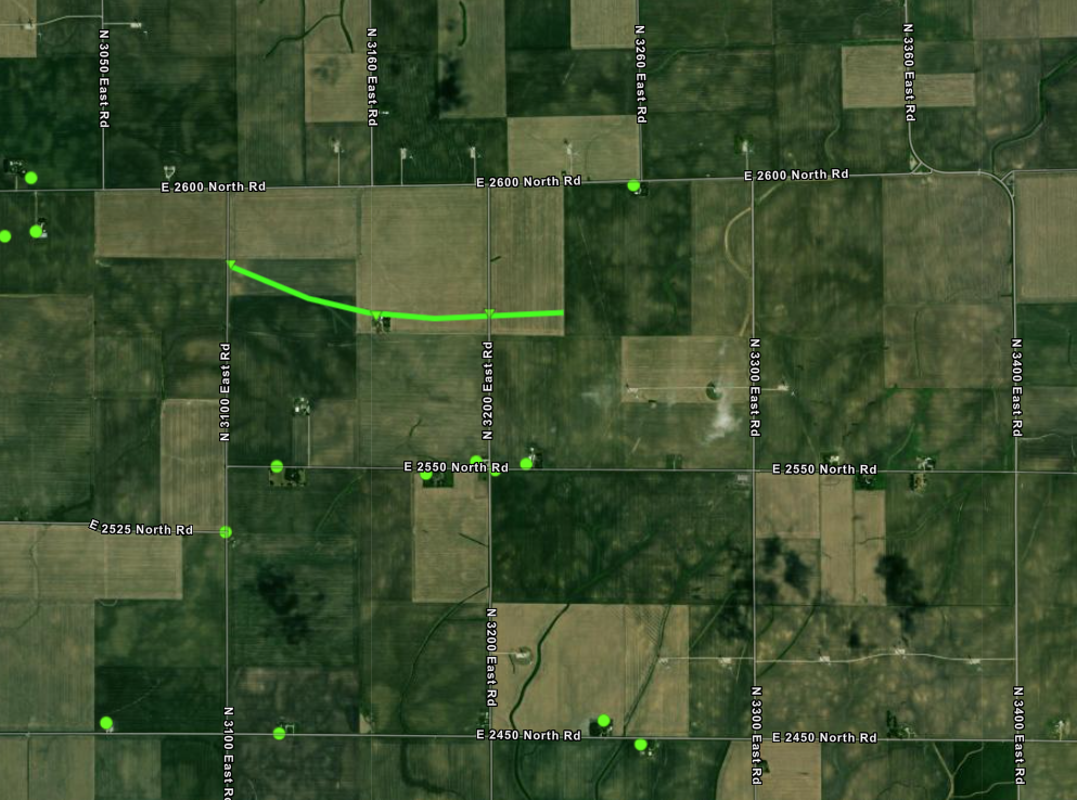
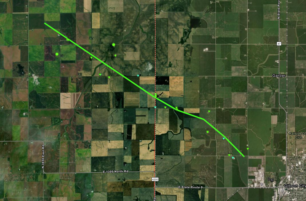
Anchor to Gibson City
|
||||||||||||||||
|
||||||||||||||||
|
Tornado - LOCATION
Track Map 
Downloadable KMZ File |
||||||||||||||||
|
||||||||||||||||
The Enhanced Fujita (EF) Scale classifies tornadoes into the following categories:
| EF0 Weak 65-85 mph |
EF1 Moderate 86-110 mph |
EF2 Significant 111-135 mph |
EF3 Severe 136-165 mph |
EF4 Extreme 166-200 mph |
EF5 Catastrophic 200+ mph |
 |
|||||
Wind:
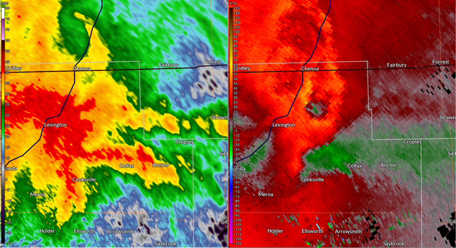
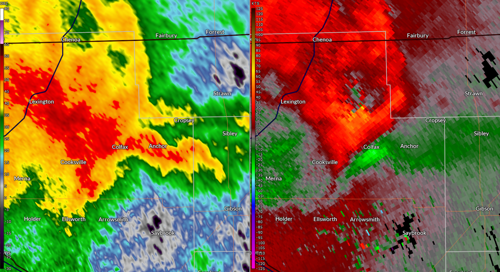
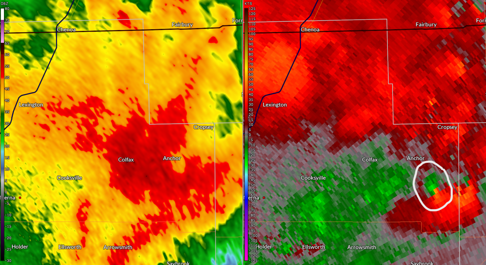
A widespread area of enhanced wind damage occurred in a 10 to 15 mile wide corridor, from northeast McLean County into southern Ford County. The strongest wind gusts were around 100 mph between Lexington and the Livingston County border, with 75-90 mph winds in the Colfax and Anchor areas. Over 30 high-tension electrical transmission towers were severely damaged by the wind. The downburst became more focused as it moved into Ford County.
| Northeast of Lexington | Northeast of Pleasant Hill | Northeast of Lexington | Colfax |
Photos & Video
Header
| Caption (source) |
Caption (source) |
Caption (source) |
Caption (source) |
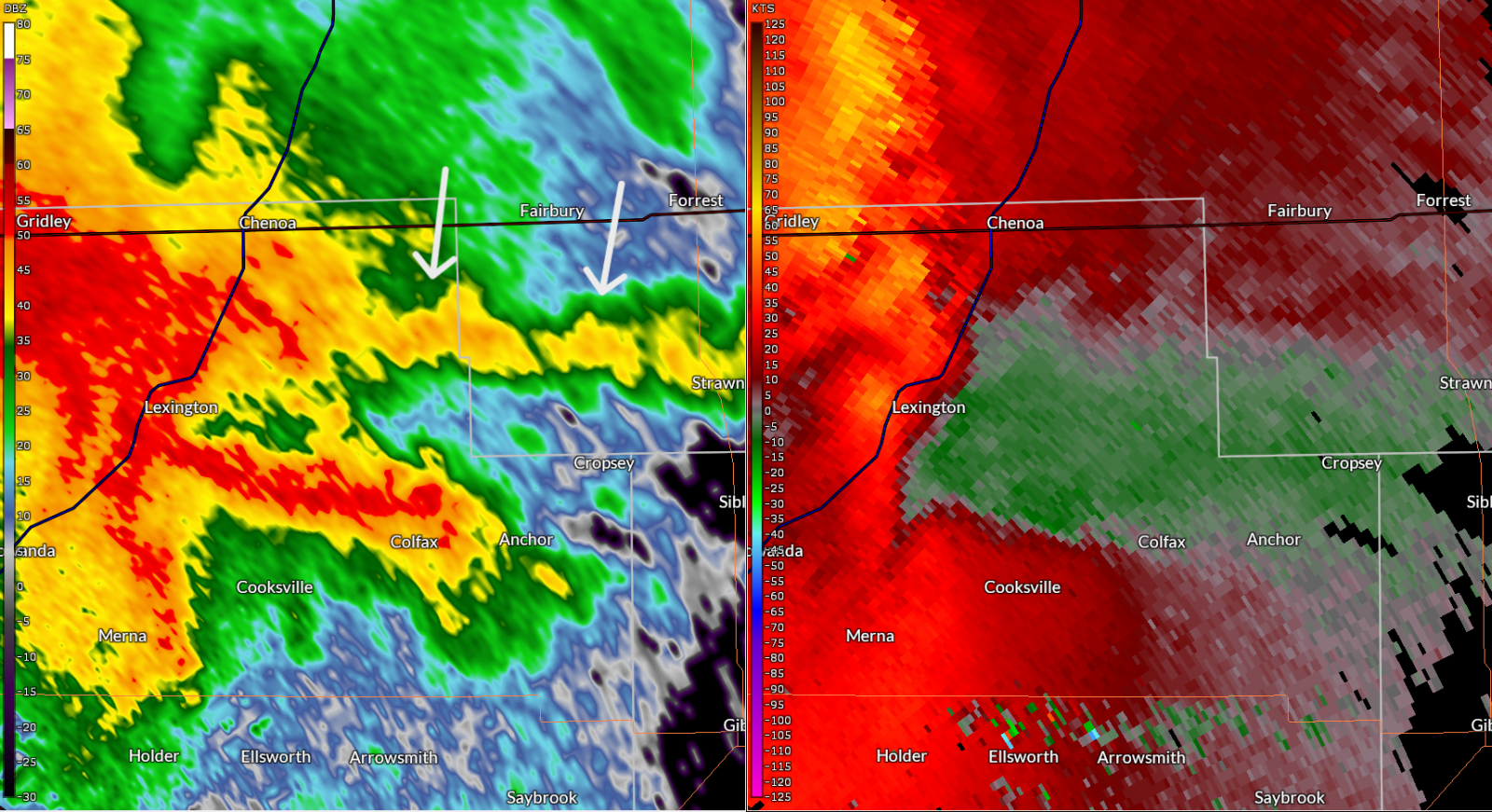
Radar
Evolution of severe storms
 |
 |
 |
 |
| 8:25 pm CDT | 8:30 pm CDT | 8:36 pm CDT | 8:47 pm CDT |
This sequence of radar images is focused over northeast McLean County, with reflectivity on the left half of the image, and storm relative velocity on the right half. Green velocity colors represent motion toward the radar (which is off to the lower left), and red colors show motion away from the radar.
At 8:25 pm, an east-west line of heavier showers had formed, and was feeding into the storms coming in from the west. It is believed this helped enhanced the incoming storms, and caused them to bring stronger winds to the surface. Some circulations began to appear, along with enhanced wind speeds. As the storms approached, no significant rotation was noted, and it is felt the damage in this area was caused by straight-line winds. However, by the time the storms passed Anchor (8:47 pm image), a tornadic circulation had developed, and persisted into Ford County.
Storm Reports
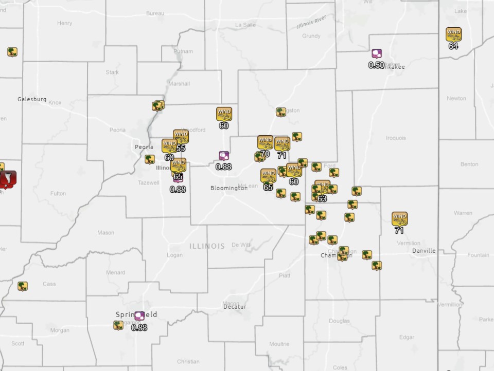
Preliminary Local Storm Report...Summary
National Weather Service Lincoln IL
927 PM CDT Fri Jun 14 2024

..TIME...   ...EVENT...      ...CITY LOCATION...     ...LAT.LON...
..DATE...   ....MAG....      ..COUNTY LOCATION..ST.. ...SOURCE....
            ..REMARKS..

0708 PM     Tstm Wnd Dmg     4 S Beardstown          39.95N 90.44W
06/13/2024                   Cass               IL   Public

            Report from mPING: 1-inch tree limbs broken;
            Shingles blown off.

0743 PM     Tstm Wnd Dmg     2 NNW Groveland         40.63N 89.55W
06/13/2024                   Tazewell           IL   Emergency Mngr

            power line down near interchange of E Muller
            Rd and Springfield Rd.

0745 PM     Hail             Mackinaw                40.53N 89.35W
06/13/2024  M0.88 Inch       Tazewell           IL   Emergency Mngr


0756 PM     Tstm Wnd Dmg     Curran                  39.74N 89.77W
06/13/2024                   Sangamon           IL   Public

            Power line down south of Curran.

0800 PM     Rain             1 E Creve Coeur         40.63N 89.58W
06/13/2024  M1.00 Inch       Tazewell           IL   Trained Spotter


0805 PM     Tstm Wnd Dmg     Chillicothe             40.92N 89.48W
06/13/2024                   Peoria             IL   Public

            3 inch tree limbs down.

0805 PM     Tstm Wnd Dmg     1 SSW Chillicothe       40.91N 89.50W
06/13/2024                   Peoria             IL   Emergency Mngr

            House fire due to power lines down.

0808 PM     Hail             2 S Grandview           39.79N 89.62W
06/13/2024  M0.88 Inch       Sangamon           IL   Broadcast Media


0812 PM     Hail             2 SW Kappa              40.65N 89.03W
06/13/2024  M0.88 Inch       McLean             IL   Emergency Mngr


0815 PM     Tstm Wnd Gst     3 SSE Metamora          40.75N 89.33W
06/13/2024  M55 MPH          Woodford           IL   Public


0820 PM     Tstm Wnd Gst     3 WNW Benson            40.86N 89.17W
06/13/2024  E60 MPH          Woodford           IL   Public


0820 PM     Tstm Wnd Gst     3 S Minonk              40.87N 89.03W
06/13/2024  E60 MPH          Woodford           IL   Public


0825 PM     Tstm Wnd Dmg     1 NNE Lexington         40.65N 88.77W
06/13/2024                   McLean             IL   Emergency Mngr

            Downed power lines north Lexington.

0825 PM     Tstm Wnd Dmg     Lexington               40.64N 88.78W
06/13/2024                   McLean             IL   Emergency Mngr

            Tree down on home.

0828 PM     Flood            2 SW Rome               40.86N 89.52W
06/13/2024                   Peoria             IL   Public

            Report from mPING: Street/road flooding.

0830 PM     Tstm Wnd Gst     2 SSW Chenoa            40.72N 88.74W
06/13/2024  E70 MPH          McLean             IL   Trained Spotter

            Semi trailer turned over on Interstate 55
            just south of Chenoa.

0830 PM     Tstm Wnd Gst     Washington              40.70N 89.41W
06/13/2024  E60 MPH          Tazewell           IL   Public


0833 PM     Tstm Wnd Dmg     Colfax                  40.57N 88.62W
06/13/2024                   McLean             IL   Emergency Mngr

            Numerous large tree limbs down.

0835 PM     Tstm Wnd Dmg     Colfax                  40.56N 88.61W
06/13/2024                   McLean             IL   Emergency Mngr

            Large whole trees down on power lines.

0836 PM     Tstm Wnd Gst     5 ESE Chenoa            40.71N 88.62W
06/13/2024  M71 MPH          McLean             IL   Public

            A personal weather station measured a 71 mph
            wind gust 2 miles south of Weston.

0839 PM     Tstm Wnd Gst     Cooksville              40.54N 88.72W
06/13/2024  M65 MPH          McLean             IL   Public

            Personal weather station KILCOOKS5.

0840 PM     Tstm Wnd Dmg     3 N Ellsworth           40.49N 88.72W
06/13/2024                   McLean             IL   Emergency Mngr

            Tree down across route 9 near the
            Cooksville-Ellsworth Blacktop.

0840 PM     Tstm Wnd Dmg     2 N Mackinaw            40.56N 89.36W
06/13/2024                   Tazewell           IL   Emergency Mngr

            Shingle and siding damage to a house. Time
            estimated by radar.

0840 PM     Tstm Wnd Gst     2 SSW Deer Creek        40.60N 89.35W
06/13/2024  E65 MPH          Tazewell           IL   Broadcast Media


0844 PM     Tstm Wnd Gst     Anchor                  40.57N 88.54W
06/13/2024  E60 MPH          McLean             IL   Emergency Mngr


0845 PM     Tstm Wnd Dmg     Cropsey                 40.61N 88.48W
06/13/2024                   McLean             IL   Public

            Numerous trees down. Time estimated.

0845 PM     Tstm Wnd Dmg     Arrowsmith              40.45N 88.63W
06/13/2024                   McLean             IL   Emergency Mngr

            Numerous trees damaged, with one large tree
            down. Time estimated by radar.

0850 PM     Tstm Wnd Dmg     Saybrook                40.43N 88.53W
06/13/2024                   McLean             IL   Broadcast Media

            Trees and powerlines down. Time estimated
            from radar.

0900 PM     Rain             Wataga                  41.03N 90.28W
06/13/2024  M1.18 Inch       Knox               IL   Trained Spotter

            SWOP observer reported 1.18 inches from 7pm
            to 9pm.

0900 PM     Tstm Wnd Dmg     Foosland                40.36N 88.43W
06/13/2024                   Champaign          IL   Broadcast Media

            Tree down on powerlines. Time estimated from
            radar.

0908 PM     Tstm Wnd Dmg     1 N Fisher              40.33N 88.35W
06/13/2024                   Champaign          IL   Public

            Barn door blown off along route 47 north of
            town. Large tree branch broken off. Time
            estimated from radar.

0910 PM     Tstm Wnd Dmg     Ludlow                  40.39N 88.13W
06/13/2024                   Champaign          IL   Broadcast Media

            Tree blown down. Time estimated from radar.

0911 PM     Tstm Wnd Dmg     Mahomet                 40.20N 88.40W
06/13/2024                   Champaign          IL   Public

            Large trees down and power poles down. Time
            estimated from radar.

0915 PM     Tstm Wnd Dmg     1 NE Lake of the Woods  40.22N 88.35W
06/13/2024                   Champaign          IL   Broadcast Media

            Trees down. Time estimated from radar.

0920 PM     Tstm Wnd Dmg     1 NNE Rantoul           40.32N 88.15W
06/13/2024                   Champaign          IL   Public

            Large tree branch down. Time estimated from
            radar.

0920 PM     Tstm Wnd Dmg     5 SW Thomasboro         40.20N 88.27W
06/13/2024                   Champaign          IL   Public

            Power pole down on county road 2200N between
            1000E and 1100E. Time estimated from radar.

0925 PM     Tstm Wnd Dmg     Urbana                  40.11N 88.20W
06/13/2024                   Champaign          IL   Public

            Two 50 foot trees snapped. Time estimated
            from radar.

0930 PM     Tstm Wnd Dmg     1 NE Saint Joseph       40.12N 88.03W
06/13/2024                   Champaign          IL   Public

            Large tree broken. Chimney blown off a
            farmhouse. Time estimated from radar.

0945 PM     Tstm Wnd Dmg     1 N Homer               40.06N 87.96W
06/13/2024                   Champaign          IL   Public

            Tree fell on a house, causing damage to the
            roof. Time estimated from radar.

0953 PM     Tstm Wnd Dmg     2 NE Urbana             40.14N 88.19W
06/13/2024                   Champaign          IL   Public

            Report from mPING: 1-inch tree limbs broken;
            Shingles blown off.

1003 PM     Flood            Saint Joseph            40.11N 88.05W
06/13/2024                   Champaign          IL   Public

            Report from mPING: Street/road flooding.

1010 PM     Tstm Wnd Gst     Potomac                 40.31N 87.80W
06/13/2024  M71 MPH          Vermilion          IL   Broadcast Media

            Time estimated from radar.

0700 AM     Rain             2 ENE Urbana            40.11N 88.18W
06/14/2024  M1.58 Inch       Champaign          IL   Public

            24 hour total from storms overnight.

0937 AM     Rain             3 N Towanda             40.60N 88.90W
06/14/2024  M1.03 Inch       McLean             IL   Public

            24 hour total from storms last night.

1100 AM     Tstm Wnd Dmg     Lexington               40.64N 88.78W
06/14/2024                   McLean             IL   Public

            2 large trees down.
 |
Media use of NWS Web News Stories is encouraged! Please acknowledge the NWS as the source of any news information accessed from this site. |
|