Overview
|
A derecho (long-lived line of thunderstorms with intense winds) produce widespread wind damage across Iowa, northern Illinois, and northern Indiana on August 10, 2020. Many areas had hurricane-force wind speeds in excess of 75 mph, including some 100-115 mph wind gusts in eastern Iowa. Eleven tornadoes also occurred across northern Illinois. Between the winds and the tornadoes, a widespread region of the Midwest saw extensive damage to trees, power lines, buildings, and vehicles. Event summaries from elsewhere along the track can be found at the following links:
|
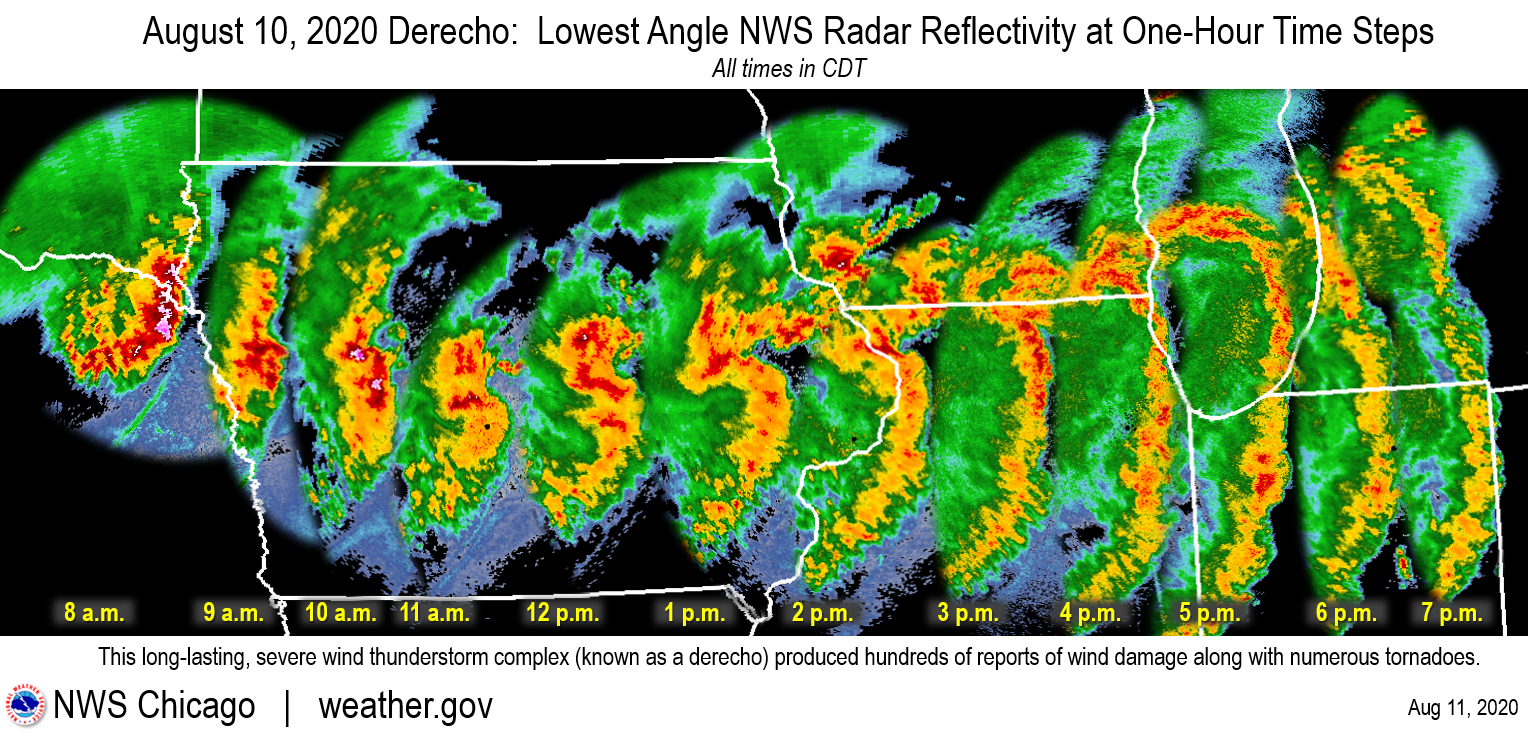 Radar progression of the derecho between 8 am and 7 pm CDT. Image courtesy NWS Chicago. |
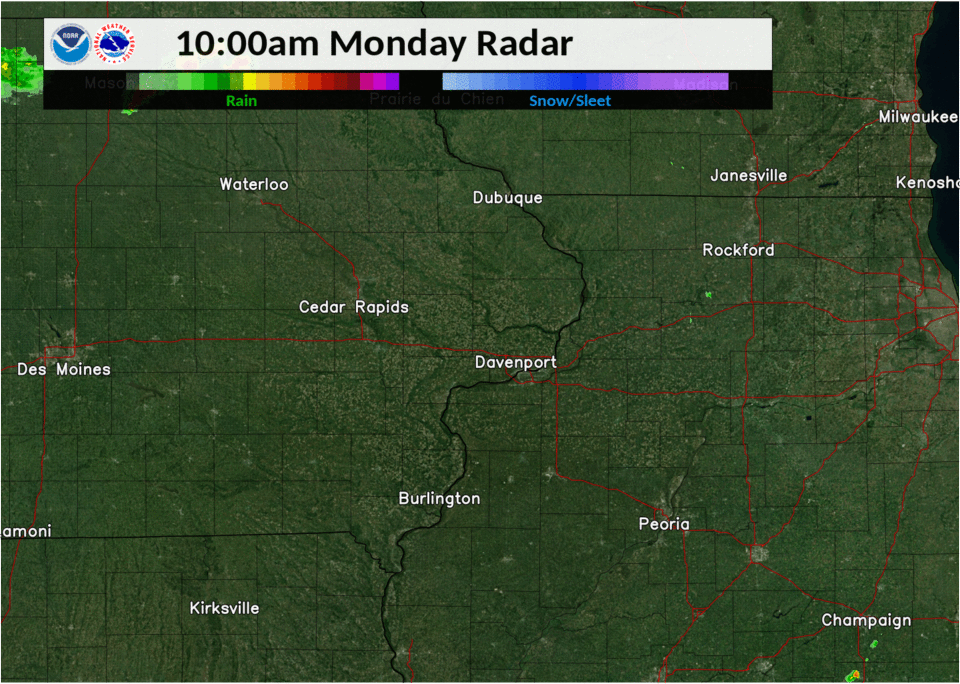
Radar
Progression of derecho across northern Illinois (courtesy NWS Quad Cities):
Storm Reports
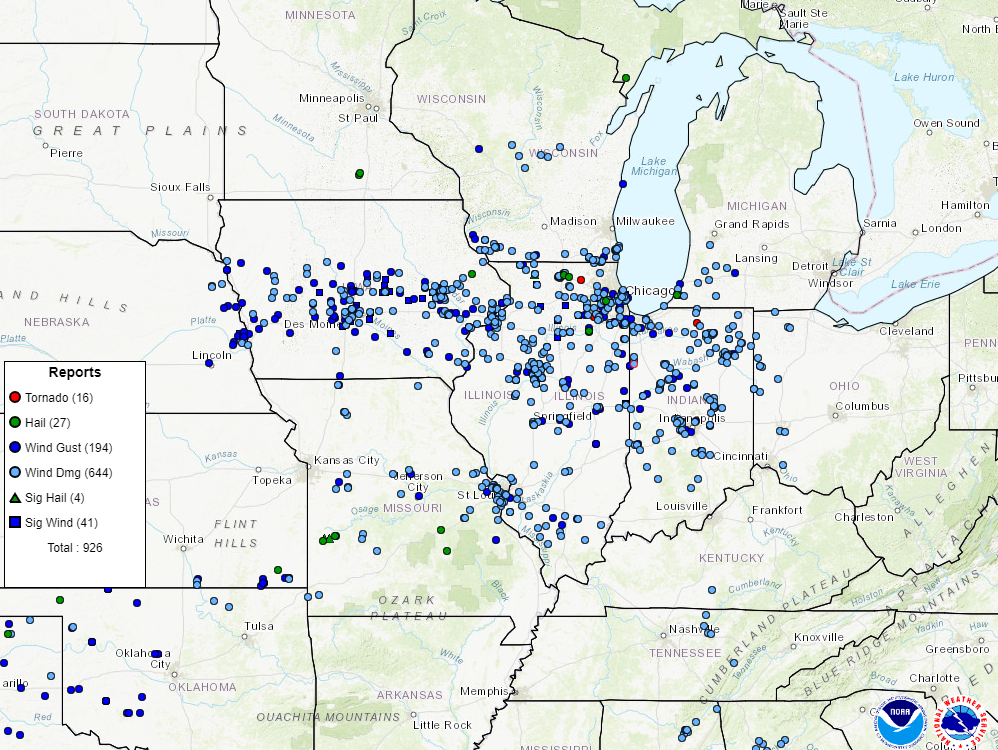
Interactive map from the Storm Prediction Center
PRELIMINARY LOCAL STORM REPORT...SUMMARY
NATIONAL WEATHER SERVICE LINCOLN IL
1048 PM CDT MON AUG 10 2020

..TIME...   ...EVENT...      ...CITY LOCATION...     ...LAT.LON...
..DATE...   ....MAG....      ..COUNTY LOCATION..ST.. ...SOURCE....
            ..REMARKS..

0155 PM     TSTM WND GST     GALESBURG AIRPORT       40.94N 90.43W
08/10/2020  M51.00 MPH       KNOX               IL   AWOS

0200 PM     TSTM WND DMG     GALESBURG               40.95N 90.38W
08/10/2020                   KNOX               IL   FIRE DEPT/RESCUE

            SEVERAL POWER LINES AND TREE BRANCHES DOWN.

0215 PM     TSTM WND DMG     ELMIRA                  41.18N 89.83W
08/10/2020                   STARK              IL   LAW ENFORCEMENT

            SEVERAL POWER LINES AND TREES BLOWN DOWN BETWEEN
            210-220PM.

0215 PM     TSTM WND DMG     BRADFORD                41.18N 89.66W
08/10/2020                   STARK              IL   LAW ENFORCEMENT

            SEVERAL POWER LINES AND TREES BLOWN DOWN BETWEEN
            210-220PM.

0215 PM     TSTM WND DMG     WYOMING                 41.06N 89.77W
08/10/2020                   STARK              IL   LAW ENFORCEMENT

            SEVERAL POWER LINES AND TREES BLOWN DOWN BETWEEN
            210-220PM.

0215 PM     TSTM WND DMG     TOULON                  41.09N 89.86W
08/10/2020                   STARK              IL   LAW ENFORCEMENT

            SEVERAL POWER LINES AND TREES BLOWN DOWN BETWEEN
            210-220PM.

0217 PM     TSTM WND GST     MARIETTA                40.50N 90.39W
08/10/2020  E55.00 MPH       FULTON             IL   EMERGENCY MNGR

0220 PM     TSTM WND DMG     2 SSW ELMWOOD           40.76N 89.99W
08/10/2020                   PEORIA             IL   EMERGENCY MNGR

            TEN INCH TREE ACROSS IL-78 NEAR GRAHAM CHAPEL ROAD.
            DELAYED REPORT.

0222 PM     TSTM WND GST     CUBA                    40.49N 90.19W
08/10/2020  E55.00 MPH       FULTON             IL   EMERGENCY MNGR

0223 PM     TSTM WND GST     FARMINGTON              40.70N 90.00W
08/10/2020  E60.00 MPH       FULTON             IL   EMERGENCY MNGR

            REPORTED WIND GUSTS OF 50-60 MPH. WIND GUSTS REMAINED AT
            THIS LEVEL FOR ABOUT FIVE MINUTES.

0225 PM     TSTM WND DMG     WNW DUNLAP              40.86N 89.68W
08/10/2020                   PEORIA             IL   EMERGENCY MNGR

            TREE WAS ON HOME AT 4TH ST AND BIRCH AND TREE BRANCHES ON
            HOME AT 5TH AND BIRCH. DELAYED REPORT.

0228 PM     TSTM WND DMG     KICKAPOO                40.80N 89.75W
08/10/2020                   PEORIA             IL   BROADCAST MEDIA

            LARGE TREE UPROOTED

0229 PM     TSTM WND DMG     5 NNW PEORIA            40.81N 89.64W
08/10/2020                   PEORIA             IL   EMERGENCY MNGR

            EIGHT INCH TREE DOWN ON HOUSE ON 3300 BLOCK ALTA LANE.
            DELAYED REPORT.

0230 PM     TSTM WND DMG     CANTON                  40.56N 90.04W
08/10/2020                   FULTON             IL   PUBLIC

            TREE SNAPPED AT BASE

0230 PM     TSTM WND GST     HANNA CITY              40.69N 89.79W
08/10/2020  M61.00 MPH       PEORIA             IL   EMERGENCY MNGR

0232 PM     TSTM WND DMG     FARMINGTON              40.57N 90.18W
08/10/2020                   FULTON             IL   EMERGENCY MNGR

            TREE FELL ON HOUSE

0235 PM     TSTM WND DMG     CANTON                  40.56N 90.04W
08/10/2020                   FULTON             IL   MESONET

            A PORCH ROOF WAS BLOWN OFF ON THE WEST SIDE OF CANTON.

0235 PM     TSTM WND DMG     4 NW EAST PEORIA        40.72N 89.60W
08/10/2020                   PEORIA             IL   BROADCAST MEDIA

            LARGE BILLBOARD WAS BLOWN OVER NEAR THE INTERSECTION OF
            GIFT AVENUE AND SHERIDAN ROAD. STEEL BEAMS SUPPORTING THE
            BILLBOARD BENT ABOUT HALFWAY. DELAYED REPORT.

0235 PM     TSTM WND DMG     4 NNW EAST PEORIA       40.73N 89.57W
08/10/2020                   PEORIA             IL   EMERGENCY MNGR

            EIGHT INCH TREE LIMBS DOWN AT WAR MEMORIAL DRIVE AND
            GRAVE AVE. DELAYED REPORT.

0235 PM     TSTM WND DMG     3 ENE PEORIA            40.76N 89.56W
08/10/2020                   PEORIA             IL   EMERGENCY MNGR

            MULTIPLE TREE LIMBS DOWN AND POWER POLE PARTIALLY DOWN ON
            5400 BLOCK OF GALENA ROAD. DELAYED REPORT.

0235 PM     TSTM WND DMG     PEORIA HEIGHTS          40.75N 89.57W
08/10/2020                   PEORIA             IL   BROADCAST MEDIA

            DAMAGE TO A HOME UNDER CONSTRUCTION
0235 PM     TSTM WND DMG     1 NW HOPEWELL           40.99N 89.47W
08/10/2020                   MARSHALL           IL   PUBLIC

            8 INCH DIAMETER TREE BLOWN DOWN. DELAYED SWOP REPORT.
0237 PM     TSTM WND DMG     WEST PEORIA             40.70N 89.63W
08/10/2020                   PEORIA             IL   EMERGENCY MNGR

            TWO TREES BLOWN DOWN. ONE RESULTED IN A ROAD BEING
            BLOCKED.
0237 PM     TSTM WND DMG     BARTONVILLE             40.64N 89.66W
08/10/2020                   PEORIA             IL   PUBLIC

            PICNIC SHELTER DESTROYED. DELAYED REPORT.
0238 PM     TSTM WND DMG     1 E GERMANTOWN HILLS    40.77N 89.45W
08/10/2020                   WOODFORD           IL   BROADCAST MEDIA

            PART OF THE GERMANTOWN HILLS MIDDLE SCHOOL ROOF WAS BLOWN
            OFF. DELAYED REPORT.

0240 PM     TSTM WND DMG     GERMANTOWN HILLS        40.77N 89.47W
08/10/2020                   WOODFORD           IL   BROADCAST MEDIA

            ROOF DAMAGE TO MIDDLE SCHOOL. REPORTED BY WEEK-TV.

0240 PM     TSTM WND DMG     1 SW ELMWOOD            40.77N 89.98W
08/10/2020                   PEORIA             IL   EMERGENCY MNGR

            TREE DOWN ON GRAHAM CHAPEL ROAD AND IL ROUTE 78.

0240 PM     TSTM WND DMG     WASHBURN                40.92N 89.29W
08/10/2020                   WOODFORD           IL   EMERGENCY MNGR

            MULTIPLE TREES AND POWER LINES DOWN. TREE DOWN ON A
            HOUSE, RESIDENTS HAD TO BE HELPED OUT OF HOME.

0240 PM     TSTM WND DMG     5 NE EAST PEORIA        40.72N 89.48W
08/10/2020                   TAZEWELL           IL   PUBLIC

            TWO TREES BROKEN NEAR THE BASE

0240 PM     TSTM WND DMG     HENRY                   41.11N 89.36W
08/10/2020                   MARSHALL           IL   EMERGENCY MNGR

            TREE FELL ON HOUSE ON MAIN ST. MANY 6-8 INCH DIAMETER
            BRANCHES DOWN. SCHOOL ST BLOCKED BY DOWNED TREES.

0240 PM     TSTM WND DMG     METAMORA                40.79N 89.36W
08/10/2020                   WOODFORD           IL   PUBLIC

            SEVERAL TREES AND FENCES BLOWN DOWN

0240 PM     TSTM WND GST     2 N PEORIA              40.77N 89.61W
08/10/2020  E60.00 MPH       PEORIA             IL   BROADCAST MEDIA

            WIND GUSTS UP TO 60MPH LASTED FOR APPROXIMATELY FIVE
            MINUTES.

0240 PM     TSTM WND DMG     LACON                   41.02N 89.41W
08/10/2020                   MARSHALL           IL   EMERGENCY MNGR

            TREES AND POWER LINES DOWN ON 2ND STREET.

0242 PM     TSTM WND GST     SPRING BAY              40.82N 89.53W
08/10/2020  E65.00 MPH       WOODFORD           IL   EMERGENCY MNGR

0242 PM     TSTM WND DMG     CANTON                  40.56N 90.04W
08/10/2020                   FULTON             IL   TRAINED SPOTTER

            MANY 6 INCH DIAMETER TREE BRANCHES DOWN.

0242 PM     TSTM WND DMG     SPRING BAY              40.82N 89.53W
08/10/2020                   WOODFORD           IL   EMERGENCY MNGR

            ROOF BLOWN OFF A LARGE SHED

0243 PM     TSTM WND GST     PEORIA INTERNATIONAL AI 40.67N 89.68W
08/10/2020  M59.00 MPH       PEORIA             IL   ASOS

0245 PM     TSTM WND DMG     HAVANA                  40.30N 90.06W
08/10/2020                   MASON              IL   PUBLIC

            TREES DOWN

0245 PM     TSTM WND DMG     HENRY                   41.11N 89.36W
08/10/2020                   MARSHALL           IL   EMERGENCY MNGR

            TWO LARGE TREES, APPROXIMATELY 10 INCHES IN DIAMETER,
            BLOWN DOWN.
0244 PM     TSTM WND DMG     BELLEVUE                40.69N 89.67W
08/10/2020                   PEORIA             IL   EMERGENCY MNGR

            TREE DOWN ON POWERLINES ON HEUERMANN RD. TIME ESTIMATED
            BY RADAR.

0245 PM     TSTM WND DMG     BARTONVILLE             40.64N 89.66W
08/10/2020                   PEORIA             IL   EMERGENCY MNGR

            TREE DOWN ON POWERLINES ON FAIRVIEW DRIVE. TIME ESTIMATED
            BY RADAR.
0247 PM     TSTM WND DMG     1 NW MORTON             40.62N 89.48W
08/10/2020                   TAZEWELL           IL   PUBLIC

            POWER POLE SNAPPED NEAR JEFFERSON AND WESTSHORE

0248 PM     TSTM WND DMG     HAVANA                  40.30N 90.06W
08/10/2020                   MASON              IL   EMERGENCY MNGR

            LARGE TREE BLOWN DOWN. POWER LINES ALSO DOWN.

0248 PM     TSTM WND DMG     EUREKA                  40.72N 89.28W
08/10/2020                   WOODFORD           IL   EMERGENCY MNGR

            POWER LINES BLOWN DOWN, POWER OUT IN TOWN.

0249 PM     TSTM WND GST     GROVELAND               40.61N 89.53W
08/10/2020  M52.00 MPH       TAZEWELL           IL   EMERGENCY MNGR

0250 PM     TSTM WND DMG     1 S MORTON              40.60N 89.47W
08/10/2020                   TAZEWELL           IL   NWS EMPLOYEE

            SIX INCH TREE BRANCHES BLOWN DOWN

0250 PM     TSTM WND GST     1 S MORTON              40.60N 89.47W
08/10/2020  E65.00 MPH       TAZEWELL           IL   NWS EMPLOYEE

0253 PM     TSTM WND DMG     1 SSW PEORIA            40.73N 89.62W
08/10/2020                   PEORIA             IL   STORM CHASER

            MULTIPLE LARGE TREE LIMBS, APPROXIMATELY 20 FEET LONG,
            DOWN. POWER LINES ALSO DOWN. SOME STREETS BLOCKED BY
            DOWNED TREES. NO STRUCTURAL DAMAGE REPORTED.

0256 PM     TSTM WND DMG     PEKIN                   40.57N 89.63W
08/10/2020                   TAZEWELL           IL   EMERGENCY MNGR

            LIVE TREE, OVER ONE FOOT IN DIAMETER, BLOWN DOWN.

0258 PM     TSTM WND GST     MORTON                  40.61N 89.47W
08/10/2020  M53.00 MPH       TAZEWELL           IL   PUBLIC

0258 PM     TSTM WND GST     1 SSW MORTON            40.60N 89.48W
08/10/2020  M62.00 MPH       TAZEWELL           IL   STORM CHASER

            MEASURED WIND GUSTS BETWEEN 55-62MPH OCCURRED BETWEEN 250
            AND 258PM.

0300 PM     TSTM WND DMG     1 SW PEKIN              40.56N 89.64W
08/10/2020                   TAZEWELL           IL   PUBLIC

            LARGE TREE DOWN BLOCKING A ROAD

0300 PM     TSTM WND DMG     HOPEDALE                40.42N 89.42W
08/10/2020                   TAZEWELL           IL   PUBLIC

            GRAIN BIN DAMAGED

0306 PM     TSTM WND DMG     3 E SOUTH PEKIN         40.50N 89.59W
08/10/2020                   TAZEWELL           IL   STORM CHASER

            10 INCH DIAMETER TREE BRANCHES DOWN

0306 PM     TSTM WND GST     3 E SOUTH PEKIN         40.50N 89.59W
08/10/2020  E80.00 MPH       TAZEWELL           IL   STORM CHASER

0310 PM     TSTM WND DMG     2 NE HAVANA             40.32N 90.03W
08/10/2020                   MASON              IL   EMERGENCY MNGR

            DOWNED POWER LINES CAUSED A FOUR ACRE FIELD FIRE

0311 PM     TSTM WND DMG     2 WNW BLOOMINGTON       40.49N 89.00W
08/10/2020                   MCLEAN             IL   EMERGENCY MNGR

            LARGE TREE LIMB WENT THROUGH ROOF ON 700 BLOCK OF W
            WALNUT. RAFTERS DAMAGED. DELAYED REPORT. TIME ESTIMATED.

0311 PM     TSTM WND DMG     1 WNW BLOOMINGTON       40.49N 89.00W
08/10/2020                   MCLEAN             IL   TRAINED SPOTTER

            LARGE TREE LIMB DOWN

0312 PM     TSTM WND GST     TOWANDA                 40.56N 88.90W
08/10/2020  M58.00 MPH       MCLEAN             IL   PUBLIC

0315 PM     TSTM WND DMG     NORMAL                  40.52N 89.00W
08/10/2020                   MCLEAN             IL   NWS EMPLOYEE

            LARGE TREE UPROOTED AND DOWN ON TWO HOMES NEAR
            CONSTITUTION TRAIL. ONE LARGE TREE BRANCH ALSO DOWN.

0315 PM     TSTM WND DMG     3 S BLOOMINGTON         40.43N 88.96W
08/10/2020                   MCLEAN             IL   EMERGENCY MNGR

            20 INCH TREE LIMB DOWN. NO STRUCTURAL DAMAGE REPORTED.
            TIME ESTIMATED.

0315 PM     TSTM WND DMG     DUNLAP                  40.86N 89.68W
08/10/2020                   PEORIA             IL   EMERGENCY MNGR

            TREE DOWN ON HOUSE AT 1ST AND 4TH ST. TREE BRANCHES DOWN
            AT 5TH AND ATLANTA.

0316 PM     TSTM WND GST     HAVANA                  40.30N 90.06W
08/10/2020  E50.00 MPH       MASON              IL   PUBLIC

0316 PM     TSTM WND DMG     EAST PEORIA             40.67N 89.55W
08/10/2020                   TAZEWELL           IL   BROADCAST MEDIA

            NUMEROUS MATURE BRANCHES DOWN NEAR VETERANS AND
            BLOOMINGTON ROAD.

0317 PM     TSTM WND GST     2 WNW TOWANDA           40.57N 88.94W
08/10/2020  M57.00 MPH       MCLEAN             IL   MESONET

            APRS MESONET

0320 PM     TSTM WND GST     BLOOMINGTON AIRPORT     40.48N 88.92W
08/10/2020  M64.00 MPH       MCLEAN             IL   AWOS

0326 PM     TSTM WND GST     NORMAL                  40.52N 89.00W
08/10/2020  M51.00 MPH       MCLEAN             IL   EMERGENCY MNGR

            MEASURED AT ILLINOIS STATE UNIVERSITY

0328 PM     TSTM WND DMG     ALTA                    40.82N 89.63W
08/10/2020                   PEORIA             IL   EMERGENCY MNGR

            EIGHT INCH TREE LIMBS DOWN

0330 PM     TSTM WND DMG     MASON CITY              40.20N 89.70W
08/10/2020                   MASON              IL   EMERGENCY MNGR

            ONE FOOT TREE LIMB DOWN ON CAR

0330 PM     TSTM WND DMG     MASON CITY              40.20N 89.70W
08/10/2020                   MASON              IL   EMERGENCY MNGR

            POWER POLE IN AMEREN PARKING LOT FELL ON CAR.

0340 PM     TSTM WND DMG     PEORIA                  40.74N 89.61W
08/10/2020                   PEORIA             IL   EMERGENCY MNGR

            10 INCH TREE DOWN AND EIGHT INCH TREE BRANCHES DOWN

0345 PM     TSTM WND GST     W SPRINGFIELD           39.80N 89.64W
08/10/2020  M58.00 MPH       SANGAMON           IL   TRAINED SPOTTER

0345 PM     TSTM WND DMG     3 N SPRINGFIELD         39.85N 89.65W
08/10/2020                   SANGAMON           IL   AMATEUR RADIO

            18 INCH DIAMETER TREE UPROOTED.

0345 PM     TSTM WND DMG     BELLFLOWER              40.34N 88.53W
08/10/2020                   MCLEAN             IL   EMERGENCY MNGR

            POWER POLES DAMAGED

0345 PM     TSTM WND DMG     RIVERTON                39.85N 89.54W
08/10/2020                   SANGAMON           IL   UTILITY COMPANY

            POWER POLES DOWN ON S 9TH ST.

0345 PM     TSTM WND DMG     1 NNW SPRINGFIELD       39.82N 89.66W
08/10/2020                   SANGAMON           IL   EMERGENCY MNGR

            POWER LINE DOWN DUE TO 36 INCH DIAMETER TREE BEING
            UPROOTED. TREE WAS PARTIALLY ROTTEN IN THE MIDDLE. TIME
            ESTIMATED BY RADAR.

0350 PM     TSTM WND DMG     1 SE LANE               40.12N 88.84W
08/10/2020                   DE WITT            IL   MESONET

            TWO LARGE TREES WERE BLOWN DOWN...ONE OF WHICH FELL ONTO
            A GRAIN BIN.

0350 PM     TSTM WND DMG     SPRINGFIELD             39.80N 89.64W
08/10/2020                   SANGAMON           IL   EMERGENCY MNGR

            POWER LINES DOWN AT 9TH AND CARPENTER. TIME ESTIMATED BY
            RADAR.

0351 PM     TSTM WND GST     1 N DAWSON              39.87N 89.46W
08/10/2020  M60.00 MPH       SANGAMON           IL   STORM CHASER

            MEASURED WITH HANDHELD ANEMOMETER

0357 PM     TSTM WND DMG     LE ROY                  40.34N 88.76W
08/10/2020                   MCLEAN             IL   TRAINED SPOTTER

            6-8 INCH TREE LIMBS DOWN
0400 PM     TSTM WND DMG     WARRENSBURG             39.93N 89.06W
08/10/2020                   MACON              IL   TRAINED SPOTTER

            TREE DOWN ACROSS A ROAD. TIME ESTIMATED BY RADAR. DELAYED
            REPORT.
0410 PM     TSTM WND DMG     BLUE MOUND              39.70N 89.12W
08/10/2020                   MACON              IL   EMERGENCY MNGR

            TREE FELL ON HOUSE

0410 PM     TSTM WND DMG     DECATUR                 39.85N 88.93W
08/10/2020                   MACON              IL   EMERGENCY MNGR

            12 INCH LIMB DOWN. TIME ESTIMATED BY RADAR.

0420 PM     TSTM WND DMG     URBANA                  40.11N 88.21W
08/10/2020                   CHAMPAIGN          IL   PUBLIC

            TWO LARGE TREES DOWN. SHINGLES DAMAGED.

0423 PM     TSTM WND GST     DECATUR AIRPORT         39.83N 88.87W
08/10/2020  M61.00 MPH       MACON              IL   ASOS

0425 PM     TSTM WND DMG     URBANA                  40.11N 88.21W
08/10/2020                   CHAMPAIGN          IL   EMERGENCY MNGR

            TREE DOWN ON A HOUSE

0425 PM     TSTM WND DMG     URBANA                  40.11N 88.21W
08/10/2020                   CHAMPAIGN          IL   EMERGENCY MNGR

            TREE DOWN ON A GARAGE

0425 PM     TSTM WND GST     ROSSVILLE               40.38N 87.67W
08/10/2020  E60.00 MPH       VERMILION          IL   EMERGENCY MNGR

            WIND GUSTS ESTIMATED AT 50-60MPH.

0425 PM     TSTM WND DMG     CHAMPAIGN               40.11N 88.26W
08/10/2020                   CHAMPAIGN          IL   EMERGENCY MNGR

            TREE DOWN ON A HOUSE

0425 PM     TSTM WND GST     WILLARD AIRPORT         40.04N 88.28W
08/10/2020  M60.00 MPH       CHAMPAIGN          IL   ASOS

0430 PM     TSTM WND GST     3 SSE URBANA            40.07N 88.18W
08/10/2020  M62.00 MPH       CHAMPAIGN          IL   MESONET

            ARPS MESONET

0440 PM     TSTM WND DMG     1 ESE OAKWOOD           40.10N 87.76W
08/10/2020                   VERMILION          IL   EMERGENCY MNGR

            TWO LARGE TREES DOWN BLOCKING US 150.

0443 PM     TSTM WND GST     2 NNW DANVILLE          40.17N 87.63W
08/10/2020  M75.00 MPH       VERMILION          IL   EMERGENCY MNGR

0450 PM     TSTM WND DMG     DANVILLE                40.14N 87.62W
08/10/2020                   VERMILION          IL   EMERGENCY MNGR

            NUMEROUS TREES AND POWER LINES DOWN THROUGHOUT DANVILLE.
            SEVERAL STREETS BLOCKED.

0509 PM     TSTM WND GST     COLES COUNTY AIRPORT    39.48N 88.28W
08/10/2020  M60.00 MPH       COLES              IL   ASOS

            CORRECTED TIME

0527 PM     TSTM WND DMG     10 SE PARIS             39.51N 87.56W
08/10/2020                   EDGAR              IL   BROADCAST MEDIA

            LARGE TREE LIMBS SNAPPED

0647 PM     HAIL             1 NW XENIA              38.65N 88.65W
08/10/2020  E0.75 INCH       CLAY               IL   EMERGENCY MNGR

            DIME SIZED HAIL

0917 PM     HEAVY RAIN       CLINTON                 40.15N 88.96W
08/10/2020  M1.00 INCH       DE WITT            IL   NWS EMPLOYEE
Additional Information
The Forecast
 |
 |
 |
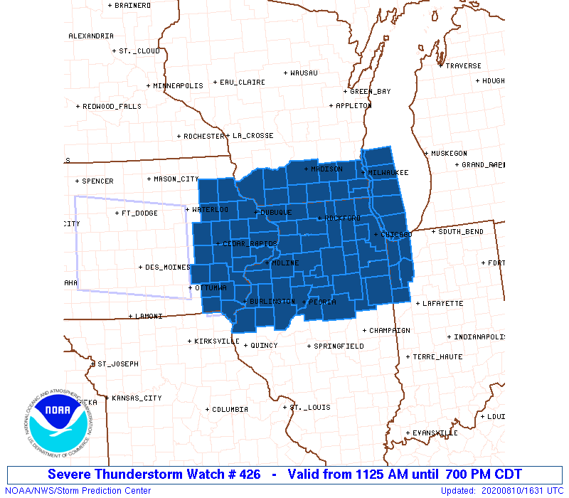
| Severe wind outlook from the Storm Prediction Center at 11 am. Hatched area indicates potential for winds >75 mph. | Severe Thunderstorm Watch issued at 11:25 am. This was labeled as a rare "Particularly Dangerous Situation" watch. | Locations of the severe weather reports vs. the 11 am outlook from the Storm Prediction Center |
About Derechos
According to the Storm Prediction Center, a derecho (pronounced duh-REY-cho) is a widespread, long-lived wind storm associated with a band of rapidly moving thunderstorms. The term was originated by Dr. Gustavus Hinrichs of the University of Iowa, first appearing in the American Meteorological Journal in 1888; he coined the term to distinguish straight-line winds from the damage caused by tornadoes (the word "derecho" comes from the Spanish term meaning "direct" or "straight ahead").
By definition, a derecho includes winds of at least 58 mph along most of its length. While most gusts are below 100 mph, occasionally gusts as high as 130 mph (the strength of a strong EF-2 tornado) have been recorded. The swath of wind damage is at least 250 miles in length.
Some Other Derechos Affecting Central Illinois
These summaries are courtesy of the Storm Prediction Center.
 |
Media use of NWS Web News Stories is encouraged! Please acknowledge the NWS as the source of any news information accessed from this site. |
|

