 |
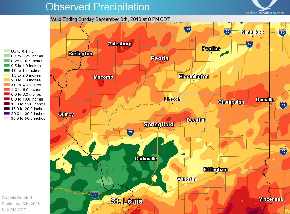
A stationary front combined with the remains of Tropical Storm Gordon, to produce several periods of heavy rain across central and southeast Illinois from Wednesday, September 6th through early Sunday, September 9th. The map at left shows the total for the 7 day period ending Sunday evening. Several heavy pockets of rain occurred, with widespread 3-6 inch totals west of the Illinois River and from near Jacksonville to Danville. Much of that rain fell on the 6th and 7th. In southeast Illinois, the totals were more directly influenced by Gordon, and amounts in parts of Clay, Richland and Lawrence Counties exceeded 10 inches in a few cases! Public reports included 10 inches in Noble, 9.8 inches near Birds, and 9 inches in Olney. Most of this fell late on the 7th and into the evening on the 8th.
|
Public Information Statement
National Weather Service Lincoln IL
850 PM CDT Sun Sep 9 2018

...OFFICIAL RAINFALL REPORTS FROM THE LAST 7 DAYS...

Cooperative and airport observing stations:
(NOTE...The data listed below are preliminary, until certified by
the National Centers for Environmental Information.)

 Daily precipitation ending at 7 AM on:
                   09/03  09/04  09/05  09/06  09/07  09/08  09/09
                   -----  -----  -----  -----  -----  -----  -----
 Altona            0.03   0.65   0.00   0.79   1.27   0.90   0.06
 Arthur 1W         0.00   0.00   0.00   0.00   0.22   2.28      M
 Athens 4SW        0.00   0.00   0.00   0.16   0.11   2.37      M
 Avon              0.00      T   0.00   1.49   1.90   0.62   0.00
 Beecher City      0.00      M   0.00   0.00   0.00   0.78   1.01
 Bloomington       0.00   0.00   0.00      T   0.36   0.79   0.10
 Lawrenceville 2W  0.00   0.00   0.00   0.00   0.19   3.81   4.27
 Buffalo           0.00      M   0.00      M      M   4.07   0.31
 Canton            0.14   0.05   0.00   0.00   1.84   1.07   1.59
 Casey             0.00   0.00   0.00   0.00   0.07   1.95   1.36
 Cisco             0.00   0.00   0.00   0.00   0.04   1.43      M
 Clay City 6SSE    0.00   0.00   0.00      M      M   4.82   5.00
 Congerville 2NW   0.00   0.00   0.00   0.00   0.86   0.34   0.85
 Effingham 3SW     0.00   0.00   0.00   0.00   0.00   1.06   1.61
 Effingham SE      0.00   0.00   0.00   0.00   0.00   2.00   2.00
 Eureka            0.00   0.00   0.00   0.00   0.17   2.49   0.86
 Fisher            0.00   0.00   0.00   0.00   1.51   2.48   0.24
 Flora             0.00   0.00   0.00   0.15   0.03   1.74   2.56
 Galesburg         0.00   0.61   0.00   1.54   3.48   0.90      T
 Havana               T   0.04   0.00   0.76   0.63   1.46   0.02
 Jacksonville #2   0.00   0.00   0.00      T   0.13   2.42   0.11
 Kincaid 3W        0.00   0.00   0.00   0.00   0.06   1.12   0.22
 Knoxville         0.05   0.15   0.00   2.82   2.97   0.85   0.00
 Lacon             0.02   0.07   0.00   1.55   1.08   0.22   0.00
 Lake Springfield  0.00   0.00   0.00   0.00   0.65   1.44   0.10
 Lawrenceville 2SW 0.00   0.00   0.00   0.00   0.19   3.81   4.27
 Lincoln NWS       0.00      T   0.00   0.16   0.40   1.45   0.20
 Lovington         0.00   0.00   0.00   0.00   0.11   1.64   0.61
 Mattoon           0.00   0.00   0.00   0.00   0.63   0.96   0.47
 Minonk               T   0.00   0.00      M   0.82   0.62   0.00
 Morton            0.02   0.00   0.00   0.31   0.27   0.88   0.02
 Mount Pulaski     0.00   0.00   0.00      T   0.38   3.73   0.27
 Moweaqua 2S       0.00   0.00   0.00   0.00   0.14   1.54   0.60
 Neoga             0.00   0.00   0.00      M   0.00   1.61   0.61
 Neoga 4NW         0.00   0.00   0.00   0.00   0.04   0.90   0.60
 Normal 4NE        0.00   0.00   0.00      T   0.30   0.95      M
 Ogden                T   0.00   0.00   0.00   0.37   4.23   0.78
 Olney 2S          0.00   0.00   0.00   0.00   0.00   2.21   3.25
 Pana              0.00   0.00   0.00   0.00      T   1.92   0.54
 Paris STP         0.02   0.00   0.00   0.00   0.20   3.05   0.64
 Peoria 5NW        0.01   0.03   0.00   1.97   0.73   0.62   0.01
 Petersburg 1E     0.00   0.00   0.00   0.12   0.25   1.90   0.16
 Prairie City 2S   0.00   0.02   0.00   1.80   1.82   0.90      T
 Roanoke              T   0.00   0.00   0.40   1.33   0.80      T
 Rushville         0.00   0.00   0.00   1.60   0.80   1.20   0.00
 Shelbyville Dam   0.00   0.00   0.00   0.00   0.08   1.04   0.49
 Sherman              M      M   0.00   0.07   0.97   4.11   0.15
 Sidell 4N         0.00   0.00   0.00   0.00   0.35   2.25   0.55
 Sullivan 3S       0.00   0.00   0.00   0.00   0.42   0.97   0.59
 Tuscola           0.00   0.00   0.00   0.00   0.12   2.18   0.43
 Champaign 3S      0.00   0.00   0.00   0.00   1.56   1.57   0.36
 Virginia          0.00   0.00   0.00   0.04   0.25   1.76   0.08
 Windsor           0.00   0.00   0.00   0.00   0.00   1.85   0.53

 Daily precipitation ending at 7 PM on:
                   09/02  09/03  09/04  09/05  09/06  09/07  09/08
                   -----  -----  -----  -----  -----  -----  -----
 Danville          0.00   0.00   0.00   0.00   0.00   4.12   0.94
 Hoopeston         0.00   0.60   0.00   0.00   0.00   2.30   0.67


 Daily precipitation ending at midnight on:
                   09/02  09/03  09/04  09/05  09/06  09/07  09/08
                   -----  -----  -----  -----  -----  -----  -----
 Bloomington Arpt  0.00   0.00   0.00      T   0.04   1.06   0.09
 Champaign Arpt    0.00   0.00   0.00   0.00      T   3.11   0.58
 Decatur Arpt      0.00   0.00   0.00   0.00   0.04   3.06   0.46
 Decatur WTP       0.00   0.00   0.00   0.00   0.07   2.22   0.54
 Lawrenceville AP  0.00   0.00   0.00   0.00   0.01   1.81   4.72
 Mattoon Arpt      0.00   0.00   0.00      T   0.12   0.48   0.92
 Newton               M      M   0.00   0.00   0.00   0.25   4.46
 Peoria Arpt          T   0.01   0.00   0.47   1.16   0.74   0.05
 Springfield Arpt  0.00   0.00   0.00   0.00      T   2.72   0.38

 NOTE..."M" denotes either missing data or site did not report

