
Record setting heat is expected over the next several days from the Intermountain West through the northern Plains. Furthermore, fire weather concerns increase with dry and breezy conditions. Meanwhile, heavy rainfall and severe thunderstorm threats for the Ohio/Tennessee Valleys, central Appalachians and Southeast today. The threat shifts to central Gulf Coast and across central Texas this week. Read More >
|
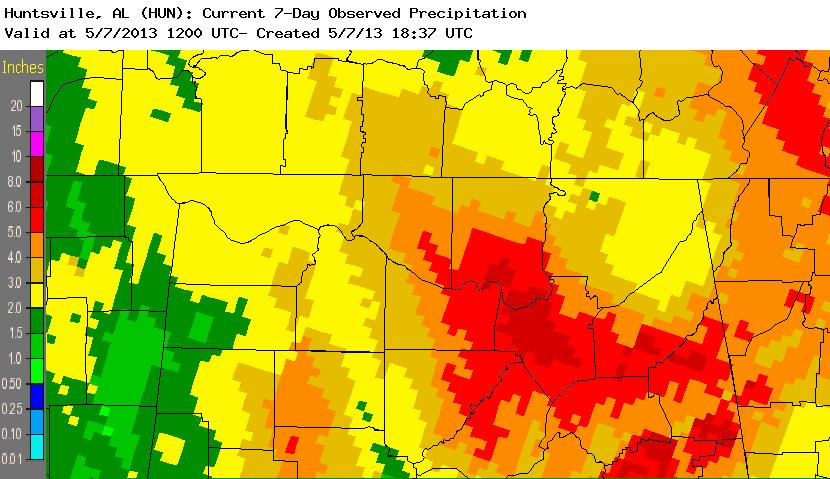
Starting on Friday, May 3rd, a slow moving cold upper level low for early May brought the Tennessee Valley an extended period of heavy rain and cooler temperatures. A good portion of this fell late Friday afternoon into Saturday morning, after it's associated cold front pushed through the area. Then a brief break in the steady rain occured until the upper low dropped across north Alabama on Sunday into Monday. This produced additional areas of steady rainfall that added another 1 to 3 inches of rainfall on top of what had already fallen, especially across northeast Alabama. Although the rainfall was not extremely intense, the slow movement of the upper level low contributed to the high rainfall totals. This lead to impressive amount totals between 6 and 8 inches in southern Madison, central Marshall, and southwestern Dekalb counties for the entire event. Below is an image of rainfall totals from 7 am on May 1st through May 7th. All of this rainfall fell between May 3rd and May 6th.
|
||||||||||||
Rainfall Increased Precip Surpluses for 2013
|


 Local Radar
 Weather Map