
Heat expands across the Desert Southwest, Plains, Mississippi Valley and Midwest into Monday. Fire weather concerns continue for portions of the Intermountain West. Active monsoonal moisture fuels thunderstorms over the Southwest with possible flash flooding. Tropical cyclone Fausto in the Pacific, should weaken as it approaches Hawaii; Dangerous surf, swells and rip currents are expected. Read More >
|
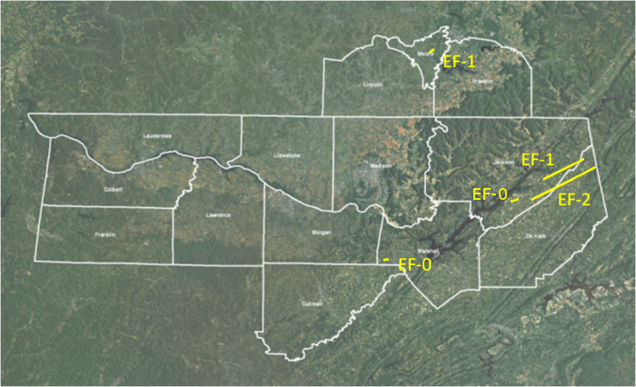
During the late evening hours of October 24th and early morning of October 25th, 2010, severe thunderstorms moved across northern Alabama, and southern middle Tennessee. The first wave of thunderstorms occurred between 10:00 PM and 1:00 AM CDT. These thunderstorms produced quarter to golfball sized hail and damaging winds across the area and one tornado touchdown in Moore County, Tennessee. A second wave of thunderstorms moved from northern Mississippi over north Alabama and southen Middle Tennessee between 1:00 AM and 5:00 AM CDT on Monday, October 25th. This line of storms produced four tornadoes. One occurred over far southwest Marshall County, Alabama around 3:20 am CDT near the Arab community. Three more tornadoes tracked simultaneously across southeastern Jackson and northern Dekalb Counties along a line of thunderstorms around 3:50 to 4:30 am CDT. |
| Confirmed Tornado Paths |
|
Click on the storm track in the map below to see detailed information pertaining to each storm. |
Click here to see a list of storm reports from this severe weather event.
|
 |
 |
 |
 |


 Local Radar
 Weather Map