National Weather Service United States Department of Commerce

Cold Front Moving Through the Northeast U.S. Monday; Atmospheric River to Impact the Pacific Northwest Midweek

A cold front will cross the Great Lakes and Northeast U.S. through Monday with gusty winds and areas of rain showers. A strong atmospheric river is expected to move into the Pacific Northwest by midweek bringing a threat for moderate to heavy rainfall, gusty winds, and mountain snows for parts of Washington, Oregon, northern California, and the Sierra Nevada. Read More >

NWS Huntsville Warning and Forecast Area
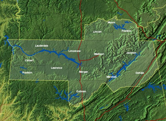
Map of the NWS Huntsville, AL County Warning and Forecast Area
This is the area that we issue forecasts and warnings for. It includes 11 counties in northern Alabama: Colbert, Cullman, DeKalb, Franklin, Jackson, Lawrence, Lauderdale, Limestone, Madison, Marshall, and Morgan; and 3 counties in southern middle Tennessee: Franklin, Lincoln, and Moore.


NWS Huntsville History


Station History (Narrative) - Follow the evolution of the presence of the National Weather Service and U.S. Weather Bureau in Huntsville. Click here for a detailed history of management positions at the WFO Huntsville office.

 
Timeline of Station History/Major Weather Events - Follow the evolution of the presence of the National Weather Service and U.S. Weather Bureau in Huntsville and some major weather events which occurred in the NWS Huntsville area .  
 

Follow the Construction of the NWS Huntsville Forecast Office - Below are pictures of the office as it was built, from Spring 2002 through January 14, 2003.

April 9, 2002 August 22, 2002 September 5, 2002 October 31, 2002
January 13, 2003      
 
Other Links of Interest
 
WFO/WSO Huntsville Awards - National Weather Service Huntsville staff have received multiple office and individual national and regional awards for service to the public.
 
Local Research - The meteorologists at your National Weather Service perform extensive research on past significant weather events and integrating new science and technology into our forecasts and warnings.