
Record setting heat is expected over the next several days from the Intermountain West through the northern Plains. Furthermore, fire weather concerns increase with dry and breezy conditions. Meanwhile, heavy rainfall and severe thunderstorm threats for the Ohio/Tennessee Valleys, central Appalachians and Southeast today. The threat shifts to central Gulf Coast and across central Texas this week. Read More >
SURFACE | UPPER AIR | CAMERAS | WINTER DATA | ROAD CONDITIONS
| Latest Station Observations |
| Eastern Utah and Western Colorado | |||
| E Utah / SW Colorado | Far W Colorado | N Mtns / Continental Divide | |
| Vernal, UT | Craig, CO | Hayden, CO | |
| Price, UT | Meeker, CO | Walton Peak, CO | |
| Canyonlands Airport, UT | Rifle, CO | Steamboat Springs, CO | |
| Grand Junction, CO | Eagle, CO | ||
| Blanding, UT | Delta, CO | Aspen, CO | |
| Cortez, CO | Montrose, CO | Leadville, CO | |
| Nucla, CO | Telluride, CO | Gunnison, CO | |
| Durango, CO | Wolf Creek Pass, CO | ||
| Pagosa Springs, CO | |||
| Rangely, CO | |||
| Other Utah Cities | Other Colorado Cities | Other States | |
| Observations from Mesowest | Observation Handbook | ||
| Statewide Hourly Observations | |||
| Colorado | Utah | Arizona | |
| New Mexico | Wyoming | ||
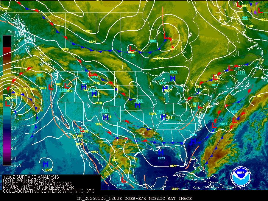
| Surface Analysis |
|
||||||||||||||
|
| Text Products | |||
| Public Information Statements | Record Event Reports | Local Storm Reports | |
| Additional Information | |||
| Observation Handbook - FMH-1 | Wind Chill Calculations | Heat Index Calculations | |
| Terms | |||
| NWS Acronyms | Interpreting Weather Maps and Observations | ||


