On March 13, 1990, an early season outbreak of tornadoes ripped across the interior United States. A total of 59 tornado touchdowns impacted the states of Iowa, Kansas, Missouri, Nebraska, Oklahoma and Texas. Of the 59 tornadoes, 44 of the tornadoes occurred in Nebraska and Kansas. The more well known tornadoes include the Hesston, KS F5 tornado, and the Lawrence, NE F4 tornado.
A description of the Fujita Scale ranking can be found here.
This summary focuses on the tornadoes across south central Nebraska and north central Kansas. The Lawrence, Nebraska tornadic complex tracked northeast for 124 miles!
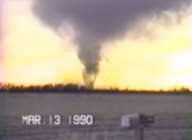
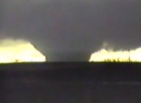
Tornado Video Screen Captures From March 13, 1990
 |
 |
 |
|
Courtesy of Kris Stoltenburg
Location is the corner of Abbott and Engelman road northwest of Grand Island, looking southwest. The tornado passed 3/4 mile west of her location.
|
Courtesy of Robert Schroeder
Location is 5.5 miles southwest of Lawrence, looking southwest. The tornado passed 1/2 mile east of the Schroeder residence.
|
Courtesy of Harold Rehtus
Mr. Rehtus lived in eastern Webster county at the time of the tornado.
|
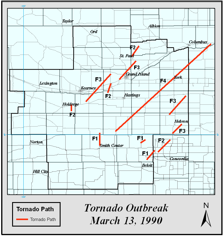
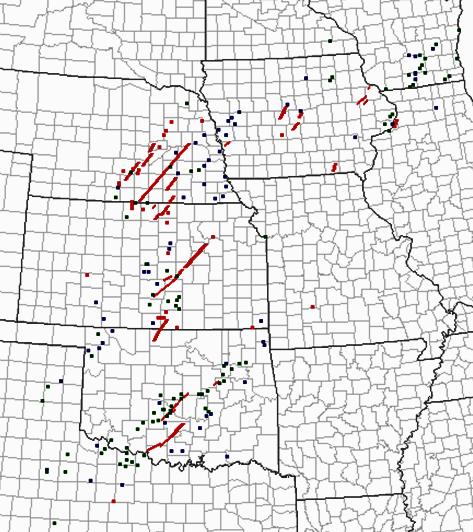
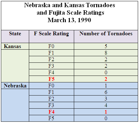
The maps below depict the location of the tornadoes across south central Nebraska and north central Kansas, and across the Plains region. The table shows the strength (ratings) of the tornadoes. As widespread as the outbreak of tornadoes was on the 13th, experiencing tornadoes in March is typically not a common occurrence. Historically speaking, in Nebraska, 68 tornadoes have been reported in March since 1950. Tornadoes have been reported during March in just 12 different years since 1950. The majority of those 57 tornadoes occurred in just three years: 16 tornadoes occurred in 2007, 15 in 1990, and 8 in 2009. Based on the data, since 1950, the average number of tornadoes in March is about 2.
Since 1880, only one other March tornado event seems to compare in intensity to March 13, 1990: The "Easter Sunday" tornado outbreak on March 23, 1913. Several tornadoes devastated the Omaha area on that fateful day. 103 people were killed, including 94 in Omaha. At least 600 homes were destroyed in Omaha and another 1,100 damaged. There were no less than four F4 tornadoes reported.
Tornado Path and Intensity Information
 |
 |
 |
| Map of the paths of the multiple tornadoes. The associated Fujita (F-scale) rating is depicted with the tornado tracks. Note: this map does not include all of the F1 tornadoes or the brief F0 tornado. |
Map of severe weather reports across the Plains and Midwest. Tornados and paths are indicated by red. Hail reports are in black. |
Table depiction depicting the number of tornadoes across Kansas and Nebraska on March 13, 1990. Many of the tornados were strong (F2 or F3) or violent (F4 or F5). |
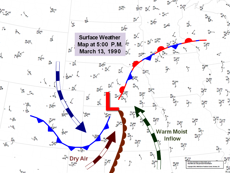
Meteorologically, several ingredients need to come together to for weather conditions to be conducive for tornado development. On March 13, 1990, a strong surface low pressure was located in north central Kansas. The low pulled unseasonably warm and most air north into the south central Nebraska and north central Kansas. Surface dewpoint temperatures rose to above 60 degrees in eastern Nebraska while surface temperatures topped 70 degrees in northern Kansas. A surface dryline, or push of dry air from the west southwest, bulged into north central Kansas, and was part of the spark to ignite the explosive instability in place. Typical of strong March weather systems, while central and eastern Nebraska and Kansas were impacted by severe weather, the Nebraska panhandle experienced heavy snow, ice and wintry weather conditions. Some areas of the Nebraska panhandle measured up to 8 inches of snow. Blizzard-like conditions were reported.
Late Afternoon Surface Map
(click to enlarge)
Now, let's look back at the facts and impacts of the tornadoes, by ranking, on March 13, 1990:
The F4:
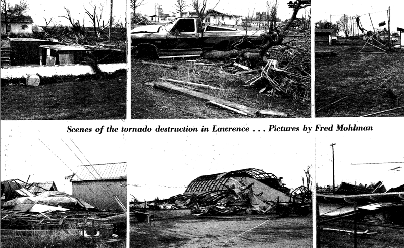
Highlights of the "Lawrence Tornado":
- 124 mile path from 3 miles south of Red Cloud to 3 miles east of Schuyler.
- Total of 9 injuries. No fatalities occurred.
- Rated an F4 on the original Fujita Scale. Winds estimated between 207 mph and 260 mph.
- Estimated width of 1200 feet, or about 1/4 mile.
- In Webster County, 7 farms damaged. One farm was "wiped out".
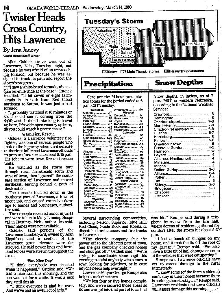
- In Nuckolls County, 53 homes damaged in Lawrence, included eight which were destroyed. Eight more farmsteads were hit in rural areas.
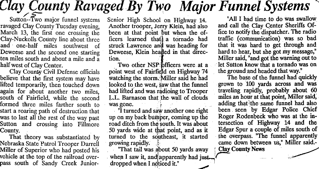
- In Clay County, one business was destroyed, 11 were damaged, 20 farms were hit and 49 homes were damaged in Sutton.
- In Fillmore County, power lines and trees were damaged in the extreme northwest corner of the county.
- In York County, about a dozen farms were hit. One farm house 4 miles west of McCool Junction was destroyed. Near Waco, 57 train cars were derailed. The roof was torn from a motel at the Interstate 80 interchange south of York. An estimated 10,000 geese were killed by the storm.
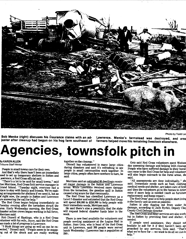
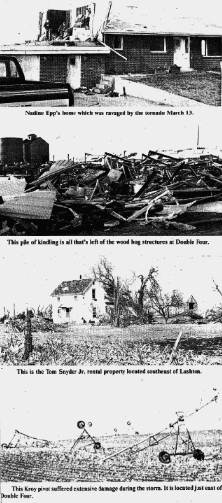
The articles below are just snippets of the numerous ones written about the tornadoes, damage and impacts. Click on the images to enlarge.
Local Newspaper Articles
 |
 |
 |
 |
| Hastings, Tribune |
Lawrence Locomotive |
Henderson News |
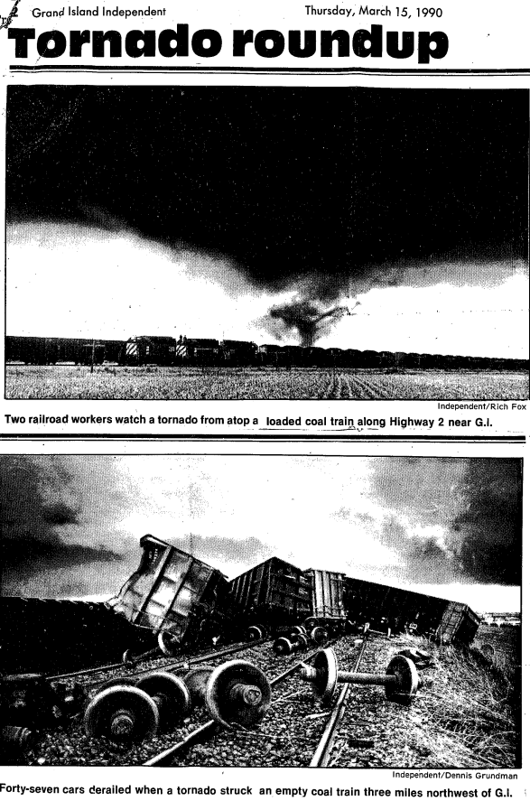
Grand Island Independent |
The F3's:
Highlights from the tornado northwest of Grand Island:
- 25 mile path from 1 mile north of Alda to 3 miles southeast of Palmer.
- No injuries or fatalities.
- Rated an F3 on the original Fujita Scale. Winds estimated between 158 mph and 206 mph.
- Estimated with of 600 feet.
- In Hall County, 15 railroad cars were overturned at the old Army Ordinance Plant west of Grand Island. 47 rail cars were toppled on the Burlington Northern line northwest of Grand Island. One mobile home was demolished 5 miles northwest of Grand Island and several farms sustained damage.
- In Howard and Merrick Counties, one mobile home was destroyed southeast of St. Libory. Extensive damage, with loss of cattle, occurred on four farms southeast of Palmer.
Highlights from the Minden/Lowell tornado:
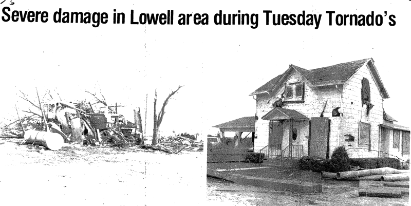
- 36 mile path from 3 miles northwest of Minden, to 2 miles south of Cairo (passing 1 mile east of Lowell, 7 miles southwest of Shelton, and 6 miles west southwest of Wood River to 2 miles south of Cairo).
- No injuries or fatalities.
- Rated an F3 on the original Fujita Scale. Winds estimated between 158 mph and 206 mph.
- Numerous outbuildings were destroyed, trees uprooted, power lines downed, and a county bridge was destroyed.
- Four farmsteads were heavily damaged southeast of Lowell, and a farm southwest of Shelton had extensive damage.
Highlights from the Carleton/Exeter tornado:
- 0.6 mile path from 1 mile north of Carleton to 6 miles southeast of Shickley, then lifted 3 miles southeast of Exeter.
- No injuries or fatalities.
- Rated F3 on the original Fujita Scale. Winds estimated between 158 mph and 206 mph.
- Damage to a farm north of Carleton. Windows were broken and trees uprooted.
- On the northeast edge of Strang, a mobile home was destroyed and a metal roof was pulled off of a building.
- On another farm northeast of Strang, a large hog facility and outbuildings were destroyed, and downed trees blocked the highway. Power lines were damaged.
Highlights from the Chester/Hebron tornado:
- 13 mile path from Chester to 5 miles east of Hebron.
- No injuries or fatalities.
- Rated F3 on the original Fujita Scale. Winds estimated between 158 mph and 206 mph.
- Trees, outbuildings, and propane tanks were damaged on the outskirts of Chester.
- Two miles northeast of Chester, a farm home was damaged, a machine shed was destroyed, and there was extensive damage to a combine, tractor and truck.
- A number of farmsteads were damaged southeast of Hebron. Trees were uprooted, power lines downed, and fences damaged along the path.
Local Newspaper Articles
 |
 |
 |
| Nance County Journal |
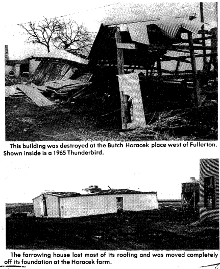
York News Times |
Omaha World Herald |
The F2's:
Highlights from the Belgrade tornado:
- 13 mile path from 2 miles northwest of Palmer to 5 miles southwest of Belgrade.
- No injuries of fatalities.
- Rated an F2 on the original Fujita Scale. Winds estimated between 113 mph and 157 mph.
- The tornado damaged 10 farms in Nance County, including four farm homes. Trees were uprooted, power lines downed, and outbuildings were damaged.
Highlights from the Wilcox tornado:
- 8 mile path from 1 mile south of Wilcox to 7 miles north of Wilcox.
- No injuries or fatalities.
- Rated an F2 on the original Fujita Scale. Winds estimated between 113 mph and 157 mph.
- Extensive damage occurred to farms south and north of Wilcox, where livestock were killed.
- Outbuildings, and center pivots were destroyed and trees were downed.
Highlights from the Prosser/Wood River tornado:
- 9 mile path from 4 miles west of Prosser to Wood River.
- No injuries of fatalities.
- Rated an F2 on the original Fujita Scale. Winds estimated between 113 mph and 157 mph.
- Two farms were hit causing extensive damage to a farmhouse. Outbuildings, grain bins, two barns and many trees were damaged or destroyed.
Local Newspaper Articles
 |
 |
 |
| Gibbon Reporter |
The Red Cloud Chief |
Hebron Journal - Register |
Additional tornadoes (F1 and F0):
Several F1 tornadoes and an F0 tornado also touched down on the 13th. An F1 had a 13 mile track from 2 miles north of Smith Center, KS, and lifted just two miles south of the Nebraska border (6 miles east of Thornburg, KS). An F1 tracked for 1.5 miles about 1.5 miles northeast of Esbon, KS. At Lovewell Lake, a tornado began 2 miles south of the lake, and moved north northeast across the lake, lifting near Webber. Several large trees were ripped from the ground and several boats and small buildings were destroyed. An F1 tornado began 2 miles northwest of Shelton and moved northeast for one mile, causing minor damage. An F1 tornado started 2 miles southeast of Fullerton and moved northeast to three miles east of town before lifting. Trees were uprooted and power lines destroyed. Finally, an F0 tornado occurred briefly in an open field two miles north of Kearney.
|

|
This page was composed by the staff at the National Weather Service in Hastings, Nebraska. |
 |


