El Niño/Southern Oscillation
The phenomenon of El Niño has been observed for centuries. Fishermen off the coast of Peru noted that unusually warm waters would occasionally reduce the number of otherwise abundant anchovies and other fish. Because the effects often began near Christmastime, the phenomenon was dubbed "El Niño", Spanish for the child, or more specifically, the Christ child. It was known that the phenomenon occurred every few years at irregular intervals; however, the far-reaching effects were not discovered until the 20th century.
After weather data became available in the South Pacific during the 19th century, a negative correlation between the pressure at Papeete (Tahiti, French Polynesia) and Darwin (Northern Territory, Australia) was noted. With striking consistency, abnormally high pressure and drought in Australia would coincide with low pressure and increased precipitation over the Polynesian islands of the central Pacific. This is known as the Southern Oscillation. The Southern Oscillation Index (SOI) is based on the pressure data from Tahiti and Darwin, which is available back to 1866.
In 1923, Sir Gilbert Thomas Walker first described the large-scale circulation which accounted for the Southern Oscillation. The circulation, which bears his name, notes both the horizontal (zonal) and vertical movement of air in the equatorial Pacific.

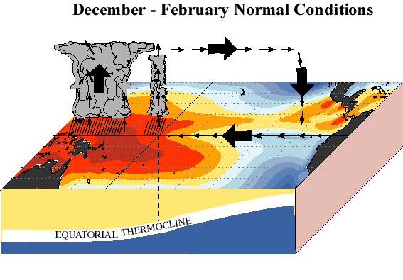
The typical Walker Circulation is shown above. Low surface pressure and precipitation in the western Pacific is an area of large-scale ascent while high surface pressure and limited precipitation in the eastern Pacific is an area of large-scale descent. Easterly trade winds at the surface blow from east to west in the equatorial Pacific. The westerly jet aloft was later verified with weather balloons and other data.
Guided by the winds, a westward ocean current moves water from the eastern Pacific into the central Pacific. As water is evacuated from the eastern Pacific, cool subsurface water replaces it along the coast of South America. This process, called upwelling, results in the typically cool waters of the eastern Pacific.
Away from the equator, this westward current diverges. Due to the Coriolis force, the water turns north in the northern hemisphere and south in the southern hemisphere. The result is an evacuation of the surface water along the equator. While both the warm water of the western Pacific and the cool water of the eastern Pacific would have a tendency to fill this void, the gravitational pull east of the warm water is balanced by the consistent easterly trade winds. As a result, the cool water typically reaches the central Pacific.
As it would appear, these trade winds are absolutely necessary for maintaining this system. When the trade winds weaken, the mass of water they hold up in the western Pacific begins to pour eastward along the equator. Often in concert, the lessened winds in the eastern Pacific diminish the typical upwelling process. As a result, the water along the coast of South America warms. This is the El Niño effect that fishermen noted centuries ago.
During an El Niño event, the Walker Circulation is greatly diminished. Increased precipitation and abnormally warm water are found in the central Pacific during an El Niño event (or ENSO warm phase). These changes in weather patterns have a cascading effect on weather patterns in other parts of the world. In addition, the Pacific Ocean is a massive heat source. Changing the distribution and magnitude of heat the ocean imparts to the atmosphere has significant consequences well beyond the tropical Pacific.
If the trade winds are stronger than normal, cool water may reach into the western Pacific. In such an event, the Walker Circulation is stronger than normal. Where El Niño describes events with a weaker than normal circulation, a stronger circulation is in many ways its opposite. The female child, or "La Niña", was coined to describe the ENSO cold phase.
Oddly enough, many of the global impacts of La Niña are opposite of those wrought by El Niño. For example, an area that experiences increased precipitation during El Niño may see a similar decrease in precipitation during La Niña. This is true for much of the Gulf Coast during the cold season.
For more general information about ENSO, visit the links below.
ENSO Summaries
![]() Climate Prediction Center (CPC)
Climate Prediction Center (CPC)
![]() Physical Sciences Laboratory (PSL)
Physical Sciences Laboratory (PSL)
![]() International Research Institute for Climate and Society (IRI)
International Research Institute for Climate and Society (IRI)
Educational Materials
![]() ENSO Webcast (from COMET) free registration required
ENSO Webcast (from COMET) free registration required