Sioux Falls, SD
Weather Forecast Office
Click Image To Enlarge
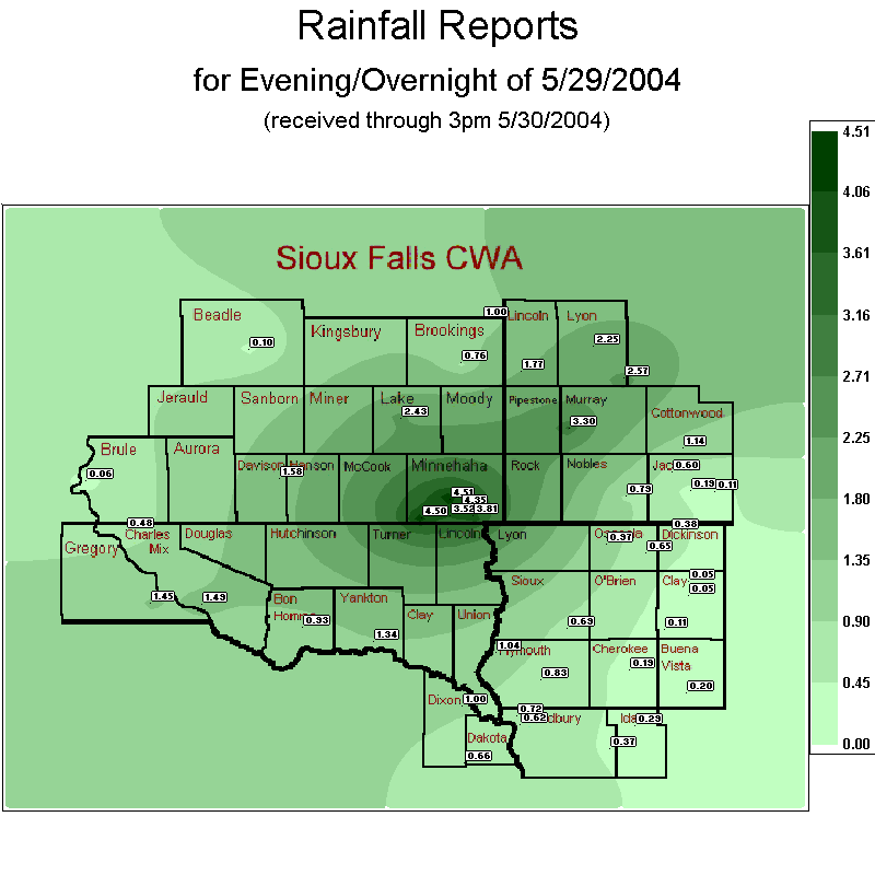
Rainfall Reports for the Evening and Overnight of May 29, 2004.
South Dakota:
Huron                 0.10
  Chamberlain           0.06
  Academy               0.48
  Bonesteel             1.45
  Pickstown             1.49
  Mitchell              1.58
  Tyndall               0.93
  Yankton               1.34
  Madison               2.43
  Crooks                4.51
  Sioux Falls AP        4.35
  Brookings             0.76
  Astoria               1.00
  SW Sioux Falls        3.52
  SE Sioux Falls        3.81
  Wall Lake             4.50
Minnesota:
Lake Benton           1.77
  Marshall              2.25
  Tracy                 2.57
  Lake Wilson           3.30
  Windom                1.14
  Heron Lake            0.60
  Lakefield             0.19
  Jackson               0.11
  Worthington           0.79
Iowa:
Sioux City AP         0.62
  Akron                 1.04
  Alton                 0.69
  Sioux City Perry Crk  0.72
  Holly Springs         0.37
  Merrill               0.83
  Holstein              0.29
  Storm Lake            0.20
  Cherokee              0.19
  Peterson              0.11
  Spencer               0.05
  Everly                0.05
  May City              0.65
  Lake Park             0.38
  Sibley                0.97
Nebraska:
Ponca                 1.00
  Emerson               0.66
Popular Pages
Past Weather Events
Regional Weather Roundup
Daily Temp/Precip
Hazardous Weather
Local Climate Archives
Climate Graphs and Data
Seasonal
EvapoTranspiration
Fire Weather
Grassland Fire Danger
Flooding (River)
Summer Weather
Travel Forecasts
Winter Weather
Winter Preparedness
Forecast Snowfall Graphic
Winter Temp Climatology
US Dept of Commerce
National Oceanic and Atmospheric Administration
National Weather Service
Sioux Falls, SD
26 Weather Lane
Sioux Falls, SD 57104-0198
605-330-4247
Comments? Questions? Please Contact Us.


 Weather Story
 Weather Map
 Local Radar