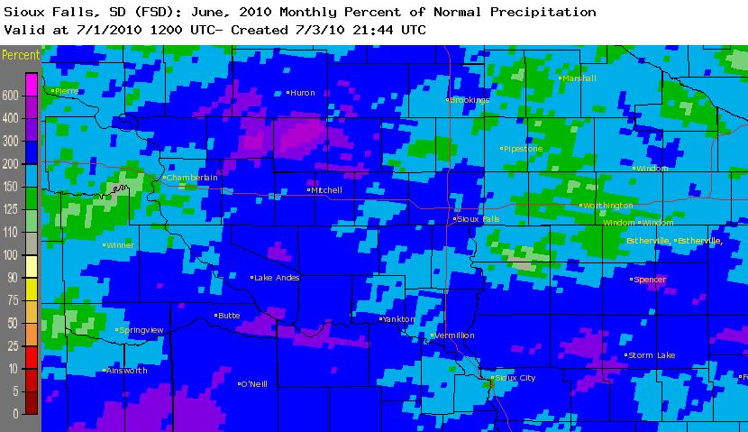
Despite temperatures across the Tri-State region averaging near normal in June (+/- 1.5 degree F), the area did see some extreme weather in regards to rainfall amounts. Most of the region came in with June rainfall totals ranking in the top 10 on record. Based on the preliminary data coming in, a handful of sites set new record June rainfall totals, including Wessington Springs, SD with 10.43", Spencer, IA with 12.81", Sanborn, IA with 9.91", Cherokee, IA with 13.11", and Primghar, IA with 12.35". From the image below, you can see that the entrie region saw June rainfall totals running between 150% and 300% of normal, with a few areas coming in at over 400% of normal.
Many other areas in the United States also saw some extreme weather in June. Here are some of the June Highlights from the National Climatic Data Center:
- The Southeast, South and Central regions experienced their second, fifth and seventh warmest June on record, respectively. Only the Northwest averaged a temperature below normal for June.
- Record-warm June temperatures occurred in Delaware, New Jersey and North Carolina; each had average temperatures between 5 and 6 degrees F above the long-term mean. Seventeen other states had temperatures that ranked among their 10 warmest for June. Only Oregon and Washington had below normal average temperatures for June.
- Michigan had its wettest June on record, followed by: Iowa (2nd wettest), Nebraska and Illinois (3rd), Indiana (4th), Wisconsin (5th), Oregon (6th), and Ohio (10th). Maryland and Virginia experienced below average precipitation for June.
- Alex, the first June hurricane in the Atlantic since 1995, made landfall just south of the U.S.-Mexico border on June 30th, affecting portions of South Texas. Alex’s sustained winds of 105 mph made it June’s most intense Atlantic hurricane since Alma in 1966.
- NOAA’s Storm Prediction Center tabulated 387 preliminary tornado reports during June. If confirmed, this will be the second most active June on record, behind 1992.


 Weather Story
 Weather Map
 Local Radar