A cold front moved through the eastern half of South Dakota during the evening and overnight hours of May 29th, fueling a line of thunderstorms which developed around 7 PM CDT and propagated eastward thereafter. Hail up to baseball size and rainfall over 2.5 inches was reported in portions of south central South Dakota in association with these storms. The following is a summary of severe weather reported on May 29th and 24 hour rainfall totals through the morning of May 30th.
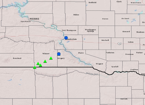
Green triangles = hail reports, blue dots = severe wind gusts
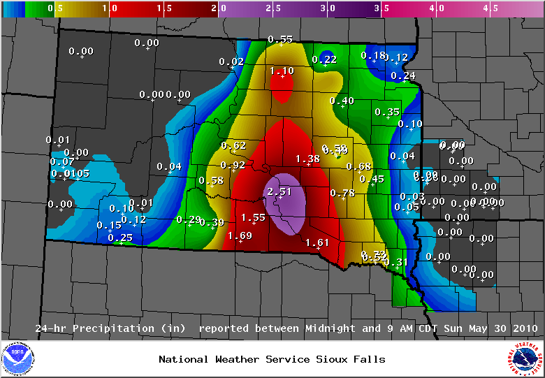
.SEVERE WEATHER REPORTS...

LOCATION            REPORT
------------        ------------
2 E KEYAPAHA        1.25 INCH HAIL
7 E CLEARFIELD      1.50 INCH HAIL
8 SSW KEYAPAHA      1.75 INCH HAIL
COLOME              2.75 INCH HAIL
3 WSW MILLBORO      2.00 INCH HAIL
1 SW DIXON          1.50 INCH HAIL
3 NNW DIXON         1.00 INCH HAIL
1 SW DIXON          60 MPH WIND GUST
3 NE CHAMBERLAIN    60 MPH WIND GUST


.24 HOUR RAINFALL TOTALS...

LOCATION            REPORT
------------        ------------
CHAMBERLAIN         2.51 INCHES
PICKSTOWN           1.61 INCHES
WINNER              1.55 INCHES
WAGNER              1.25 INCHES
6 NE TYNDALL        1.20 INCHES
SENECA              1.15 INCHES
ROSCOE              1.10 INCHES
MITCHELL            0.78 INCHES
YANKTON             0.73 INCHES
ABERDEEN            0.66 INCHES
PIERRE              0.62 INCHES
HURON               0.58 INCHES
MURDO               0.58 INCHES
MADISON             0.46 INCHES
WINFRED             0.45 INCHES
8 NE COLUMBIA       0.44 INCHES
TURTON              0.40 INCHES
VERMILLION          0.39 INCHES
WALL LAKE           0.37 INCHES
WATERTOWN           0.35 INCHES
9 NW BRITTON        0.30 INCHES
PINE RIDGE          0.25 INCHES
WILMONT             0.24 INCHES
SIOUX FALLS         0.23 INCHES
EROS DATA CENTER    0.22 INCHES
ROY LAKE            0.18 INCHES
SISSETON            0.12 INCHES
CLEAR LAKE          0.10 INCHES
BROOKINGS           0.04 INCHES
PHILIP              0.04 INCHES
MOBRIDGE            0.02 INCHES

$$


 Weather Story
 Weather Map
 Local Radar