Sioux Falls, SD
Weather Forecast Office
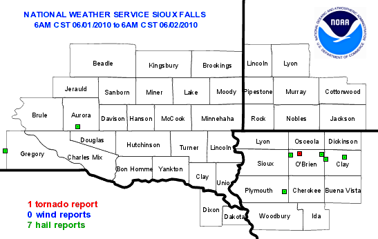
SPC Storm Report Page for 100601
Tornado Reports
| Time (UTC) | Location | County | State | Lat | Lon | Comments |
| 1822 | 4 WNW SANBORN | O'BRIEN | IA | 43.2 | -95.73 | BRIEF TOUCHDOWN (FSD) |
Hail Reports
| Time (UTC) | Size (inches) | Location | County | State | Lat | Lon | Comments |
| 1330 | 1.00 | 1 SW DALLAS | GREGORY | SD | 43.23 | -99.53 | MOSTLY NICKEL AND DIME SIZE. VERY HEAVY RAIN. (FSD) |
| 1407 | 1.00 | 8 NNW HARRISON | AURORA | SD | 43.55 | -98.59 | VERY HEAVY RAIN. (FSD) |
| 1822 | 1.00 | SHELDON | O'BRIEN | IA | 43.18 | -95.84 | VERY HEAVY RAIN. (FSD) |
| 1848 | 1.75 | MONETA | CLAY | IA | 43.13 | -95.39 | (FSD) |
| 1851 | 2.50 | 2 ENE HARTLEY | O'BRIEN | IA | 43.19 | -95.44 | DAMAGE TO TREES AND CARS (FSD) |
| 1910 | 1.00 | SPENCER | CLAY | IA | 43.15 | -95.15 | (FSD) |
| 1951 | 1.75 | 8 SSE REMSEN | PLYMOUTH | IA | 42.71 | -95.92 | (FSD) |
Wind Reports
| Time (UTC) | Speed (mph) | Location | County | State | Lat | Lon | Comments |
| No Reports | |||||||
Popular Pages
Past Weather Events
Regional Weather Roundup
Daily Temp/Precip
Hazardous Weather
Local Climate Archives
Climate Graphs and Data
Seasonal
EvapoTranspiration
Fire Weather
Grassland Fire Danger
Flooding (River)
Summer Weather
Travel Forecasts
Winter Weather
Winter Preparedness
Forecast Snowfall Graphic
Winter Temp Climatology
US Dept of Commerce
National Oceanic and Atmospheric Administration
National Weather Service
Sioux Falls, SD
26 Weather Lane
Sioux Falls, SD 57104-0198
605-330-4247
Comments? Questions? Please Contact Us.


 Weather Story
 Weather Map
 Local Radar