Sioux Falls, SD
Weather Forecast Office
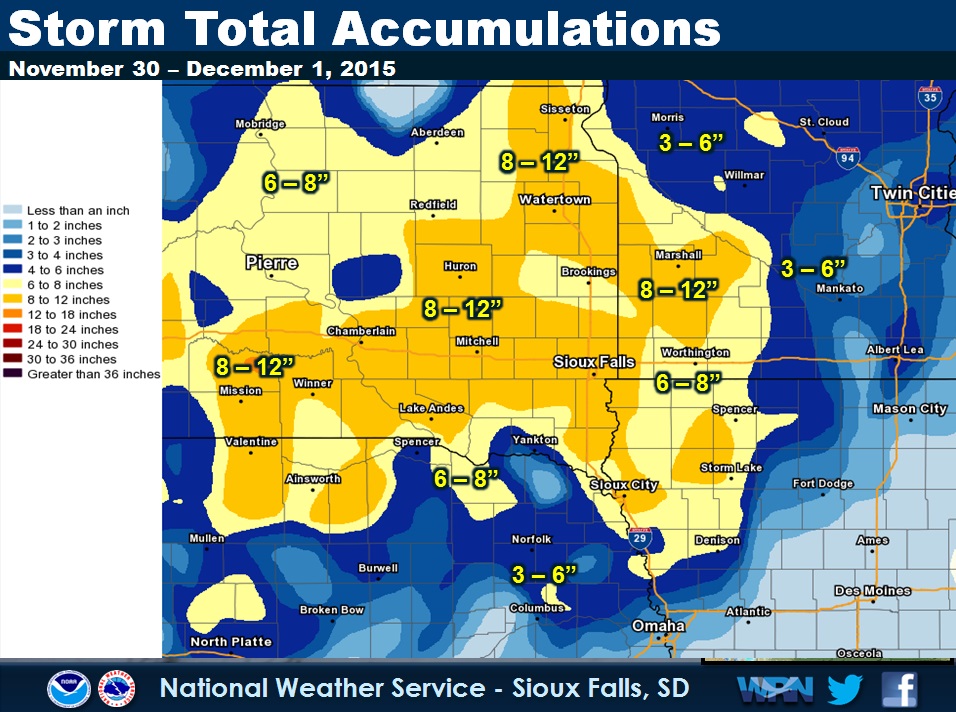
A large and slow moving winter storm moved across the region to end the month of November and welcome in the month of December. Light freezing drizzle developed late during the night of November 29th with heavy snow rapidly developing during the morning hours of November 30th. By the afternoon and evening hours of the 30th, many areas already had received upwards of 4 to 8 inches of snow. Additional snow fell through the night and through December 1st, as this large storm system struggled to move east of the region.
This storm system also set several daily snowfall records for the local area including:
November 30, 2015 – 8.7” of new snow in Sioux Falls
November 30, 2015 – 6.6” of new snow in Sioux City
Total accumulations ranged from 6 to 12" across the area, on top of a very light glaze of ice in southeastern South Dakota, southwestern Minnesota, northwest Iowa, and northeast Nebraska.
 |
 |
Popular Pages
Past Weather Events
Regional Weather Roundup
Daily Temp/Precip
Hazardous Weather
Local Climate Archives
Climate Graphs and Data
Seasonal
EvapoTranspiration
Fire Weather
Grassland Fire Danger
Flooding (River)
Summer Weather
Travel Forecasts
Winter Weather
Winter Preparedness
Forecast Snowfall Graphic
Winter Temp Climatology
US Dept of Commerce
National Oceanic and Atmospheric Administration
National Weather Service
Sioux Falls, SD
26 Weather Lane
Sioux Falls, SD 57104-0198
605-330-4247
Comments? Questions? Please Contact Us.


 Weather Story
 Weather Map
 Local Radar