Overview
|
A powerful early spring storm brought a variety of weather to the area the weekend of March 14-15, 2026. The early morning of March 14th saw a band of light snow lift north, but the main impacts were felt from Saturday evening through Sunday night. |
|
Wind

...HIGHEST WIND REPORTS DURING MARCH 14-15 2026 BLIZZARD...

Location                     Speed     Time/Date       Provider

...Iowa...

...Buena Vista County...
Storm Lake Airport           58 MPH    0415 PM 03/15   AWOS
Storm Lake                   53 MPH    0720 PM 03/15   MESOWEST

...Cherokee County...
Cherokee Municipal Airport   49 MPH    0705 PM 03/15   AWOS

...Clay County...
Spencer Municipal Airport    60 MPH    0725 PM 03/15   ASOS
Spencer                      45 MPH    1030 PM 03/15   MESOWEST

...Dickinson County...
Lake Park                    48 MPH    1100 PM 03/15   CWOP
Spirit Lake                  44 MPH    0911 PM 03/15   CWOP

...Ida County...
Battle Creek                 55 MPH    0705 PM 03/15   DAVIS

...Lyon County...
Larchwood                    38 MPH    0655 PM 03/15   DAVIS

...OBrien County...
Sheldon Airport              53 MPH    0715 PM 03/15   AWOS

...Plymouth County...
Le Mars Airport              49 MPH    0535 PM 03/15   AWOS
Sioux City                   45 MPH    1115 PM 03/15   DAVIS
Remsen                       38 MPH    0545 PM 03/15   DAVIS

...Sioux County...
1 NE Maurice                 56 MPH    0215 PM 03/15   AWOS
Hawarden                     49 MPH    0540 PM 03/15   CWOP

...Woodbury County...
Sioux Gateway Airport        59 MPH    0613 PM 03/15   ASOS
Moville                      48 MPH    0545 PM 03/15   MESOWEST
Sioux City                   47 MPH    0605 PM 03/15   MESOWEST

...Minnesota...

...Cottonwood County...
T.h.60 - Mountain Lake - Mp  60 MPH    0715 PM 03/15   MESOWEST
Windom Municipal Airport     56 MPH    0815 PM 03/15   AWOS
T.h.71 - Jeffers - Mp 43     55 MPH    0645 PM 03/15   MESOWEST

...Jackson County...
I-90 - Lakefield - Mp 67     57 MPH    0730 PM 03/15   MESOWEST
Jackson Airport              56 MPH    0815 PM 03/15   AWOS
Lakefield                    49 MPH    0648 PM 03/15   CWOP

...Lincoln County...
U.s.14 - Lake Benton - Mp 7  53 MPH    0815 PM 03/15   MESOWEST
T.h.19 - Hendricks - Mp 2    51 MPH    0615 PM 03/15   MESOWEST

...Lyon County...
U.s.14 - Florence - Mp 21.2  64 MPH    0620 PM 03/15   MESOWEST
Marshall Municipal Airport   53 MPH    0622 PM 03/15   AWOS
T.h.68 - Taunton - Mp 22.9   52 MPH    0725 PM 03/15   MESOWEST
Tracy Airport                49 MPH    0515 PM 03/15   AWOS
Marshall                     40 MPH    1008 PM 03/15   CWOP

...Murray County...
T.h.30 - Dovray - Mp 49      53 MPH    0800 PM 03/15   MESOWEST
Slayton Municipal Airport    45 MPH    0733 PM 03/15   AWOS

...Nobles County...
I-90 - Rushmore - Mp 35      56 MPH    0510 PM 03/15   MESOWEST
Worthington Airport          56 MPH    0701 PM 03/15   AWOS
Reading                      40 MPH    0735 PM 03/15   DAVIS
Reading                      38 MPH    0135 PM 03/15   DAVIS

...Pipestone County...
U.s.75 - Trosky - Mp 30.3    60 MPH    0710 PM 03/15   MESOWEST
Redstone RAWS                46 MPH    0621 PM 03/15   RAWS

...Rock County...
I-90 - Beaver Creek Mp 4     58 MPH    0510 PM 03/15   MESOWEST
I-90 - Magnolia - Mp 21.6    54 MPH    0820 PM 03/15   MESOWEST
Luverne Airport              45 MPH    0615 PM 03/15   AWOS
Luverne                      43 MPH    0545 PM 03/15   CWOP

...Nebraska...

...Dakota County...
D3-Rwis 35 48.65             50 MPH    0607 PM 03/15   MESOWEST
South Sioux City             45 MPH    1000 PM 03/15   CWOP

...Dixon County...
Concord 2E                   50 MPH    0615 PM 03/15   NE-MESO

...South Dakota...

...Aurora County...
White Lake (SD Mesonet)      44 MPH    0420 PM 03/15   SDSMESO

...Beadle County...
SD RWIS WOLSEY               44 MPH    0423 PM 03/15   SDDOT

...Bon Homme County...
SD RWIS Tyndall              54 MPH    0209 PM 03/15   SDDOT
Avon 3E (SD Mesonet)         50 MPH    1155 AM 03/15   SDSMESO
Scotland                     41 MPH    0245 PM 03/15   DAVIS

...Brookings County...
Brookings Municipal Airport  46 MPH    0339 PM 03/15   AWOS
Volga (SD Mesonet)           46 MPH    0730 PM 03/15   SDSMESO
Brookings 2NE (SD Mesonet)   42 MPH    0605 PM 03/15   SDSMESO

...Brule County...
SD RWIS Kimball              53 MPH    0400 PM 03/15   SDDOT
Academy 3NNW (SD Mesonet)    48 MPH    1220 PM 03/15   SDSMESO
Chamberlain Municipal Airpor 40 MPH    0255 PM 03/15   ASOS

...Charles Mix County...
Lake Andes RAWS              53 MPH    0241 PM 03/15   RAWS
SD RWIS Platte-Winner Bridge 53 MPH    0439 PM 03/15   SDDOT
SD RWIS WAGNER               51 MPH    1138 AM 03/15   SDDOT
Wagner                       49 MPH    0324 PM 03/15   AWOS

...Clay County...
Beresford 7 WSW (SD Mesonet) 50 MPH    0140 PM 03/15   SDSMESO
Vermillion                   49 MPH    0655 PM 03/15   AWOS
Wakonda                      44 MPH    0225 PM 03/15   DAVIS

...Davison County...
Mitchell Municipal Airport   47 MPH    1050 AM 03/15   ASOS
Mount Vernon (SD Mesonet)    47 MPH    0225 PM 03/15   SDSMESO

...Douglas County...
Armour                       42 MPH    0440 PM 03/15   DAVIS

...Gregory County...
SD RWIS Ft. Randall Dam      59 MPH    0137 PM 03/15   SDDOT
Gregory 7SSW (SD Mesonet)    47 MPH    0355 PM 03/15   SDSMESO
Gregory 16N (SD Mesonet)     46 MPH    0405 PM 03/15   SDSMESO
Butte 8NNW                   42 MPH    0200 PM 03/15   CWOP
Herrick                      38 MPH    0205 PM 03/15   DAVIS

...Hanson County...
SD RWIS Alexandria           52 MPH    0254 PM 03/15   SDDOT

...Hutchinson County...
SD RWIS Freeman              51 MPH    0329 PM 03/15   SDDOT
SD RWIS Tripp                51 MPH    0438 PM 03/15   SDDOT
Menno 7ESE (SD Mesonet)      51 MPH    0530 PM 03/15   SDSMESO
Parkston (SD Mesonet)        42 MPH    0200 PM 03/15   SDSMESO

...Jerauld County...
SD RWIS Lane                 48 MPH    0112 PM 03/15   SDDOT
2 ESE Wessington Springs     38 MPH    0455 PM 03/15   AWOS

...Kingsbury County...
De Smet 7N (SD Mesonet)      47 MPH    0545 PM 03/15   SDSMESO

...Lake County...
Madison Airport              54 MPH    1115 AM 03/15   AWOS
Madison 6S (SD Mesonet)      50 MPH    1105 AM 03/15   SDSMESO
SD RWIS MADISON              50 MPH    0651 PM 03/15   SDDOT

...Lincoln County...
SD RWIS Davis                54 MPH    1157 AM 03/15   SDDOT
HARRISBURG                   39 MPH    1144 AM 03/15   CWOP
Tea                          39 MPH    0855 PM 03/15   AWOS

...McCook County...
SD RWIS Montrose             55 MPH    1238 PM 03/15   SDDOT
SD RWIS STANLEY CORNER       55 MPH    0450 PM 03/15   SDDOT
Salem                        39 MPH    0305 PM 03/15   DAVIS
Canova                       39 MPH    0325 PM 03/15   CWOP
Salem                        39 MPH    0345 PM 03/15   DAVIS
Bridgewater                  38 MPH    0315 PM 03/15   DAVIS

...Miner County...
Carthage 3E (SD Mesonet)     47 MPH    0335 PM 03/15   SDSMESO
SD RWIS Howard               46 MPH    0250 PM 03/15   SDDOT

...Minnehaha County...
SD RWIS DELL RAPIDS          59 MPH    1239 PM 03/15   SDDOT
Sioux Falls Airport          53 MPH    1222 PM 03/15   ASOS
Baltic 3 SE (SD Mesonet)     45 MPH    0130 PM 03/15   SDSMESO
Sioux Falls 10 WSW (SD Meson 42 MPH    1255 PM 03/15   SDSMESO
Sioux Falls (SD Mesonet)     41 MPH    1140 AM 03/15   SDSMESO
Colton 2 ESE (SD Mesonet)    41 MPH    1205 PM 03/15   SDSMESO

...Moody County...
Flandreau 3 NNE (SD Mesonet) 51 MPH    1135 AM 03/15   SDSMESO

...Sanborn County...
SD RWIS ALPENA               48 MPH    0544 PM 03/15   SDDOT
SD RWIS Forestburg           48 MPH    0609 PM 03/15   SDDOT
Woonsocket 4NNW (SD Mesonet) 44 MPH    0230 PM 03/15   SDSMESO
Letcher 2ENE (SD Mesonet)    43 MPH    0455 PM 03/15   SDSMESO

...Turner County...
SD RWIS Parker               56 MPH    0104 PM 03/15   SDDOT
SD RWIS IRENE                51 MPH    1237 PM 03/15   SDDOT
Parker 7NNE (SD Mesonet)     51 MPH    0750 PM 03/15   SDSMESO
Hurley 5SW (SD Mesonet)      50 MPH    0455 PM 03/15   SDSMESO

...Union County...
SD RWIS North Sioux City     53 MPH    0604 PM 03/15   SDDOT

...Yankton County...
SD RWIS VELDIN CORNER        55 MPH    0258 PM 03/15   SDDOT
SD RWIS Gayville             53 MPH    0529 PM 03/15   SDDOT
Yankton Municipal Airport    48 MPH    0240 PM 03/15   AWOS

Observations are collected from a variety of sources with varying
equipment and exposures. We thank all volunteer weather observers
for their dedication. Not all data listed are considered official.

$$
Snow/Ice

...2-DAY SNOWFALL REPORTS FOR MARCH 14-15 2026 BLIZZARD...

Location                     Amount    Time/Date       Provider

...Iowa...

...Cherokee County...
0.9 NE Cherokee              2.0 in    0800 AM 03/16   COOP

...Dickinson County...
0.6 E Spirit Lake            4.5 in    0700 AM 03/16   COOP

...Ida County...
Arthur 3.7 SSW               2.0 in    0638 AM 03/16   COCORAHS

...Lyon County...
Rock Rapids                  1.5 in    0800 AM 03/16   COOP

...OBrien County...
Sheldon                      3.0 in    0700 AM 03/16   COOP

...Osceola County...
Sibley                       4.7 in    0800 AM 03/16   COOP

...Plymouth County...
6 NNE Jefferson              2.0 in    0700 AM 03/16   COCORAHS
Le Mars                      0.5 in    0800 AM 03/16   COOP

...Woodbury County...
Sergeant Bluff               1.5 in    0700 AM 03/16   Official NWS Obs

...Minnesota...

...Lyon County...
Marshall                     8.0 in    0800 AM 03/16   COOP
4 S Cottonwood               7.7 in    0800 AM 03/16   COCORAHS
Balaton 2.1 SE               6.3 in    0700 AM 03/16   COCORAHS

...Murray County...
Slayton 0.8 SSW              7.7 in    0700 AM 03/16   COCORAHS

...Pipestone County...
Edgerton 0.2 WSW             5.5 in    0700 AM 03/16   COCORAHS

...Rock County...
Hills 0.2 NW                 3.4 in    0700 AM 03/16   COCORAHS

...South Dakota...

...Beadle County...
2 S Huron                    6.0 in    0700 AM 03/16   Official NWS Obs

...Bon Homme County...
Tyndall                      2.2 in    0700 AM 03/16   COOP

...Brookings County...
Brookings 1.6 S              6.0 in    0700 AM 03/16   COCORAHS
Aurora 0.3 NNE               5.0 in    0800 AM 03/16   COCORAHS
Brookings 0.2 SSW            4.0 in    0700 AM 03/16   COCORAHS
Brookings 6.5 NNW            3.5 in    0700 AM 03/16   COCORAHS

...Brule County...
Chamberlain 7.5 SSW          5.5 in    0700 AM 03/16   COCORAHS
Pukwana 1.9 S                3.7 in    0700 AM 03/16   COCORAHS

...Clay County...
Vermillion 1.4 SE            2.5 in    0600 AM 03/16   COCORAHS
1.4 S Vermillion             2.3 in    1130 AM 03/15   COOP

...Gregory County...
Burke 10.5 SSE               4.5 in    0700 AM 03/16   COCORAHS
Gregory                      3.0 in    0700 AM 03/16   COOP

...Jerauld County...
Wessington Springs           4.0 in    0700 AM 03/16   COOP

...Kingsbury County...
De Smet                      5.3 in    0800 PM 03/15   COOP

...Lake County...
Madison 2SE                  5.3 in    0900 AM 03/16   COOP

...Lincoln County...
3 NNE Tea                    6.7 in    1252 PM 03/15
Canton                       6.5 in    0700 AM 03/16   COOP
Harrisburg 0.8 NNE           3.9 in    0700 AM 03/16   COCORAHS

...McCook County...
Montrose                     5.5 in    0900 AM 03/16   COOP
Montrose 5.8 NW              3.0 in    0700 AM 03/16   COCORAHS

...Minnehaha County...
Renner 4.1 NW                7.0 in    0700 AM 03/16   COCORAHS
Sioux Falls 5.2 E            5.1 in    0700 AM 03/16   COCORAHS
Sioux Falls 1.1 SSE          4.5 in    0700 AM 03/16   COCORAHS
3 N Sioux Falls              4.1 in    0700 AM 03/16   Official NWS Obs
Hartford 0.5 N               3.5 in    0600 AM 03/16   COCORAHS
5 W Garretson                3.5 in    0700 AM 03/16   COCORAHS

...Moody County...
Flandreau                    4.0 in    0630 AM 03/16   COOP

...Sanborn County...
Woonsocket 0.2 WSW           3.1 in    0800 AM 03/16   COCORAHS
Letcher 0.5 E                2.5 in    0700 AM 03/16   COCORAHS

...Yankton County...
Yankton 1.0 ESE              3.0 in    0800 AM 03/16   COCORAHS

Observations are collected from a variety of sources with varying
equipment and exposures. We thank all volunteer weather observers
for their dedication. Not all data listed are considered official.

$$
Radar
 |
 |
 |
| Saturday evening radar update showing areas of snow, rain to freezing rain & snow transition, and areas of rain. | Radar loop from 2-4 am Sunday morning. Areas of eastern South Dakota and southwestern Minnesota were experiencing thundersnow, while areas of northwestern Iowa were experiencing thunderstorms. | SPC mesoscale discussion highlighting the area where blizzard conditions are expected to develop Sunday afternoon. |
Environment
Synoptic summary.
 |
 |
 |
| Figure 1: Surface map analysis from 1 am Sunday. Surface low pressure approaching from the southwest, pushing warm air ahead of it triggering initial rain and snow showers. | Figure 2: Surface map analysis from 4 am Sunday showing the winter storm intensifying as a cold front moves southeast through the region, amplifying surface winds. | Figure 3: Surface map analysis from 4 pm Sunday showing the winter storm moving off to the east. Snow is mostly concluded at this point, however winds are rapidly increasing resulting in widespread blizzard conditions. |
Additional environmental data.
 |
 |
 |
| Figure 4: WPC Day 1 Probability of at least 4 inches of snow. High probability (>70%) for areas of east central South Dakota north of I-90 and southwestern Minnesota. Probability drops of rapidly to the south of I-90. | Figure 5: WPC Day 1 Probability of at least 8 inches of snow. High probability (>70%) for portions of southwestern Minnesota with a slight chance (10%) extending into north eastern South Dakota. | Figure 6: Webcam images from around the region on Sunday around 10 am. Road conditions were deteriorating quickly and no travel was advised in many locations. |
Additional Information
The Forecast
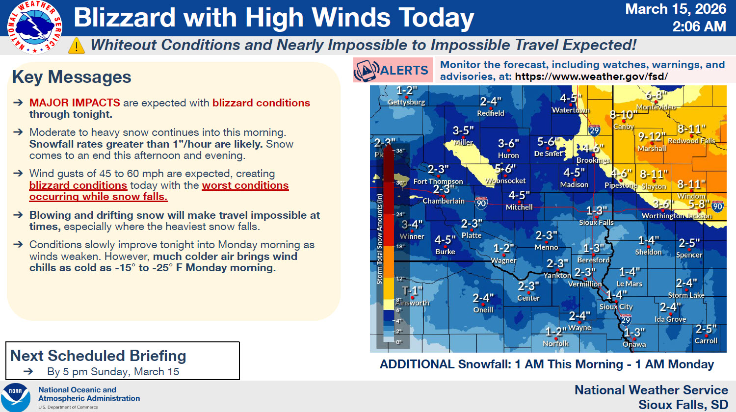 |
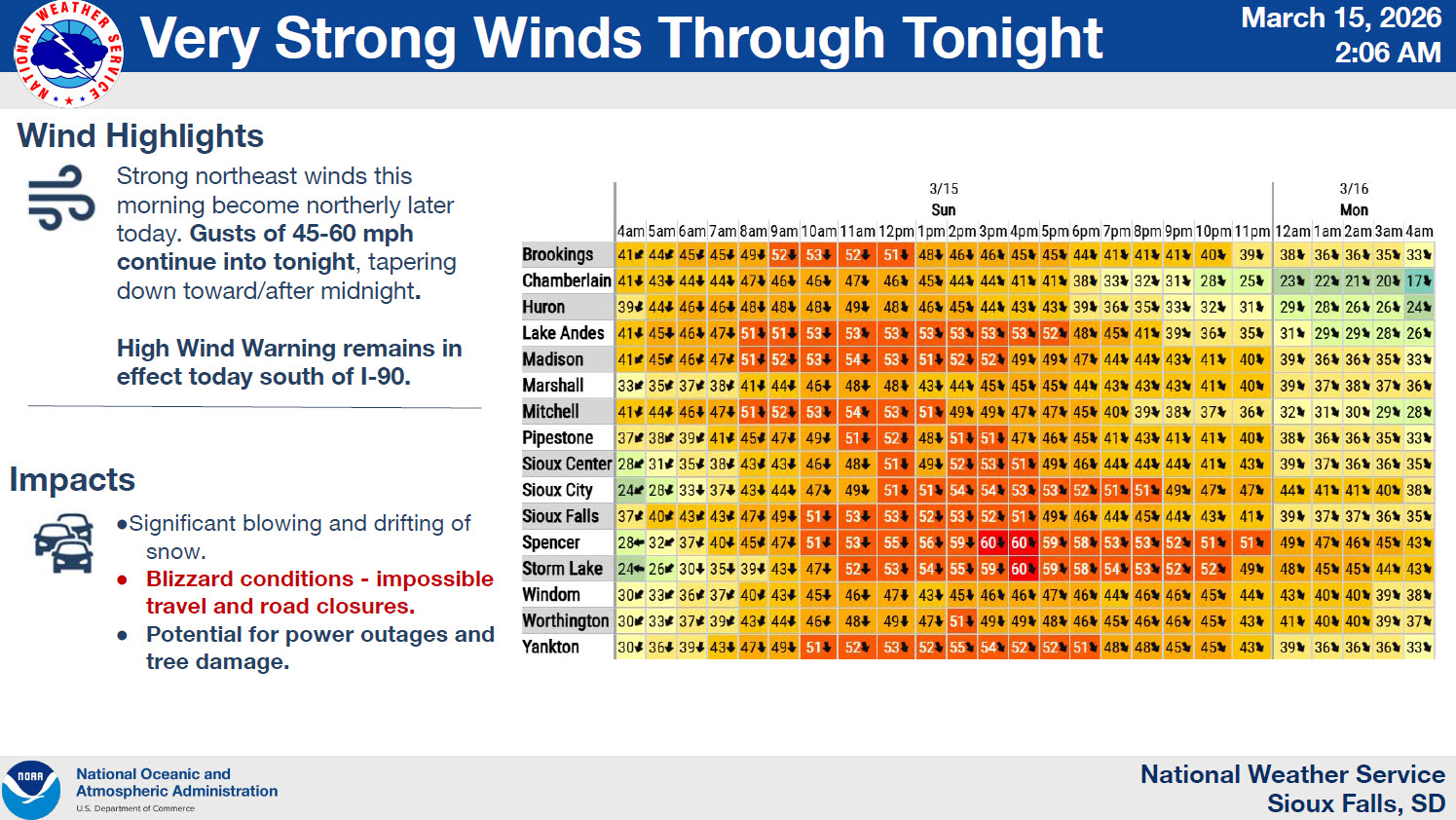 |
| NWS Sioux Falls Impact based Decision Support Services forecast packet. This slide details the impacts of the winter storm. | NWS Sioux Falls Impact based Decision Support Services forecast packet. This slide details the very strong winds expected to result in blizzard conditions. |
 |
Media use of NWS Web News Stories is encouraged! Please acknowledge the NWS as the source of any news information accessed from this site. |
|


 Weather Story
 Weather Map
 Local Radar