Overview
|
A cluster of thunderstorms moved across far southeast South Dakota and into northwest Iowa during the afternoon of June 11th, producing damaging wind gusts from 60 to 80 mph. Damage reports spread across Lyon, Osceola, Dickinson, and Clay Counties in northwest Iowa, including downed trees, power lines, and some structural damage to outbuildings and roofs. |
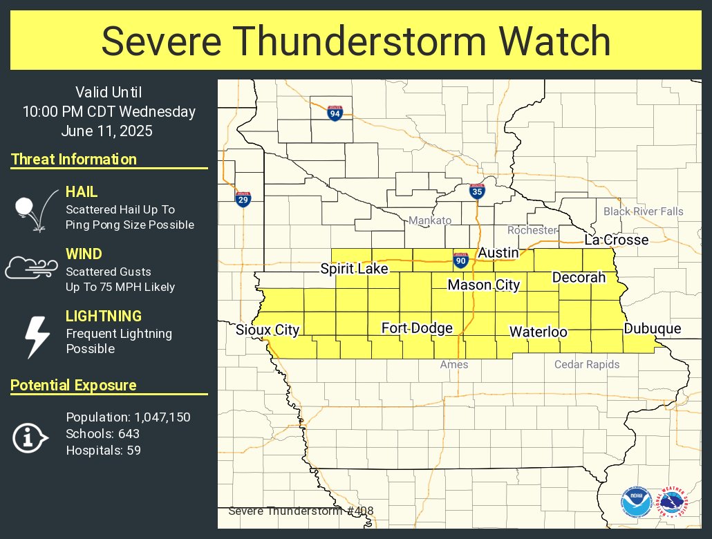 June 11, 2025 Severe Thunderstorm Watch |
Storm Reports
Preliminary Local Storm Report...Summary
National Weather Service Sioux Falls SD
1028 PM CDT Wed Jun 11 2025

..TIME...   ...EVENT...      ...CITY LOCATION...     ...LAT.LON...
..DATE...   ....MAG....      ..COUNTY LOCATION..ST.. ...SOURCE....
            ..REMARKS..

0117 PM     Tstm Wnd Gst     2 S Lester              43.41N 96.33W
06/11/2025  M56 MPH          Lyon               IA   Public

            Personal weather station.

0126 PM     Tstm Wnd Dmg     Rock Rapids             43.43N 96.17W
06/11/2025                   Lyon               IA   Broadcast Media

            Trees reported down in Rock Rapids. Time
            estimated from radar.

0131 PM     Tstm Wnd Dmg     4 NE Rock Rapids        43.46N 96.11W
06/11/2025                   Lyon               IA   Emergency Mngr

            Roof blown off hog barn. Time estimated from
            radar.

0131 PM     Tstm Wnd Gst     2 SE Rock Rapids        43.40N 96.14W
06/11/2025  M59 MPH          Lyon               IA   Public

            Personal weather station.

0135 PM     Tstm Wnd Dmg     7 N George              43.44N 96.02W
06/11/2025                   Lyon               IA   Broadcast Media

            Machine shed and empty grain bin destroyed.
            Semi truck tipped.

0135 PM     Tstm Wnd Gst     4 SSE Rock Rapids       43.37N 96.14W
06/11/2025  M62 MPH          Lyon               IA   Public

            Personal weather station.

0145 PM     Tstm Wnd Dmg     3 SSW Little Rock       43.40N 95.89W
06/11/2025                   Lyon               IA   Emergency Mngr

            Cattle barn significantly damaged. Time
            estimated from radar.

0150 PM     Tstm Wnd Dmg     1 N Little Rock         43.46N 95.88W
06/11/2025                   Lyon               IA   Trained Spotter

            Trees are down from thunderstorm wind gusts.
            Time estimated from radar.

0156 PM     Tstm Wnd Dmg     Sibley                  43.40N 95.75W
06/11/2025                   Osceola            IA   Emergency Mngr

            Roof blown off shed. Time estimated from
            radar.

0156 PM     Tstm Wnd Dmg     Sibley                  43.40N 95.74W
06/11/2025                   Osceola            IA   Fire Dept/Rescue

            Trees reported down in Sibley. Time
            estimated from radar.

0200 PM     Tstm Wnd Gst     3 NE Sibley             43.43N 95.71W
06/11/2025  M73 MPH          Osceola            IA   Mesonet

            Mesonet station RSYI4 Sibley. Time estimated
            from radar.

0201 PM     Tstm Wnd Dmg     4 ENE Sibley            43.43N 95.67W
06/11/2025                   Osceola            IA   Emergency Mngr

            Lean-to damaged along Hwy 9. Time estimated
            from radar.

0203 PM     Tstm Wnd Dmg     5 E Sibley              43.40N 95.65W
06/11/2025                   Osceola            IA   Emergency Mngr

            3/4 mile of power poles knocked down by
            thunderstorm wind gusts.

0205 PM     Tstm Wnd Gst     4 NNE Sibley            43.46N 95.71W
06/11/2025  M61 MPH          Osceola            IA   Public

            Personal weather station.

0223 PM     Tstm Wnd Gst     2 SW Harris             43.43N 95.46W
06/11/2025  E60 MPH          Osceola            IA   Emergency Mngr

            Estimated wind gust of 60 mph. A lot of
            blowing dust.

0229 PM     Tstm Wnd Gst     7 ENE Melvin            43.32N 95.48W
06/11/2025  M60 MPH          Osceola            IA   Public

            Personal weather station reported 60 mph
            gust.

0243 PM     Tstm Wnd Gst     3 SSE Lake Park         43.40N 95.31W
06/11/2025  M58 MPH          Dickinson          IA   CO-OP Observer

            Pea sized hail accompanied 58 mph
            thunderstorm wind gusts.

0254 PM     Hail             Brunsville              42.81N 96.28W
06/11/2025  E1.00 Inch       Plymouth           IA   Public

            Mostly dime to nickel sized hail, but some
            as big as a quarter. Briefly heavy rainfall
            from the thundesrstorm.

0254 PM     Tstm Wnd Dmg     3 NW Fostoria           43.27N 95.21W
06/11/2025                   Dickinson          IA   Emergency Mngr

            Tree damage in the vicinity of 190th Avenue
            and 260th Street. Time estimated from radar.

0256 PM     Tstm Wnd Dmg     3 W Fostoria            43.24N 95.21W
06/11/2025                   Clay               IA   Emergency Mngr

            Two trees down along 280th street.

0300 PM     Hail             1 W Spirit Lake         43.42N 95.13W
06/11/2025  M0.75 Inch       Dickinson          IA   Public


0302 PM     Tstm Wnd Dmg     Milford                 43.33N 95.15W
06/11/2025                   Dickinson          IA   Emergency Mngr

            Large tree branch down from 50-60 mph
            thunderstorm wind gust. Time estimated from
            radar.

0306 PM     Tstm Wnd Gst     2 WSW Terril            43.30N 95.01W
06/11/2025  M59 MPH          Dickinson          IA   Mesonet

            Mesonet station FW7399 TERRIL.

0839 PM     Hail             1 N Brandon             43.60N 96.58W
06/11/2025  M0.75 Inch       Minnehaha          SD   Public
Radar
 |
|||
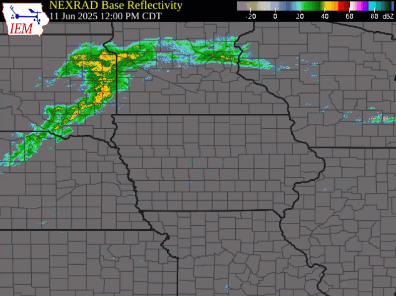
| Radar and Watches/Warnings from 12:00 pm to 6:30 pm, June 11, 2025 Courtesy of ISU IEM |
Photos & Video
| Caption (source) |
Caption (source) |
Caption (source) |
Caption (source) |
 |
Media use of NWS Web News Stories is encouraged! Please acknowledge the NWS as the source of any news information accessed from this site. |
|


 Weather Story
 Weather Map
 Local Radar