Overview
|
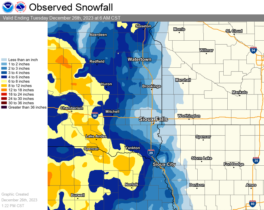
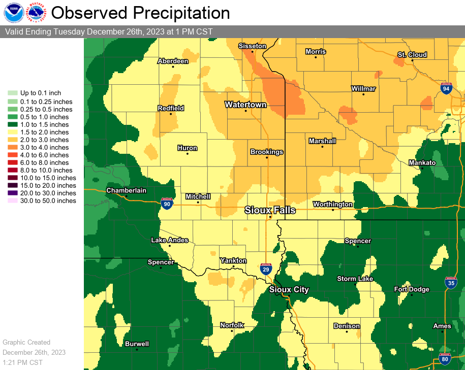
A strong winter storm impacted the region beginning on Saturday December 23 through Tuesday, December 26. Strong winds gusting between 35 and 50 mph and 4 to 10 inches of snow produced blizzard conditions west of the James River. Meanwhile 1/4 to 1/2 inch of ice fell in portions of southwestern Minnesota and northwestern Iowa, resulting in a few power outages and downed tree limbs. Many areas also received significant liquid precipitation, with 1 to 2+ inches common across the region. Three locations broke 3-day December precipitation records.
Note that snow, ice, and liquid precipitation observations listed below are through the morning of December 26, 2023. |
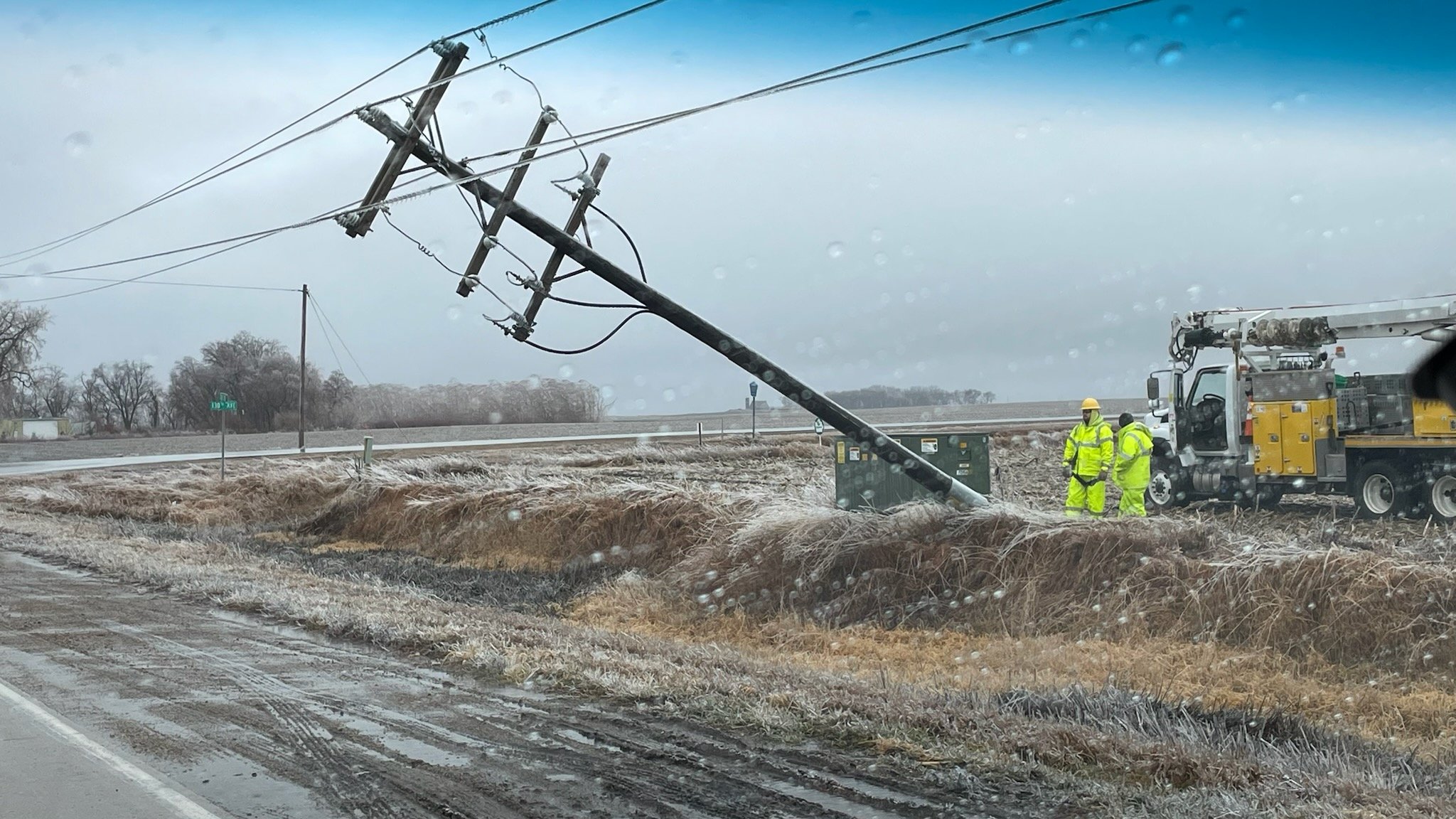 Image of a power pole that was partially knocked down from a combination of ice and strong winds on Christmas Day. Photo courtesy of Dickinson County Emergency Management |
Snow/Ice/Rainfall
Observed Snowfall from December 24-26, 2023
| Location | Snowfall (in.) | Location | Ice Accumulation (in.) |
| Gregory, SD | 13.8 | 2 miles WNW of Currie, MN | 0.5 |
| 4 miles SW of Burke, SD | 11.0 | Orange City, IA | 0.33 |
| 4 miles SW of Stickney, SD | 9.0 | 7 miles ESE of Westfield, IA | 0.3 |
| 2 miles SSE of Wessington, SD | 8.0 | 2 miles NNW of Cherokee, IA | 0.25 |
| 2 miles ESE of Yankton, SD | 7.0 | Le Mars, IA | 0.25 |
| Chamberlain, SD | 6.6 | 1 mile N of Hospers, IA | 0.25 |
| 6 miles SSE of Herrick, SD | 6.5 | Marshall, MN | 0.25 |
| 2 miles S of Huron, SD | 6.3 | 2 miles NE of Worthington, MN | 0.2 |
| Wessington Springs, SD | 6.0 | 8 miles S of Lake Park, IA | 0.2 |
| 1 mile SSE of Vermillion, SD | 6.0 | Sanborn, IA | 0.2 |
| Tyndall, SD | 6.0 | Sioux Falls Airport, SD | 0.15 |
| 4 miles N of Martinsburg, NE | 6.0 | 3 miles SSE of Lake Park, IA | 0.13 |
| 7 miles N of Thurston, NE | 6.0 | Hull, IA | 0.13 |
| Newcastle, NE | 6.0 | Westbrook, MN | 0.1 |
| 2 miles WNW of Ponca, NE | 6.0 | ||
| Menno, SD | 5.0 | ||
| 1 mile SE of Mitchell, SD | 5.0 | ||
| Concord, NE | 5.0 | ||
| 12 miles WNW of Platte, SD | 4.5 | ||
| 10 miles ENE of Corsica, SD | 4.0 | ||
| Emerson, NE | 4.0 | ||
| 1 mile W of Alexandria, SD | 3.0 | ||
| Homer, NE | 3.0 | ||
| 3 miles SSE of North Sioux City, SD | 2.0 | ||
| Marion, SD | 2.0 | ||
| 4 miles ENE of Salem, SD | 2.0 | ||
| Montrose, SD | 2.0 | ||
| De Smet, SD | 1.5 | ||
| Sioux City Airport, IA | 1.5 | ||
| Hartford, SD | 1.1 | ||
| Flandreau, SD | 1.0 | ||
| 1 mile SSW of Howard, SD | 1.0 | ||
| Sioux Falls Airport, SD | 0.9 | ||
| 1 mile NNW Canton, SD | 0.7 | ||
| 2 miles NE of Brookings, SD | 0.7 | ||
| Edgerton, MN | 0.5 | ||
| 8 miles SE of Hendricks, MN | 0.2 |
Observed Precipitation from December 23-26, 2023
| Location | Rainfall (in.) | Location | Rainfall (in.) |
| 4 miles S of Cottonwood, MN | 2.70 | 1 mile SE of Mitchell, SD | 1.42 |
| Marshall, MN | 2.52 | Yankton, SD | 1.41 |
| 4 miles SW of Stickney, SD | 2.45 | 4 miles S of Worthington, MN | 1.40 |
| Brookings, SD | 2.29 | Elkton, SD | 1.39 |
| Montrose, SD | 2.26 | Russell, MN | 1.34 |
| Aurora, SD | 2.25 | 11 miles W of Dimock, SD | 1.29 |
| 5 miles NNW of Jackson, MN | 2.20 | Canton, SD | 1.29 |
| 2 miles NE of Academy, SD | 2.15 | 2 miles NE of Sherman, MN | 1.26 |
| 7 miles NNW of Brookings, SD | 2.01 | 11 miles S of Emery, SD | 1.25 |
| 4 miles ESE of Sioux Falls, SD | 2.01 | Le Mars, IA | 1.21 |
| 5 miles W of Garretson, SD | 1.98 | Forestburg, SD | 1.19 |
| 1 mile S of Brookings, SD | 1.95 | North Sioux City, IA | 1.17 |
| Edgerton, MN | 1.92 | Huron Airport, SD | 1.16 |
| Lake Park, MN | 1.88 | Sioux City Airport, IA | 1.10 |
| NWS Sioux Falls, SD | 1.88 | 4 miles SE of Hardwick, MN | 1.10 |
| De Smet, SD | 1.83 | 6 miles NW of Ihlen, MN | 1.09 |
| 11 miles N of Coleman, SD | 1.83 | Corsica, SD | 1.07 |
| 4 miles NW of Renner, SD | 1.80 | 4 miles SW of of Burke, SD | 1.04 |
| Orange City, IA | 1.75 | Luverne, MN | 1.04 |
| Hurley, SD | 1.74 | 7 miles SE of Kimball, SD | 1.04 |
| 2 miles SE of Madison, SD | 1.71 | Sanborn, IA | 1.03 |
| Sibley, IA | 1.70 | 3 miles N of Sioux Center, IA | 1.02 |
| 2 miles NW of Bigelow, MN | 1.69 | 5 miles N of Pipestone, MN | 0.96 |
| 2 miles NE of Brookings, SD | 1.68 | 8 miles SE of Hendricks, MN | 0.93 |
| Sioux Falls Airport, SD | 1.67 | Gayville, SD | 0.93 |
| Hills, MN | 1.66 | 8 miles S of Dovray, MN | 0.89 |
| 1 mile NE of Cherokee, IA | 1.64 | 1 mile S of Rock Rapids, IA | 0.88 |
| 1 mile SSE of Milford, IA | 1.63 | Hartley, IA | 0.87 |
| Sheldon, IA | 1.63 | Slayton Airport, MN | 0.87 |
| 2 miles SW of Worthington, MN | 1.63 | Ivanhoe, MN | 0.85 |
| 5 miles W of Howard, SD | 1.63 | 4 miles SE of Olivet, SD | 0.85 |
| EROS Data Center, Sioux Falls, SD | 1.61 | 6 miles NW of Orleans, MN | 0.82 |
| Orange City, IA | 1.60 | 1 mile N of Rock Valley | 0.79 |
| 1 mile E of Spirit Lake, IA | 1.59 | Sioux Center, IA | 0.77 |
| 2 miles NNE of Worthington, MN | 1.59 | Hawarden, IA | 0.76 |
| Brookings Airport, SD | 1.58 | 4 miles SW of George, IA | 0.73 |
| 11 miles SSE of Burke, SD | 1.57 | 6 miles NW of Hinton, IA | 0.72 |
| Brewster, MN | 1.56 | South Sioux City, NE | 0.59 |
| 1 mile SE of Vermillion, SD | 1.50 | 5 miles SSW of Ellsworth, IA | 0.53 |
| Gregory, SD | 1.50 | Hubbard, NE | 0.49 |
| 6 miles NW of Montrose, SD | 1.50 | ||
| 1 mile SW of Linn Grove, IA | 1.49 | ||
| Chamberlain, SD | 1.48 | ||
| 5 miles NNW of Marion, SD | 1.48 | ||
| Tripp, SD | 1.45 | ||
| 7 miles S of Spencer, IA | 1.44 | ||
| 4 miles E of Montrose, SD | 1.44 | ||
| Tyndall, SD | 1.43 | ||
| 7 miles NNE of Huron, SD | 1.42 |
Photos & Video
 |
 |
 |
 |
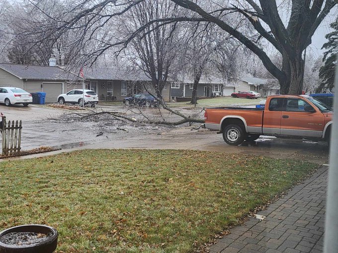
| Image of branches down in Le Mars, Iowa due to freezing rain on Christmas Day. Photo courtesy of David Skou |
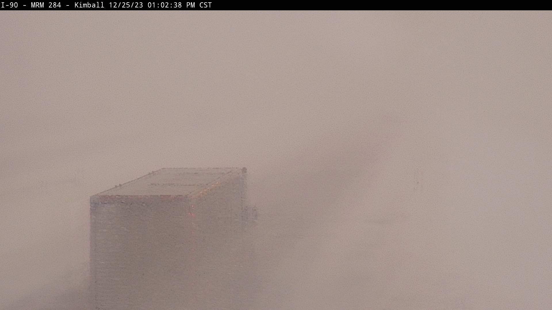
Near zero visibility on I-90 near Kimball, South Dakota during the afternoon of December 25. Photo courtesy of the South Dakota Department of Transportation |
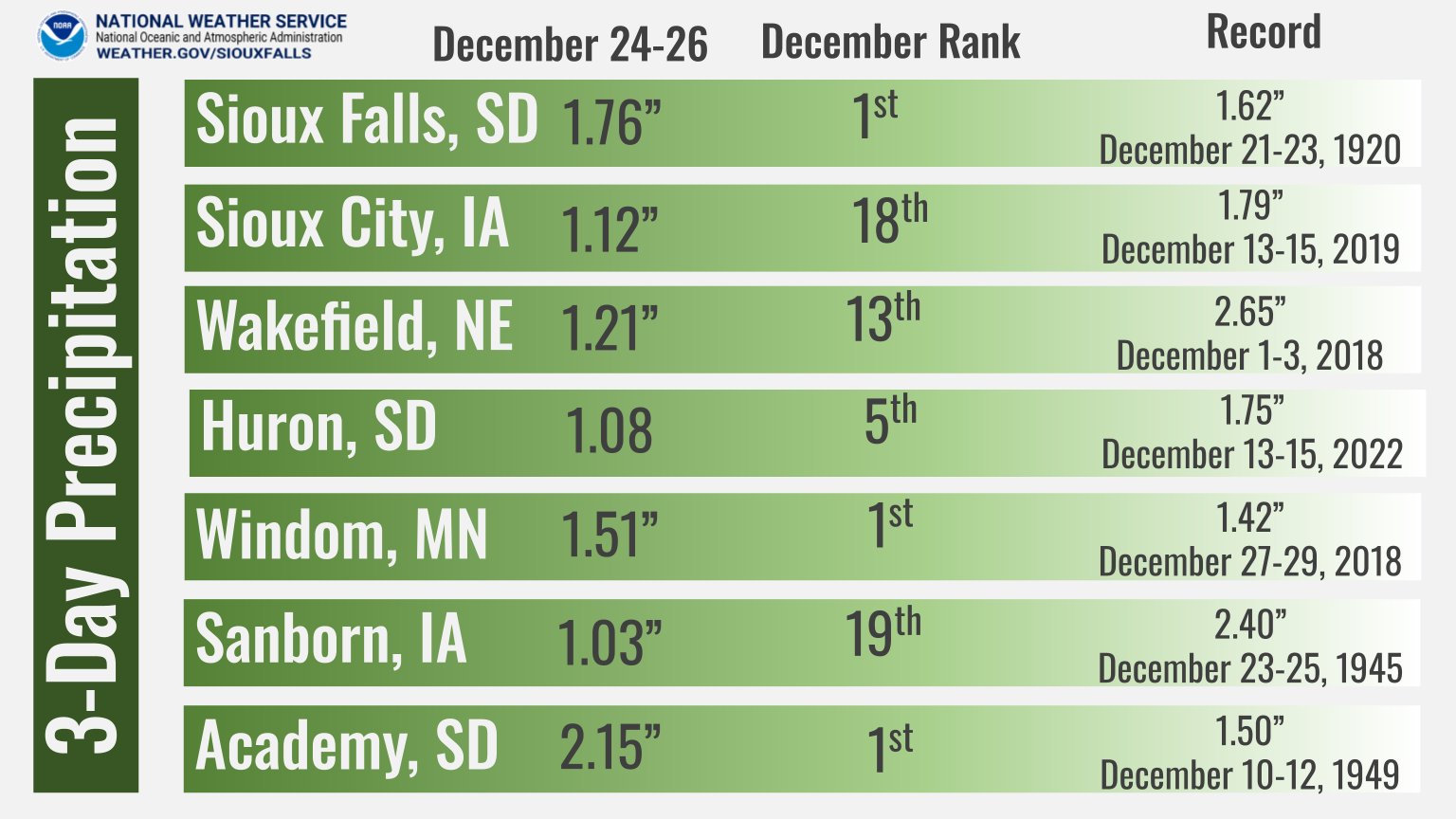
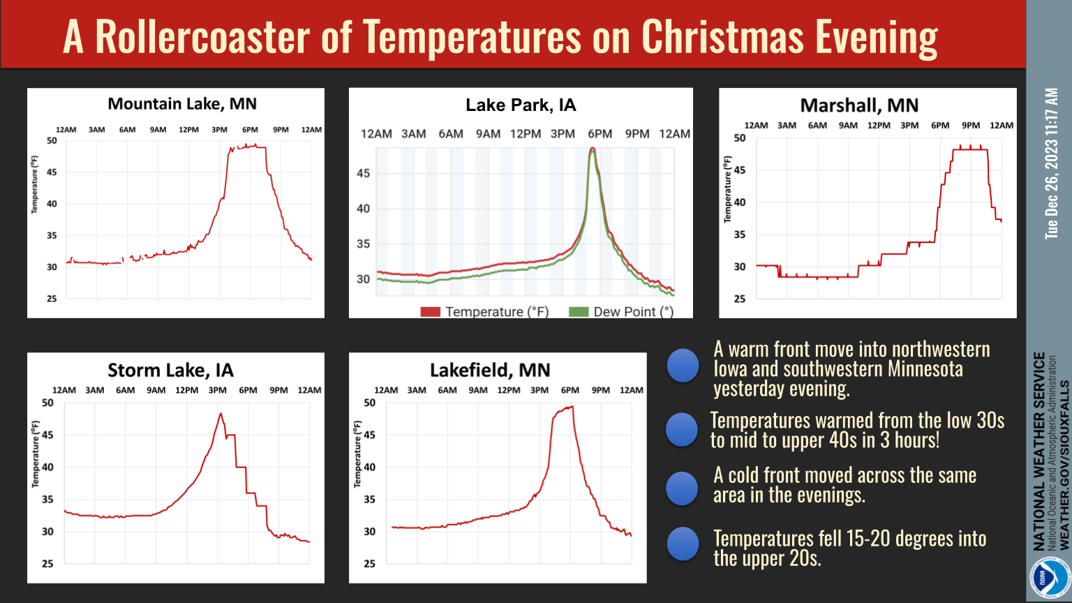
Here are a list of 7 locations and where the 3-day total precipitation ranked for December. For Sioux Falls, Windom, and Academy it was the heaviest 3-day rainfall ever recorded in December. | Temperatures rose 15-20 degrees in the afternoon in parts of Iowa and Minnesota as a warm front moved through. A cold front then came through in the evening dropping temperatures by 20 degrees. |
Radar
 |
 |
 |
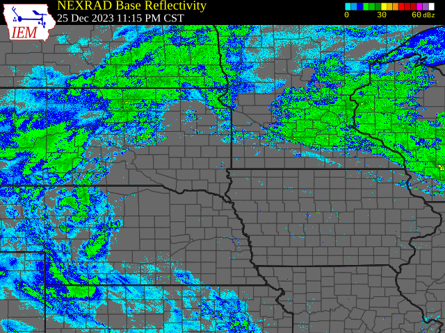 |
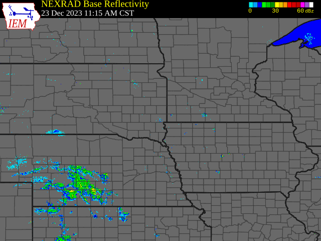
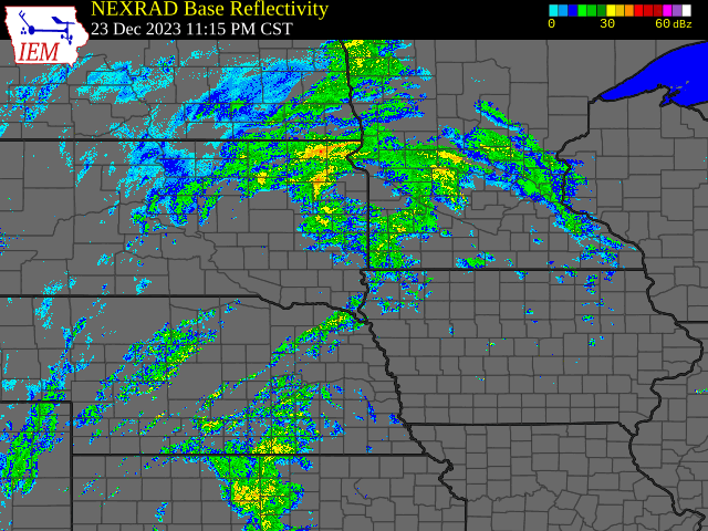
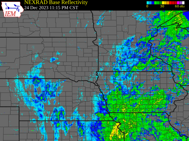
| Radar loop of the beginning of the event during the afternoon and evening of December 23, 2023 | Radar loop of the first round of heavy rainfall that occurred December 24, 2023. | Radar loop of the second round of rain, sleet, freezing rain and snow that occurred on December 25, 2023. | Radar loop of the end of the storm on December 26, 2023. |
Wind
| Location | Wind Gust (mph) |
| Plankinton (SDDOT) | 56 |
| Platte-Winner Bridge (SDDOT) | 50 |
| Ft. Randall Dam (SDDOT) | 50 |
| Kimball (SDDOT) | 50 |
| Dallas (SDDOT) | 50 |
| Dixon (SDDOT) | 49 |
| Lane (SDDOT) | 47 |
| Corsica (SDDOT) | 46 |
| Wolsey (SDDOT) | 45 |
| Tripp (SDDOT) | 45 |
| Huron Regional Airport | 45 |
| Florence (MNDOT) | 44 |
| Lake Andes RAWS | 44 |
| 2ESE Wessington Springs | 43 |
| Chamberlain Municipal Airport | 43 |
| White Lake (SD Mesonet) | 43 |
| Tyndall (SDDOT) | 42 |
| Wagner (SDDOT) | 42 |
| Forestburg (SDDOT) | 42 |
| Magnolia (MNDOT) | 42 |
| Davis (SDDOT) | 40 |
| Cavour (SDDOT) | 40 |
| Stanley Corner (SDDOT) | 40 |
| Taunton (MNDOT) | 40 |
 |
Media use of NWS Web News Stories is encouraged! Please acknowledge the NWS as the source of any news information accessed from this site. |
|


 Weather Story
 Weather Map
 Local Radar