Overview
Severe weather impacted portions of the area on consecutive evenings, Thursday August 10 and Friday August 11. On Thursday, a couple of tornadoes were reported in addition to large hail across southeastern South Dakota. No damage or injuries were reported from these short lived tornadoes. Storms Thursday developed over central South Dakota and moved east/southeast. Large hail and gusty winds impacted portions of southwestern Minnesota and northwestern Iowa on Friday evening, as storms developed and moved east/southeast into these areas.
Data for tornadoes is still considered preliminary and we're still gathering reports; so check back for updates!
Tornadoes:
|
Tornado #1 - Mud Lake
Track Map 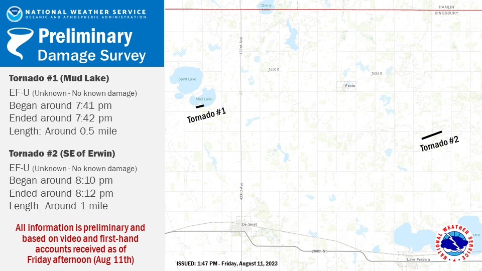 
Downloadable KMZ File |
||||||||||||||||
|
Tornado #2 - Northeast of Lake Preston
Track Map
Downloadable KMZ File |
||||||||||||||||
The Enhanced Fujita (EF) Scale classifies tornadoes into the following categories:
| EF0 Weak 65-85 mph |
EF1 Moderate 86-110 mph |
EF2 Significant 111-135 mph |
EF3 Severe 136-165 mph |
EF4 Extreme 166-200 mph |
EF5 Catastrophic 200+ mph |
 |
|||||
Hail:
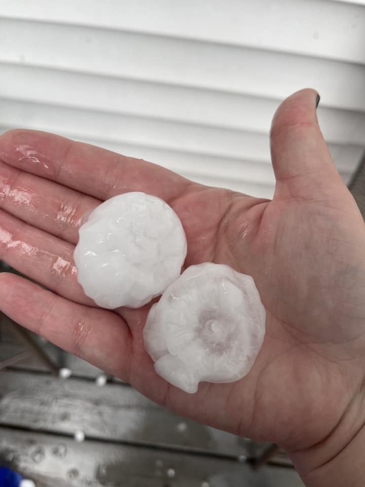
Hail
Here's a look at some of the hail which fell Thursday and Friday.
 |
 |
||
| Hail Thursday southeast of Alexandria, SD (Jamie Watembach) |
Hail Thursday near Lake Thompson, SD (Morgan Larson) |
Caption (source) |
Caption (source) |
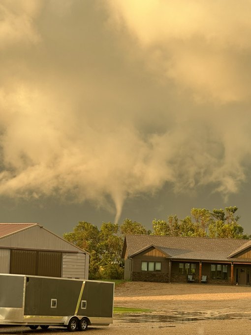
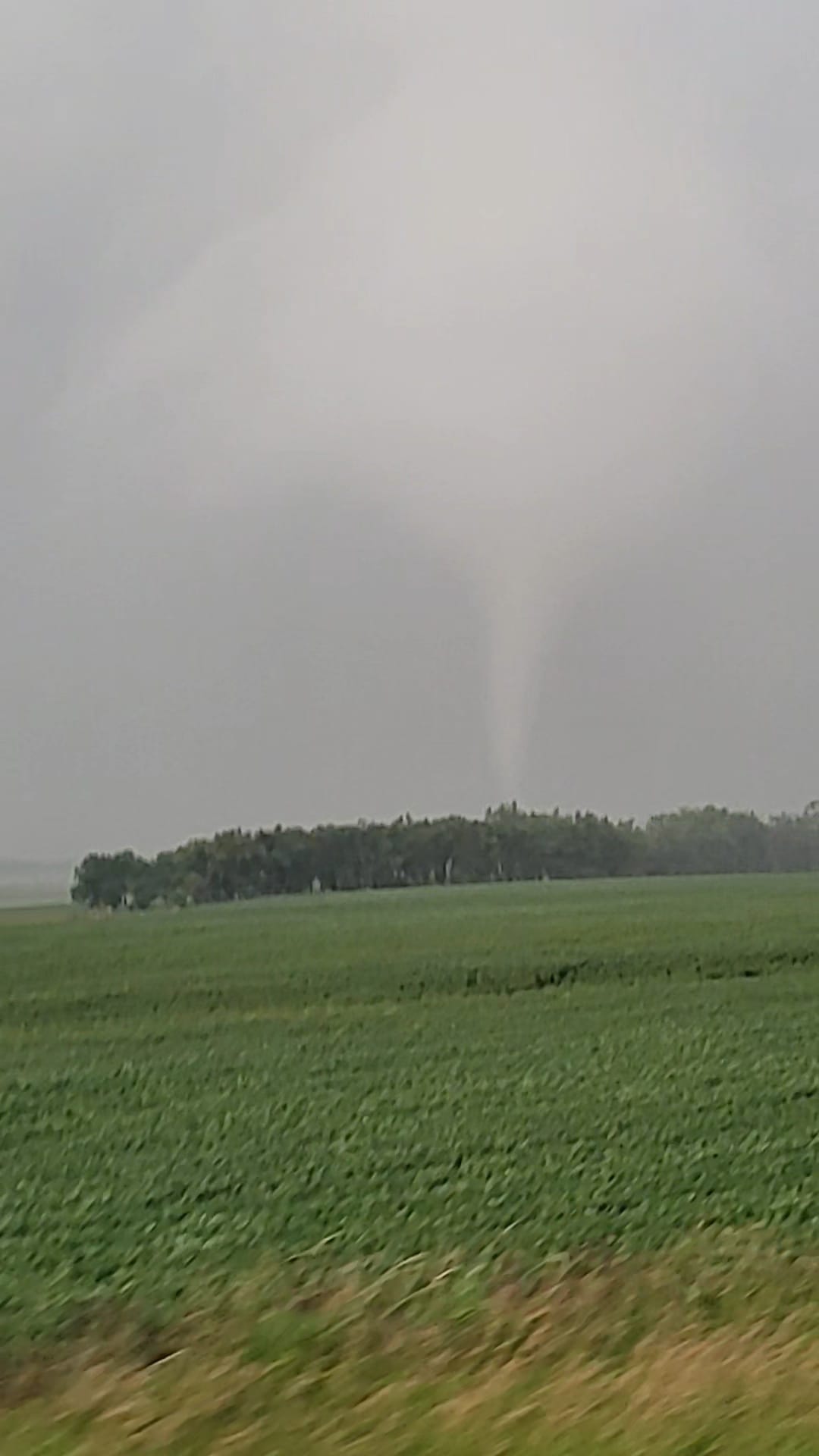
Photos & Video
Check out these additional photos!
 |
 |
 |
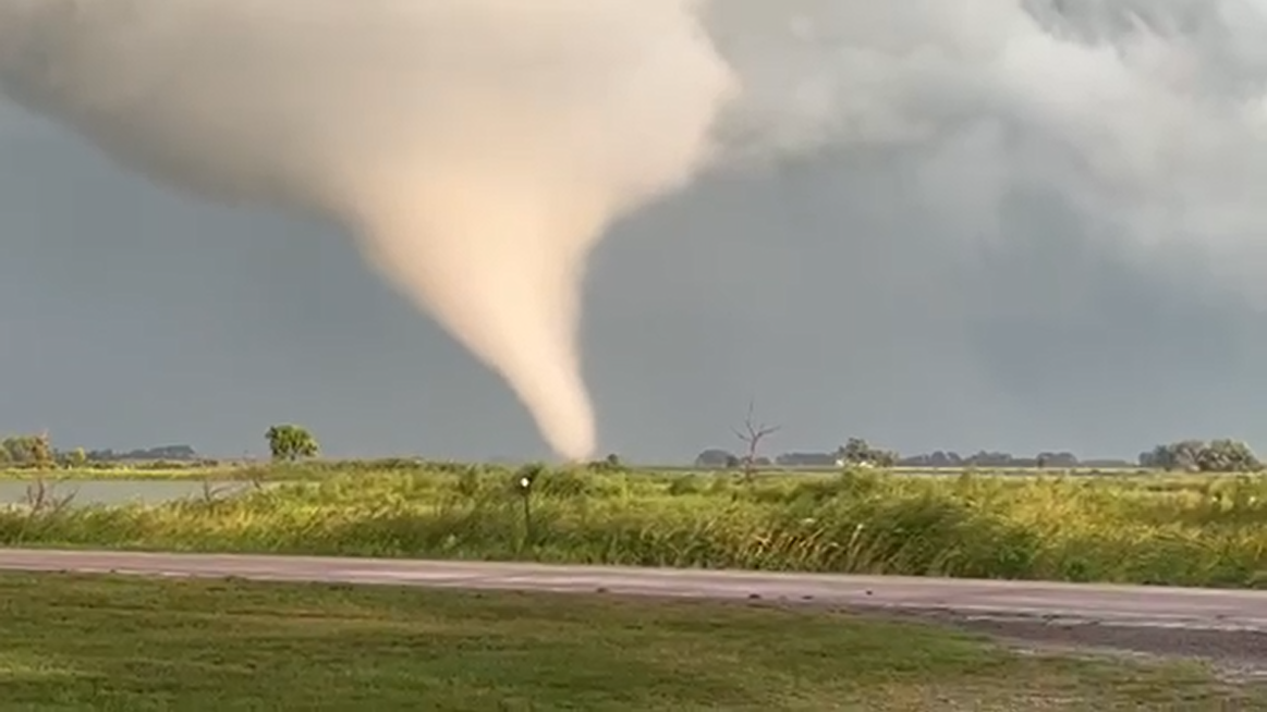 |
| Tornado North of Lake Preston, SD (Jack Hasche) |
Tornado East of Willow Lake, SD (Heath Seefeldt) |
Storm Structure North of Bridgewater, SD (McCook county EM) |
Video Capture of Tornado Near Spirit Lake, SD (Bob Springer) |
Radar
Radar loops, roughly four hours each, to encompass both nights of severe weather.
 |
 |
 |
 |
| Radar Loop from 5 PM to 9 PM Thursday. | Radar loop from 9 PM Thursday to 1 AM Friday. | Radar loop from 3 PM to 7 PM Friday. | Radar loop from 7 PM to 11 PM Friday. |
Storm Reports
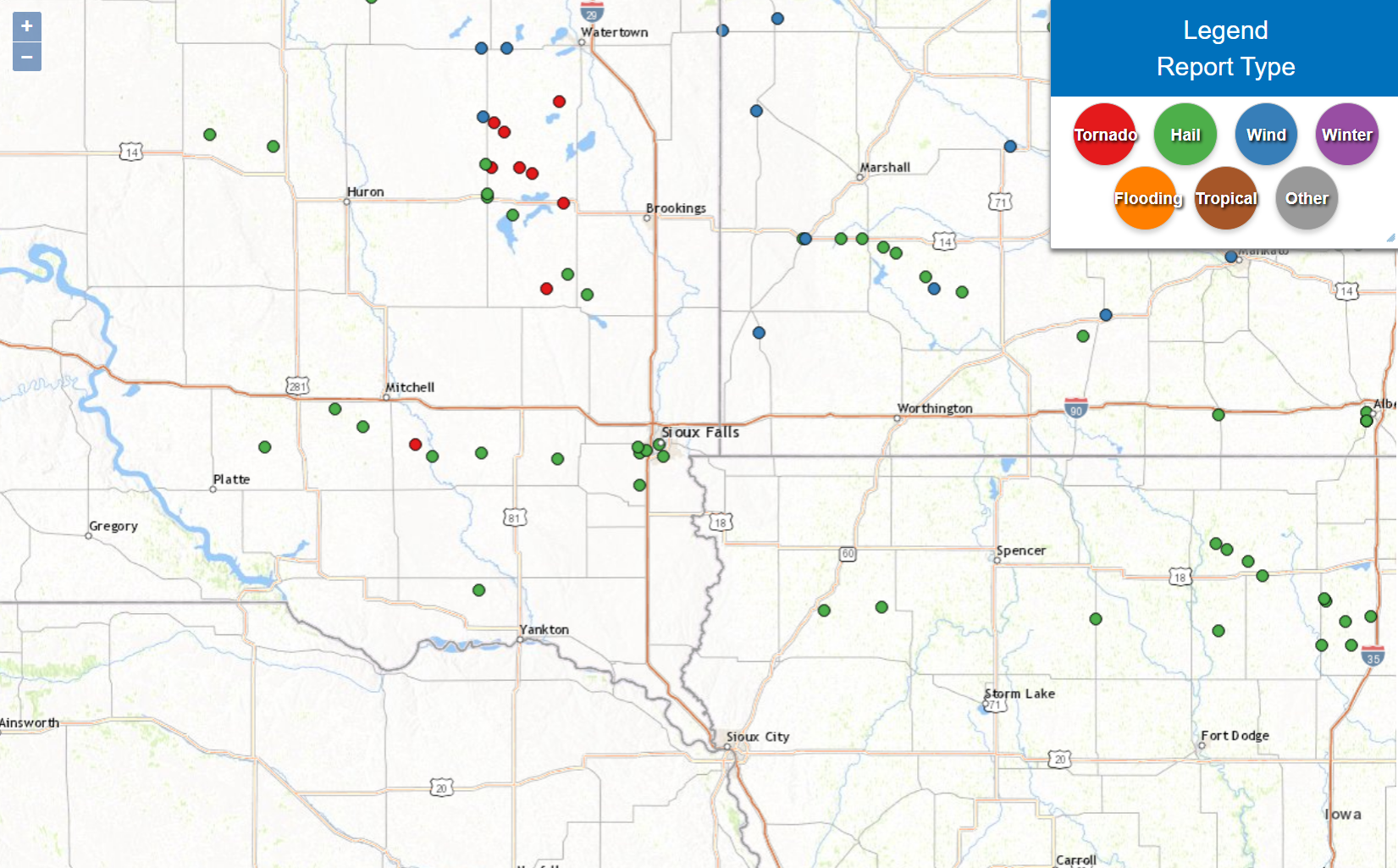
Preliminary Local Storm Report...Summary
National Weather Service Sioux Falls SD
920 PM CDT Sat Aug 12 2023

..TIME...   ...EVENT...      ...CITY LOCATION...     ...LAT.LON...
..DATE...   ....MAG....      ..COUNTY LOCATION..ST.. ...SOURCE....
            ..REMARKS..

0753 PM     Hail             Paullina                42.98N 95.69W
08/11/2023  E0.70 inch       O`Brien            IA   Public

            Report via social media. Dime sized hail,
            winds strong enough to splatter leaves on
            the sides of houses and vehicles, and 1.50
            inches rainfall.

0734 PM     Hail             3 ESE Alton             42.97N 95.96W
08/11/2023  E0.50 inch       Sioux              IA   Public

            Report from mPING: Half-inch (0.50 in.).

0505 PM     Hail             1 NNE Storden           44.06N 95.31W
08/11/2023  E0.75 inch       Cottonwood         MN   Public

            Trained spotter reported pea to dime sized
            hail just north of Storden. Time estimated
            via radar.

0458 PM     Tstm Wnd Dmg     2 N Westbrook           44.07N 95.44W
08/11/2023                   Cottonwood         MN   Public

            Report from m:PING: Small tree branches
            broken.

0456 PM     Hail             5 NE Dovray             44.11N 95.48W
08/11/2023  E0.88 inch       Murray             MN   Public

            Trained spotter reported dime to nickel
            sized hail northeast of Dovray. Time
            estimated with radar.

0447 PM     Hail             3 S Tracy               44.19N 95.62W
08/11/2023  E0.25 inch       Murray             MN   Public

            Report via social media. Pea sized hail
            along with 0.50 inch rainfall.

0429 PM     Hail             Balaton                 44.24N 95.88W
08/11/2023  E1.25 inch       Lyon               MN   Public

            Report from mPING: Half Dollar (1.25 in.).

0424 PM     Hail             3 WSW Tracy             44.21N 95.68W
08/11/2023  E0.75 inch       Lyon               MN   Emergency Mngr

            The Murray County EM reported Dime sized
            hail southwest of Tracy. Time estimated via
            radar.

0419 PM     Hail             Florence                44.24N 96.06W
08/11/2023  E1.00 inch       Lyon               MN   Trained Spotter

            Pea size transitioned to quarter sized hail
            after initial call.

0419 PM     Tstm Wnd Gst     Florence                44.24N 96.05W
08/11/2023  M56 MPH          Lyon               MN   Mesonet

            Mesonet station MN160 U.s.14 - Florence - Mp
            21.2. Time estimated with radar.

0417 PM     Tstm Wnd Gst     2 N Trosky              43.92N 96.27W
08/11/2023  M53 MPH          Pipestone          MN   Mesonet

            Mesonet station MN154 U.s.75 - Trosky - Mp
            30.3. Time estimated from radar.

0409 PM     Hail             2 NNW Garvin            44.24N 95.78W
08/11/2023  E1.00 inch       Lyon               MN   CO-OP Observer

            A COOP observer reported quarter sized hail
            8 miles west of Tracy. The time was
            estimated via radar.

1002 PM     Hail             Sioux Falls             43.54N 96.74W
08/10/2023  E0.50 inch       Minnehaha          SD   Public

            Report from mPING: Half-inch (0.50 in.).

0958 PM     Hail             3 S Sioux Falls         43.50N 96.72W
08/10/2023  E0.50 inch       Minnehaha          SD   Public

            Report from mPING: Half-inch (0.50 in.).

0951 PM     Hail             4 WSW Sioux Falls       43.52N 96.80W
08/10/2023  E0.75 inch       Minnehaha          SD   Public

            Report via social media. Location and time
            estimated from radar.

0949 PM     Hail             4 N Tea                 43.51N 96.83W
08/10/2023  E0.75 inch       Minnehaha          SD   Public

            Report from mPING: Dime (0.75 in.).

0949 PM     Hail             5 W Sioux Falls         43.53N 96.84W
08/10/2023  E0.50 inch       Minnehaha          SD   Public

            Report from mPING: Half-inch (0.50 in.).

0927 PM     Hail             4 S Tea                 43.40N 96.83W
08/10/2023  E0.75 inch       Lincoln            SD   Public

            Report from mPING: Dime (0.75 in.).

0906 PM     Hail             3 NNE Madison           44.05N 97.08W
08/10/2023  E1.00 inch       Lake               SD   Trained Spotter


0904 PM     Hail             Monroe                  43.49N 97.22W
08/10/2023  E1.25 inch       Turner             SD   Public

            Public report of quarter to half dollar
            sized hail. Time estimated by radar.

0847 PM     Funnel Cloud     4 SW Ramona             44.07N 97.27W
08/10/2023                   Lake               SD   Storm Chaser

            Person was 2 miles southwest of Ramona
            looking to the west.

0846 PM     Hail             Lesterville             43.04N 97.59W
08/10/2023  U1.75 inch       Yankton            SD   Emergency Mngr


0844 PM     Hail             2 E Ramona              44.12N 97.17W
08/10/2023  E1.25 inch       Lake               SD   Storm Chaser


0830 PM     Funnel Cloud     2 ESE Hetland           44.36N 97.19W
08/10/2023                   Kingsbury          SD   Fire Dept/Rescue

            Arlington Fire Department reported funnel.
            Radar rotation confirmed time of report.

0815 PM     Tornado          2 E Erwin               44.48N 97.40W
08/10/2023                   Kingsbury          SD   Emergency Mngr

            Kingsbury EM called to report tornado on the
            ground following 200th st, approximately 4
            east of 441st ave.

0810 PM     Tornado          5 ESE Erwin             44.46N 97.34W
08/10/2023                   Kingsbury          SD   Public

            Video of tornado via social media.

0806 PM     Hail             5 WSW Bridgewater       43.51N 97.58W
08/10/2023  E1.50 inch       McCook             SD   Public

            Delayed social media report of Ping-Pong
            Ball sized hail. Time estimated via Radar.

0801 PM     Hail             4 SW Lake Preston       44.32N 97.43W
08/10/2023  E1.50 inch       Kingsbury          SD   Public

            Report via social media. Time and location
            estimated by radar.

0748 PM     Tornado          4 W Erwin               44.48N 97.53W
08/10/2023                   Kingsbury          SD   Public

            Report relayed through DeSmet Fire, public
            reported tornado on the ground.

0745 PM     Hail             De Smet                 44.38N 97.55W
08/10/2023  E0.75 inch       Kingsbury          SD   Public

            Report from mPING: Dime (0.75 in.).

0745 PM     Hail             De Smet                 44.39N 97.55W
08/10/2023  E1.00 inch       Kingsbury          SD   Emergency Mngr

            EM for Kingsbury county called to report 1
            inch hail.

0744 PM     Hail             De Smet                 44.38N 97.55W
08/10/2023  E0.75 inch       Kingsbury          SD   Public

            Report from mPING: Dime (0.75 in.).

0739 PM     Funnel Cloud     5 E Ethan               43.54N 97.89W
08/10/2023                   Hanson             SD   Law Enforcement

            Multiple law enforcement agencies reported a
            funnel cloud to the southeast of this
            location. Tail was also noted on the
            backside of the storm.

0738 PM     Hail             6 W Erwin               44.49N 97.56W
08/10/2023  E1.75 inch       Kingsbury          SD   Public

            Time estimated via radar.

0736 PM     Hail             9 WNW Clayton           43.50N 97.81W
08/10/2023  E1.00 inch       Hanson             SD   Public

            Report from mPING: Quarter (1.00 in.).

0643 PM     Hail             9 WNW Ethan             43.60N 98.14W
08/10/2023  E1.00 inch       Davison            SD   Trained Spotter

            Pea to quarter sized hail, but mostly
            quarter sized.

0635 PM     Hail             4 S Mount Vernon        43.66N 98.27W
08/10/2023  E1.00 inch       Davison            SD   Public

            Report from mPING: Quarter (1.00 in.). Time
            estimated from radar.

0548 PM     Hail             9 NE Wessington         44.55N 98.56W
08/10/2023  E1.00 inch       Beadle             SD   Public

            Report and photo via social media. Largest
            stone quarter sized. Time estimated via
            radar.

0546 PM     Hail             7 NNW Harrison          43.53N 98.60W
08/10/2023  E1.00 inch       Aurora             SD   Trained Spotter
 |
Media use of NWS Web News Stories is encouraged! Please acknowledge the NWS as the source of any news information accessed from this site. |
|


 Weather Story
 Weather Map
 Local Radar