Overview
|
A supercell thunderstorm moved from Kingsbury County in South Dakota to O'Brien County in northwestern Iowa. The storm produced a swath of quarter size to baseball size hail. The largest hail was around Magnolia and Adrian in southwestern Minnesota. A few damaging wind gusts were also reported with a gust of 73 mph in Luverne, Minnesota. |
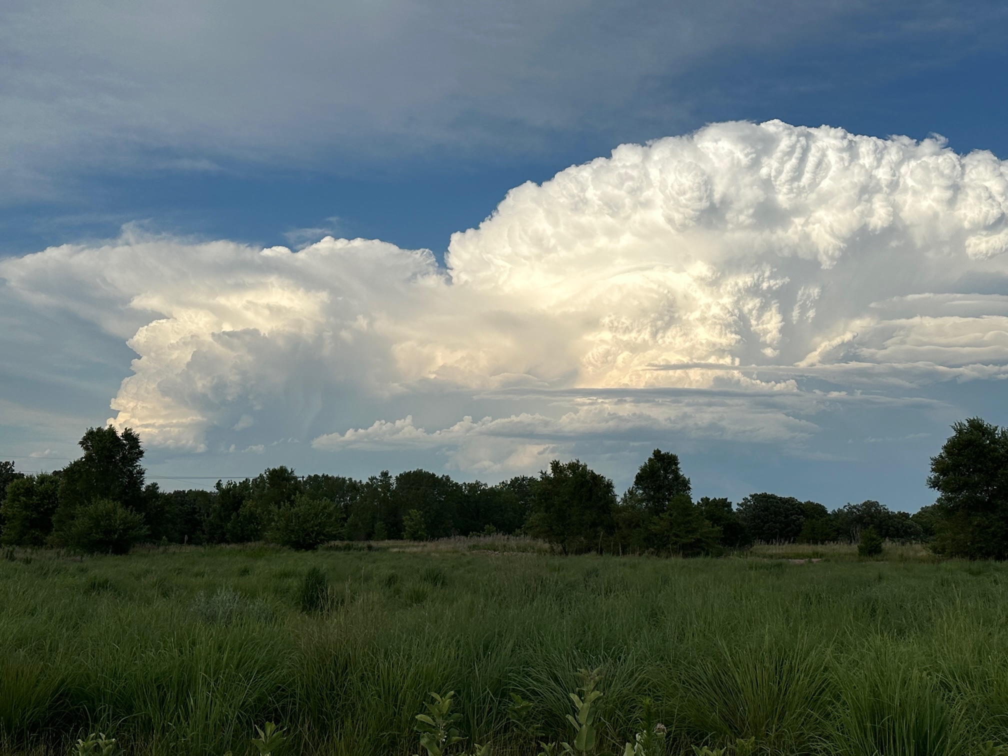 Image of supercell thunderstorm east of Luverne, Minnesota. The photo was taken from Arrowhead Park in Sioux Falls by an NWS employee. |
Hail:
Two supercells developed over east central South Dakota and southwestern Minnesota during the late afternoon of July 13th, 2023. One supercell travelled from east central South Dakota to northwestern Iowa during the late afternoon and evening. The storm produced up to golf ball size hail southwest of Brookings and again west and south of Pipestone. After briefly weakening in southern Pipestone County, the storm restrengthened and produced up to baseball size hail in eastern Rock and southwestern Nobles County in southwestern Minnesota. The storm then slowly weakened as it moved into northwestern Iowa although it was still able to produce 1 to 1.5 inch hail in Osceola and O'Brien Counties.
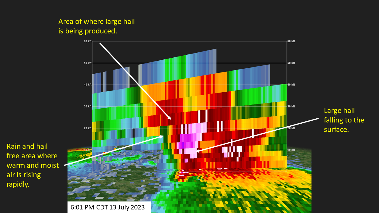
The second supercell developed in northeastern South Dakota in the late afternoon and moved into southwestern Minnesota. The storm reached its peak intensity across Lincoln County Minnesota where up to 2.5 inch hail fell near Lake Benton. As the storm continued to move southeast, it quickly weakened as it moved into southern Murray county during the early evening.
Hail images
 |
 |
 |
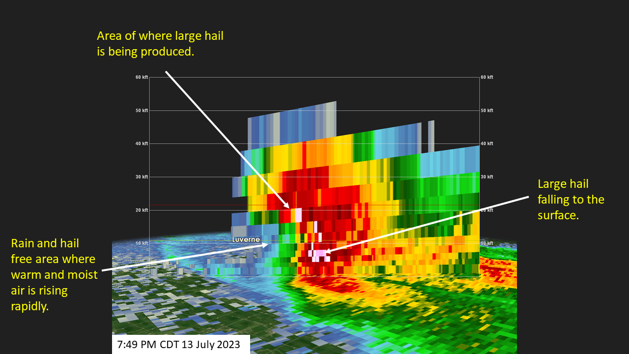 |
| Photo of person holding 2.5 inch hail that fell in Lake Benton, Minnesota. Photo courtesy of Bethany J. | Radar cross-section from 6:01 PM CDT across the supercell that produced up to 2.5 inch hail near Lake Benton, Minnesota. The hail fell at 6:12 PM CDT. | Person holding hail up to baseball size that fell 6 miles south of Adrian. Photo courtesy of Doug Neyen. | Radar cross-section |
Photos & Video
 |
 |
 |
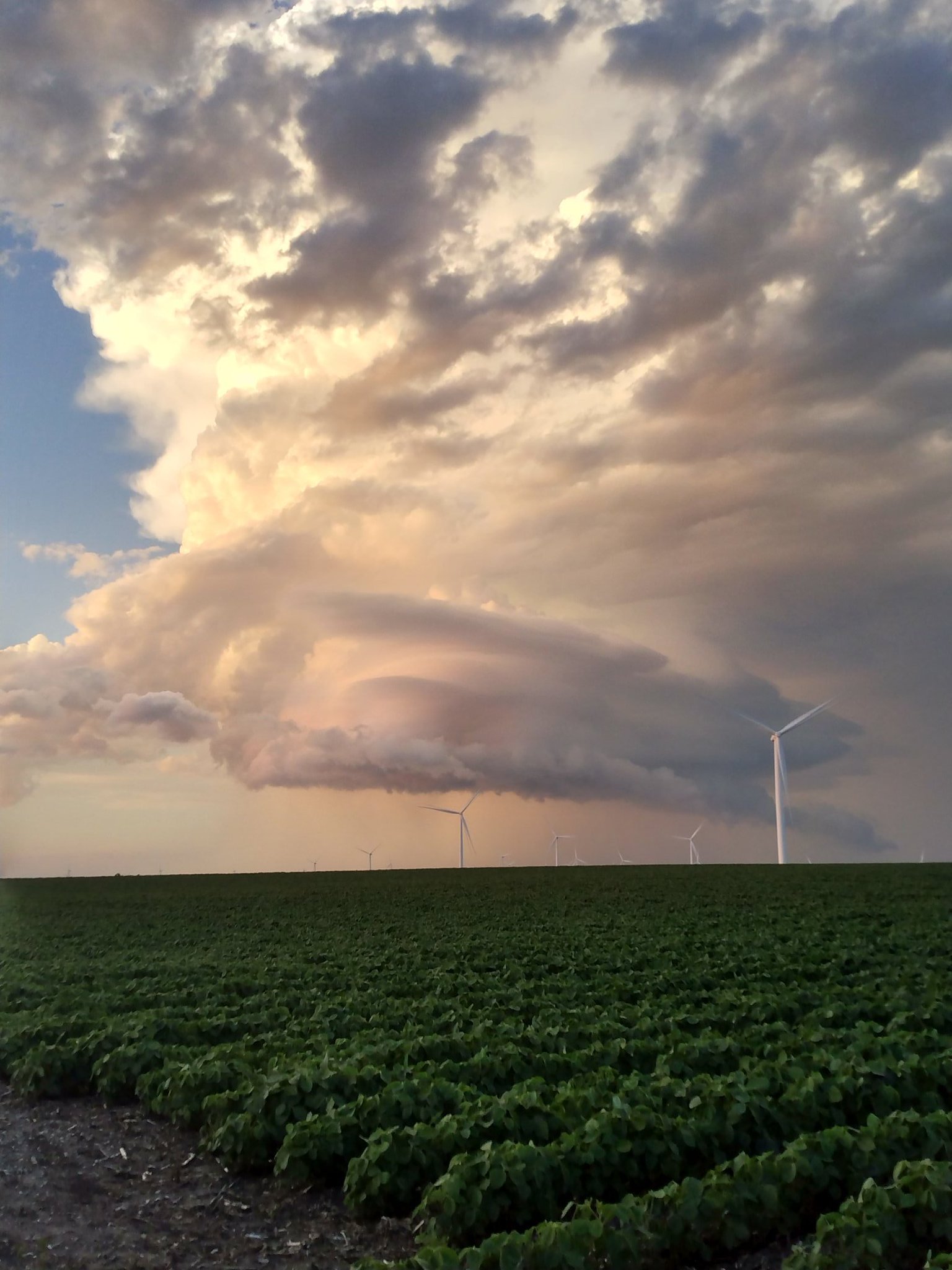
| Photo of the supercell taken from Primghar, Iowa during the evening. Photo courtesy of Tracy Whitlock. | Photo of up to 2 inch hail taken near Lake Benton, Minnesota. Photo courtesy of Darlene Lane Fish. | Photo of up to 2 inch hail which fell near the South Dakota and Minnesota border along Highway 34 west of Pipestone, Minnesota. Photo is courtesy of Kelly Jai. |
Radar
Header
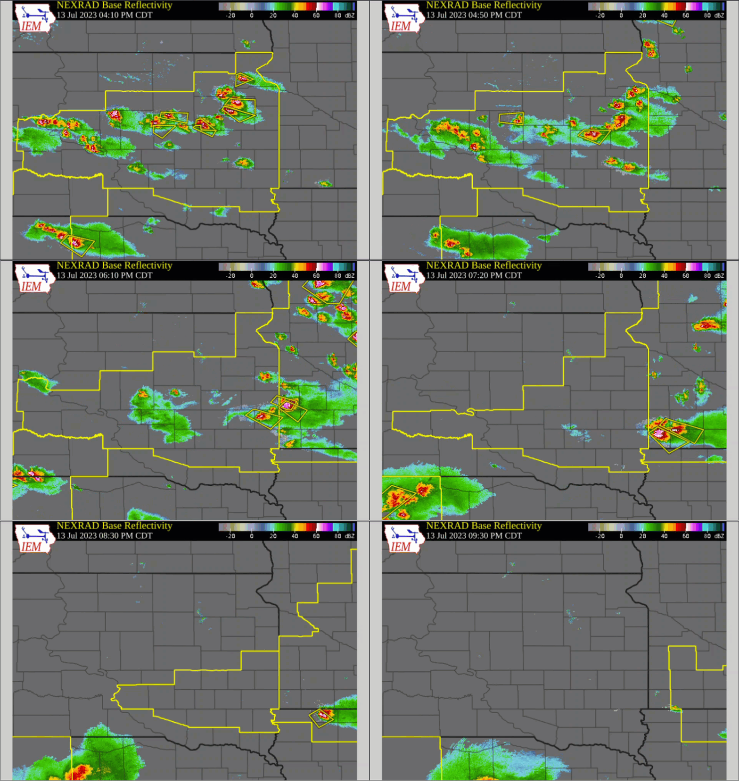 |
| Radar loop showing how storms moved across the area on the afternoon and evening of July 13, 2023. |
Storm Reports
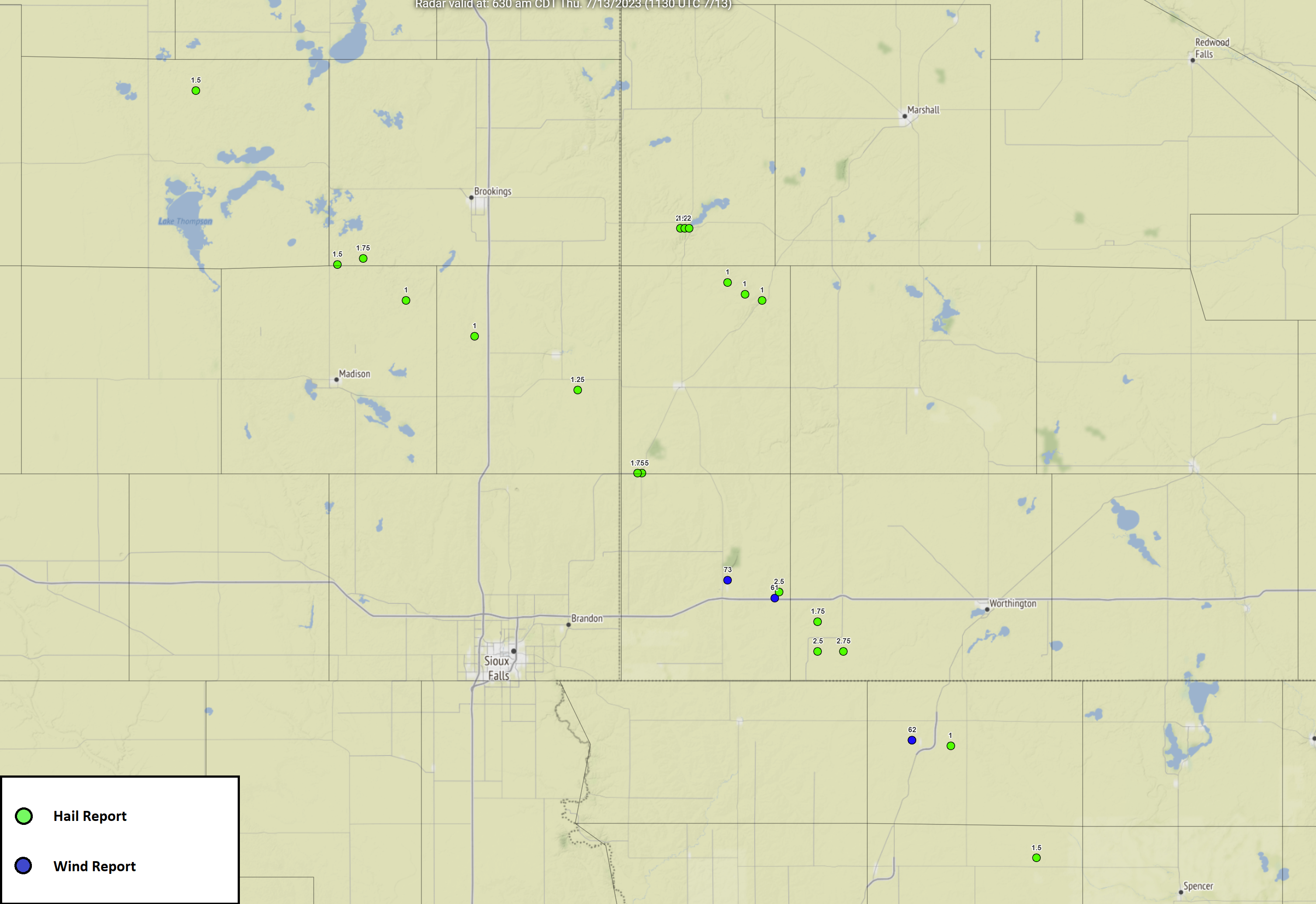
Click here for a larger version of this image.
..TIME... ...EVENT... ...CITY LOCATION... ...LAT.LON...
..DATE... ....MAG.... ..COUNTY LOCATION..ST.. ...SOURCE....
..REMARKS..
0448 PM Hail Erwin 44.49N 97.44W
07/13/2023 E1.50 inch Kingsbury SD Public
0522 PM Hail 5 SW Sinai 44.20N 97.11W
07/13/2023 M1.50 inch Brookings SD Public
Report from social media. Time estimated by
radar.
0535 PM Hail 2 S Sinai 44.21N 97.05W
07/13/2023 E1.75 inch Brookings SD Public
0549 PM Hail 4 E Nunda 44.14N 96.95W
07/13/2023 E1.00 inch Lake SD Public
Report from mPING: Quarter (1.00 in.).
0549 PM Hail 4 E Nunda 44.14N 96.95W
07/13/2023 E1.00 inch Lake SD Public
Report from mPING: Quarter (1.00 in.).
0553 PM Hail 9 S Hendricks 44.37N 96.41W
07/13/2023 E0.88 inch Lincoln MN Public
0603 PM Hail 7 N Colman 44.08N 96.79W
07/13/2023 E1.00 inch Moody SD Public
Report from mPING: Quarter (1.00 in.). Time
corrected by radar.
0608 PM Hail 4 NNW Lake Benton 44.32N 96.32W
07/13/2023 E0.88 inch Lincoln MN Trained Spotter
0609 PM Hail 7 N Colman 44.08N 96.79W
07/13/2023 E1.00 inch Moody SD Public
Report from mPING: Quarter (1.00 in.).
0611 PM Hail 1 W Lake Benton 44.26N 96.31W
07/13/2023 E2.50 inch Lincoln MN Public
Delayed report. Picture report via social
media.
0612 PM Hail Lake Benton 44.26N 96.29W
07/13/2023 M2.00 inch Lincoln MN Public
Report via social media.
0612 PM Hail Lake Benton 44.26N 96.29W
07/13/2023 M2.00 inch Lincoln MN Public
Report via social media.
0612 PM Hail Lake Benton 44.26N 96.30W
07/13/2023 E1.25 inch Lincoln MN Trained Spotter
0624 PM Hail 3 WSW Ruthton 44.15N 96.16W
07/13/2023 E1.00 inch Pipestone MN Public
Report from mPING: Quarter (1.00 in.). Time
corrected by radar.
0624 PM Hail 5 W Ruthton 44.17N 96.20W
07/13/2023 E1.00 inch Pipestone MN Trained Spotter
0626 PM Hail 3 SSW Ruthton 44.14N 96.12W
07/13/2023 E1.00 inch Pipestone MN Storm Chaser
Also 45 to 50 mph winds.
0654 PM Hail 5 SSE Flandreau 43.99N 96.55W
07/13/2023 E1.25 inch Moody SD Public
Report via social media.
0657 PM Hail Jasper 43.85N 96.40W
07/13/2023 E1.75 inch Pipestone MN Public
Report via social media. Time estimated by
radar.
0657 PM Hail Jasper 43.85N 96.41W
07/13/2023 E1.75 inch Pipestone MN Trained Spotter
0719 PM Hail Hardwick 43.78N 96.20W
07/13/2023 M0.88 inch Rock MN Trained Spotter
0734 PM Tstm Wnd Gst 1 NNE Luverne 43.67N 96.20W
07/13/2023 M73 MPH Rock MN Mesonet
Measured by personal weather station.
0735 PM Tstm Wnd Gst 1 WSW Magnolia 43.64N 96.09W
07/13/2023 M61 MPH Rock MN Mesonet
Reported by Minnesota DOT weather station.
Time corrected by radar.
0740 PM Hail Magnolia 43.65N 96.08W
07/13/2023 M2.50 inch Rock MN Trained Spotter
0750 PM Hail 2 NE Ellsworth 43.55N 95.99W
07/13/2023 E2.50 inch Nobles MN Public
Report from mPING: Tennis Ball (2.50 in.).
Report time corrected by radar.
0754 PM Hail 5 ENE Ellsworth 43.55N 95.93W
07/13/2023 M2.75 inch Nobles MN Trained Spotter
0805 PM Hail 7 E Ellsworth 43.52N 95.87W
07/13/2023 E0.88 inch Nobles MN Trained Spotter
0815 PM Hail 4 SW Adrian 43.60N 95.99W
07/13/2023 E1.75 inch Nobles MN Public
Delayed report from social media.
0820 PM Hail 1 W Sibley 43.40N 95.76W
07/13/2023 M0.88 inch Osceola IA Storm Chaser
0820 PM Tstm Wnd Gst 1 W Sibley 43.40N 95.77W
07/13/2023 M62 MPH Osceola IA Storm Chaser
Corrects previous tstm wnd gst report from 1
W Sibley.
0824 PM Tstm Wnd Gst 1 W Sibley 43.40N 95.77W
07/13/2023 M62 MPH Osceola IA Storm Chaser
.
0827 PM Hail 3 ESE Sibley 43.39N 95.68W
07/13/2023 E1.00 inch Osceola IA Public
Report from mPING: Quarter (1.00 in.). Time
corrected by radar.
0845 PM Hail 5 E Melvin 43.28N 95.51W
07/13/2023 M0.75 inch Osceola IA Trained Spotter
0852 PM Hail 1 N Hartley 43.20N 95.48W
07/13/2023 E1.50 inch O'Brien IA Broadcast Media
0901 PM Hail 4 N Moneta 43.18N 95.39W
07/13/2023 E0.50 inch Clay IA Public
Report from mPING: Half-inch (0.50 in.).
Report verified by radar.
 |
Media use of NWS Web News Stories is encouraged! Please acknowledge the NWS as the source of any news information accessed from this site. |
 |