Overview
|
Another storm in an active winter moved through portions of the northern and central Plains Friday, January 27th through Saturday the 28th. Snow began during Friday evening, and increased in coverage and intensity as the low pressure slid to the east. Snowfall was moderate to heavy at times, especially overnight into Saturday morning. Snow tapered off through the morning and afternoon Saturday. Breezy northeasterly winds created some issues with blowing and drifting snow. Heaviest snowfall amounts were focused across the South Dakota and Nebraska border into northwestern IA, where anywhere from 6 to 12 inches of snow fell. There were a few localized higher reports in south central SD. Snow amounts diminished quickly as you traveled northward, with the official measurement at the Sioux Falls airport reaching 1.7 inches. Much colder air began to filter in as snow diminished Saturday. Temperatures through the day Saturday dropped; around midnight Saturday temps were in the teens and 20s for most, falling into the single digits either side of zero by early that evening. With the breezy winds, wind chills were well below zero much of Saturday. |
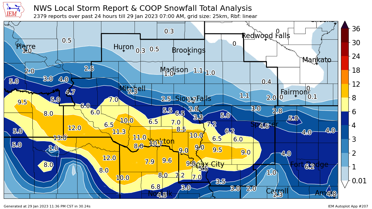 Snowfall Totals |
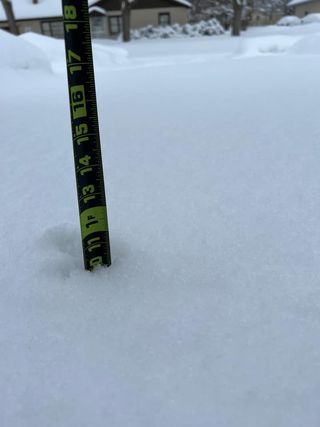
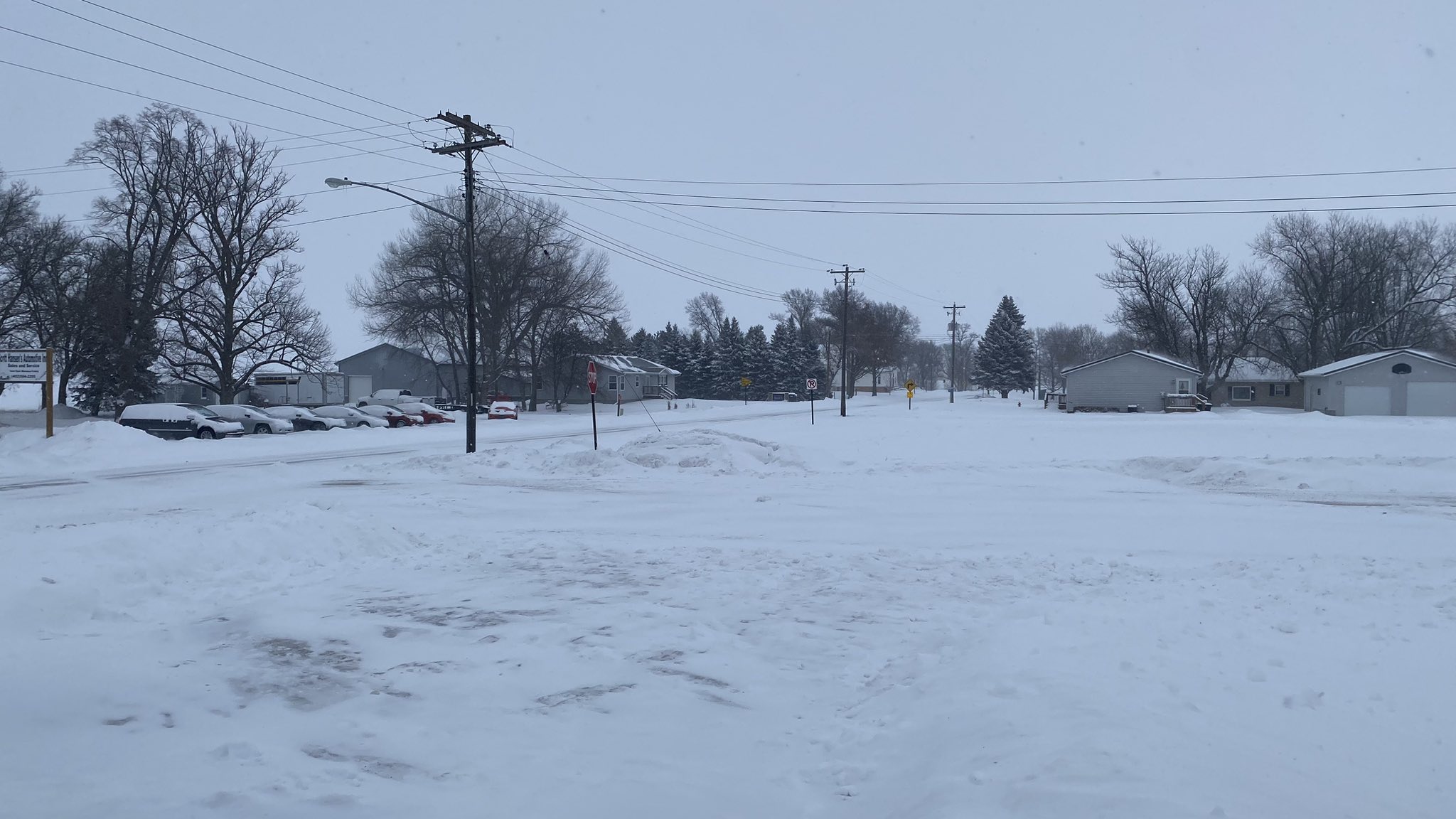
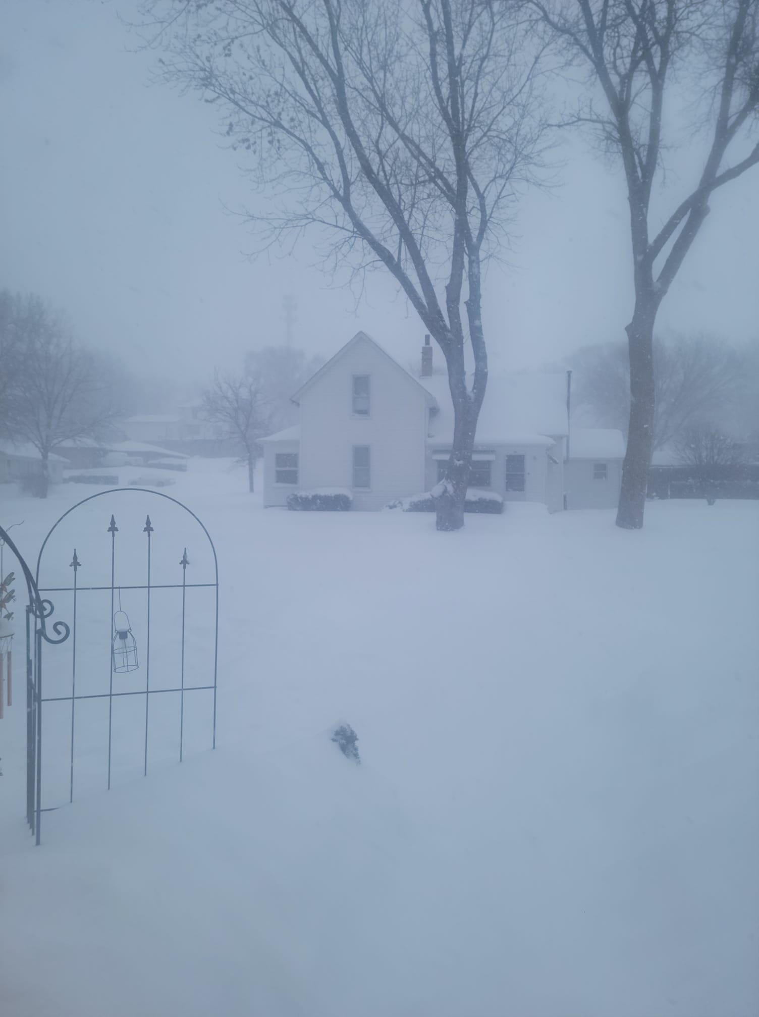
Photos & Video
Snow and measurement photos from across the region.
 |
 |
 |
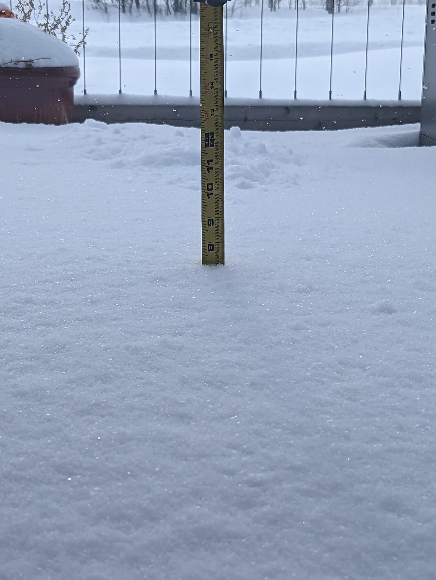 |
| Yankton, SD (Tonya Olson Ferrell) |
Concord, NE (Joe Reklaitis) |
Akron, IA (Mandy Taaggart) |
Beresford, SD (Jessica Sommervold) |
Radar
Here's a look at 30 minute radar data through the event.
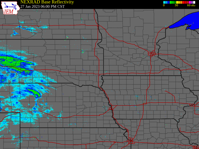 |
| Radar Loop: 6 PM Friday, Jan. 27 through 2 PM Saturday, Jan. 28 |
Storm Reports
PRELIMINARY LOCAL STORM REPORT...SUMMARY
NATIONAL WEATHER SERVICE SIOUX FALLS SD
743 AM CST SUN JAN 29 2023

..TIME...   ...EVENT...      ...CITY LOCATION...     ...LAT.LON...
..DATE...   ....MAG....      ..COUNTY LOCATION..ST.. ...SOURCE....
            ..REMARKS..

1010 PM     HEAVY SNOW       3 S BURKE               43.14N 99.29W
01/28/2023  E12.0 INCH       GREGORY            SD   PUBLIC

            REPORTED VIA SOCIAL MEDIA.

1100 AM     HEAVY SNOW       1 NW WAGNER             43.08N 98.32W
01/28/2023  M11.3 INCH       CHARLES MIX        SD   COCORAHS

            COCORAHS STATION SD-CM-14 WAGNER 0.8 NW.

1015 PM     HEAVY SNOW       6 W YANKTON             42.89N 97.51W
01/28/2023  M10.7 INCH       YANKTON            SD   PUBLIC

            REPORTED VIA SOCIAL MEDIA.

0814 PM     HEAVY SNOW       WAGNER                  43.08N 98.30W
01/28/2023  E10.5 INCH       CHARLES MIX        SD   PUBLIC

            REPORT VIA SOCIAL MEDIA.

1100 PM     HEAVY SNOW       7 SE TABOR              42.89N 97.55W
01/28/2023  E10.5 INCH       YANKTON            SD   PUBLIC

            REPORT VIA SOCIAL MEDIA.

0758 PM     HEAVY SNOW       YANKTON                 42.89N 97.39W
01/28/2023  E10.0 INCH       YANKTON            SD   PUBLIC

            REPORT VIA SOCIAL MEDIA.

0800 PM     HEAVY SNOW       4 NNW BURKE             43.23N 99.33W
01/28/2023  E10.0 INCH       GREGORY            SD   PUBLIC

            REPORT VIA SOCIAL MEDIA.

0829 PM     HEAVY SNOW       5 S WAGNER              43.01N 98.30W
01/28/2023  E10.0 INCH       CHARLES MIX        SD   PUBLIC

            REPRO VIA SOCIAL MEDIA.

0907 PM     HEAVY SNOW       ALCESTER                43.02N 96.63W
01/28/2023  E10.0 INCH       UNION              SD   PUBLIC

            REPORT VIA SOCIAL MEDIA.

1015 PM     HEAVY SNOW       1 SSE DELMONT           43.26N 98.15W
01/28/2023  E10.0 INCH       DOUGLAS            SD   PUBLIC

            REPORTED VIA SOCIAL MEDIA.

0815 PM     HEAVY SNOW       LE MARS                 42.79N 96.17W
01/28/2023  E9.5 INCH        PLYMOUTH           IA   PUBLIC

            REPORT VIA SOCIAL MEDIA.

1200 PM     HEAVY SNOW       TYNDALL                 42.99N 97.86W
01/28/2023  M9.0 INCH        BON HOMME          SD   CO-OP OBSERVER

            STORM TOTAL. CORRECTS PREVIOUS HEAVY SNOW
            REPORT FROM TYNDALL. CO-OP OBSERVER STATION
            TYNS2 TYNDALL.

0200 PM     HEAVY SNOW       REMSEN                  42.81N 95.98W
01/28/2023  M9.0 INCH        PLYMOUTH           IA   CO-OP OBSERVER

            CO-OP OBSERVER STATION RMSI4 REMSEN.

0444 PM     HEAVY SNOW       1 ESE VERMILLION        42.78N 96.91W
01/28/2023  E9.0 INCH        CLAY               SD   PUBLIC

            CORRECTS PREVIOUS SNOW REPORT FROM 1 ESE
            VERMILLION.

0648 PM     HEAVY SNOW       2 W PONCA               42.57N 96.75W
01/28/2023  M9.0 INCH        DIXON              NE   PUBLIC


0817 PM     HEAVY SNOW       AKRON                   42.83N 96.56W
01/28/2023  E9.0 INCH        PLYMOUTH           IA   PUBLIC

            REPORT VIA SOCIAL MEDIA.

0819 PM     HEAVY SNOW       CHEROKEE                42.75N 95.55W
01/28/2023  E9.0 INCH        CHEROKEE           IA   PUBLIC

            REPORT VIA SOCIAL MEDIA.

1130 PM     HEAVY SNOW       CENTERVILLE             43.12N 96.96W
01/28/2023  E8.5 INCH        TURNER             SD   PUBLIC

            REPORTED VIA SOCIAL MEDIA.

1212 PM     HEAVY SNOW       SPRINGFIELD             42.85N 97.89W
01/28/2023  E8.0 INCH        BON HOMME          SD   PUBLIC

            REPORT THROUGH NOON VIA SOCIAL MEDIA.

0829 PM     HEAVY SNOW       1 S BERESFORD           43.07N 96.78W
01/28/2023  E8.0 INCH        UNION              SD   PUBLIC


0902 PM     HEAVY SNOW       CRAIG                   42.90N 96.31W
01/28/2023  E8.0 INCH        PLYMOUTH           IA   PUBLIC

            REPORT VIA SOCIAL MEDIA.

0158 PM     HEAVY SNOW       LE MARS                 42.79N 96.17W
01/28/2023  E7.5 INCH        PLYMOUTH           IA   PUBLIC

            ESTIMATED BETWEEN 7 AND 8 INCHES. REPORT VIA
            SOCIAL MEDIA.

0823 PM     HEAVY SNOW       2 W VERMILLION          42.78N 96.97W
01/28/2023  E7.5 INCH        CLAY               SD   PUBLIC

            REPORT VIA SOCIAL MEDIA.

1215 PM     HEAVY SNOW       BERESFORD               43.08N 96.78W
01/28/2023  M7.3 INCH        UNION              SD   PUBLIC

            STORM TOTAL WITH SNOW ENDING SHORTLY AFTER
            1215 PM. REPORT VIA SOCIAL MEDIA.

1007 AM     HEAVY SNOW       CONCORD                 42.38N 96.99W
01/28/2023  M7.2 INCH        DIXON              NE   CO-OP OBSERVER

            TOTAL THROUGH 940 AM.

0239 PM     HEAVY SNOW       ROCK VALLEY             43.20N 96.30W
01/28/2023  M7.2 INCH        SIOUX              IA   PUBLIC


1030 AM     HEAVY SNOW       YANKTON                 42.89N 97.39W
01/28/2023  M7.0 INCH        YANKTON            SD   COCORAHS

            COCORAHS STATION SD-YN-23 YANKTON 0.3 ENE.

0833 PM     HEAVY SNOW       6 S ALCESTER            42.94N 96.61W
01/28/2023  E7.0 INCH        UNION              SD   PUBLIC

            REPORT VIA SOCIAL MEDIA.

0854 PM     HEAVY SNOW       STICKNEY                43.59N 98.44W
01/28/2023  E7.0 INCH        AURORA             SD   PUBLIC

            REPORT VIA SOCIAL MEDIA.

0928 PM     HEAVY SNOW       VERMILLION              42.78N 96.93W
01/28/2023  E7.0 INCH        CLAY               SD   PUBLIC

            REPORT VIA SOCIAL MEDIA.

0955 PM     HEAVY SNOW       4 S HURLEY              43.23N 97.08W
01/28/2023  E7.0 INCH        TURNER             SD   PUBLIC

            REPORTED VIA SOCIAL MEDIA.

1000 AM     HEAVY SNOW       2 N LAKE ANDES          43.19N 98.54W
01/28/2023  M6.5 INCH        CHARLES MIX        SD   COCORAHS

            MEASURED BETWEEN 6.5 AND 7 INCHES. CORRECTS
            PREVIOUS SNOW REPORT FROM 2 N LAKE ANDES.
            COCORAHS STATION SD-CM-21 LAKE ANDES 2.4 N.

0600 PM     HEAVY SNOW       MENNO                   43.24N 97.57W
01/28/2023  M6.5 INCH        HUTCHINSON         SD   CO-OP OBSERVER

            CORRECTS PREVIOUS SNOW REPORT FROM MENNO.
            CO-OP OBSERVER STATION MNOS2 MENNO.

0754 PM     HEAVY SNOW       CHANCELLOR              43.37N 96.99W
01/28/2023  E6.5 INCH        TURNER             SD   PUBLIC

            REPORT VIA SOCIAL MEDIA.

1050 PM     HEAVY SNOW       MAURICE                 42.97N 96.18W
01/28/2023  M6.5 INCH        SIOUX              IA   PUBLIC

            REPORTED VIA SOCIAL MEDIA.

0224 PM     HEAVY SNOW       1 N HOSPERS             43.09N 95.90W
01/28/2023  E6.2 INCH        SIOUX              IA   PUBLIC

            REPORT VIA SOCIAL MEDIA.

0900 AM     HEAVY SNOW       13 WNW PLATTE           43.49N 99.06W
01/28/2023  M6.0 INCH        CHARLES MIX        SD   CO-OP OBSERVER

            CO-OP OBSERVER STATION ACYS2 ACADEMY 2 NE.

1100 AM     HEAVY SNOW       2 SSE SIOUX CENTER      43.05N 96.15W
01/28/2023  M6.0 INCH        SIOUX              IA   CO-OP OBSERVER

            CO-OP OBSERVER STATION SIXI4 2.1 SE SIOUX
            CENTER.

0102 PM     HEAVY SNOW       CHEROKEE                42.75N 95.55W
01/28/2023  E6.0 INCH        CHEROKEE           IA   PUBLIC

            TOTAL THROUGH NOON. RELAYED BY BROADCAST
            MEDIA.

0940 PM     HEAVY SNOW       OLIVET                  43.24N 97.67W
01/28/2023  E6.0 INCH        HUTCHINSON         SD   PUBLIC

            REPORT VIA SOCIAL MEDIA.

0955 PM     HEAVY SNOW       2 SW PAULLINA           42.96N 95.72W
01/28/2023  E6.0 INCH        O'BRIEN            IA   PUBLIC

            REPORTED VIA SOCIAL MEDIA.

0230 PM     SNOW             ORANGE CITY             43.00N 96.06W
01/28/2023  M5.7 INCH        SIOUX              IA   PUBLIC


0430 PM     SNOW             4 SSE NORTH SIOUX CITY  42.49N 96.48W
01/28/2023  M5.5 INCH        UNION              SD   BROADCAST MEDIA


0823 PM     SNOW             MARION                  43.42N 97.26W
01/28/2023  E5.5 INCH        TURNER             SD   PUBLIC

            REPORT VIA SOCIAL MEDIA.

0921 AM     SNOW             2 ESE YANKTON           42.88N 97.36W
01/28/2023  E5.0 INCH        YANKTON            SD   BROADCAST MEDIA

            THROUGH 6 AM.

0930 AM     SNOW             DAKOTA CITY             42.42N 96.42W
01/28/2023  M5.0 INCH        DAKOTA             NE   EMERGENCY MNGR

            CORRECTS PREVIOUS SNOW REPORT FROM DAKOTA
            CITY.

0823 PM     SNOW             FREEMAN                 43.35N 97.43W
01/28/2023  E5.0 INCH        HUTCHINSON         SD   PUBLIC

            REPORT VIA SOCIAL MEDIA.

0926 PM     SNOW             4 SSE NORTH SIOUX CITY  42.48N 96.48W
01/28/2023  E5.0 INCH        UNION              SD   PUBLIC

            REPORT VIA SOCIAL MEDIA.

1225 AM     SNOW             GEORGE                  43.34N 96.00W
01/29/2023  M5.0 INCH        LYON               IA   PUBLIC

            REPORTED VIA SOCIAL MEDIA.

0751 AM     SNOW             2 S ARMOUR              43.30N 98.34W
01/28/2023  M4.8 INCH        DOUGLAS            SD   EMERGENCY MNGR


0114 PM     SNOW             1 N SPENCER             43.17N 95.15W
01/28/2023  M4.6 INCH        CLAY               IA   CO-OP OBSERVER

            TOTAL THROUGH 1245 PM.

0757 AM     SNOW             ROCK VALLEY             43.20N 96.30W
01/28/2023  M4.5 INCH        SIOUX              IA   PUBLIC


1010 AM     SNOW             3 N SIOUX CITY          42.54N 96.39W
01/28/2023  M4.5 INCH        WOODBURY           IA   BROADCAST MEDIA

            TOTAL THROUGH 945 AM.

0825 PM     SNOW             SPENCER                 43.15N 95.15W
01/28/2023  E4.5 INCH        CLAY               IA   PUBLIC

            REPORT VIA SOCIAL MEDIA.

0400 PM     SNOW             PRIMGHAR                43.09N 95.63W
01/28/2023  M4.0 INCH        O'BRIEN            IA   CO-OP OBSERVER

            CO-OP OBSERVER STATION PGHI4 PRIMGHAR.

0135 PM     SNOW             HULL                    43.19N 96.13W
01/28/2023  E3.5 INCH        SIOUX              IA   PUBLIC

            STORM TOTAL, ENDING AT NOON. REPORT VIA
            SOCIAL MEDIA.

0850 AM     SNOW             1 NNW CANTON            43.31N 96.59W
01/28/2023  M3.3 INCH        LINCOLN            SD   CO-OP OBSERVER

            CO-OP OBSERVER STATION CNNS2 CANTON.

1100 AM     SNOW             1 SSE VERMILLION        42.76N 96.92W
01/28/2023  M3.1 INCH        CLAY               SD   CO-OP OBSERVER

            CO-OP OBSERVER STATION VRMS2 1.4 S
            VERMILLION.

0800 AM     SNOW             LAKE PARK               43.45N 95.33W
01/28/2023  M3.0 INCH        DICKINSON          IA   COCORAHS

            COCORAHS STATION IA-DK-6 LAKE PARK 0.2 N.

0918 PM     SNOW             SLOAN                   42.23N 96.22W
01/28/2023  E3.0 INCH        WOODBURY           IA   PUBLIC

            REPORT VIA SOCIAL MEDIA.

1239 PM     SNOW             1 NNE HARRISBURG        43.44N 96.69W
01/28/2023  M2.8 INCH        LINCOLN            SD   PUBLIC


0829 PM     SNOW             3 NNE TEA               43.48N 96.81W
01/28/2023  E2.8 INCH        LINCOLN            SD   PUBLIC

            REPORT VIA SOCIAL MEDIA.

0800 AM     SNOW             ORANGE CITY             43.01N 96.07W
01/28/2023  M2.5 INCH        SIOUX              IA   COCORAHS

            COCORAHS STATION IA-SX-9 ORANGE CITY 0.4
            WNW.

1045 PM     SNOW             CANISTOTA               43.60N 97.29W
01/28/2023  E2.5 INCH        MCCOOK             SD   PUBLIC

            REPORTED VIA SOCIAL MEDIA.

1000 AM     SNOW             4 WSW SIOUX FALLS       43.53N 96.80W
01/28/2023  M2.1 INCH        MINNEHAHA          SD   COCORAHS

            COCORAHS STATION SD-MH-35 SIOUX FALLS 3.7
            WSW.

0807 PM     SNOW             MITCHELL                43.73N 98.03W
01/28/2023  E2.0 INCH        DAVISON            SD   PUBLIC

            REPORT VIA SOCIAL MEDIA.

0844 PM     SNOW             JACKSON                 43.62N 94.99W
01/28/2023  E2.0 INCH        JACKSON            MN   PUBLIC

            REPORT VIA SOCIAL MEDIA.

1100 AM     SNOW             4 SSE SIOUX FALLS       43.49N 96.71W
01/28/2023  M1.9 INCH        LINCOLN            SD   PUBLIC


0811 PM     SNOW             FLANDREAU               44.05N 96.59W
01/28/2023  M1.1 INCH        MOODY              SD   CO-OP OBSERVER

            REPORT VIA SOCIAL MEDIA.

0600 AM     SNOW             3 N SIOUX FALLS         43.59N 96.73W
01/29/2023  M1.7 INCH        MINNEHAHA          SD   CO-OP OBSERVER

            CO-OP OBSERVER STATION FSDS2 SIOUX FALLS
            NWS.


&&

$$
 |
Media use of NWS Web News Stories is encouraged! Please acknowledge the NWS as the source of any news information accessed from this site. |
|


 Weather Story
 Weather Map
 Local Radar