Overview
|
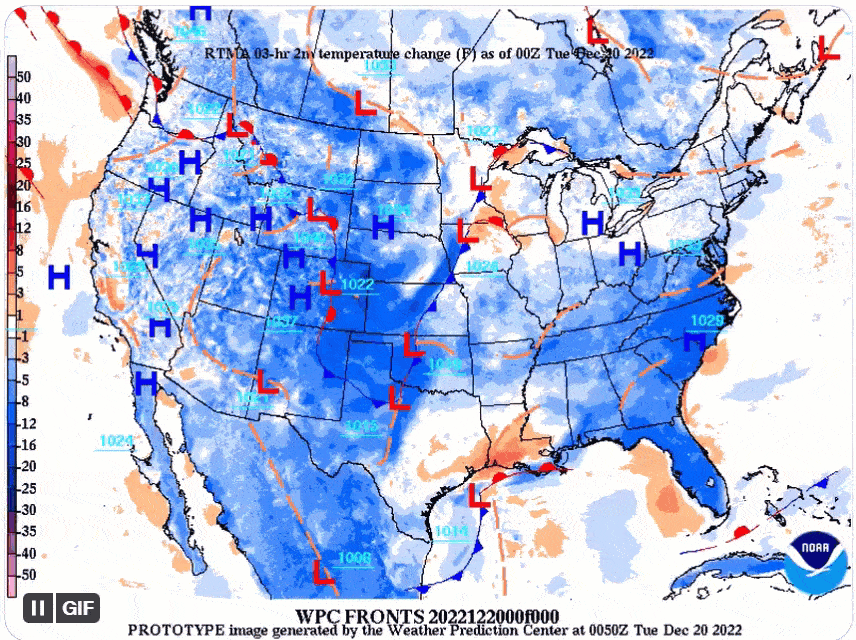
A large storm system and strong Arctic cold front brought accumulating snow, gusty northwest winds and dangerously cold wind chills to the region. This resulted in widespread ground blizzard conditions to much of the Northern Plains. Dangerously cold wind chills below -35F were also in place resulting in life-threatening travel conditions for the days leading up to Christmas. Numerous highways and interstates were closed with some travelers becoming stranded, requiring rescue. This front pushed southward through the entire southern United States, bringing multiple weather hazards and abnormally cold temperatures to the eastern 2/3rds of the CONUS. |
 Caption |
.png) |
.png) |
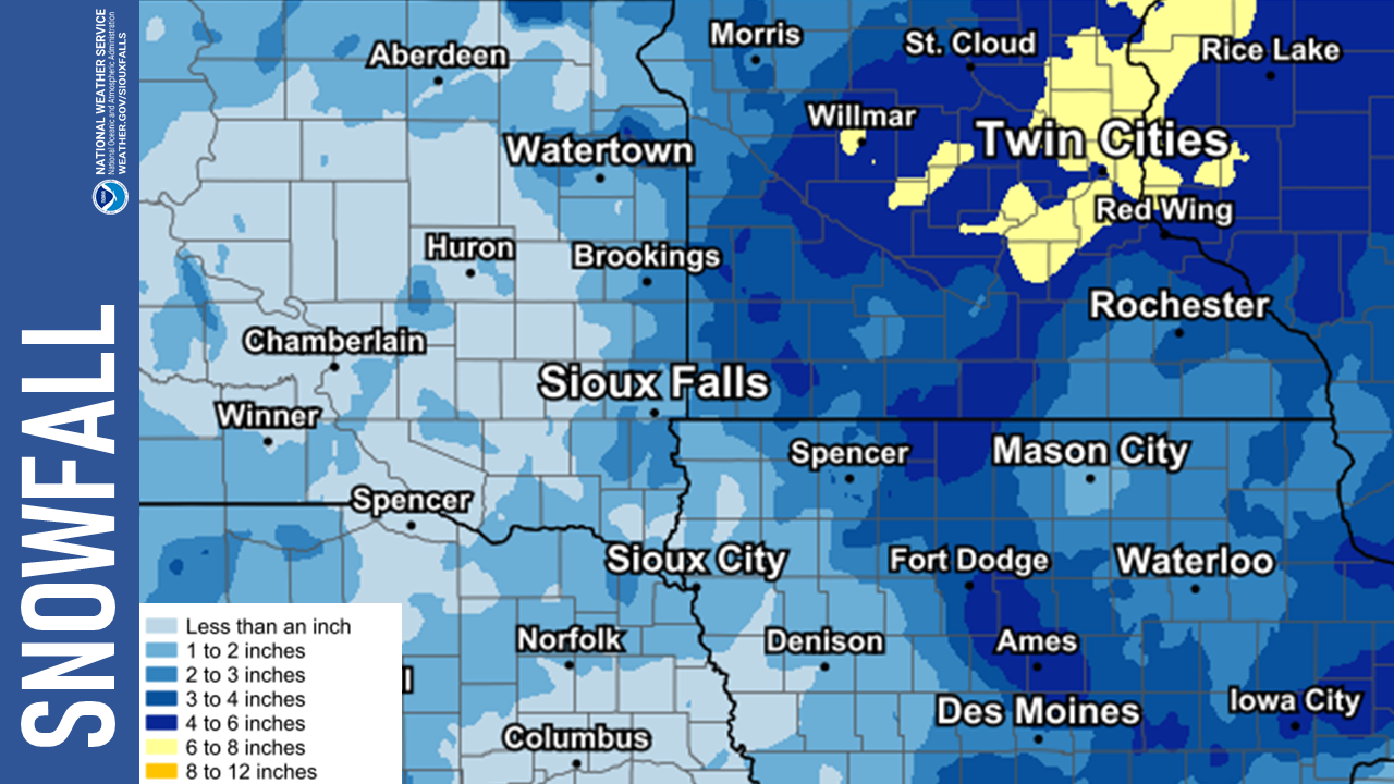 |
| Minimum Wind Chills and Timeline | Maximum Wind Gusts and Timeline | Observed Snowfall |
Wind and Wind Chill Reports
...HIGHEST WIND REPORTS FROM DECEMBER 21ST THRU 23RD...

Location                     Speed     Time/Date       Provider
SD RWIS Platte-Winner Bridge 59 MPH    0911 PM 12/22   SDDOT
SD RWIS Ft. Randall Dam      57 MPH    0422 PM 12/22   SDDOT
Sioux Gateway Airport        56 MPH    1212 PM 12/23   ASOS
Sioux County Regional Airpor 55 MPH    1235 PM 12/23   MESOWEST
Spencer Municipal Airport    54 MPH    1128 AM 12/23   ASOS
T.h.71 - Jeffers - Mp 43     54 MPH    0250 PM 12/23   MESOWEST
SD RWIS Montrose             53 MPH    0725 PM 12/22   SDDOT
Storm Lake Airport           52 MPH    0115 PM 12/23   AWOS
T.h.60 - Mountain Lake - Mp  52 MPH    0840 PM 12/23   MESOWEST
SD RWIS Beresford            51 MPH    0645 PM 12/23   SDDOT
SD RWIS Parker               51 MPH    0128 PM 12/23   SDDOT
Windom Municipal Airport     51 MPH    1235 PM 12/23   AWOS
SD RWIS Dell Rapids          50 MPH    1139 AM 12/23   SDDOT
SD RWIS Dixon                50 MPH    0305 PM 12/22   SDDOT
SD RWIS Corsica              50 MPH    0547 AM 12/23   SDDOT
SD RWIS Freeman              49 MPH    0309 PM 12/23   SDDOT
SD RWIS Davis                49 MPH    0809 PM 12/22   SDDOT
SD RWIS Alexandria           49 MPH    1108 AM 12/23   SDDOT
SD RWIS Kimball              49 MPH    0731 PM 12/22   SDDOT
TERRIL                       49 MPH    1209 PM 12/23   CWOP
SD RWIS Tripp                48 MPH    0844 PM 12/22   SDDOT
SD RWIS Lane                 48 MPH    1009 PM 12/22   SDDOT
SD RWIS Dallas               48 MPH    0820 PM 12/22   SDDOT
Huron Regional Airport       48 MPH    0506 PM 12/22   ASOS
Tracy Airport                48 MPH    0155 PM 12/23   AWOS
Lake Andes RAWS              48 MPH    0941 PM 12/22   RAWS
Storm Lake                   48 MPH    0230 PM 12/23   MESOWEST
SD RWIS Gayville             47 MPH    1208 PM 12/23   SDDOT
SD RWIS Plankinton           47 MPH    0113 AM 12/23   SDDOT
Sioux Falls Airport          47 MPH    1245 PM 12/23   ASOS
Marshall Municipal Airport   47 MPH    1228 PM 12/23   AWOS
I-90 - Rushmore - Mp 35      47 MPH    0140 PM 12/23   MESOWEST
T.h.30 - Dovray - Mp 49      47 MPH    0120 PM 12/23   MESOWEST
White Lake (SD Mesonet)      47 MPH    0225 PM 12/23   SDSMESO
SD RWIS Wolsey               46 MPH    0149 PM 12/22   SDDOT
SD RWIS North Sioux City     46 MPH    0855 PM 12/22   SDDOT
Sioux City                   46 MPH    1208 PM 12/23   CWOP
Hawarden                     46 MPH    0155 AM 12/23   CWOP
Mitchell Municipal Airport   46 MPH    0427 PM 12/22   ASOS
Worthington Airport          46 MPH    0325 PM 12/23   AWOS
Yankton Municipal Airport    46 MPH    1007 AM 12/22   AWOS
T.h.68 - Taunton - Mp 22.9   46 MPH    1215 PM 12/23   MESOWEST
SD RWIS Arlington            45 MPH    0329 PM 12/22   SDDOT
SD RWIS Forestburg           45 MPH    0309 PM 12/22   SDDOT
Flandreau 3 NNE (SD Mesonet) 45 MPH    1125 AM 12/23   SDSMESO
Luverne                      45 MPH    1115 AM 12/23   CWOP
Slayton Municipal Airport    45 MPH    1233 PM 12/23   AWOS
Madison Airport              45 MPH    0735 AM 12/23   AWOS
I-90 - Lakefield - Mp 67     45 MPH    0135 PM 12/23   MESOWEST
I-90 - Magnolia - Mp 21.6    45 MPH    0135 PM 12/23   MESOWEST
SD RWIS Cavour               44 MPH    0444 PM 12/22   SDDOT
Milford                      44 MPH    1230 PM 12/23   CWOP
Mitchell                     44 MPH    0129 PM 12/22   CWOP
Chamberlain Municipal Airpor 44 MPH    1215 PM 12/22   ASOS
Le Mars Airport              44 MPH    1235 PM 12/23   AWOS
Luverne Airport              44 MPH    0115 PM 12/23   AWOS
Sheldon Airport              44 MPH    1235 PM 12/23   AWOS
Spencer                      44 MPH    0255 PM 12/23   MESOWEST
SD RWIS Tyndall              43 MPH    0947 PM 12/22   SDDOT
SD RWIS Howard               43 MPH    0502 PM 12/22   SDDOT
Beresford 7 WSW (SD Mesonet) 42 MPH    0340 PM 12/23   SDSMESO
Concord 2E                   42 MPH    1055 PM 12/22   NE-MESO
Sioux City                   42 MPH    1225 PM 12/23   MESOWEST
Scotland                     41 MPH    1215 PM 12/23   DAVIS
Canova                       41 MPH    1200 PM 12/23   CWOP
South Sioux City             41 MPH    0415 PM 12/23   CWOP
Brookings Municipal Airport  41 MPH    0532 PM 12/23   AWOS
U.s.14 - Florence - Mp 21.2  41 MPH    1035 AM 12/23   MESOWEST
Alton                        41 MPH    0125 PM 12/23   MESOWEST
Sioux Falls 10 WSW (SD Meson 41 MPH    0225 PM 12/23   SDSMESO
Lake Park                    40 MPH    1230 PM 12/23   CWOP
Colton 2 ESE (SD Mesonet)    40 MPH    0935 PM 12/22   SDSMESO
Remsen                       40 MPH    0240 PM 12/23   DAVIS
Butte 8NNW                   40 MPH    0830 PM 12/22   CWOP
Wagner                       40 MPH    0555 AM 12/23   AWOS
Cherokee Municipal Airport   40 MPH    1255 PM 12/23   AWOS
Moville                      40 MPH    1105 PM 12/22   MESOWEST
Sibley                       40 MPH    0240 PM 12/23   MESOWEST
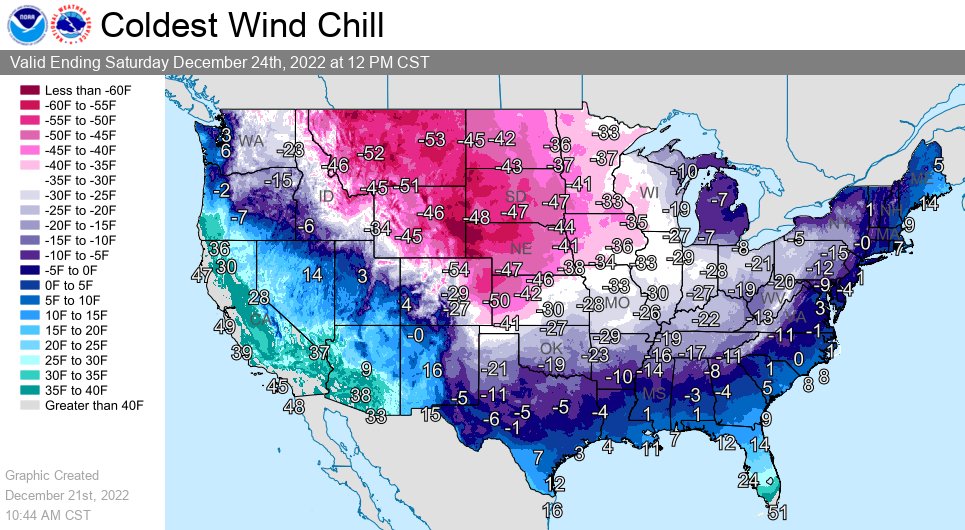
...MINIMUM WIND CHILL REPORTS FROM DECEMBER 21ST THROUGH 24TH...

Location                     WC Temp.  Time/Date       Provider

Madison Airport              -53 F     0915 AM 12/22   AWOS
White Lake (SD Mesonet)      -53 F     0445 AM 12/22   SDSMESO
SD RWIS Platte-Winner Bridge -52 F     0359 AM 12/22   SDDOT
SD RWIS Davis                -52 F     0958 AM 12/22   SDDOT
SD RWIS Alexandria           -52 F     0549 AM 12/22   SDDOT
SD RWIS Ft. Randall Dam      -52 F     0631 AM 12/22   SDDOT
SD RWIS Parker               -52 F     0844 AM 12/22   SDDOT
I-90 - Rushmore - Mp 35      -52 F     0850 AM 12/22   MESOWEST
Colton 2 ESE (SD Mesonet)    -51 F     0940 AM 12/22   SDSMESO
Scotland                     -51 F     1030 AM 12/22   DAVIS
Sioux County Regional Airpor -51 F     0955 AM 12/22   MESOWEST
I-90 - Magnolia - Mp 21.6    -51 F     0835 AM 12/22   MESOWEST
Concord 2E                   -51 F     0815 AM 12/22   NE-MESO
Sioux City                   -51 F     0800 AM 12/22   MESOWEST
Spencer                      -51 F     0910 AM 12/22   MESOWEST
Sioux Falls 10 WSW (SD Meson -51 F     0955 AM 12/22   SDSMESO
SD RWIS Gayville             -50 F     0829 AM 12/22   SDDOT
SD RWIS Howard               -50 F     0550 AM 12/22   SDDOT
SD RWIS North Sioux City     -50 F     0828 AM 12/22   SDDOT
2 N Bonesteel                -50 F     0740 AM 12/22   AWS
Beresford 7 WSW (SD Mesonet) -50 F     0755 AM 12/22   SDSMESO
Remsen                       -50 F     0700 AM 12/22   DAVIS
Flandreau 3 NNE (SD Mesonet) -50 F     1030 AM 12/22   SDSMESO
Brookings Municipal Airport  -50 F     0826 AM 12/22   AWOS
Huron Regional Airport       -50 F     0355 AM 12/22   ASOS
Mitchell Municipal Airport   -50 F     0616 AM 12/22   ASOS
Worthington Airport          -50 F     0837 AM 12/22   AWOS
Sheldon Airport              -50 F     0910 AM 12/22   AWOS
Yankton Municipal Airport    -50 F     0756 AM 12/22   AWOS
T.h.30 - Dovray - Mp 49      -50 F     0830 AM 12/22   MESOWEST
T.h.71 - Jeffers - Mp 43     -50 F     0855 AM 12/22   MESOWEST
U.s.14 - Florence - Mp 21.2  -50 F     0845 AM 12/22   MESOWEST
Lake Andes RAWS              -50 F     0541 AM 12/22   RAWS
Volga (SD Mesonet)           -50 F     0950 AM 12/22   SDSMESO
SD RWIS Cavour               -49 F     0908 AM 12/22   SDDOT
SD RWIS Forestburg           -49 F     0628 AM 12/22   SDDOT
Slayton Municipal Airport    -49 F     0933 AM 12/22   AWOS
Sioux Falls Airport          -49 F     0856 AM 12/22   ASOS
Sioux Gateway Airport        -49 F     0756 AM 12/22   ASOS
Alton                        -49 F     0850 AM 12/22   MESOWEST
SD RWIS Arlington            -48 F     0838 AM 12/22   SDDOT
SD RWIS Tyndall              -48 F     0344 AM 12/22   SDDOT
Sioux City                   -48 F     0638 AM 12/22   CWOP
Ethan                        -48 F     0835 AM 12/22   AWS
Butte 8NNW                   -48 F     0215 AM 12/22   CWOP
Luverne                      -48 F     0830 AM 12/22   CWOP
Chamberlain Municipal Airpor -48 F     0255 AM 12/22   ASOS
Luverne Airport              -48 F     1015 AM 12/22   AWOS
Storm Lake Airport           -48 F     0915 AM 12/22   AWOS
I-90 - Lakefield - Mp 67     -48 F     1030 AM 12/22   MESOWEST
T.h.60 - Mountain Lake - Mp  -48 F     0255 AM 12/23   MESOWEST
Baltic 3 SE (SD Mesonet)     -47 F     1045 AM 12/22   SDSMESO
Milford                      -47 F     1015 AM 12/22   CWOP
Canova                       -47 F     0545 AM 12/22   CWOP
TERRIL                       -47 F     1019 AM 12/22   CWOP
Marshall Municipal Airport   -47 F     1131 AM 12/22   AWOS
Tracy Airport                -47 F     0955 AM 12/22   AWOS
Vermillion                   -47 F     0655 AM 12/22   AWOS
Parkston (SD Mesonet)        -47 F     0600 AM 12/22   SDSMESO
Storm Lake                   -47 F     0915 AM 12/22   MESOWEST
Sibley                       -47 F     1145 AM 12/22   MESOWEST
6 NW Orleans                 -46 F     0905 AM 12/22   AWS
Lake Park                    -46 F     0815 AM 12/22   CWOP
Ivanhoe                      -46 F     0735 AM 12/22   CWOP
Armour                       -46 F     0900 AM 12/22   DAVIS
Canton                       -46 F     0915 AM 12/22   AWOS
Gregory                      -46 F     1155 PM 12/21   AWOS
Le Mars Airport              -46 F     0855 AM 12/22   AWOS
Windom Municipal Airport     -46 F     1215 PM 12/22   AWOS
Spencer Municipal Airport    -45 F     0953 AM 12/22   ASOS
Redstone RAWS                -45 F     0821 AM 12/22   RAWS
Moville                      -45 F     0915 AM 12/22   MESOWEST
1 S Centerville              -44 F     0950 AM 12/22   AWS
South Sioux City             -44 F     0715 AM 12/22   CWOP
Hawarden                     -44 F     0905 AM 12/22   CWOP
Mitchell                     -44 F     1158 AM 12/22   CWOP
T.h.68 - Taunton - Mp 22.9   -44 F     1050 AM 12/22   MESOWEST
Ethan                        -43 F     0230 AM 12/22   DAVIS
Spirit Lake                  -43 F     1026 AM 12/22   CWOP
Tea                          -43 F     0955 AM 12/22   AWOS
Elkton                       -42 F     0916 AM 12/22   CWOP
Wagner                       -42 F     1255 PM 12/22   AWOS
Sioux Falls (SD Mesonet)     -42 F     1015 AM 12/22   SDSMESO
Sioux Falls                  -41 F     1110 AM 12/22   CWOP
Cherokee Municipal Airport   -41 F     1015 AM 12/22   AWOS
Marshall                     -41 F     1035 AM 12/22   AWS
Wahpeton                     -41 F     1029 AM 12/22   AWS
3.2 S Correctionville (SCAN) -41 F     0800 AM 12/22   MESOWEST
Loess Hills Tnc Broken       -40 F     0811 AM 12/22   RAWS
Harrisburg                   -40 F     0345 AM 12/23   DAVIS
Hartley                      -40 F     0755 AM 12/22   DAVIS
National Impact
 |
 |
 |
 |
| Coldest Forecast Wind Chills (Weather Prediction Center) |
Temperature Forecast (Weather Prediction Center) |
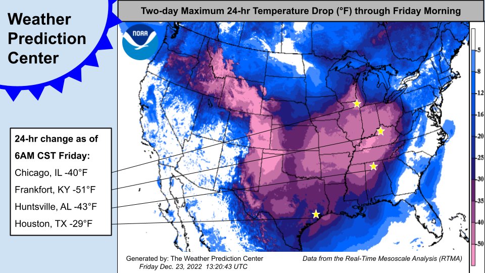
Temperature Drop (Weather Prediction Center) |
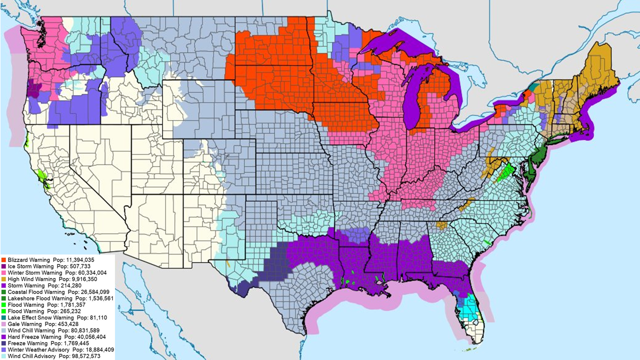
National Weather Watches/Warnings/Advisories |
Photos
 |
 |
 |
 |
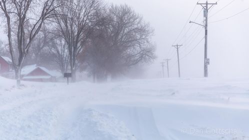
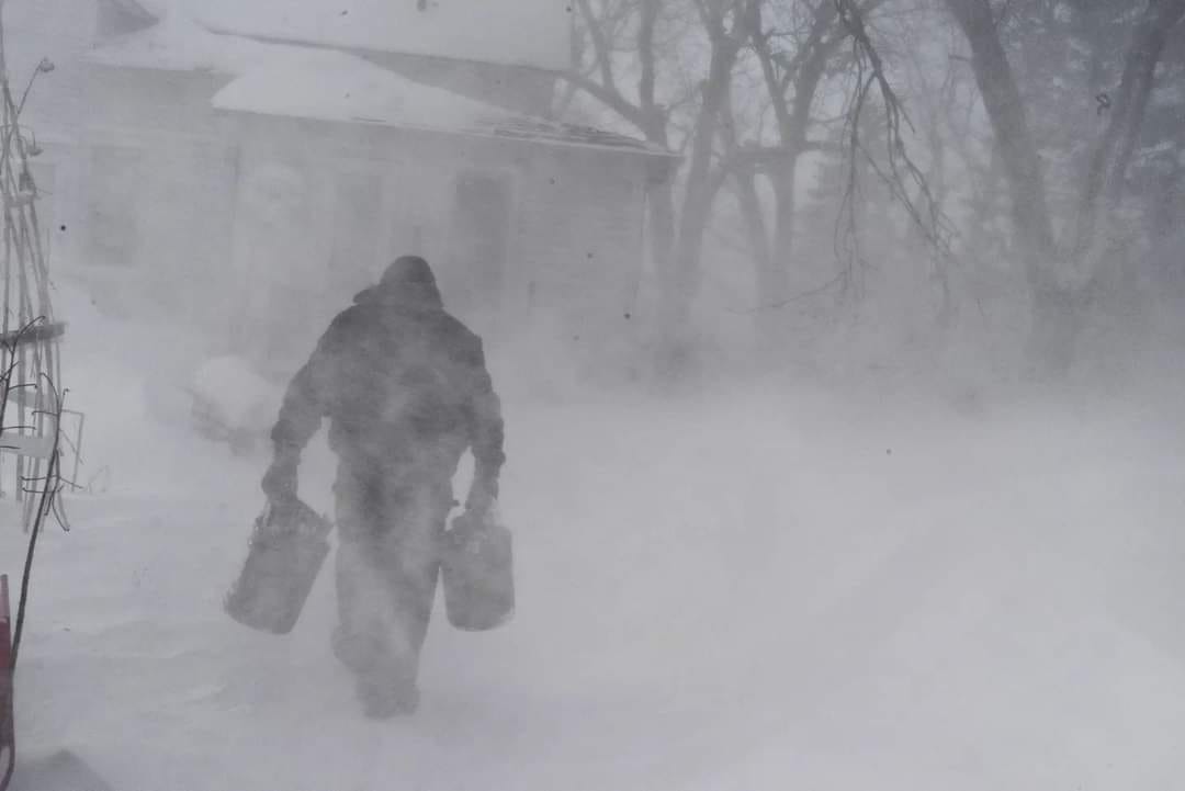
| Sanborn, IA (Dan Gottschalk) |
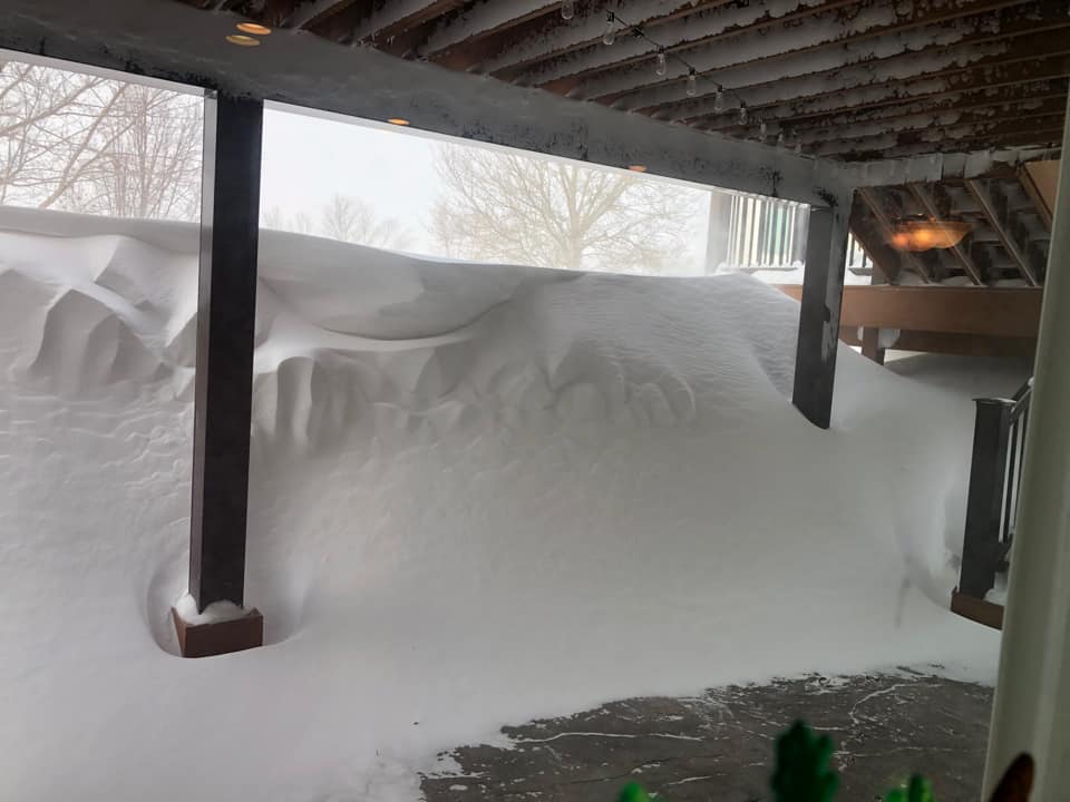
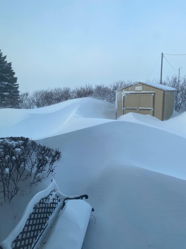
Hartford, SD (Deb Adams Johnson) |
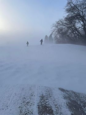
Melvin, IA (Christy Year) |
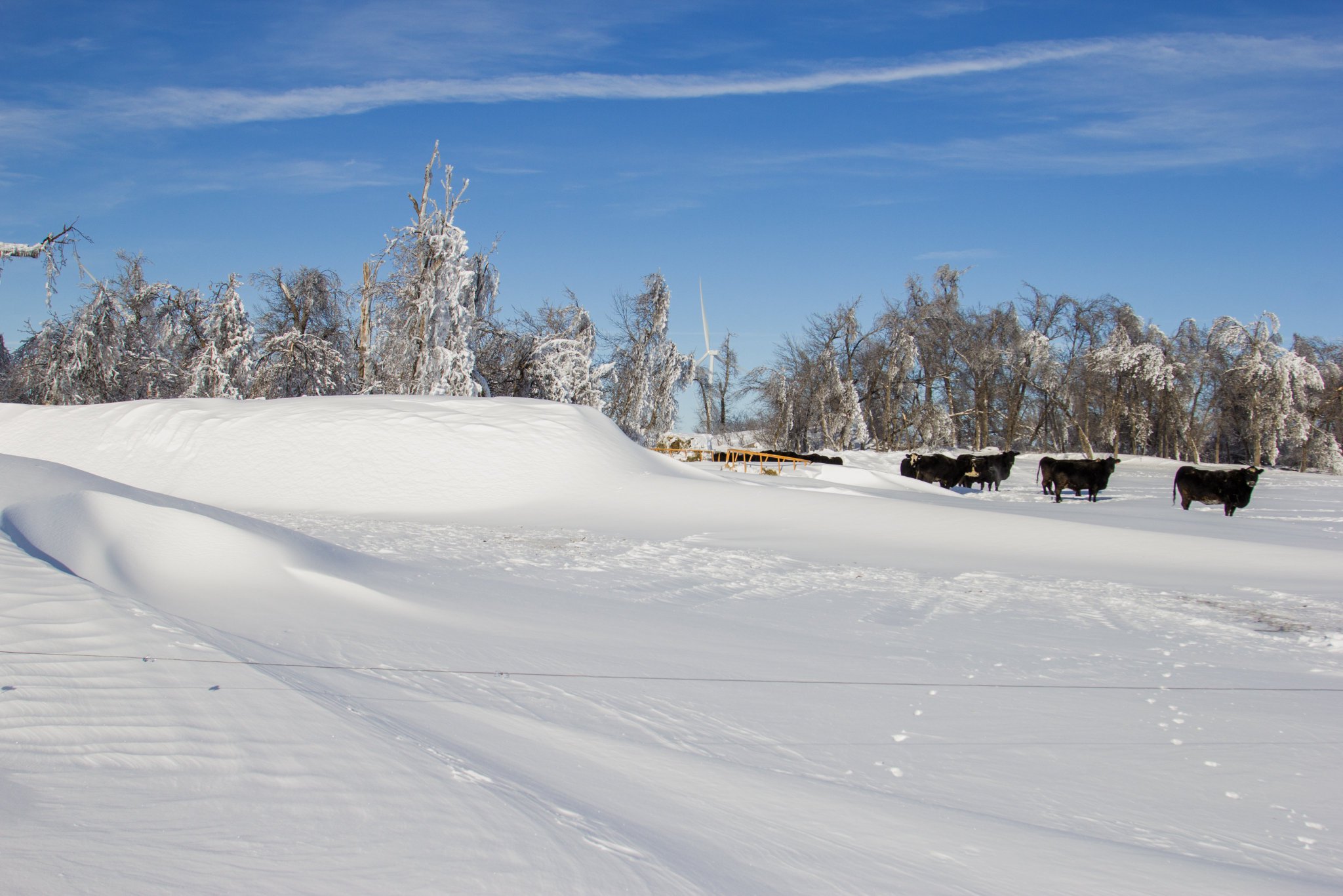
Sheldon, IA (Patty Dillon Wiarda) |
 |
 |
 |
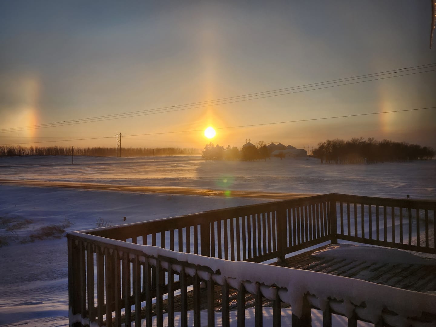 |
| Doon, IA (Mark Maassen) |
Moe, SD (Dylan Paulson) |
Ruthton, MN (Pete Bouman) |
Marshall, MN (Kaylynn Cath) |
 |
Media use of NWS Web News Stories is encouraged! Please acknowledge the NWS as the source of any news information accessed from this site. |
|


 Weather Story
 Weather Map
 Local Radar