Overview
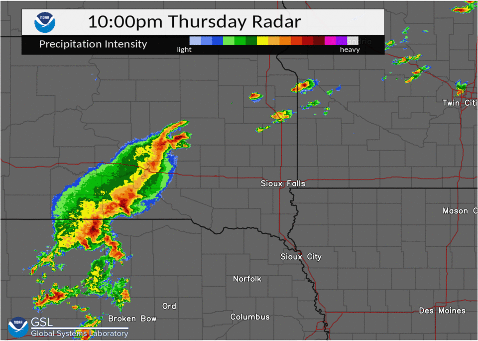
A line of severe thunderstorms developed across south central South Dakota late in the evening on September 16 and moved across southeastern South Dakota and into northwestern Iowa and southwestern Minnesota. Wind gusts of 60 to 80 mph were reported across the region. The worst damage was reported around Humboldt, South Dakota and Sheldon, Iowa.
 |
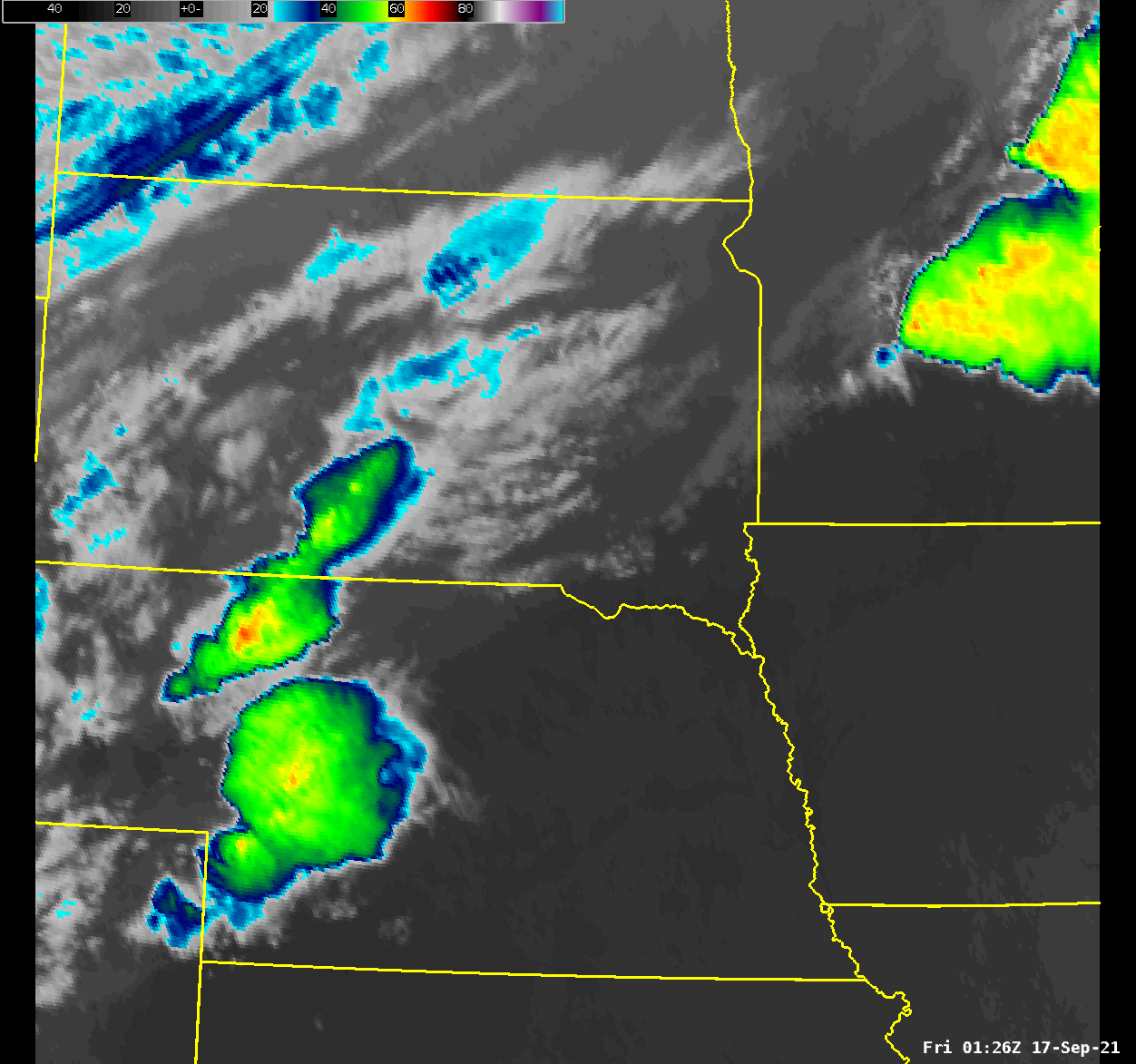 |
| Radar loop of severe thunderstorms moves across eastern South Dakota into western Minnesota and Iowa on September 16-17. | Satellite loop showing severe thunderstorms move from South Dakota into Minnesota and Iowa. The yellow and orange colors and the coldest cloud tops and where the heaviest rain would be located. |
Wind
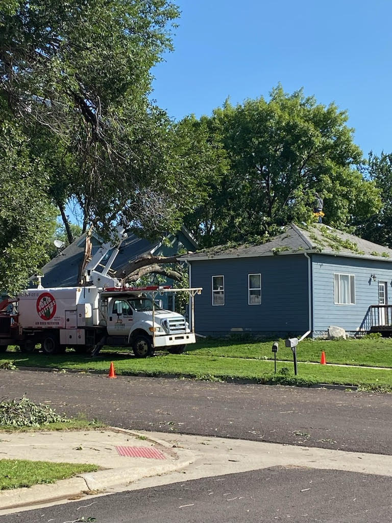
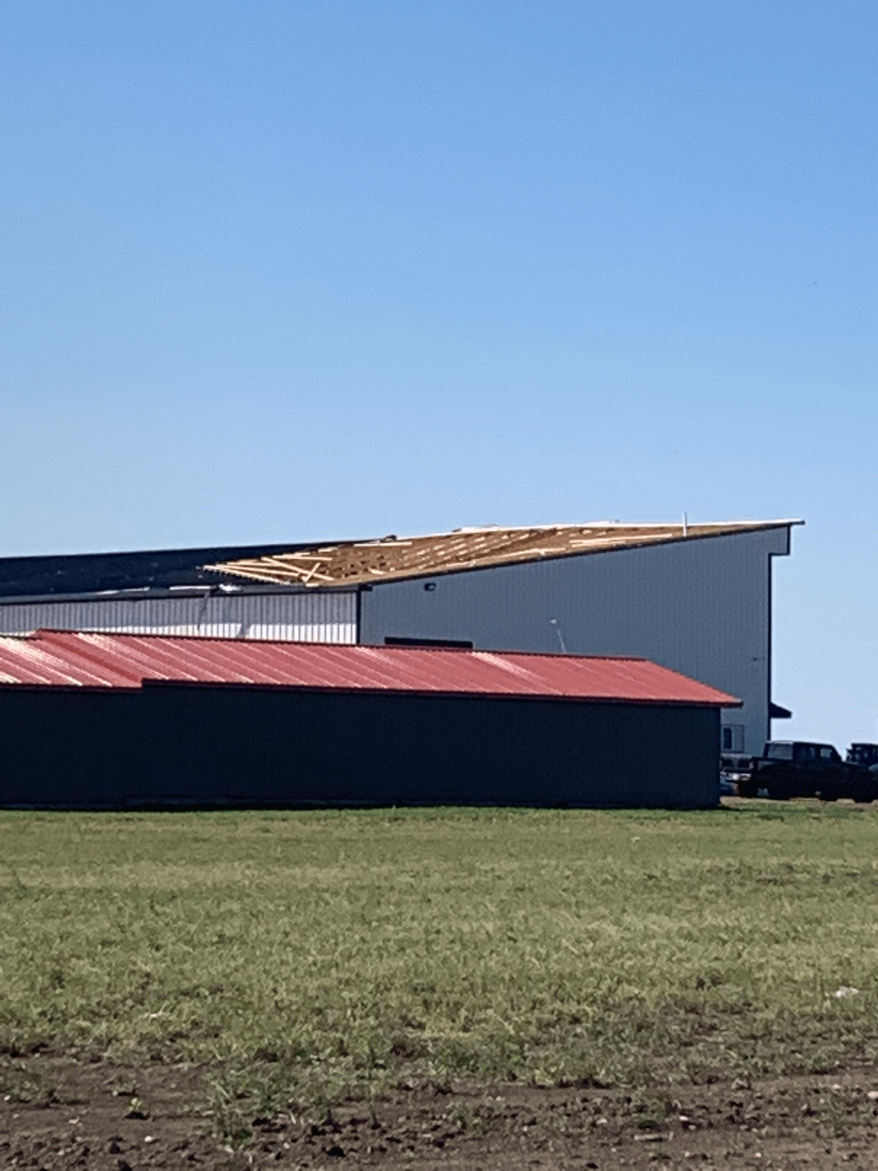
Damaging winds with gusts of 60 to 80 mph moved across portions of southeastern South Dakota into southwestern Minnesota and northwestern Iowa. The most significant damage was around Humboldt and Hartford, South Dakota - located west of Sioux Falls. Numerous trees and power lines were downed by the damaging winds. A few buildings and grain bins were also damaged by the winds. Significant damage also occurred around Sheldon, Iowa where a roof was torn off of a strip mall. There were also numerous reports of trees and large branches snapped across the area.
 |
 |
| A large tree down on a house in Humboldt. Photo is courtesy of Minnehaha County Sheriff's Department. | A grain bin was damaged in Humboldt by strong winds just before midnight. Photo is courtesy of Minnehaha Sheriff's Department. |
 |
 |
| A large tree toppled by the damaging winds has landed on a roof in Hartford, South Dakota. Photo is courtesy of the Minnehaha County Sheriff's Department | Damage to the roof of a building in Hartford, South Dakota associated with damaging winds that moved through Hartford around 12:05 AM 17 September. Photo is courtesy of the Minnehaha County Sheriff's Department. |
Radar
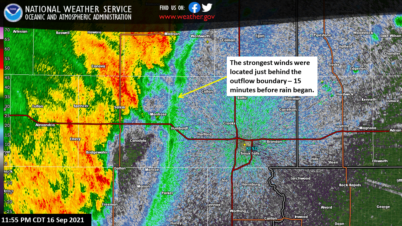 |
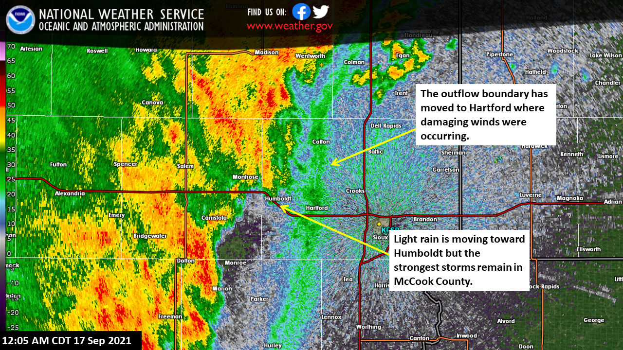 |
| The outflow boundary reached Humboldt, SD at 11:55 PM CDT. The strongest winds and damage occurred just behind this boundary. The rain did not reach Humboldt for another 15 minutes | The outflow boundary has moved into Hartford, SD at 12:05 AM CDT. Several large branches and a few trees were knocked down by the strong winds. |
Storm Reports
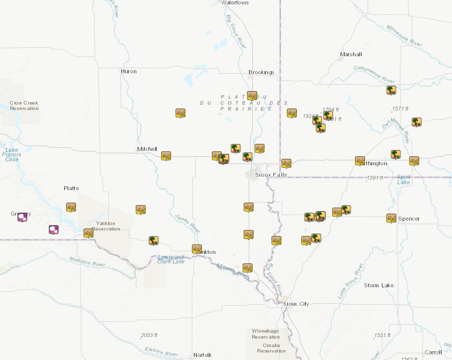
| Time and Date | County | Location | State | Type of event | Magnitude | Remarks |
| 10:27 PM 16 Sep 2021 | Gregory | Burke | SD | Hail | 0.75 in | The hail was accompanied by strong winds, but no damage. |
| 10:27 PM 16 Sep 2021 | Gregory | 4 W Herrick | SD | Hail | 1.25 in | |
| 10:48 PM 16 Sep 2021 | Gregory | Bonesteel | SD | Hail | 0.70 in | Relayed report from a deputy reporting dime sized hail. |
| 11:16 PM 16 Sep 2021 | Gregory | 2 WSW Pickstown | SD | Thunderstorm Wind Gust | 81 mph | South Dakota RWIS station 244 sd on Fort Randall Dam. |
| 11:20 PM 16 Sep 2021 | Charles Mix | 3 W Geddes | SD | Thunderstorm Wind Gust | 63 mph | RAWS station RLAS2. |
| 11:26 PM 16 Sep 2021 | Miner | 1 W Howard | SD | Thunderstorm Wind Gust | 59 mph | South Dakota RWIS station 297 at the junction of SD Hwy 35 and SD Hwy 25. |
| 11:36 PM 16 Sep 2021 | Hanson | 4 ENE Alexandria | SD | Thunderstorm Wind Gust | 64 mph | South Dakota RWIS station 213. |
| 11:36 PM 16 Sep 2021 | Hutchinson | 2 NW Tripp | SD | Thunderstorm Wind Gust | 73 mph | South Dakota RWIS station 26. |
| 11:43 PM 16 Sep 2021 | Bon Homme | 1 E Tyndall | SD | Thunderstorm Wind Damage | Unknown | Branches down in Tyndall including an 8 inch diameter branch on the east side of town. |
| 11:56 PM 16 Sep 2021 | Mccook | 3 SE Montrose | SD | Thunderstorm Wind Gust | 77 mph | South Dakota RWIS station 18. |
| 11:58 PM 16 Sep 2021 | Minnehaha | Humboldt | SD | Thunderstorm Wind Damage | Unknown | Spotter sent pictures of multiple damaged trees and blown over utility trailers. |
| 11:58 PM 16 Sep 2021 | Minnehaha | Humboldt | SD | Thunderstorm Wind Damage | Unknown | Spotter sent pictures of the elevator grain bin damage. |
| 11:58 PM 16 Sep 2021 | Minnehaha | Humboldt | SD | Thunderstorm Wind Damage | Unknown | Relayed report of high winds leading to transformers blown, with power outages being reported across the area. |
| 12:04 AM 17 Sep 2021 | Moody | 10 SSW Aurora | SD | Thunderstorm Wind Gust | 62 mph | South Dakota RWIS station 224. |
| 12:12 AM 17 Sep 2021 | Minnehaha | Crooks | SD | Thunderstorm Wind Damage | Unknown | Several rows of shingles blown off of the house and garage. A neighbor also had large tree blown down in the front yard. |
| 12:15 AM 17 Sep 2021 | Yankton | 2 NE Yankton | SD | Thunderstorm Wind Gust | 63 mph | AWOS at Yankton Municipal Airport. |
| 12:15 AM 17 Sep 2021 | Minnehaha | 3 SE Baltic | SD | Thunderstorm Wind Gust | 73 mph | SDSU mesonet station BTCS2. |
| 12:19 AM 17 Sep 2021 | Minnehaha | 4 S Colton | SD | Thunderstorm Wind Damage | Unknown | Report from mping: 1-inch tree limbs broken; shingles blown off. |
| 12:20 AM 17 Sep 2021 | Moody | 10 SSW Aurora | SD | Thunderstorm Wind Gust | 64 mph | South Dakota RWIS station 224. |
| 12:28 AM 17 Sep 2021 | Union | 3 SSW Beresford | SD | Thunderstorm Wind Gust | 63 mph | South Dakota RWIS station 16. |
| 12:30 AM 17 Sep 2021 | Pipestone | 1 NNW Pipestone | MN | Thunderstorm Wind Gust | 60 mph | RAWS station RPPM5 (Redstone). |
| 12:37 AM 17 Sep 2021 | Rock | 1 WSW Beaver Creek | MN | Thunderstorm Wind Gust | 59 mph | Minneosta RWIS station MN006. |
| 12:38 AM 17 Sep 2021 | Clay | 6 E Vermillion | SD | Thunderstorm Wind Gust | 71 mph | Measured by a personal weather station. |
| 12:39 AM 17 Sep 2021 | Lincoln | 5 SSW Worthing | SD | Thunderstorm Wind Gust | 58 mph | South Dakota RWIS station 176. |
| 12:39 AM 17 Sep 2021 | Union | 3 SSW Beresford | SD | Thunderstorm Wind Gust | 63 mph | South Dakota RWIS station 16. |
| 12:47 AM 17 Sep 2021 | Murray | 5 SSE Woodstock | MN | Thunderstorm Wind Damage | Unknown | Uprooted and snapped trees. |
| 12:48 AM 17 Sep 2021 | Murray | 4 SW Chandler | MN | Thunderstorm Wind Damage | Unknown | A hoop barn was destroyed. The doors are missing on machine shed and roof ripped off. |
| 12:50 AM 17 Sep 2021 | Sioux | 1 SSW Hawarden | IA | Thunderstorm Wind Gust | 63 mph | Mesonet station FW6302. |
| 12:52 AM 17 Sep 2021 | Murray | 2 E Lake Wilson | MN | Thunderstorm Wind Damage | Unknown | A hoop barn was damaged. |
| 1:07 AM 17 Sep 2021 | Sioux | 2 NE Maurice | IA | Thunderstorm Wind Gust | 63 mph | AWOS at Sioux County Airport. |
| 1:20 AM 17 Sep 2021 | Cottonwood | 9 N Jeffers | MN | Thunderstorm Wind Damage | Unknown | Crops were blown over. |
| 1:20 AM 17 Sep 2021 | Nobles | 2 ENE Worthington | MN | Thunderstorm Wind Gust | 52 mph | AWOS observations from Worthington Airport. |
| 1:26 AM 17 Sep 2021 | O'Brien | 3 NNE Sheldon | IA | Thunderstorm Wind Gust | 64 mph | AWOS observation from Sheldon Airport. |
| 1:33 AM 17 Sep 2021 | Sioux | 1 SW Boyden | IA | Thunderstorm Wind Damage | Unknown | Power lines down. |
| 1:33 AM 17 Sep 2021 | Sioux | Hull | IA | Thunderstorm Wind Damage | Unknown | A large construction shed was lifted and collapsed in a nearby corn field. |
| 1:34 AM 17 Sep 2021 | Sioux | Boyden | IA | Thunderstorm Wind Damage | Unknown | A school bus garage was heavily damaged. |
| 1:34 AM 17 Sep 2021 | Sioux | Boyden | IA | Thunderstorm Wind Damage | Unknown | Large tree branches down. |
| 1:40 AM 17 Sep 2021 | Jackson | Lakefield | MN | Thunderstorm Wind Damage | Unknown | Trees down from damaging winds. |
| 1:45 AM 17 Sep 2021 | O'Brien | 5 NW Sanborn | IA | Thunderstorm Wind Damage | Unknown | Large tree limbs down. |
| 1:47 AM 17 Sep 2021 | Cottonwood | Mountain Lake | MN | Thunderstorm Wind Damage | Unknown | Several 3-4 inch diameter branches downed. |
| 1:53 AM 17 Sep 2021 | Jackson | 1 ENE Jackson | MN | Thunderstorm Wind Gust | 51 mph | AWOS station at Jackson Airport. |
| 2:04 AM 17 Sep 2021 | Clay | 4 WNW Spencer | IA | Thunderstorm Wind Gust | 54 mph | ASOS station at Spencer Municipal Airport. |
 |
Media use of NWS Web News Stories is encouraged! Please acknowledge the NWS as the source of any news information accessed from this site. |
|


 Weather Story
 Weather Map
 Local Radar