Overview
|
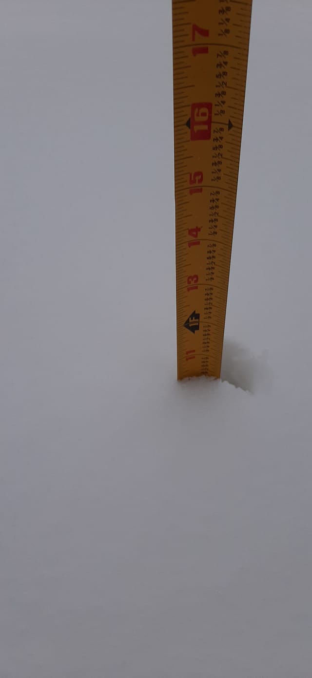
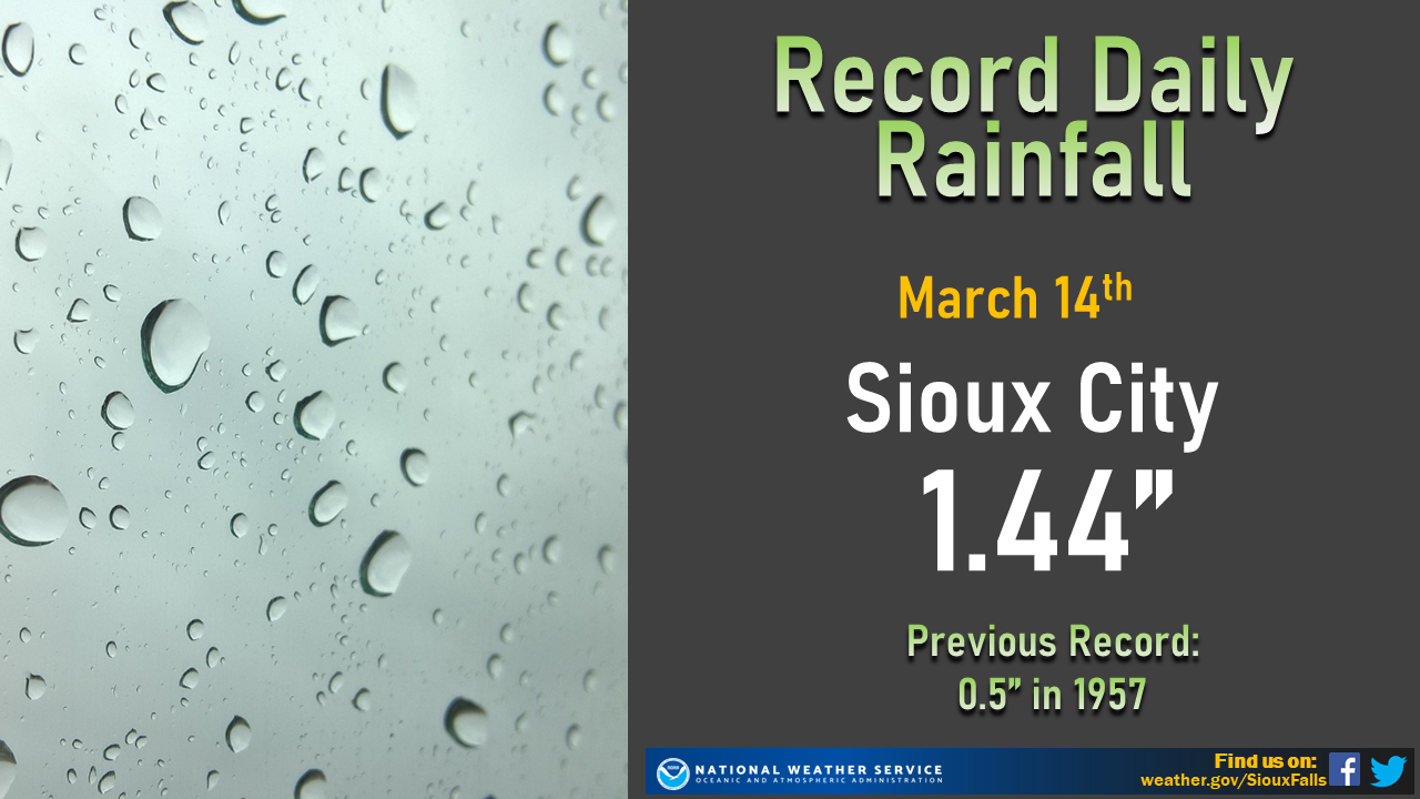
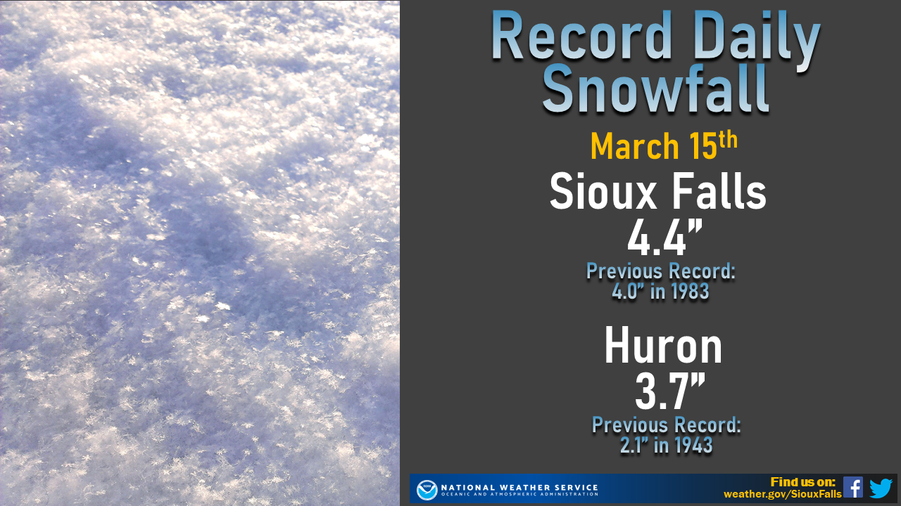
A large winter storm brought rain and dense, wet snow to the region Sunday March 14th through Monday March 15. The same system brought significant snowfall to the front range of the Rocky Mountains and severe weather to the Southern Plains. Precipitation started off as rain for many areas March 14th before gradually changing over to all snow by that night and then ending the morning of March 15th. Snow was heavy at times with snowfall rates between 1-2 inches observed in many areas. A daily record for rainfall was set at Sioux City and daily snowfall records were set at Sioux Falls and Huron during this event. |
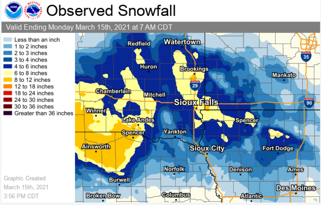 Storm Total Snowfall From March 14-15th |
Snow/Ice
..TIME... ...EVENT... ...CITY LOCATION... ...LAT.LON...
..DATE... ....MAG.... ..COUNTY LOCATION..ST.. ...SOURCE....
..REMARKS..
0630 AM SNOW 2 ESE YANKTON 42.88N 97.36W
03/15/2021 M2.0 INCH YANKTON SD CO-OP OBSERVER
CO-OP OBSERVER STATION YTNS2 YANKTON 2 E.
0447 AM SNOW 2 SSE NORTH SIOUX CITY 42.50N 96.49W
03/15/2021 M1.2 INCH UNION SD BROADCAST MEDIA
STORM TOTAL.
0900 AM SNOW 6 NNE ELK POINT 42.76N 96.65W
03/15/2021 M3.5 INCH UNION SD COCORAHS
COCORAHS STATION SD-UN-2 ELK POINT 5.6 NNE.
0600 AM SNOW HURLEY 43.28N 97.09W
03/15/2021 M4.5 INCH TURNER SD COCORAHS
COCORAHS STATION SD-TR-9 HURLEY 0.2 S.
0800 AM SNOW 4 W MONROE 43.49N 97.29W
03/15/2021 M3.5 INCH TURNER SD COCORAHS
COCORAHS STATION SD-TR-14 MARION 4.8 NNW.
0800 AM SNOW WOONSOCKET 44.05N 98.28W
03/15/2021 M4.8 INCH SANBORN SD COCORAHS
COCORAHS STATION SD-SB-3 WOONSOCKET 0.2 WSW.
0730 AM SNOW FLANDREAU 44.05N 96.60W
03/15/2021 M6.2 INCH MOODY SD CO-OP OBSERVER
CO-OP OBSERVER STATION FLAS2 FLANDREAU.
0900 AM SNOW 11 N COLMAN 44.14N 96.80W
03/15/2021 M7.0 INCH MOODY SD COCORAHS
COCORAHS STATION SD-MY-11 COLMAN 10.6 N.
0600 AM SNOW 3 N SIOUX FALLS 43.59N 96.73W
03/15/2021 M6.0 INCH MINNEHAHA SD CO-OP OBSERVER
CO-OP OBSERVER STATION FSDS2 SIOUX FALLS
NWS.
0700 AM SNOW 3 ESE SIOUX FALLS 43.53N 96.67W
03/15/2021 M7.3 INCH MINNEHAHA SD COCORAHS
COCORAHS STATION SD-MH-20 SIOUX FALLS 3.4
ESE.
0700 AM SNOW 4 WNW ROWENA 43.55N 96.63W
03/15/2021 M6.5 INCH MINNEHAHA SD COCORAHS
COCORAHS STATION SD-MH-82 SIOUX FALLS 5.2 E.
0700 AM SNOW 3 NE CROOKS 43.69N 96.78W
03/15/2021 M7.5 INCH MINNEHAHA SD COCORAHS
COCORAHS STATION SD-MH-71 RENNER 4.1 NW.
0700 AM SNOW 3 ESE SIOUX FALLS 43.52N 96.67W
03/15/2021 M6.4 INCH MINNEHAHA SD COCORAHS
COCORAHS STATION SD-MH-1 SIOUX FALLS 5.0 SE
ARPT.
0800 AM SNOW 1 ENE WALL LAKE 43.53N 96.95W
03/15/2021 M4.5 INCH MINNEHAHA SD COCORAHS
COCORAHS STATION SD-MH-8 HARTFORD 6.4 S.
0816 AM HEAVY SNOW BRANDON 43.60N 96.58W
03/15/2021 E7.0 INCH MINNEHAHA SD PUBLIC
PUBLIC REPORT FROM SOCIAL MEDIA.
1100 AM SNOW 4 WSW SIOUX FALLS 43.53N 96.80W
03/15/2021 M6.1 INCH MINNEHAHA SD COCORAHS
COCORAHS STATION SD-MH-35 SIOUX FALLS 3.7
WSW.
0100 PM HEAVY SNOW 3 N SIOUX FALLS 43.59N 96.73W
03/15/2021 M6.2 INCH MINNEHAHA SD OFFICIAL NWS OBS
STORM TOTAL SNOWFALL.
0630 AM SNOW HOWARD 44.01N 97.53W
03/15/2021 M3.7 INCH MINER SD CO-OP OBSERVER
CO-OP OBSERVER STATION HOWS2 HOWARD.
0818 AM HEAVY SNOW HOWARD 44.02N 97.52W
03/15/2021 E6.0 INCH MINER SD PUBLIC
PUBLIC REPORT FROM SOCIAL MEDIA.
0700 AM SNOW 6 NW MONTROSE 43.77N 97.25W
03/15/2021 M5.0 INCH MCCOOK SD COCORAHS
COCORAHS STATION SD-MC-1 MONTROSE 5.8 NW.
0700 AM SNOW 1 NNW CANTON 43.31N 96.59W
03/15/2021 M6.0 INCH LINCOLN SD CO-OP OBSERVER
CO-OP OBSERVER STATION CNNS2 CANTON.
0815 AM HEAVY SNOW 4 SE SIOUX FALLS 43.50N 96.69W
03/15/2021 E6.0 INCH LINCOLN SD PUBLIC
PUBLIC REPORT FROM SOCIAL MEDIA.
0817 AM HEAVY SNOW 1 SE TEA 43.44N 96.82W
03/15/2021 E7.5 INCH LINCOLN SD PUBLIC
PUBLIC REPORT FROM SOCIAL MEDIA.
0900 AM SNOW 3 SSE SIOUX FALLS 43.50N 96.70W
03/15/2021 M5.1 INCH LINCOLN SD COCORAHS
COCORAHS STATION SD-LN-1 SIOUX FALLS 4.0
SSE.
0700 AM SNOW 2 N CHESTER 43.93N 96.93W
03/15/2021 M7.2 INCH LAKE SD CO-OP OBSERVER
CO-OP OBSERVER STATION CHES2 2.4 N CHESTER.
0700 AM SNOW MADISON 44.01N 97.11W
03/15/2021 M6.8 INCH LAKE SD COCORAHS
COCORAHS STATION SD-LK-9 MADISON 0.2 NW.
0800 AM SNOW MADISON 44.01N 97.11W
03/15/2021 M8.5 INCH LAKE SD COCORAHS
COCORAHS STATION SD-LK-8 MADISON 0.3 NW.
0812 AM HEAVY SNOW MADISON 44.01N 97.11W
03/15/2021 E8.5 INCH LAKE SD PUBLIC
PUBLIC REPORT FROM SOCIAL MEDIA.
0900 AM SNOW 1 SSE MADISON 43.99N 97.09W
03/15/2021 M6.2 INCH LAKE SD CO-OP OBSERVER
CO-OP OBSERVER STATION MRFS2 MADISON 2SE.
0700 AM SNOW DE SMET 44.38N 97.55W
03/15/2021 M5.8 INCH KINGSBURY SD COCORAHS
COCORAHS STATION SD-KY-5 DE SMET 0.2 SSE.
0600 AM SNOW CLAYTON 43.45N 97.66W
03/15/2021 M1.0 INCH HUTCHINSON SD COCORAHS
COCORAHS STATION SD-HT-16 EMERY 10.8 S.
0700 AM SNOW 6 SSW HERRICK 43.04N 99.23W
03/15/2021 M11.0 INCH GREGORY SD COCORAHS
COCORAHS STATION SD-GY-18 BURKE 10.5 SSE.
0700 AM SNOW 4 SSW PICKSTOWN 43.02N 98.56W
03/15/2021 M9.0 INCH GREGORY SD CO-OP OBSERVER
CO-OP OBSERVER STATION PCKS2 PICKSTOWN 4
SSW.
0700 AM SNOW 9 S DALLAS 43.11N 99.50W
03/15/2021 M8.0 INCH GREGORY SD COCORAHS
COCORAHS STATION SD-GY-1 DALLAS 8.8 S.
0700 AM SNOW 4 SW BURKE 43.14N 99.35W
03/15/2021 M5.7 INCH GREGORY SD COCORAHS
COCORAHS STATION SD-GY-15 BURKE 4.2 SW.
0800 AM SNOW BONESTEEL 43.08N 98.95W
03/15/2021 M10.5 INCH GREGORY SD COCORAHS
COCORAHS STATION SD-GY-21 BONESTEEL 0.1 S.
0700 AM SNOW 5 W ARMOUR 43.33N 98.44W
03/15/2021 M6.0 INCH DOUGLAS SD COCORAHS
COCORAHS STATION SD-DG-2 ARMOUR 4.6 W.
0700 AM SNOW 10 W DIMOCK 43.50N 98.19W
03/15/2021 M9.0 INCH DOUGLAS SD COCORAHS
COCORAHS STATION SD-DG-1 DIMOCK 10.2 W.
0811 AM SNOW 2 S ARMOUR 43.30N 98.34W
03/15/2021 M5.5 INCH DOUGLAS SD EMERGENCY MNGR
STILL LIGHTLY SNOWING.
0700 AM SNOW 1 SSE MITCHELL 43.72N 98.03W
03/15/2021 M6.1 INCH DAVISON SD COCORAHS
COCORAHS STATION SD-DV-31 MITCHELL 0.9 SSE.
0700 AM SNOW 6 NNW ETHAN 43.63N 98.01W
03/15/2021 M6.6 INCH DAVISON SD COCORAHS
COCORAHS STATION SD-DV-28 MITCHELL 7.3 S.
0827 AM HEAVY SNOW MITCHELL 43.74N 98.03W
03/15/2021 M7.0 INCH DAVISON SD PUBLIC
PUBLIC REPORT FROM SOCIAL MEDIA.
0600 AM SNOW 1 SE VERMILLION 42.77N 96.91W
03/15/2021 M2.3 INCH CLAY SD COCORAHS
COCORAHS STATION SD-CY-10 VERMILLION 1.4 SE.
0700 AM SNOW 1 NW WAGNER 43.08N 98.32W
03/15/2021 M5.3 INCH CHARLES MIX SD COCORAHS
COCORAHS STATION SD-CM-14 WAGNER 0.8 NW.
0900 AM SNOW 13 WNW PLATTE 43.49N 99.06W
03/15/2021 M6.0 INCH CHARLES MIX SD CO-OP OBSERVER
CO-OP OBSERVER STATION ACYS2 ACADEMY 2 NE.
0530 AM SNOW CHAMBERLAIN 43.81N 99.33W
03/15/2021 M4.0 INCH BRULE SD COCORAHS
COCORAHS STATION SD-BL-1 CHAMBERLAIN 0.3 W.
0700 AM SNOW 2 S PUKWANA 43.75N 99.18W
03/15/2021 M6.5 INCH BRULE SD COCORAHS
COCORAHS STATION SD-BL-11 PUKWANA 1.9 S.
0700 AM SNOW 7 NNE CHAMBERLAIN 43.90N 99.25W
03/15/2021 M4.5 INCH BRULE SD COCORAHS
COCORAHS STATION SD-BL-13 CHAMBERLAIN 7.5
NNE.
0430 AM SNOW VOLGA 44.32N 96.92W
03/15/2021 M6.3 INCH BROOKINGS SD COCORAHS
COCORAHS STATION SD-BK-48 VOLGA 0.1 S.
0700 AM SNOW BROOKINGS 44.30N 96.79W
03/15/2021 M7.0 INCH BROOKINGS SD COCORAHS
COCORAHS STATION SD-BK-7 BROOKINGS 0.2 SSW.
0700 AM SNOW 1 S BROOKINGS 44.29N 96.79W
03/15/2021 M7.0 INCH BROOKINGS SD COCORAHS
COCORAHS STATION SD-BK-43 BROOKINGS 1.0 S.
0728 AM SNOW 2 S VOLGA 44.30N 96.92W
03/15/2021 E7.0 INCH BROOKINGS SD PUBLIC
PUBLIC REPORT FROM SOCIAL MEDIA.
0800 AM SNOW 1 SW BROOKINGS 44.29N 96.80W
03/15/2021 M8.0 INCH BROOKINGS SD COCORAHS
COCORAHS STATION SD-BK-3 BROOKINGS 1.4 SW.
0800 AM SNOW 1 NE BROOKINGS 44.32N 96.77W
03/15/2021 M12.7 INCH BROOKINGS SD CO-OP OBSERVER
CO-OP OBSERVER STATION BROS2 BROOKINGS 2 NE.
0800 AM SNOW 5 W BRUCE 44.43N 97.00W
03/15/2021 M7.0 INCH BROOKINGS SD COCORAHS
COCORAHS STATION SD-BK-45 BRUCE 5.3 W.
0848 AM HEAVY SNOW 2 S BROOKINGS 44.28N 96.79W
03/15/2021 M10.3 INCH BROOKINGS SD PUBLIC
PUBLIC REPORT FROM SOCIAL MEDIA.
0800 AM SNOW TYNDALL 42.99N 97.86W
03/15/2021 M4.0 INCH BON HOMME SD CO-OP OBSERVER
CO-OP OBSERVER STATION TYNS2 TYNDALL.
0800 AM SNOW 1 S HURON 44.35N 98.22W
03/15/2021 M4.7 INCH BEADLE SD COCORAHS
COCORAHS STATION SD-BD-20 HURON 1.3 S.
0700 AM SNOW 4 SW STICKNEY 43.55N 98.49W
03/15/2021 M4.5 INCH AURORA SD COCORAHS
COCORAHS STATION SD-AR-8 STICKNEY 3.8 SW.
0900 AM SNOW PLANKINTON 43.72N 98.49W
03/15/2021 M7.0 INCH AURORA SD PUBLIC
0759 AM SNOW 2 NW PONCA 42.58N 96.74W
03/15/2021 M0.8 INCH DIXON NE PUBLIC
PUBLIC REPORT FROM SOCIAL MEDIA.
0800 AM SNOW HILLS 43.53N 96.36W
03/15/2021 M8.7 INCH ROCK MN COCORAHS
COCORAHS STATION MN-RK-5 HILLS 0.2 NW.
0600 AM SNOW EDGERTON 43.87N 96.13W
03/15/2021 M6.0 INCH PIPESTONE MN COCORAHS
COCORAHS STATION MN-PS-6 EDGERTON 0.2 WSW.
0730 AM SNOW EDGERTON 43.88N 96.13W
03/15/2021 M6.0 INCH PIPESTONE MN COCORAHS
0800 AM SNOW 1 NNW PIPESTONE 44.01N 96.33W
03/15/2021 M1.5 INCH PIPESTONE MN CO-OP OBSERVER
CO-OP OBSERVER STATION PIPM5 PIPESTONE.
0700 AM SNOW 2 NNE WORTHINGTON 43.65N 95.58W
03/15/2021 M2.5 INCH NOBLES MN CO-OP OBSERVER
CO-OP OBSERVER STATION WRNM5 WORTHINGTON 2
NNE.
0700 AM SNOW 4 S WORTHINGTON 43.57N 95.61W
03/15/2021 M5.4 INCH NOBLES MN COCORAHS
COCORAHS STATION MN-NB-8 WORTHINGTON 4.0 S.
0726 AM SNOW MINNEOTA 44.57N 95.98W
03/15/2021 E3.0 INCH LYON MN PUBLIC
PUBLIC REPORT FROM SOCIAL MEDIA.
0800 AM SNOW 1 N MARSHALL 44.47N 95.79W
03/15/2021 M4.0 INCH LYON MN CO-OP OBSERVER
CO-OP OBSERVER STATION MMLM5 MARSHALL.
0700 AM SNOW 6 SW IVANHOE 44.41N 96.34W
03/15/2021 M3.7 INCH LINCOLN MN COCORAHS
COCORAHS STATION MN-LN-4 HENDRICKS 8.0 SE.
0618 AM SNOW 7 S JACKSON 43.53N 95.00W
03/15/2021 E3.0 INCH JACKSON MN BROADCAST MEDIA
STORM TOTAL. KKOJ RADIO.
0407 AM SNOW 3 NNE SIOUX CITY 42.54N 96.37W
03/15/2021 M1.5 INCH WOODBURY IA BROADCAST MEDIA
0615 AM SNOW 1 NNE SIOUX CENTER 43.09N 96.17W
03/15/2021 E4.0 INCH SIOUX IA BROADCAST MEDIA
STORM TOTAL. KDCR RADIO.
0636 AM SNOW 1 NNE SIOUX CENTER 43.08N 96.17W
03/15/2021 M4.0 INCH SIOUX IA PUBLIC
0700 AM SNOW ORANGE CITY 43.00N 96.05W
03/15/2021 M5.0 INCH SIOUX IA CO-OP OBSERVER
CO-OP OBSERVER STATION ORCI4 ORANGE CITY.
0800 AM SNOW HULL 43.19N 96.13W
03/15/2021 E5.0 INCH SIOUX IA PUBLIC
PUBLIC REPORT FROM SOCIAL MEDIA.
0800 AM SNOW ORANGE CITY 43.01N 96.07W
03/15/2021 M5.0 INCH SIOUX IA COCORAHS
COCORAHS STATION IA-SX-9 ORANGE CITY 0.4
WNW.
1037 AM SNOW 1 N HOSPERS 43.09N 95.90W
03/15/2021 M2.3 INCH SIOUX IA TRAINED SPOTTER
0700 AM SNOW AKRON 42.83N 96.55W
03/15/2021 M2.2 INCH PLYMOUTH IA CO-OP OBSERVER
CO-OP OBSERVER STATION AKRI4 BIG SIOUX
RIVER.
0700 AM SNOW LE MARS 42.79N 96.17W
03/15/2021 E3.5 INCH PLYMOUTH IA PUBLIC
1120 AM SNOW REMSEN 42.81N 95.98W
03/15/2021 M1.7 INCH PLYMOUTH IA CO-OP OBSERVER
CO-OP OBSERVER STATION RMSI4 REMSEN.
0700 AM SNOW SHELDON 43.18N 95.85W
03/15/2021 M5.5 INCH O`BRIEN IA CO-OP OBSERVER
CO-OP OBSERVER STATION SHDI4 SHELDON.
0800 AM SNOW 1 N ROCK RAPIDS 43.43N 96.17W
03/15/2021 M6.0 INCH LYON IA CO-OP OBSERVER
CO-OP OBSERVER STATION RKRI4 ROCK RAPIDS.
0730 AM SNOW 4 SSW ARTHUR 42.28N 95.36W
03/15/2021 M1.3 INCH IDA IA COCORAHS
COCORAHS STATION IA-ID-4 ARTHUR 3.7 SSW.
0700 AM SNOW 1 E SPIRIT LAKE 43.42N 95.10W
03/15/2021 M6.3 INCH DICKINSON IA CO-OP OBSERVER
CO-OP OBSERVER STATION SPRI4 0.6 E SPIRIT
LAKE.
0800 AM SNOW LAKE PARK 43.45N 95.33W
03/15/2021 M4.0 INCH DICKINSON IA COCORAHS
COCORAHS STATION IA-DK-6 LAKE PARK 0.2 N.
0700 AM SNOW 3 NW EVERLY 43.18N 95.37W
03/15/2021 M5.0 INCH CLAY IA CO-OP OBSERVER
CO-OP OBSERVER STATION EVYI4 2.8 NW EVERLY.
0700 AM SNOW 4 N CLEGHORN 42.87N 95.72W
03/15/2021 M6.0 INCH CHEROKEE IA COCORAHS
COCORAHS STATION IA-CK-1 CLEGHORN 4.4 N.
0800 AM SNOW 1 ENE CHEROKEE 42.76N 95.54W
03/15/2021 M3.0 INCH CHEROKEE IA CO-OP OBSERVER
CO-OP OBSERVER STATION CKPI4 0.9 NE
CHEROKEE.
0800 AM SNOW STORM LAKE 42.65N 95.19W
03/15/2021 M5.0 INCH BUENA VISTA IA CO-OP OBSERVER
1040 AM SNOW 2 NW STORM LAKE 42.67N 95.23W
03/15/2021 E3.5 INCH BUENA VISTA IA PUBLIC
STORM TOTAL SNOWFALL. REPORT VIA SOCIAL
MEDIA.
Photos & Video
Header
 |
 |
 |
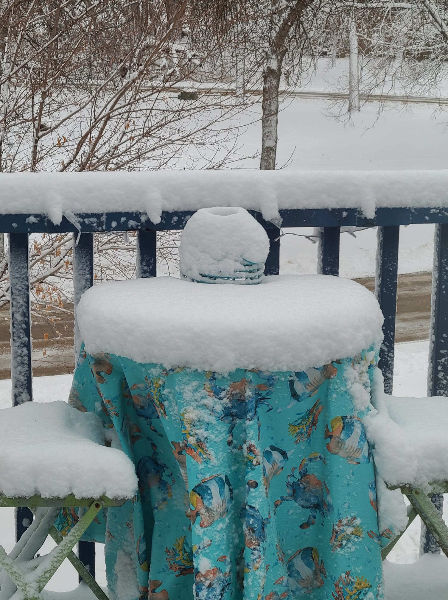 |
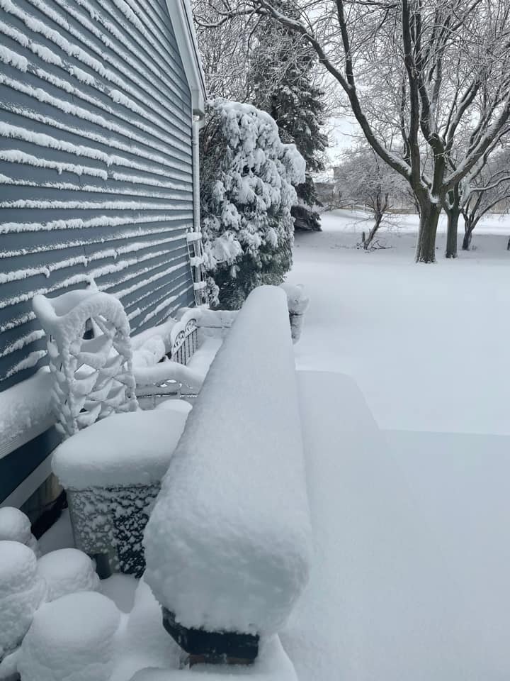
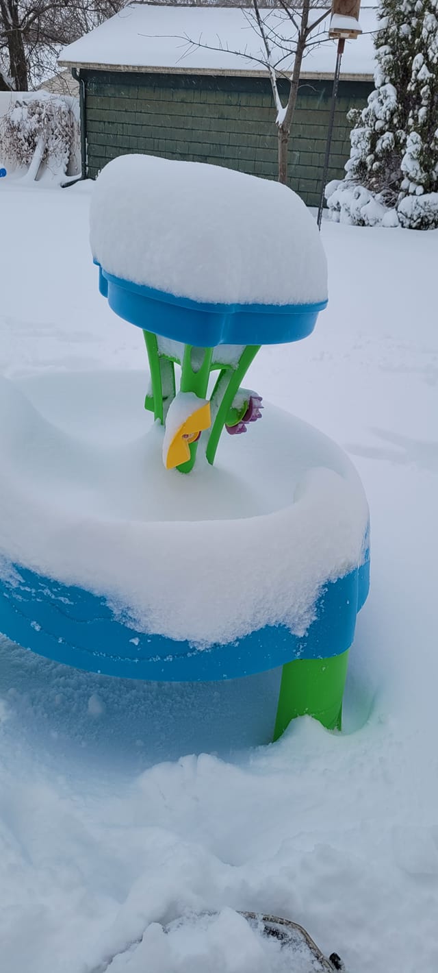
| Sioux Falls, SD (Debbie Ritter) |
Pipestone, MN (Lewis Epple) |
Brookings, SD (Chasity Kofford) |
Okoboji, IA (Dee Pyle) |
 |
 |
||
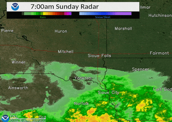
Radar
Header
 |
 |
||
| Radar for March 14-15th | Visible/IR Satellite for March 14-15th |
 |
Media use of NWS Web News Stories is encouraged! Please acknowledge the NWS as the source of any news information accessed from this site. |
|


 Weather Story
 Weather Map
 Local Radar