Overview
|
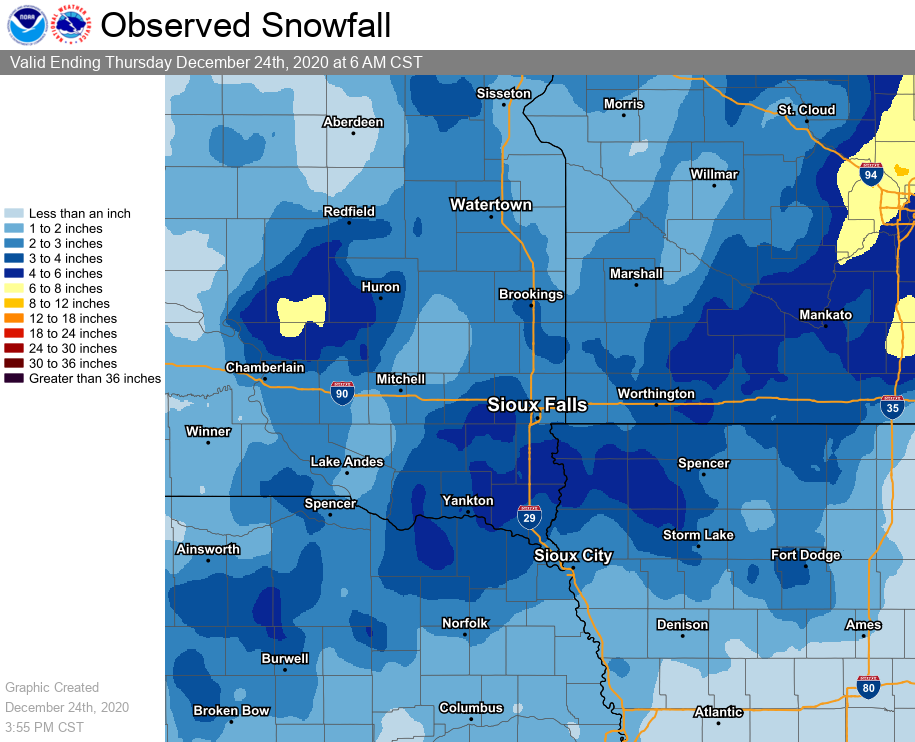
An arctic front and an intensifying storm system brought a dangerous combination of cold temperatures, high winds, and snowfall to the region prior to the Christmas holiday. As temperatures plummeted from the 50s on the 22nd of December to the teens on the 23rd, winds also intensified. The strongest reported wind gusts were observed between 60 and 70 mph. Snowfall totals between 2 and 6" were common through the region. The light and fluffy variety of snow made it easy for driving winds to reduce visibilities. Multiple hours of blizzard conditions were reported in the region, with blizzard warnings extending from Northern Minnesota through portions of the Dakotas, Iowa and Nebraska. |
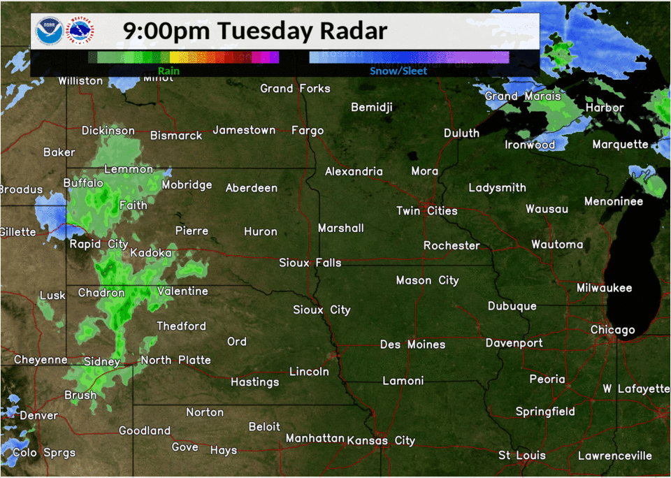 Radar Loop of the Blizzard |
 |
 |
 |
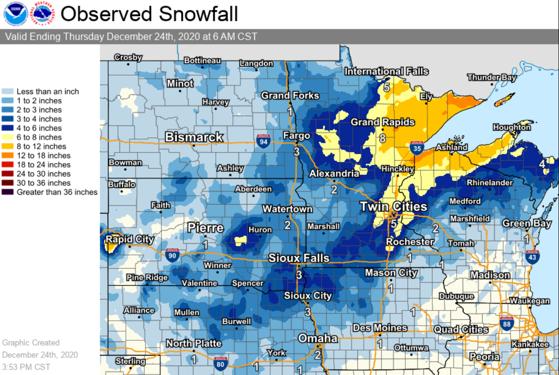
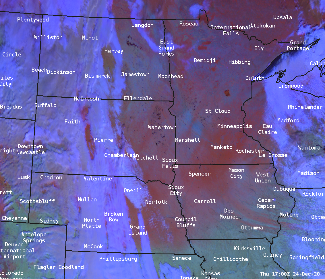
| Regional Snowfall Map | Regional Snow Cover After The Storm | Loop of Blizzard Winds |
Snow
Here is a map and listing of snowfall reports from this pre-Christmas Blizzard
 |
PRELIMINARY LOCAL STORM REPORT...SUMMARY
NATIONAL WEATHER SERVICE SIOUX FALLS SD
1058 AM CST THU DEC 24 2020

..TIME...   ...EVENT...      ...CITY LOCATION...     ...LAT.LON...
..DATE...   ....MAG....      ..COUNTY LOCATION..ST.. ...SOURCE....
            ..REMARKS..

0700 AM     SNOW             CANTON                  43.30N 96.58W
12/24/2020  M5.8 INCH        LINCOLN            SD   CO-OP OBSERVER


0700 AM     SNOW             SHELDON                 43.18N 95.84W
12/24/2020  M5.0 INCH        O'BRIEN            IA   CO-OP OBSERVER


0700 AM     SNOW             2 SE YANKTON            42.87N 97.36W
12/24/2020  M5.0 INCH        YANKTON            SD   CO-OP OBSERVER


0410 PM     SNOW             HULL                    43.19N 96.13W
12/23/2020  M4.5 INCH        SIOUX              IA   PUBLIC

            STORM TOTAL SNOWFALL. NEAR ZERO VISIBILITY
            AT TIME OF MEASUREMENT. REPORTED VIA SOCIAL
            MEDIA.

0415 PM     SNOW             TYNDALL                 42.99N 97.86W
12/23/2020  M4.5 INCH        BON HOMME          SD   CO-OP OBSERVER

            STORM TOTAL SNOWFALL.

0700 AM     SNOW             2 ENE CLAYTON           43.46N 97.62W
12/24/2020  M4.5 INCH        HUTCHINSON         SD   COCORAHS


0700 AM     SNOW             1 NE WALL LAKE          43.54N 96.94W
12/24/2020  M4.5 INCH        MINNEHAHA          SD   COCORAHS


0800 AM     SNOW             2 NE BROOKINGS          44.33N 96.76W
12/24/2020  M4.5 INCH        BROOKINGS          SD   CO-OP OBSERVER


0800 AM     SNOW             SPIRIT LAKE             43.42N 95.11W
12/24/2020  M4.3 INCH        DICKINSON          IA   CO-OP OBSERVER


0700 AM     SNOW             3 NNW WAHPETON          43.42N 95.19W
12/24/2020  M4.2 INCH        DICKINSON          IA   CO-OP OBSERVER


0700 AM     SNOW             7 S AVON                42.90N 98.04W
12/24/2020  M4.0 INCH        BON HOMME          SD   COCORAHS


0700 AM     SNOW             MONTROSE                43.70N 97.18W
12/24/2020  M4.0 INCH        MCCOOK             SD   CO-OP OBSERVER


0700 AM     SNOW             2 NNE WORTHINGTON       43.65N 95.58W
12/24/2020  M4.0 INCH        NOBLES             MN   CO-OP OBSERVER


0800 AM     SNOW             CHEROKEE                42.75N 95.55W
12/24/2020  M4.0 INCH        CHEROKEE           IA   CO-OP OBSERVER


0800 AM     SNOW             WINDOM                  43.87N 95.12W
12/24/2020  M4.0 INCH        COTTONWOOD         MN   CO-OP OBSERVER


0500 PM     SNOW             CONCORD                 42.38N 96.99W
12/23/2020  M3.5 INCH        DIXON              NE   CO-OP OBSERVER

            STORM TOTAL SNOWFALL.

0700 AM     SNOW             3 WNW EVERLY            43.18N 95.38W
12/24/2020  M3.5 INCH        CLAY               IA   CO-OP OBSERVER


0700 AM     SNOW             LAKE WILSON             43.99N 95.95W
12/24/2020  M3.5 INCH        MURRAY             MN   CO-OP OBSERVER


0700 AM     SNOW             4 S WORTHINGTON         43.57N 95.60W
12/24/2020  M3.3 INCH        NOBLES             MN   COCORAHS


0700 AM     SNOW             6 NNE ELK POINT         42.76N 96.64W
12/24/2020  M3.2 INCH        UNION              SD   COCORAHS


0700 AM     SNOW             5 W BRUCE               44.44N 96.99W
12/24/2020  M3.0 INCH        BROOKINGS          SD   COCORAHS


0700 AM     SNOW             LAKE PARK               43.45N 95.32W
12/24/2020  M3.0 INCH        DICKINSON          IA   COCORAHS


0700 AM     SNOW             6 NW MONTROSE           43.76N 97.27W
12/24/2020  M3.0 INCH        MCCOOK             SD   COCORAHS


0700 AM     SNOW             10 E NUNDA              44.14N 96.82W
12/24/2020  M3.0 INCH        MOODY              SD   COCORAHS


0700 AM     SNOW             ORANGE CITY             43.00N 96.06W
12/24/2020  M3.0 INCH        SIOUX              IA   CO-OP OBSERVER


0700 AM     SNOW             2 W SERGEANT BLUFF      42.40N 96.39W
12/24/2020  M3.0 INCH        WOODBURY           IA   OFFICIAL NWS OBS


0700 AM     SNOW             1 N SPENCER             43.16N 95.15W
12/24/2020  M3.0 INCH        CLAY               IA   CO-OP OBSERVER


0700 AM     SNOW             STORM LAKE              42.65N 95.20W
12/24/2020  M3.0 INCH        BUENA VISTA        IA   CO-OP OBSERVER


0800 AM     SNOW             SIOUX RAPIDS            42.89N 95.15W
12/24/2020  M3.0 INCH        BUENA VISTA        IA   CO-OP OBSERVER


0700 AM     SNOW             REMSEN                  42.81N 95.97W
12/24/2020  M2.8 INCH        PLYMOUTH           IA   CO-OP OBSERVER


0800 AM     SNOW             2 SE MADISON            43.99N 97.08W
12/24/2020  M2.8 INCH        LAKE               SD   CO-OP OBSERVER


1200 PM     SNOW             HURON                   44.36N 98.22W
12/23/2020  M2.5 INCH        BEADLE             SD   OFFICIAL NWS OBS


0700 AM     SNOW             EDGERTON                43.87N 96.13W
12/24/2020  M2.5 INCH        PIPESTONE          MN   COCORAHS


0700 AM     SNOW             HILLS                   43.53N 96.36W
12/24/2020  M2.5 INCH        ROCK               MN   PUBLIC


0315 PM     SNOW             VERMILLION              42.78N 96.93W
12/23/2020  M2.4 INCH        CLAY               SD   CO-OP OBSERVER

            CORRECTS PREVIOUS SNOW REPORT FROM
            VERMILLION. STORM TOTAL SNOWFALL.

0320 PM     SNOW             MITCHELL                43.73N 98.03W
12/23/2020  M2.2 INCH        DAVISON            SD   CO-OP OBSERVER

            STORM TOTAL SNOWFALL. OFFICIAL OBSERVER
            REPORT FOR MITCHELL.

0200 PM     SNOW             3 NNW SIOUX FALLS       43.58N 96.75W
12/23/2020  M2.1 INCH        MINNEHAHA          SD   OFFICIAL NWS OBS


0700 AM     SNOW             DE SMET                 44.39N 97.55W
12/24/2020  M2.0 INCH        KINGSBURY          SD   COCORAHS


0700 AM     SNOW             6 SSW HERRICK           43.04N 99.21W
12/24/2020  M2.0 INCH        GREGORY            SD   COCORAHS


0700 AM     SNOW             4 SW IVANHOE            44.43N 96.31W
12/24/2020  M2.0 INCH        LINCOLN            MN   COCORAHS


0700 AM     SNOW             LE MARS                 42.79N 96.17W
12/24/2020  M2.0 INCH        PLYMOUTH           IA   CO-OP OBSERVER


0700 AM     SNOW             WHITE                   44.43N 96.65W
12/24/2020  M2.0 INCH        BROOKINGS          SD   COCORAHS


0700 AM     SNOW             PIPESTONE               44.00N 96.31W
12/24/2020  M1.8 INCH        PIPESTONE          MN   PUBLIC

            CORRECTS PREVIOUS SNOW REPORT FROM
            PIPESTONE.

0700 AM     SNOW             2 N LAKE ANDES          43.18N 98.53W
12/24/2020  M1.5 INCH        CHARLES MIX        SD   COCORAHS


0700 AM     SNOW             8 SSW CHAMBERLAIN       43.70N 99.38W
12/24/2020  M1.0 INCH        BRULE              SD   COCORAHS


0700 AM     SNOW             9 S DALLAS              43.11N 99.52W
12/24/2020  M1.0 INCH        GREGORY            SD   COCORAHS
|
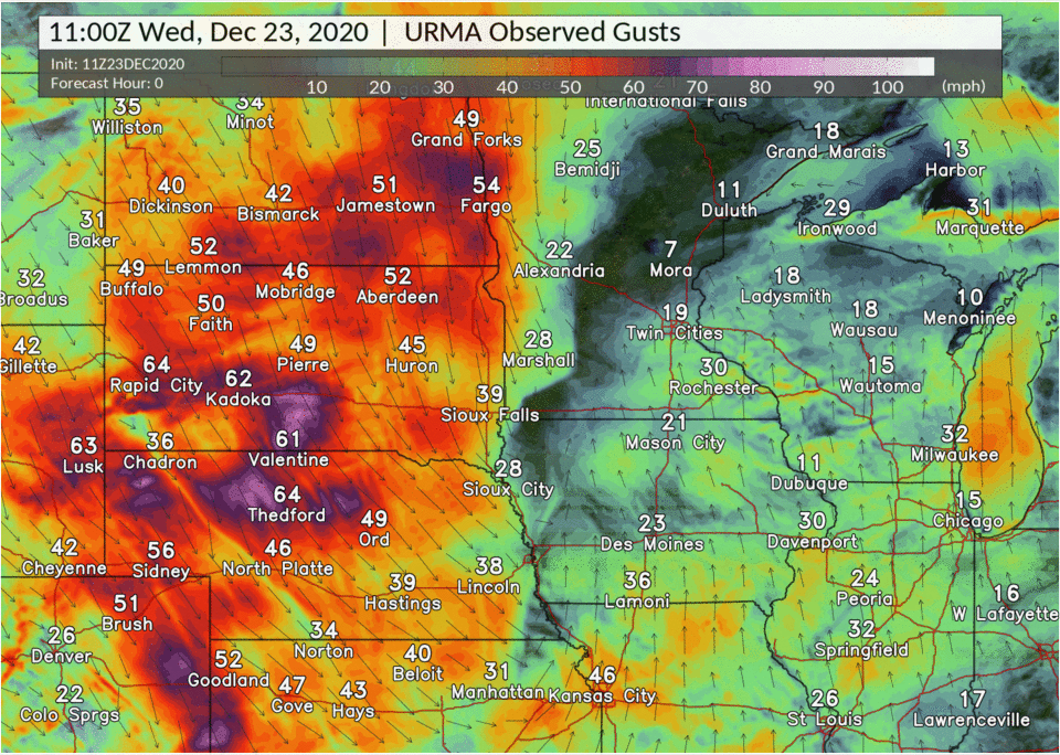
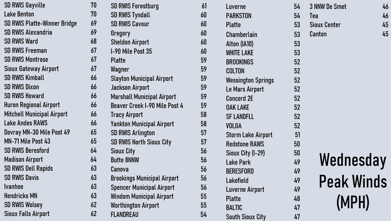
Strong Winds
This late December storm brought significant winds to much of the region. Winds in some locations gusted over 60 mph and in a few spots over 70 mph. The images below show the peak winds observed across the region
 |
|
|
Listing of Peak Wind Gusts (MPH) from Wednesday December 23rd. |
|
Location Speed Time/Date SD RWIS Gayville 70 MPH 0114 PM 12/23 Lake Benton US-14 Mile Post 70 MPH 1051 AM 12/23 SD RWIS Platte-Winner Bridge 69 MPH 1028 AM 12/23 SD RWIS Alexandria 69 MPH 1149 AM 12/23 SD RWIS Ward 68 MPH 1130 AM 12/23 SD RWIS Freeman 67 MPH 1233 PM 12/23 SD RWIS Montrose 67 MPH 1234 PM 12/23 Sioux Gateway Airport 67 MPH 1252 PM 12/23 SD RWIS Kimball 66 MPH 1049 AM 12/23 SD RWIS Dixon Junction of SD 66 MPH 1134 AM 12/23 SD RWIS Howard Junction of S 66 MPH 1144 AM 12/23 Huron Regional Airport 66 MPH 1055 AM 12/23 Mitchell Municipal Airport 66 MPH 1253 PM 12/23 Lake Andes RAWS 66 MPH 1141 AM 12/23 Dovray MN-30 Mile Post 49 65 MPH 1205 PM 12/23 SD RWIS Beresford 64 MPH 0134 PM 12/23 Madison Airport 64 MPH 1215 PM 12/23 SD RWIS Dell Rapids 63 MPH 1254 PM 12/23 SD RWIS Davis 63 MPH 0215 PM 12/23 Ivanhoe 63 MPH 1210 PM 12/23 Hendricks MN-19 Mile Post 2 63 MPH 1135 AM 12/23 SD RWIS Wolsey 62 MPH 1045 AM 12/23 Sioux Falls Airport 62 MPH 1156 AM 12/23 SD RWIS Forestburg 61 MPH 1135 AM 12/23 SD RWIS Tyndall 60 MPH 1144 AM 12/23 SD RWIS Cavour 60 MPH 1030 AM 12/23 Gregory 60 MPH 0955 AM 12/23 Sheldon Airport 60 MPH 0355 PM 12/23 I-90 Mile Post 35 60 MPH 0300 PM 12/23 Platte 59 MPH 1055 AM 12/23 Wagner 59 MPH 1155 AM 12/23 Slayton Municipal Airport 59 MPH 0353 PM 12/23 Jackson Airport 59 MPH 0355 PM 12/23 Marshall Municipal Airport 59 MPH 1056 AM 12/23 Beaver Creek I-90 Mile Post 59 MPH 1140 AM 12/23 Tracy Airport 58 MPH 0235 PM 12/23 Yankton Municipal Airport 58 MPH 0855 AM 12/23 MN-71 Mile Post 43 58 MPH 0310 PM 12/23 |
Location Speed Time/Date SD RWIS Arlington 57 MPH 0235 PM 12/23 SD RWIS North Sioux City 57 MPH 0114 PM 12/23 Sioux City 56 MPH 0906 AM 12/23 Butte 8NNW 56 MPH 1131 AM 12/23 Canova 56 MPH 1150 AM 12/23 Brookings Municipal Airport 56 MPH 1256 PM 12/23 Spencer Municipal Airport 56 MPH 0253 PM 12/23 Windom Municipal Airport 55 MPH 0341 PM 12/23 Worthington Airport 55 MPH 0136 PM 12/23 FLANDREAU 54 MPH 1045 AM 12/23 Luverne 54 MPH 0231 PM 12/23 PARKSTON 54 MPH 1210 PM 12/23 Platte 53 MPH 1105 AM 12/23 Chamberlain Municipal Airpor 53 MPH 0915 AM 12/23 Alton (IA10) 53 MPH 0210 PM 12/23 WHITE LAKE 53 MPH 1120 AM 12/23 BROOKINGS 52 MPH 0110 PM 12/23 COLTON 52 MPH 1210 PM 12/23 Wessington Springs 52 MPH 1155 AM 12/23 Le Mars Airport 52 MPH 0335 PM 12/23 Concord 2E 52 MPH 0325 PM 12/23 OAK LAKE 52 MPH 0945 AM 12/23 SF LANDFLL 52 MPH 0120 PM 12/23 VOLGA 52 MPH 1230 PM 12/23 Storm Lake Airport 51 MPH 1115 AM 12/23 Redstone RAWS 50 MPH 1221 PM 12/23 Sioux City (I-29) 50 MPH 0350 PM 12/23 Lake Park 49 MPH 0245 PM 12/23 BERESFORD 49 MPH 0225 PM 12/23 Lakefield 49 MPH 0321 PM 12/23 Luverne Airport 49 MPH 0155 PM 12/23 Platte 48 MPH 1046 AM 12/23 BALTIC 47 MPH 0300 PM 12/23 South Sioux City 47 MPH 0345 PM 12/23 3 NNW De Smet 46 MPH 1055 AM 12/23 Tea 46 MPH 0155 PM 12/23 Sioux Center 45 MPH 0218 PM 12/23 Canton 45 MPH 0155 PM 12/23 |
.
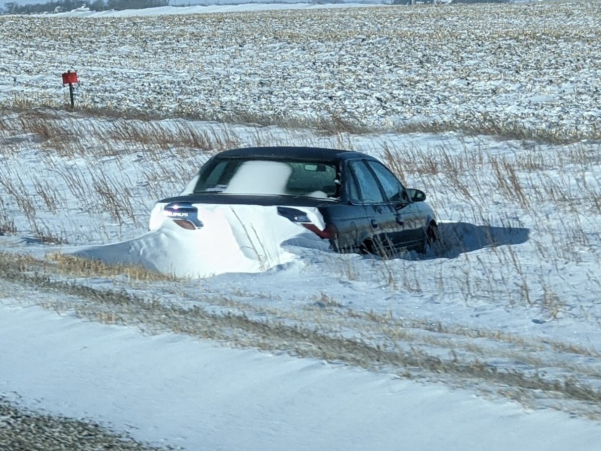
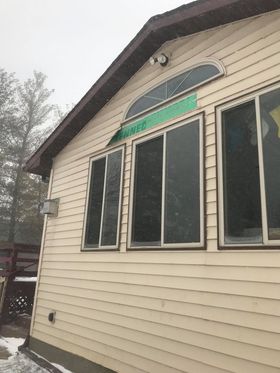
Photos & Video
 |
 |
 |
| Vehicle In Ditch (Dickinson County EM) |
Blown Over Semi (Dickinson County EM) |
Damage to Siding |
 |
Media use of NWS Web News Stories is encouraged! Please acknowledge the NWS as the source of any news information accessed from this site. |
|


 Weather Story
 Weather Map
 Local Radar