Overview
|
A relatively quick-moving, but occasionally heavy band of rain and snow moved across the region on Tuesday, October 20, 2020. While some areas saw primarily rain, moderate to heavy snow fell in a swath from northeast and east central South Dakota, across central and southern Minnesota, generally north of Interstate 90. For the NWS Sioux Falls forecast area, the heaviest snow was reported near & north of the Highway 14 corridor from around Brookings eastward, with amounts tapering off rapidly in areas south of SD Highway 34/MN Highway 30. |
This Page is a Work In Progress |
Storm Reports
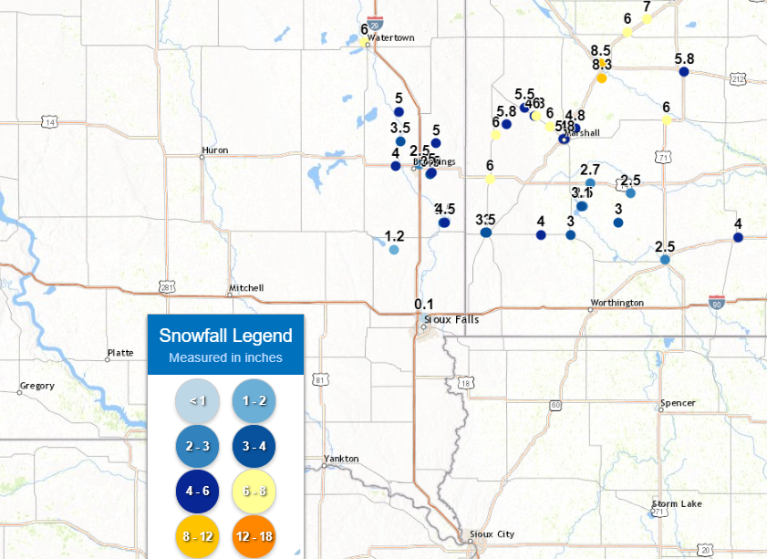
PRELIMINARY LOCAL STORM REPORT...SUMMARY
NATIONAL WEATHER SERVICE SIOUX FALLS SD
828 PM CDT TUE OCT 20 2020

..TIME...   ...EVENT...      ...CITY LOCATION...     ...LAT.LON...
..DATE...   ....MAG....      ..COUNTY LOCATION..ST.. ...SOURCE....
            ..REMARKS..

1125 AM     SNOW             SLAYTON                 43.99N 95.75W
10/20/2020  E3.0 INCH        MURRAY             MN   NEWSPAPER


1130 AM     SNOW             5 NE IVANHOE            44.52N 96.18W
10/20/2020  M5.8 INCH        LINCOLN            MN   TRAINED SPOTTER


1145 AM     SNOW             LAKE WILSON             43.99N 95.95W
10/20/2020  M4.0 INCH        MURRAY             MN   CO-OP OBSERVER


1155 AM     SNOW             PIPESTONE               44.00N 96.32W
10/20/2020  M3.5 INCH        PIPESTONE          MN   TRAINED SPOTTER


1220 PM     SNOW             11 N STORDEN            44.19N 95.35W
10/20/2020  E2.5 INCH        COTTONWOOD         MN   TRAINED SPOTTER


1230 PM     SNOW             TAUNTON                 44.60N 96.06W
10/20/2020  E5.5 INCH        LYON               MN   TRAINED SPOTTER


1240 PM     SNOW             WESTBROOK               44.05N 95.43W
10/20/2020  E3.0 INCH        COTTONWOOD         MN   PUBLIC

            REPORT VIA SOCIAL MEDIA.

1242 PM     SNOW             5 NE MARSHALL           44.50N 95.72W
10/20/2020  M4.8 INCH        LYON               MN   TRAINED SPOTTER


0100 PM     HEAVY SNOW       LAKE BENTON             44.26N 96.29W
10/20/2020  M6.0 INCH        LINCOLN            MN   PUBLIC

            REPORT VIA SOCIAL MEDIA.

0115 PM     SNOW             VOLGA                   44.32N 96.92W
10/20/2020  E4.0 INCH        BROOKINGS          SD   PUBLIC

            REPORT VIA SOCIAL MEDIA.

0300 PM     SNOW             0.3 NE AURORA           44.29N 96.68W
10/20/2020  M5.0 INCH        BROOKINGS          SD   COCORAHS

            STORM TOTAL SNOWFALL.

0300 PM     SNOW             0.1 S WHITE             44.43N 96.65W
10/20/2020  M5.0 INCH        BROOKINGS          SD   COCORAHS

            STORM TOTAL SNOWFALL.

0315 PM     SNOW             FLANDREAU               44.05N 96.59W
10/20/2020  M4.5 INCH        MOODY              SD   CO-OP OBSERVER

            STORM TOTAL SNOWFALL.

0335 PM     HEAVY SNOW       IVANHOE                 44.47N 96.25W
10/20/2020  E6.0 INCH        LINCOLN            MN   PUBLIC

            STORM TOTAL SNOWFALL. AVERAGE OF MULTIPLE MEASUREMENTS.
            REPORTED VIA SOCIAL MEDIA.

0430 PM     SNOW             PIPESTONE               44.00N 96.31W
10/20/2020  M3.0 INCH        PIPESTONE          MN   TRAINED SPOTTER

            STORM TOTAL SNOWFALL. STORM TOTAL SNOWFALL.

0432 PM     SNOW             BRUCE                   44.44N 96.89W
10/20/2020  M3.5 INCH        BROOKINGS          SD   PUBLIC

            STORM TOTAL SNOWFALL. REPORTED VIA SOCIAL MEDIA.

0500 PM     SNOW             4 N CURRIE              44.13N 95.68W
10/20/2020  M3.1 INCH        MURRAY             MN   TRAINED SPOTTER

            STORM TOTAL SNOWFALL.

0500 PM     SNOW             3 N SIOUX FALLS         43.59N 96.73W
10/20/2020  M0.1 INCH        MINNEHAHA          SD   OFFICIAL NWS OBS

            STORM TOTAL SNOWFALL.

0530 PM     SNOW             MARSHALL                44.45N 95.79W
10/20/2020  M5.8 INCH        LYON               MN   PUBLIC

            STORM TOTAL SNOWFALL. REPORTED VIA SOCIAL MEDIA.

0532 PM     HEAVY SNOW       GHENT                   44.51N 95.89W
10/20/2020  M6.0 INCH        LYON               MN   TRAINED SPOTTER

            STORM TOTAL SNOWFALL.

0645 PM     SNOW             WINDOM                  43.87N 95.12W
10/20/2020  M2.5 INCH        COTTONWOOD         MN   CO-OP OBSERVER

            STORM TOTAL SNOWFALL.

0650 PM     HEAVY SNOW       MINNEOTA                44.56N 95.98W
10/20/2020  M6.0 INCH        LYON               MN   PUBLIC

            STORM TOTAL SNOWFALL. REPORTED VIA SOCIAL
            MEDIA.


&&

$$
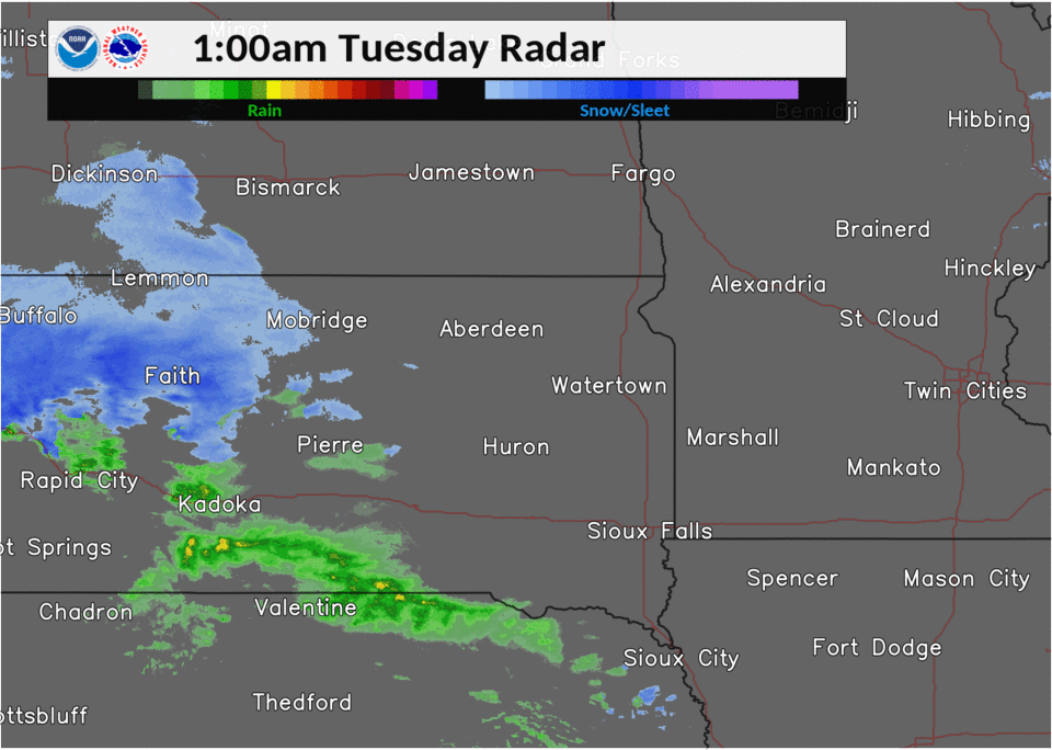
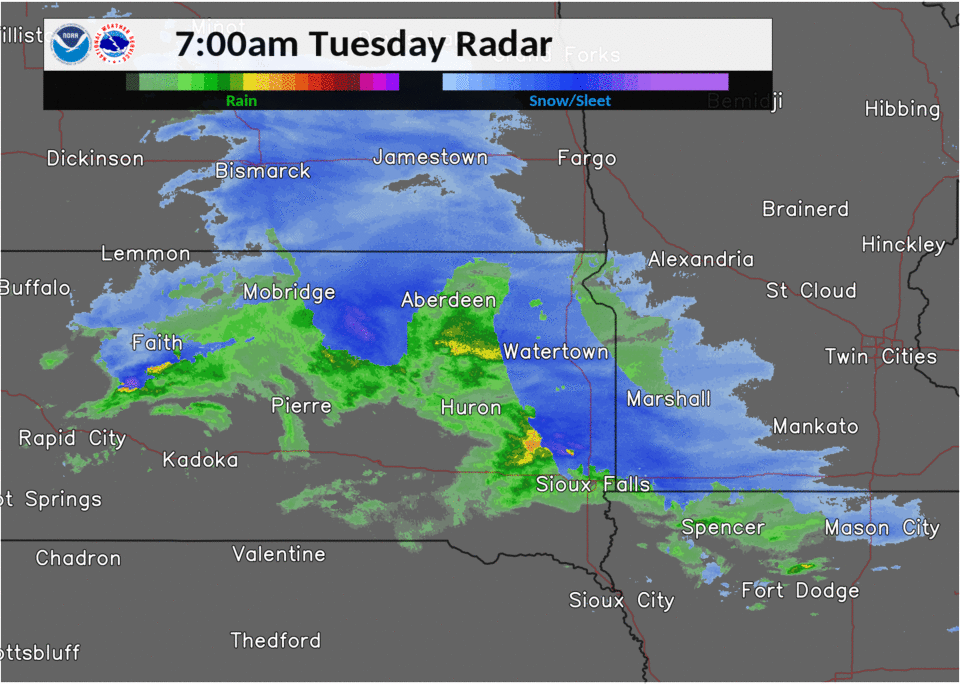
Radar
 |
 |
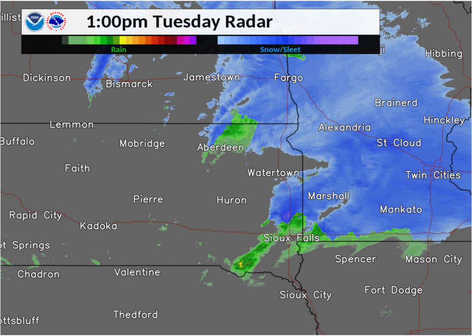 |
| Radar Loop, 1 am to 7 am, October 20, 2020 | Radar Loop, 7 am to 1 pm, October 20, 2020 | Radar Loop, 1 pm to 7 pm, October 20, 2020 |
Photos & Video
Header
| Caption (source) |
Caption (source) |
Caption (source) |
Caption (source) |
 |
Media use of NWS Web News Stories is encouraged! Please acknowledge the NWS as the source of any news information accessed from this site. |
|


 Weather Story
 Weather Map
 Local Radar