Overview
|
An intense band of heavy snow developed over parts of east central SD into southwest MN Saturday night into early Sunday morning. The highest reports within the band of heavy snow were 10 to 12 inches along highway 14 while amounts closer to I-90 in SD were a half an inch to 2 inches and 2 to 5 inches along I-90 in southwest MN. A few locations reported as much as 2 inches per hour for a brief time. |
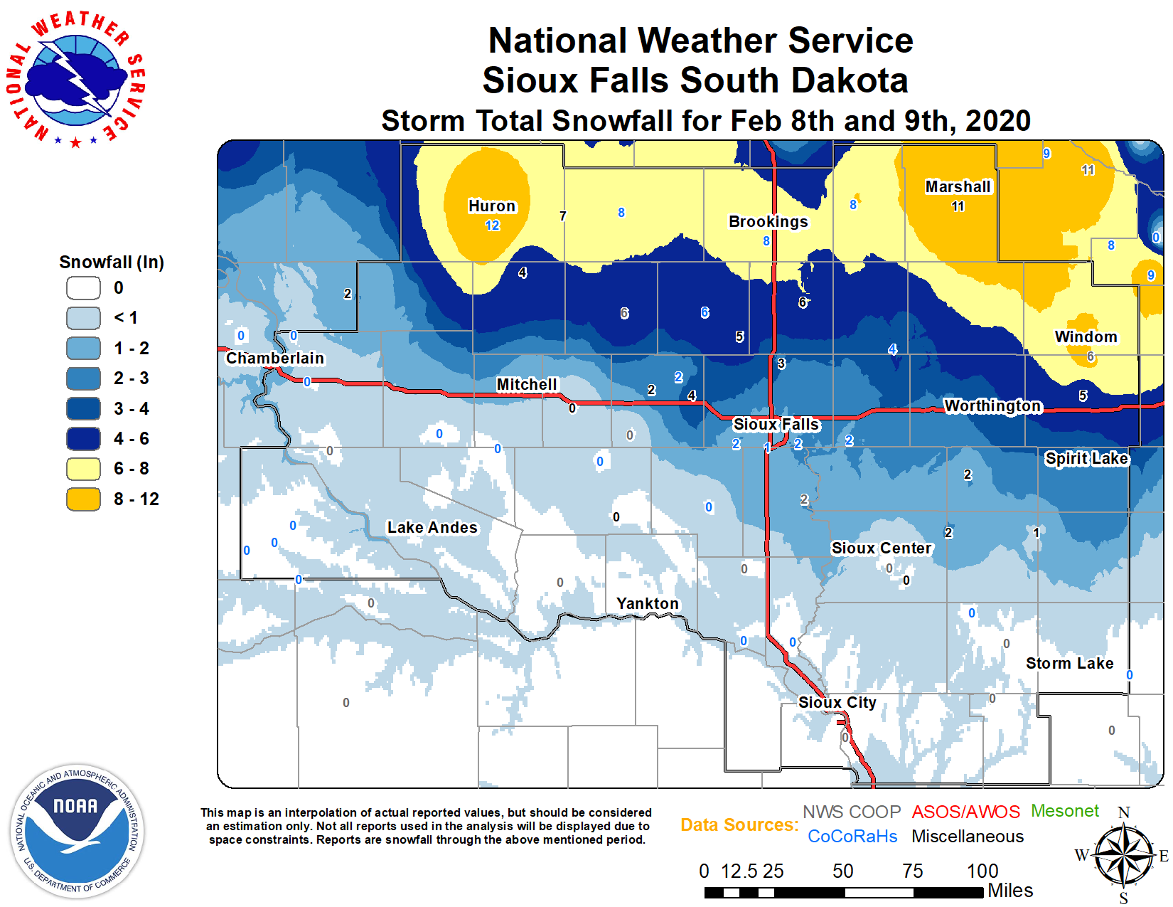 Storm Total Snowfall Report Map |
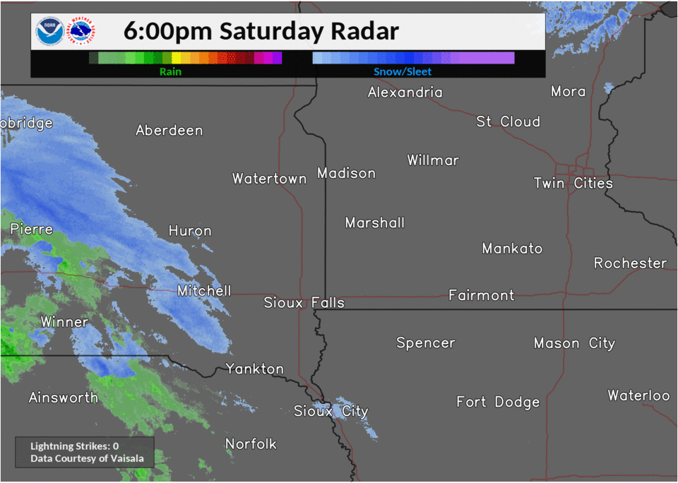
Radar
6-hour radar loops showing the heavy snow band moving across the region. Note from midnight to 6 am, a few lightning strikes (white dots) were detected by remote sensors!
 |
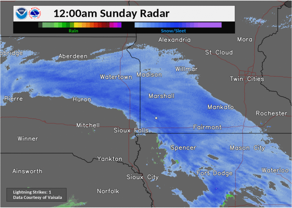 |
| 6 pm to midnight Saturday night | Midnight to 6 am Sunday |
Storm Reports
PRELIMINARY LOCAL STORM REPORT...SUMMARY
NATIONAL WEATHER SERVICE SIOUX FALLS SD
1102 AM CST SUN FEB 9 2020

..TIME...   ...EVENT...      ...CITY LOCATION...     ...LAT.LON...
..DATE...   ....MAG....      ..COUNTY LOCATION..ST.. ...SOURCE....
            ..REMARKS..

0700 AM     HEAVY SNOW       DE SMET                 44.39N 97.55W
02/09/2020  M12.6 INCH       KINGSBURY          SD   CO-OP OBSERVER


0800 AM     HEAVY SNOW       LYND                    44.39N 95.90W
02/09/2020  M12.0 INCH       LYON               MN   PUBLIC

            REPORT VIA SOCIAL MEDIA.
0850 AM     HEAVY SNOW       3 NNE HURON             44.36N 98.21W
02/09/2020  M12.0 INCH       BEADLE             SD   PUBLIC

            REPORTED VIA SOCIAL MEDIA.

0700 AM     SNOW             1 S MARSHALL            44.44N 95.79W
02/09/2020  M11.0 INCH       LYON               MN   COCORAHS


0600 AM     HEAVY SNOW       2 S HURON               44.34N 98.22W
02/09/2020  M10.4 INCH       BEADLE             SD   OFFICIAL NWS OBS

            STORM TOTAL SNOWFALL.

0609 AM     HEAVY SNOW       MINNEOTA                44.56N 95.98W
02/09/2020  M9.9 INCH        LYON               MN   PUBLIC

            REPORTED VIA SOCIAL MEDIA.

0800 AM     HEAVY SNOW       4 N CURRIE              44.13N 95.67W
02/09/2020  E9.0 INCH        MURRAY             MN   EMERGENCY MNGR


0800 AM     HEAVY SNOW       4 SW IVANHOE            44.43N 96.31W
02/09/2020  M8.5 INCH        LINCOLN            MN   COCORAHS


0730 AM     HEAVY SNOW       VOLGA                   44.32N 96.92W
02/09/2020  M8.3 INCH        BROOKINGS          SD   PUBLIC


0800 AM     HEAVY SNOW       1 W BROOKINGS           44.31N 96.81W
02/09/2020  M7.2 INCH        BROOKINGS          SD   PUBLIC

            REPORT VIA SOCIAL MEDIA.

0800 AM     SNOW             WINDOM                  43.87N 95.12W
02/09/2020  M6.2 INCH        COTTONWOOD         MN   CO-OP OBSERVER


0700 AM     SNOW             FLANDREAU               44.05N 96.60W
02/09/2020  M5.5 INCH        MOODY              SD   CO-OP OBSERVER


0800 AM     SNOW             MADISON                 44.01N 97.11W
02/09/2020  M5.5 INCH        LAKE               SD   COCORAHS


0800 AM     SNOW             2 NE LAKEFIELD          43.70N 95.14W
02/09/2020  M5.4 INCH        JACKSON            MN   CO-OP OBSERVER


0700 AM     SNOW             2 N CHESTER             43.92N 96.93W
02/09/2020  M5.1 INCH        LAKE               SD   CO-OP OBSERVER


0700 AM     SNOW             EDGERTON                43.87N 96.13W
02/09/2020  M4.5 INCH        PIPESTONE          MN   COCORAHS


0700 AM     SNOW             2 NNE WORTHINGTON       43.65N 95.58W
02/09/2020  M4.0 INCH        NOBLES             MN   CO-OP OBSERVER


0645 AM     SNOW             DELL RAPIDS             43.82N 96.71W
02/09/2020  E3.0 INCH        MINNEHAHA          SD   PUBLIC

            REPORT VIA SOCIAL MEDIA.

0700 AM     SNOW             SALEM                   43.72N 97.39W
02/09/2020  E2.5 INCH        MCCOOK             SD   PUBLIC


0800 AM     SNOW             MONTROSE                43.70N 97.18W
02/09/2020  M2.0 INCH        MCCOOK             SD   CO-OP OBSERVER


1141 PM     SNOW             3 SE SIOUX FALLS        43.50N 96.70W
02/08/2020  M1.9 INCH        MINNEHAHA          SD   NWS EMPLOYEE

            MEASURED NEAR CLIFF AVE AND 57TH ST.

0600 AM     SNOW             3 N SIOUX FALLS         43.59N 96.73W
02/09/2020  M1.8 INCH        MINNEHAHA          SD   OFFICIAL NWS OBS


1230 AM     SNOW             4 ESE SIOUX FALLS       43.53N 96.66W
02/09/2020  M1.8 INCH        MINNEHAHA          SD   NWS EMPLOYEE

            MEASURED NEAR 26TH ST AND SYCAMORE AVE.

0700 AM     SNOW             CHAMBERLAIN             43.81N 99.32W
02/09/2020  M1.8 INCH        BRULE              SD   COCORAHS


0800 AM     SNOW             CANTON                  43.30N 96.58W
02/09/2020  M1.5 INCH        LINCOLN            SD   CO-OP OBSERVER


0700 AM     SNOW             SIBLEY                  43.40N 95.74W
02/09/2020  M1.5 INCH        OSCEOLA            IA   CO-OP OBSERVER


0700 AM     SNOW             MITCHELL                43.73N 98.03W
02/09/2020  M1.4 INCH        DAVISON            SD   CO-OP OBSERVER


0700 AM     SNOW             SHELDON                 43.18N 95.84W
02/09/2020  M1.0 INCH        O`BRIEN            IA   CO-OP OBSERVER


0700 AM     SNOW             ORANGE CITY             43.00N 96.06W
02/09/2020  M0.3 INCH        SIOUX              IA   CO-OP OBSERVER
 |
Media use of NWS Web News Stories is encouraged! Please acknowledge the NWS as the source of any news information accessed from this site. |
|


 Weather Story
 Weather Map
 Local Radar