Overview
|
A disturbance lifting out of the southern Plains generated an area of snowfall across far southeast South Dakota, northeast Nebraska, northwest Iowa and southwest Minnesota on Sunday, January 12. An initial, fairly narrow band developed Sunday morning from northeast Nebraska into northwest Iowa, and lifted north toward Interstate 90 by early afternoon. As the main system moved into the area during the afternoon, additional snowfall expanded from eastern Nebraska into northwest Iowa. The snowfall contracted into a couple of locally heavier bands, with general 1 to 3 inches of snowfall surrounding narrow zones of 4 to 7 inches. |
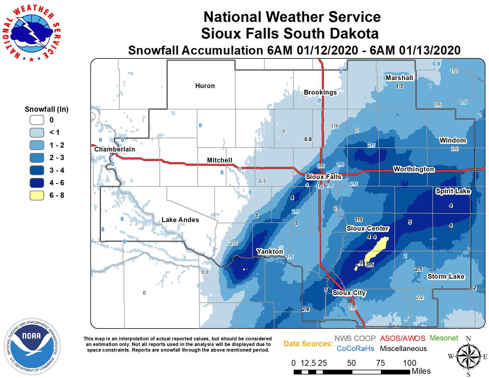 Storm Total Snowfall from January 12, 2020 |
Snow/Ice
PRELIMINARY LOCAL STORM REPORT...SUMMARY
NATIONAL WEATHER SERVICE SIOUX FALLS SD
1110 AM CST MON JAN 13 2020

..TIME...   ...EVENT...      ...CITY LOCATION...     ...LAT.LON...
..DATE...   ....MAG....      ..COUNTY LOCATION..ST.. ...SOURCE....
            ..REMARKS..

0700 AM     HEAVY SNOW       ORANGE CITY             43.00N 96.05W
01/13/2020  M7.0 INCH        SIOUX              IA   CO-OP OBSERVER


0912 PM     HEAVY SNOW       ALTON                   42.99N 96.01W
01/12/2020  M6.5 INCH        SIOUX              IA   PUBLIC

            STORM TOTAL. VIA SOCIAL MEDIA.

0800 AM     SNOW             HARTLEY                 43.18N 95.48W
01/13/2020  M5.3 INCH        OBRIEN            IA   PUBLIC


0922 PM     SNOW             SANBORN                 43.18N 95.66W
01/12/2020  M5.0 INCH        OBRIEN            IA   PUBLIC

            STORM TOTAL. VIA SOCIAL MEDIA.

0728 PM     SNOW             PONCA                   42.56N 96.71W
01/12/2020  E5.0 INCH        DIXON              NE   PUBLIC

            REPORT VIA SOCIAL MEDIA.

0700 AM     SNOW             1 E SPIRIT LAKE         43.42N 95.10W
01/13/2020  M4.1 INCH        DICKINSON          IA   CO-OP OBSERVER

            CO-OP OBSERVER STATION SPRI4 0.6 E SPIRIT
            LAKE.

0930 AM     SNOW             PETERSON                42.92N 95.34W
01/13/2020  M4.0 INCH        CLAY               IA   PUBLIC


0800 AM     SNOW             1 ENE WALL LAKE         43.53N 96.95W
01/13/2020  M4.0 INCH        MINNEHAHA          SD   COCORAHS

            COCORAHS STATION SD-MH-8 HARTFORD 6.4 S.

0700 AM     SNOW             SIOUX CENTER            43.08N 96.17W
01/13/2020  M4.0 INCH        SIOUX              IA   BROADCAST MEDIA


0700 AM     SNOW             2 NNE WORTHINGTON       43.65N 95.58W
01/13/2020  M4.0 INCH        NOBLES             MN   CO-OP OBSERVER

            CO-OP OBSERVER STATION WRNM5 WORTHINGTON 2
            NNE.

0600 AM     SNOW             SHELDON                 43.18N 95.84W
01/13/2020  M4.0 INCH        OBRIEN            IA   PUBLIC

            REPORT VIA SOCIAL MEDIA.

0939 PM     SNOW             4 E SIOUX CENTER        43.07N 96.10W
01/12/2020  E4.0 INCH        SIOUX              IA   PUBLIC

            STORM TOTAL. VIA SOCIAL MEDIA.

0930 PM     SNOW             MILFORD                 43.33N 95.15W
01/12/2020  M4.0 INCH        DICKINSON          IA   PUBLIC


0928 PM     SNOW             SPENCER                 43.15N 95.15W
01/12/2020  M4.0 INCH        CLAY               IA   PUBLIC

            STORM TOTAL. VIA SOCIAL MEDIA.

0538 PM     SNOW             PARKER                  43.40N 97.13W
01/12/2020  M4.0 INCH        TURNER             SD   PUBLIC

            VIA SOCIAL MEDIA. STILL SNOWING LIGHTLY AT
            TIME OF REPORT.

0700 AM     SNOW             SHELDON                 43.18N 95.85W
01/13/2020  M3.5 INCH        OBRIEN            IA   CO-OP OBSERVER

            CO-OP OBSERVER STATION SHDI4 SHELDON.

0600 AM     SNOW             EDGERTON                43.87N 96.13W
01/13/2020  M3.5 INCH        PIPESTONE          MN   COCORAHS

            COCORAHS STATION MN-PS-6 EDGERTON 0.2 WSW.

0913 PM     SNOW             LE MARS                 42.79N 96.16W
01/12/2020  M3.5 INCH        PLYMOUTH           IA   PUBLIC

            STORM TOTAL. VIA SOCIAL MEDIA.

0800 AM     SNOW             4 NW OKOBOJI            43.43N 95.18W
01/13/2020  M3.2 INCH        DICKINSON          IA   TRAINED SPOTTER


0800 AM     SNOW             ROCK RAPIDS             43.43N 96.17W
01/13/2020  M3.0 INCH        LYON               IA   CO-OP OBSERVER


0940 PM     SNOW             BRUNSVILLE              42.81N 96.27W
01/12/2020  E3.0 INCH        PLYMOUTH           IA   PUBLIC


0906 PM     SNOW             VIBORG                  43.17N 97.08W
01/12/2020  E3.0 INCH        TURNER             SD   PUBLIC

            STORM TOTAL. VIA SOCIAL MEDIA.

0653 PM     SNOW             2 E CROOKS              43.66N 96.77W
01/12/2020  M3.0 INCH        MINNEHAHA          SD   PUBLIC


0800 AM     SNOW             REMSEN                  42.81N 95.97W
01/13/2020  M2.8 INCH        PLYMOUTH           IA   CO-OP OBSERVER


0800 AM     SNOW             3 NE CROOKS             43.69N 96.76W
01/13/2020  M2.8 INCH        MINNEHAHA          SD   COCORAHS


0700 AM     SNOW             3 NE CROOKS             43.69N 96.78W
01/13/2020  M2.8 INCH        MINNEHAHA          SD   COCORAHS

            COCORAHS STATION SD-MH-71 RENNER 4.1 NW.

0500 PM     SNOW             2 E CONCORD             42.38N 96.96W
01/12/2020  M2.8 INCH        DIXON              NE   CO-OP OBSERVER

            CO-OP OBSERVER STATION NESN1 CONCORD.

0700 AM     SNOW             1 WNW EDGERTON          43.88N 96.14W
01/13/2020  M2.5 INCH        PIPESTONE          MN   COCORAHS

            COCORAHS STATION MN-PS-1 EDGERTON 0.5 W.

0600 AM     SNOW             HURLEY                  43.28N 97.09W
01/13/2020  M2.5 INCH        TURNER             SD   COCORAHS

            COCORAHS STATION SD-TR-9 HURLEY 0.2 S.

0916 PM     SNOW             CHEROKEE                42.75N 95.55W
01/12/2020  M2.5 INCH        CHEROKEE           IA   PUBLIC

            STORM TOTAL. VIA SOCIAL MEDIA.

0914 PM     SNOW             SOUTH SIOUX CITY        42.47N 96.42W
01/12/2020  M2.5 INCH        DAKOTA             NE   EMERGENCY MNGR

            STORM TOTAL.

0510 PM     SNOW             2 NE CROOKS             43.68N 96.77W
01/12/2020  M2.5 INCH        MINNEHAHA          SD   PUBLIC

            VIA SOCIAL MEDIA. STILL SNOWING AT TIME OF
            REPORT.

0800 AM     SNOW             6 NNE ELK POINT         42.76N 96.65W
01/13/2020  M2.4 INCH        UNION              SD   COCORAHS

            COCORAHS STATION SD-UN-2 ELK POINT 5.6 NNE.

0800 AM     SNOW             HILLS                   43.53N 96.36W
01/13/2020  M2.3 INCH        ROCK               MN   COCORAHS

            COCORAHS STATION MN-RK-5 HILLS 0.2 NW.

0800 AM     SNOW             1 SSE TEA               43.43N 96.83W
01/13/2020  M2.3 INCH        LINCOLN            SD   PUBLIC

            REPORT VIA SOCIAL MEDIA.

0700 AM     SNOW             3 N SIOUX CENTER        43.11N 96.18W
01/13/2020  M2.3 INCH        SIOUX              IA   COCORAHS

            COCORAHS STATION IA-SX-7 SIOUX CENTER 2.6 N.

0901 PM     SNOW             2 SE SIOUX CITY         42.47N 96.36W
01/12/2020  M2.3 INCH        WOODBURY           IA   PUBLIC

            STORM TOTAL. VIA SOCIAL MEDIA. NEAR
            MORNINGSIDE CAMPUS.

0800 AM     SNOW             TYNDALL                 42.99N 97.86W
01/13/2020  M2.2 INCH        BON HOMME          SD   CO-OP OBSERVER

            CO-OP OBSERVER STATION TYNS2 TYNDALL.

0700 AM     SNOW             HOLSTEIN                42.49N 95.53W
01/13/2020  M2.2 INCH        IDA                IA   CO-OP OBSERVER

            CO-OP OBSERVER STATION HSTI4 HOLSTEIN.

0800 AM     SNOW             4 ESE SIOUX FALLS       43.53N 96.66W
01/13/2020  M2.1 INCH        MINNEHAHA          SD   CO-OP OBSERVER

            CO-OP OBSERVER STATION JACS2 4 ESE SIOUX
            FALLS.

0800 AM     SNOW             4 WSW SIOUX FALLS       43.53N 96.80W
01/13/2020  M2.0 INCH        MINNEHAHA          SD   COCORAHS

            COCORAHS STATION SD-MH-35 SIOUX FALLS 3.7
            WSW.

0800 AM     SNOW             1 NNW PIPESTONE         44.01N 96.33W
01/13/2020  M2.0 INCH        PIPESTONE          MN   CO-OP OBSERVER

            CO-OP OBSERVER STATION PIPM5 PIPESTONE.

0700 AM     SNOW             4 N CLEGHORN            42.87N 95.72W
01/13/2020  M2.0 INCH        CHEROKEE           IA   COCORAHS

            COCORAHS STATION IA-CK-1 CLEGHORN 4.4 N.

0700 AM     SNOW             1 NNW CANTON            43.31N 96.59W
01/13/2020  M2.0 INCH        LINCOLN            SD   CO-OP OBSERVER

            CO-OP OBSERVER STATION CNNS2 CANTON.

0630 AM     SNOW             2 ESE YANKTON           42.88N 97.36W
01/13/2020  M2.0 INCH        YANKTON            SD   CO-OP OBSERVER

            CO-OP OBSERVER STATION YTNS2 YANKTON 2 E.

0908 PM     SNOW             HULL                    43.19N 96.13W
01/12/2020  M2.0 INCH        SIOUX              IA   PUBLIC

            STORM TOTAL. VIA SOCIAL MEDIA.

0700 AM     SNOW             3 ESE SIOUX FALLS       43.52N 96.67W
01/13/2020  M1.8 INCH        MINNEHAHA          SD   COCORAHS

            COCORAHS STATION SD-MH-1 SIOUX FALLS 5.0 SE
            ARPT.

0700 AM     SNOW             2 WSW GARRETSON         43.71N 96.53W
01/13/2020  M1.8 INCH        MINNEHAHA          SD   COCORAHS

            COCORAHS STATION SD-MH-91 GARRETSON 1.7 WSW.

0600 AM     SNOW             3 N SIOUX FALLS         43.59N 96.73W
01/13/2020  M1.8 INCH        MINNEHAHA          SD   CO-OP OBSERVER

            CO-OP OBSERVER STATION FSDS2 SIOUX FALLS
            NWS.

0700 AM     SNOW             WESTBROOK               44.04N 95.43W
01/13/2020  E1.5 INCH        COTTONWOOD         MN   PUBLIC

            REPORT VIA SOCIAL MEDIA.

0700 AM     SNOW             2 SSW GAYVILLE          42.86N 97.18W
01/13/2020  M1.5 INCH        YANKTON            SD   COCORAHS

            COCORAHS STATION SD-YN-3 GAYVILLE 1.8 SSW.

0730 AM     SNOW             FLANDREAU               44.05N 96.60W
01/13/2020  M1.4 INCH        MOODY              SD   CO-OP OBSERVER

            CO-OP OBSERVER STATION FLAS2 FLANDREAU.

0700 AM     SNOW             1 S MARSHALL            44.44N 95.79W
01/13/2020  M1.3 INCH        LYON               MN   COCORAHS

            COCORAHS STATION MN-LY-2 MARSHALL 0.6 S.

0700 AM     SNOW             4 SW SIOUX FALLS        43.50N 96.79W
01/13/2020  M1.2 INCH        MINNEHAHA          SD   COCORAHS

            COCORAHS STATION SD-MH-41 SIOUX FALLS 3.9
            SW.

0800 AM     SNOW             3 NNE BATTLE CREEK      42.36N 95.57W
01/13/2020  M1.0 INCH        IDA                IA   CO-OP OBSERVER

            CO-OP OBSERVER STATION BTLI4 BATTLE CREEK 3
            NE.

0800 AM     SNOW             1 N MARSHALL            44.47N 95.79W
01/13/2020  M1.0 INCH        LYON               MN   CO-OP OBSERVER

            CO-OP OBSERVER STATION MMLM5 MARSHALL.

0700 AM     SNOW             3 NE BATTLE CREEK       42.35N 95.56W
01/13/2020  M1.0 INCH        IDA                IA   CO-OP OBSERVER


0715 PM     SNOW             MENNO                   43.24N 97.57W
01/12/2020  M1.0 INCH        HUTCHINSON         SD   CO-OP OBSERVER

            CO-OP OBSERVER STATION MNOS2 MENNO.
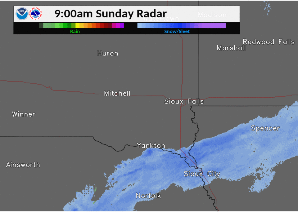
Radar
 |
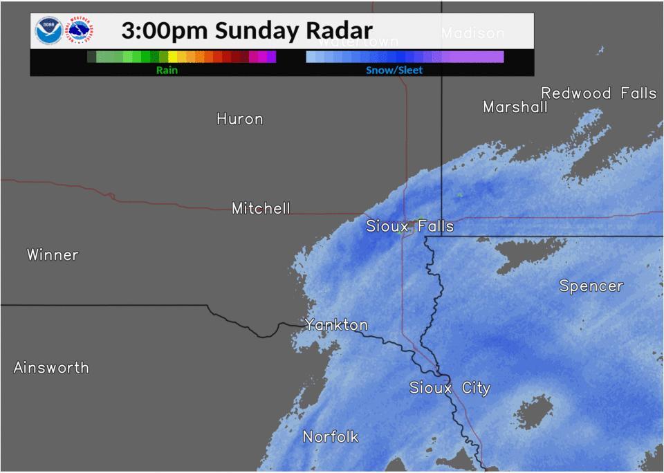 |
| Radar Loop from 900 am - 300 pm CST | Radar Loop from 300 pm - 900 pm CST |
 |
Media use of NWS Web News Stories is encouraged! Please acknowledge the NWS as the source of any news information accessed from this site. |
|


 Weather Story
 Weather Map
 Local Radar