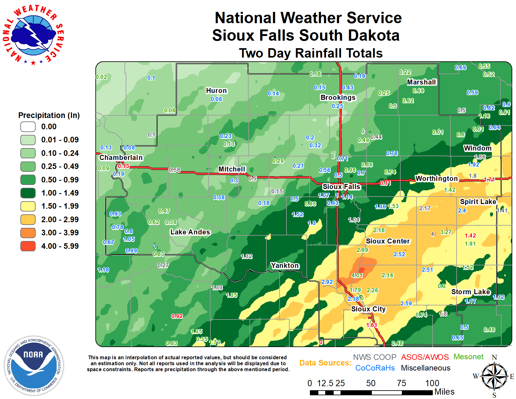
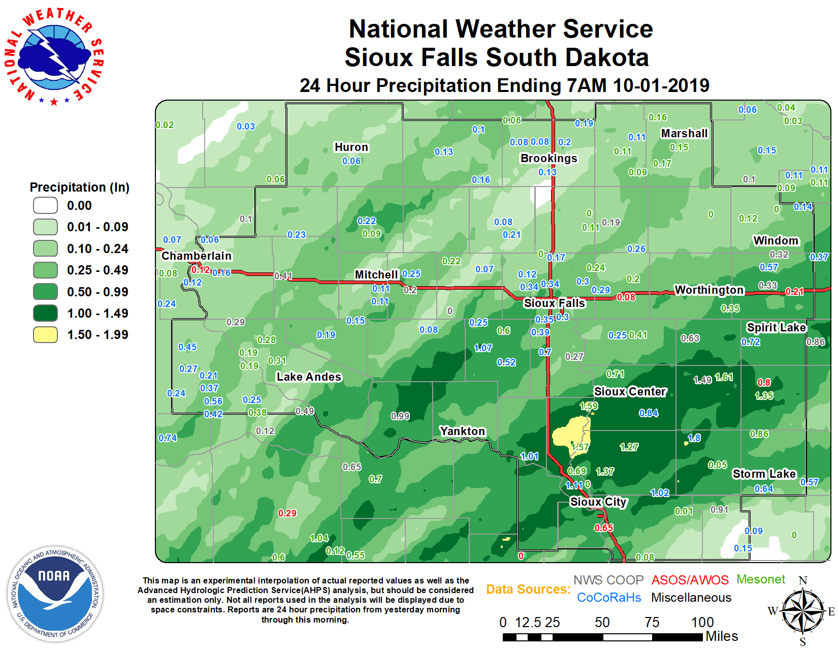
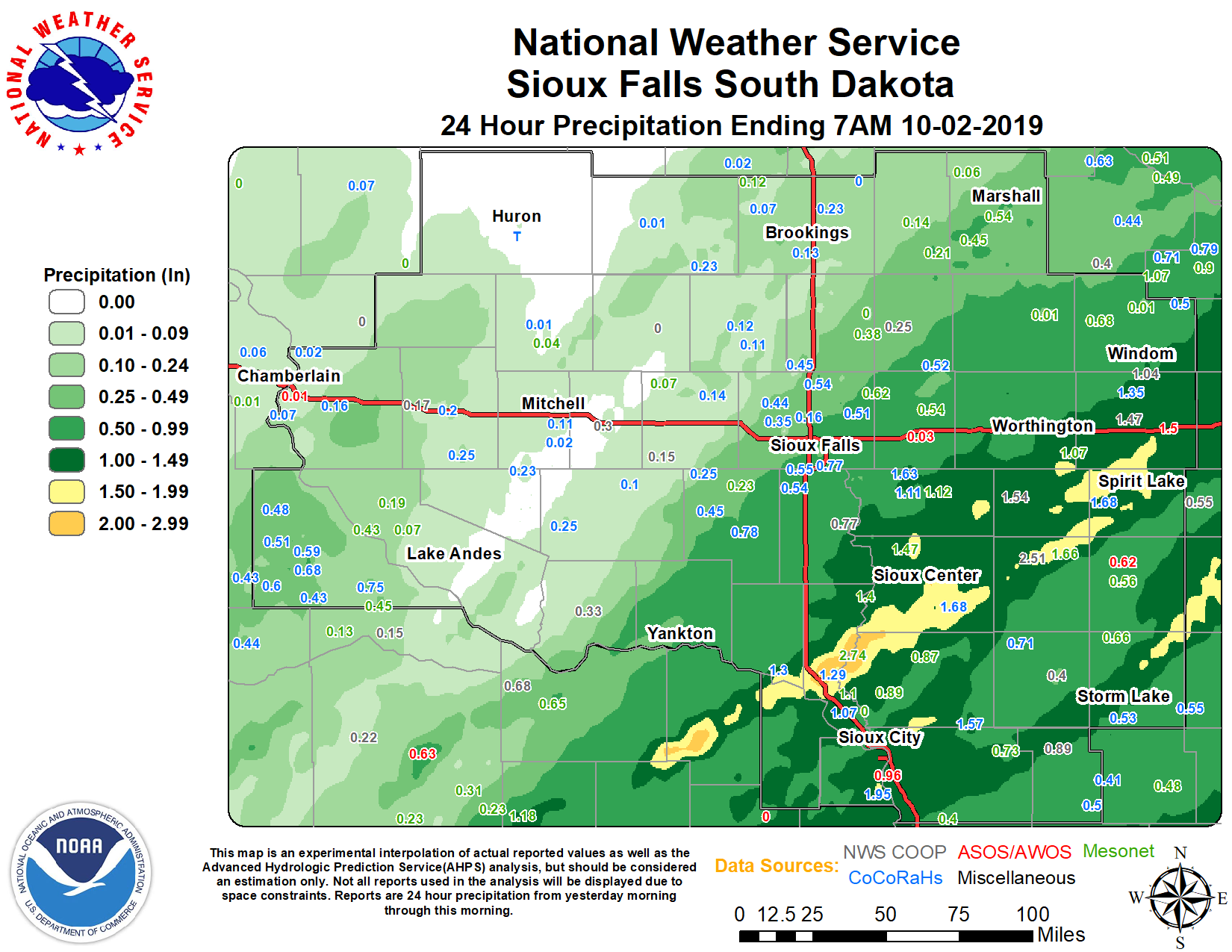
Table of precipitation across southeastern South Dakota, southwestern Minnesota, northwestern Iowa, and extreme
northeastern Nebraska. Observations that are bolded red indicate that the observation was taken during the afternoon
of October 1 and does not include rainfall that after 6 PM October 1, 2019.
Location |
|
24-h PrecipitationOctober 1 |
24-h PrecipitationOctober 2 |
48-h
|
| Sanborn | IA | 1.49 | 2.51 | 4.00 |
| Akron | IA | 1.75 | 1.91 | 3.66 |
| Vermillion 2 SE | SD | 1.16 | 2.50 | 3.66 |
| Sioux Center 2.6 N | IA | 1.84 | 1.74 | 3.58 |
| Sioux Center 0.4 N | IA | 1.45 | 2.12 | 3.57 |
| Orange City | IA | 1.04 | 2.16 | 3.20 |
| Sheldon | IA | 1.37 | 1.56 | 2.93 |
| Vermillion 1.4 SE | SD | 1.06 | 1.86 | 2.92 |
| Elk Point 5.6 NNE | SD | 1.48 | 1.29 | 2.77 |
| Primghar | IA | 0.03 | 2.61 | 2.64 |
| Spirit Lake | IA | 0.75 | 1.86 | 2.61 |
| Kingsley 0.5 S | IA | 1.02 | 1.57 | 2.59 |
| Lake Park 0.2 N | IA | 0.67 | 1.91 | 2.58 |
| Orange City 0.3 ENE | IA | 0.84 | 1.68 | 2.52 |
| Cleghorn 4.4 N | IA | 1.80 | 0.71 | 2.51 |
| Concord | NE | 0.00 | 2.45 | 2.45 |
| Lake Park 3 SSE | IA | 0.72 | 1.68 | 2.40 |
| Vermillion 0.6 SE | SD | 1.01 | 1.30 | 2.31 |
| Jefferson 2.1 WNW | SD | 1.11 | 1.07 | 2.18 |
| Sibley | IA | 0.63 | 1.54 | 2.17 |
| Alta 0.3 SE | IA | 0.73 | 1.37 | 2.10 |
| Lakefield 7.8 N | MN | 0.57 | 1.35 | 1.92 |
| Holstein | IA | 0.91 | 0.89 | 1.80 |
| Lakefield 2 NE | MN | 0.33 | 1.47 | 1.80 |
| Sioux City Airport | IA | 0.04 | 1.59 | 1.63 |
| Rock Rapids | IA | 0.43 | 1.19 | 1.62 |
| Worthington 2 NNE | MN | 0.38 | 1.18 | 1.56 |
| Lester 0.2 E | IA | 0.50 | 1.04 | 1.54 |
| Parker 6.8 WSW | SD | 1.07 | 0.45 | 1.52 |
| Cherokee | IA | 1.09 | 0.40 | 1.49 |
| Spencer Airport | IA | T | 1.42 | 1.42 |
| Windom | MN | 0.32 | 1.04 | 1.36 |
| Yankton 2 E | SD | 0.48 | 0.88 | 1.36 |
| Rock Rapids 5.6 W | IA | 0.25 | 1.11 | 1.36 |
| Tyndall | SD | 0.99 | 0.33 | 1.32 |
| Storm Lake 3.1 S | IA | 0.78 | 0.53 | 1.31 |
| Hurley 0.2 S | SD | 0.52 | 0.78 | 1.30 |
| Menno | SD | 0.00 | 1.29 | 1.29 |
| Sioux Falls 3.4 ESE | SD | 0.42 | 0.77 | 1.19 |
| Sioux Falls 4.0 SE | SD | 0.36 | 0.78 | 1.14 |
| Lennox 3.3 NE | SD | 0.42 | 0.65 | 1.07 |
| Sioux Falls 5.0 SE ARPT | SD | 0.33 | 0.74 | 1.07 |
| Hartford 6.4 S | SD | 0.78 | 0.29 | 1.07 |
| Herrick 4.5 NW | SD | 0.37 | 0.68 | 1.05 |
| Sioux Falls 4.5 SSW | SD | 0.32 | 0.73 | 1.05 |
| Canton | SD | 0.27 | 0.77 | 1.04 |
| Sioux Falls 1.9 SSW | SD | 0.39 | 0.63 | 1.02 |
| Bonesteel 0.1 S | SD | 0.25 | 0.75 | 1.00 |
| Sioux Falls 3.4 WSW | SD | 0.33 | 0.67 | 1.00 |
| Burke 10.5 SSE | SD | 0.56 | 0.43 | 0.99 |
| Sioux Falls 2.6 ESE | SD | 0.30 | 0.69 | 0.99 |
| Wagner 0.8 NW | SD | 0.60 | 0.38 | 0.98 |
| Sioux Falls 3.3 E | SD | 0.30 | 0.66 | 0.96 |
| Sioux Falls NWS | SD | 0.40 | 0.55 | 0.95 |
| Gregory 8.7 N | SD | 0.45 | 0.48 | 0.93 |
| Tea 1.1 NNW | SD | 0.39 | 0.54 | 0.93 |
| Herrick 8.2 SSW | SD | 0.42 | 0.50 | 0.92 |
| Sioux Falls Airport | SD | 0.05 | 0.86 | 0.91 |
| Sioux Falls 3.9 SW | SD | 0.35 | 0.55 | 0.90 |
| Garretson 4.2 SSE | SD | 0.29 | 0.54 | 0.83 |
| Garretson 1.7 WSW | SD | 0.30 | 0.51 | 0.81 |
| Marshall 0.6 S | MN | 0.19 | 0.62 | 0.81 |
| Burke 2.4 NE | SD | 0.21 | 0.59 | 0.80 |
| Gregory 4.3 E | SD | 0.27 | 0.51 | 0.78 |
| Gregory 10.4 S | SD | 0.18 | 0.60 | 0.78 |
| Edgerton 0.5 W | MN | 0.26 | 0.52 | 0.78 |
| Brookings 0.3 SW | SD | 0.50 | 0.25 | 0.75 |
| Edgerton 0.2 WSW | MN | 0.22 | 0.53 | 0.75 |
| Burke 4.2 SW | SD | 0.18 | 0.56 | 0.74 |
| Dell Rapids 0.9 WNW | SD | 0.17 | 0.54 | 0.71 |
| Garretson 0.5 SW | SD | 0.25 | 0.45 | 0.70 |
| Hartford 2.7 NNE | SD | 0.34 | 0.35 | 0.69 |
| Dallas 8.8 S | SD | 0.24 | 0.43 | 0.67 |
| Ghent 2.8 ENE | MN | 0.23 | 0.43 | 0.66 |
| Dante 3.1 S | SD | 0.43 | 0.22 | 0.65 |
| Arthur 3.7 SSW | IA | 0.15 | 0.50 | 0.65 |
| Comfrey 1.6 SW | MN | 0.14 | 0.50 | 0.64 |
| White Lake | SD | 0.41 | 0.17 | 0.58 |
| Colton 3.8 S | SD | 0.12 | 0.44 | 0.56 |
| Marshall | MN | 0.18 | 0.34 | 0.52 |
| Aurora 7.5 N | SD | 0.31 | 0.21 | 0.52 |
| Alexandria | SD | 0.20 | 0.30 | 0.50 |
| Alexandria 6.4 N | SD | 0.25 | 0.25 | 0.50 |
| Renner 4.1 NW | SD | 0.34 | 0.16 | 0.50 |
| Marion 4.8 NNW | SD | 0.25 | 0.25 | 0.50 |
| Pipestone | MN | 0.19 | 0.25 | 0.44 |
| White 1.7 SSW | SD | 0.20 | 0.23 | 0.43 |
| Stickney 3.8 SW | SD | 0.18 | 0.25 | 0.43 |
| Plankinton 3.8 W | SD | 0.20 | 0.20 | 0.40 |
| Oldham 0.9 E | SD | 0.16 | 0.23 | 0.39 |
| Dimock 10.2 W | SD | 0.15 | 0.23 | 0.38 |
| Brookings 0.2 SSW | SD | 0.13 | 0.19 | 0.32 |
| Brookings 5.3 N | SD | 0.11 | 0.21 | 0.32 |
| Pukwana 1.9 S | SD | 0.16 | 0.16 | 0.32 |
| Madison 5.0 SE | SD | 0.21 | 0.11 | 0.32 |
| Brookings 0.5 E | SD | 0.12 | 0.19 | 0.31 |
| Mitchell 6.2 S | SD | 0.24 | 0.06 | 0.30 |
| CHESTER 2N | SD | 0.10 | 0.18 | 0.28 |
| Brookings 1.0 S | SD | 0.12 | 0.13 | 0.25 |
| Forestburg 0.1 NE | SD | 0.22 | 0.01 | 0.23 |
| Bruce 0.2 SSW | SD | 0.08 | 0.15 | 0.23 |
| Mitchell 3.4 SSE | SD | 0.11 | 0.11 | 0.22 |
| Montrose 5.8 NW | SD | 0.07 | 0.14 | 0.21 |
| Madison 0.2 NW | SD | 0.08 | 0.12 | 0.20 |
| Astoria 2.2 SSE | SD | 0.19 | 0.00 | 0.19 |
| Chamberlain 7.5 SSW | SD | 0.12 | 0.07 | 0.19 |
| Emery 10.8 S | SD | 0.08 | 0.10 | 0.18 |
| Bruce 5.3 W | SD | 0.08 | 0.07 | 0.15 |
| Bridgewater | SD | 0.00 | 0.15 | 0.15 |
| Lake Andes 2.4 N | SD | 0.06 | 0.08 | 0.14 |
| De Smet 0.2 SSE | SD | 0.13 | 0.01 | 0.14 |
| Lake Preston 10.5 NNE | SD | 0.10 | 0.04 | 0.14 |
| Mitchell 7.3 S | SD | 0.11 | 0.02 | 0.13 |
| Iroquois | SD | T | 0.09 | 0.09 |
| Huron 1.1 NNE | SD | 0.03 | 0.05 | 0.08 |
| Chamberlain 7.5 NNE | SD | 0.06 | 0.02 | 0.08 |
| Howard | SD | 0.07 | T | 0.07 |
| Chamberlain 0.3 W | SD | 0.05 | 0.02 | 0.07 |
| Huron 6.8 NNE | SD | 0.06 | 0.01 | 0.07 |
| Huron 1.3 S | SD | 0.06 | T | 0.06 |
| Huron Airport | SD | T | 0.04 | 0.04 |
| Mitchell Airport | SD | T | T | T |


 Weather Story
 Weather Map
 Local Radar