Overview
|
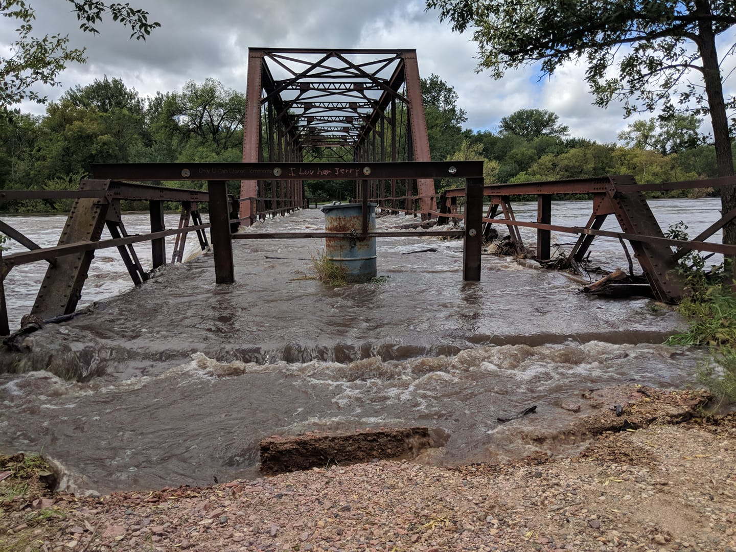
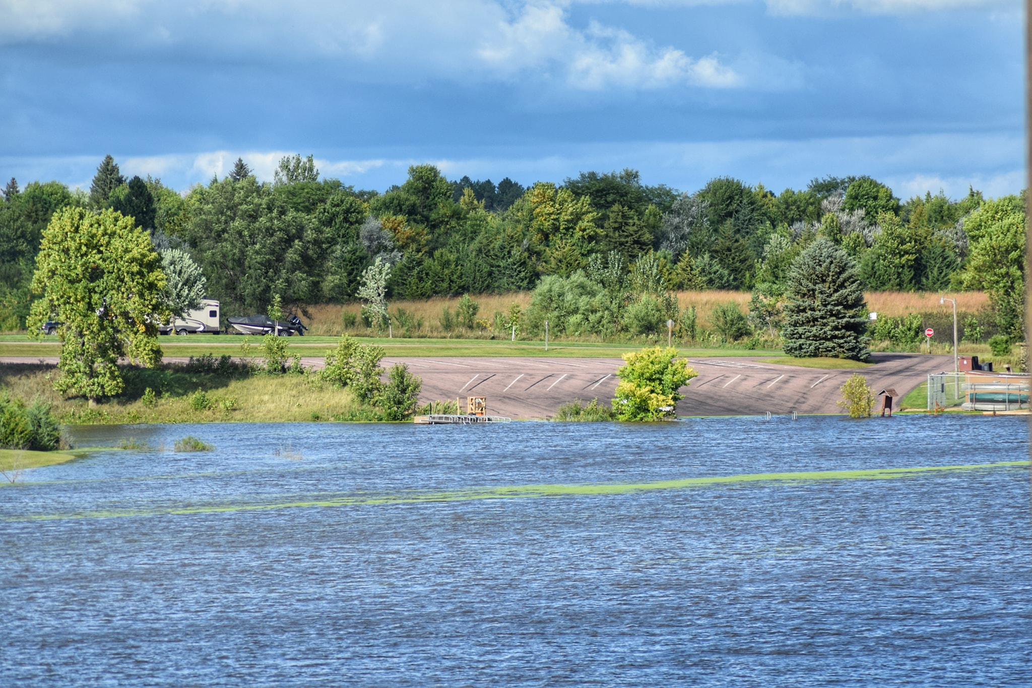
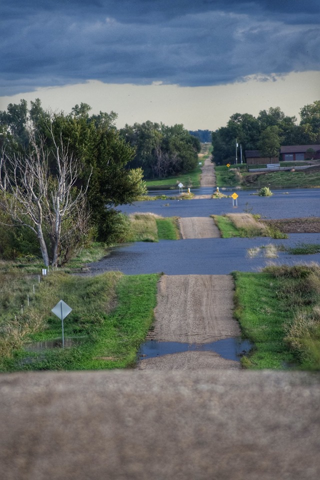
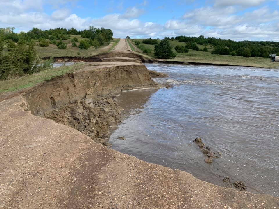
Slow moving, repeat thunderstorms produced widespread heavy rainfall across portions of southeast South Dakota into southwest Minnesota the evening of Wednesday, September 11th into the early morning hours of Thursday, September 12th. Rainfall amounts across a large area ranged from 3 to 8 inches. Looking at the 48 hour rainfall totals from late Tuesday September 10th through the morning of Thursday, September 12th, a band of extreme rainfall fell from Mitchell, SD to Madison, SD to Slayton, MN, where 6 to 12 inches accumulated. This rainfall resulted in significant flash flooding, requiring evacuations in some communities and many water rescues. As the water moved into the river system, major to record flooding occurred at numerous locations. Many structures were inundated with water. In addition, damage to area roads was significant and widespread. Of note, Interstate 90 from Sioux Falls to Mitchell, SD was closed for an extended period due to flooding. Updates will be posted as additional information becomes available. |
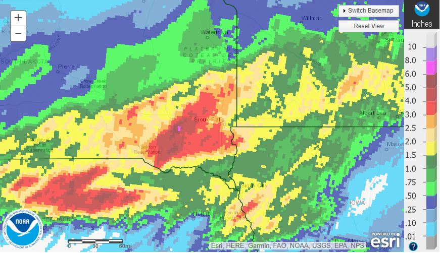
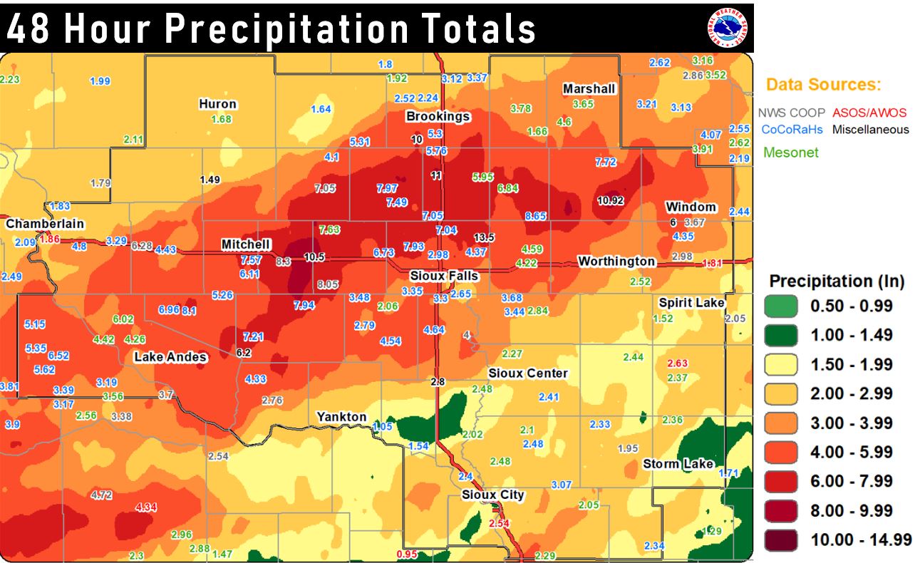 48 Hour Rainfall Ending September 12, 2019 |
Flooding
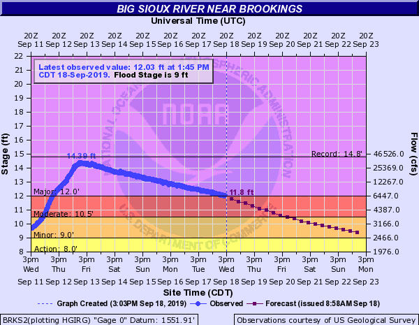
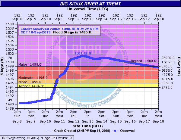
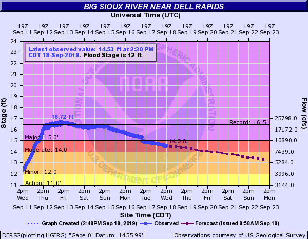
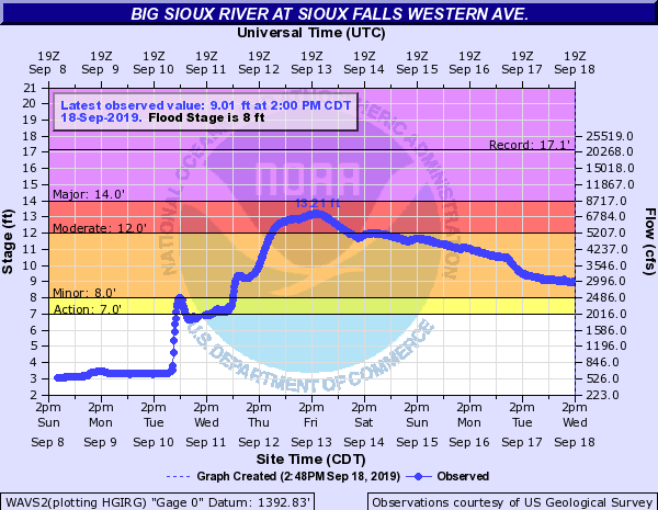
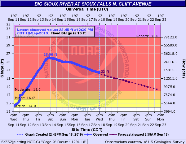
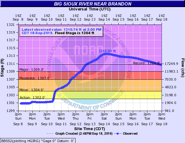
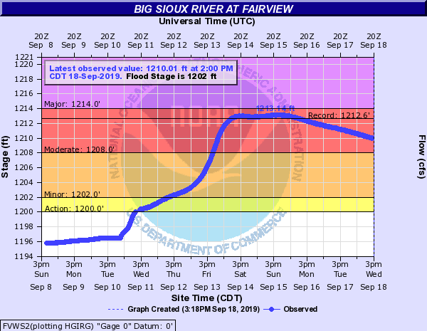
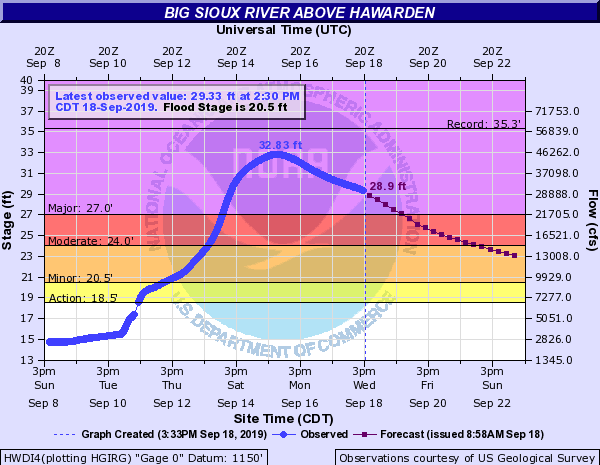
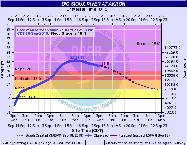
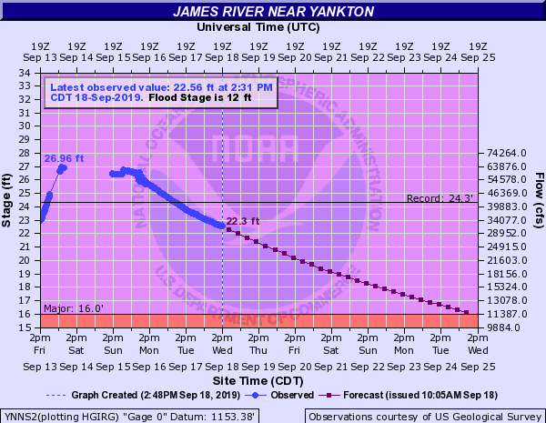
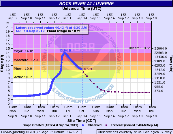
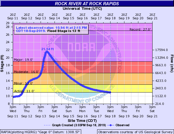
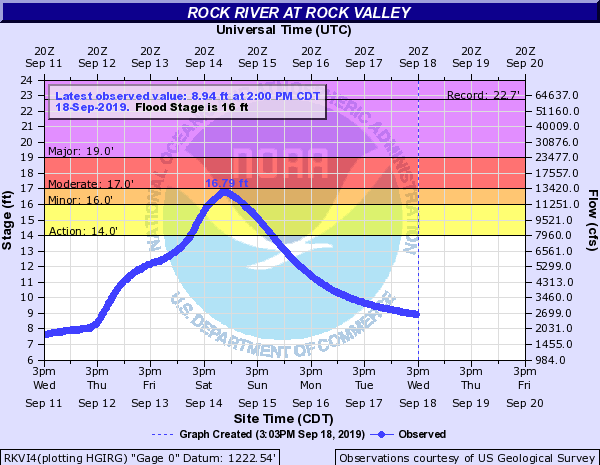
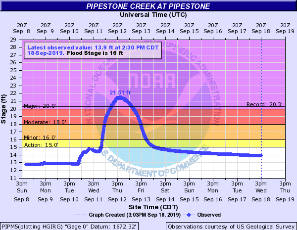
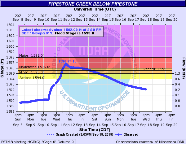
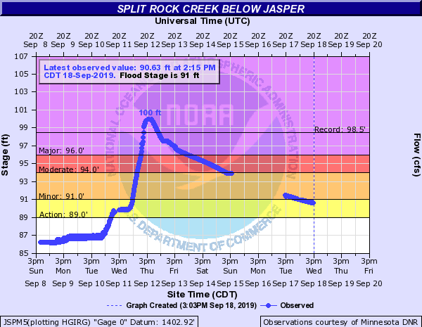
Major to record flooding occurred on the Big Sioux, Vermillion, James, and Rock Rivers. Major to record flooding also occurred on Pipestone and Split Rock Creeks.
Hydrographs
 |
 |
 |
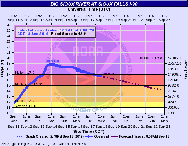 |
| Big Sioux River near Brookings | Big Sioux River at Trent | Big Sioux River near Dell Rapids | Big Sioux River at Sioux Falls I-90 |
 |
 |
 |
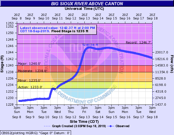 |
| Big Sioux River at Western Avenue | Big Sioux River at North Cliff | Big Sioux River near Brandon | Big Sioux River above Canton |
 |
 |
 |
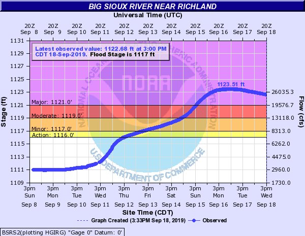 |
| Big Sioux River at Fairview | Big Sioux River above Hawarden | Big Sioux River at Akron | Big Sioux River near Richland |
.png) |
.png) |
 |
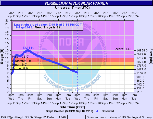 |
| James River near Mitchell | James River near Scotland | James River near Yankton | Vermillion River near Parker |
 |
 |
 |
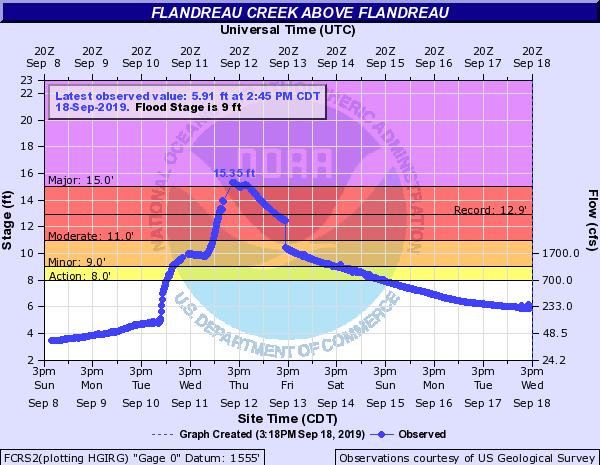 |
| Rock River at Luverne | Rock River at Rock Rapids | Rock River at Rock Valley | Flandreau Creek above Flandreau |
 |
 |
 |
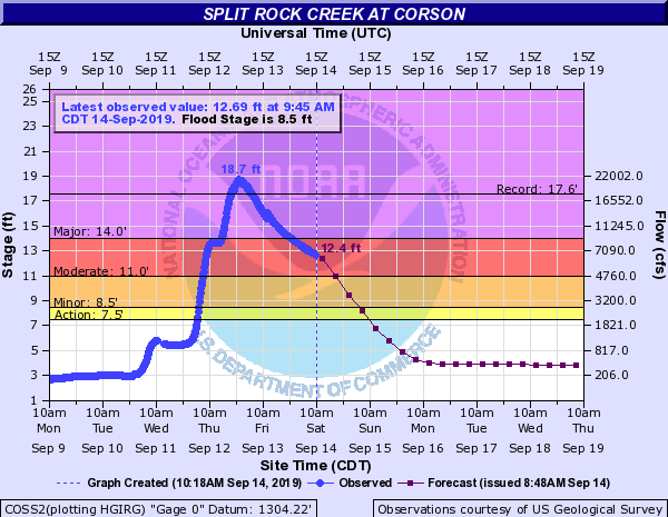 |
| Pipestone Creek at Pipestone | Pipestone Creek below Pipestone | Split Rock Creek below Jasper | Split Rock Creek at Corson |
| Caption | Caption | Caption | Caption |
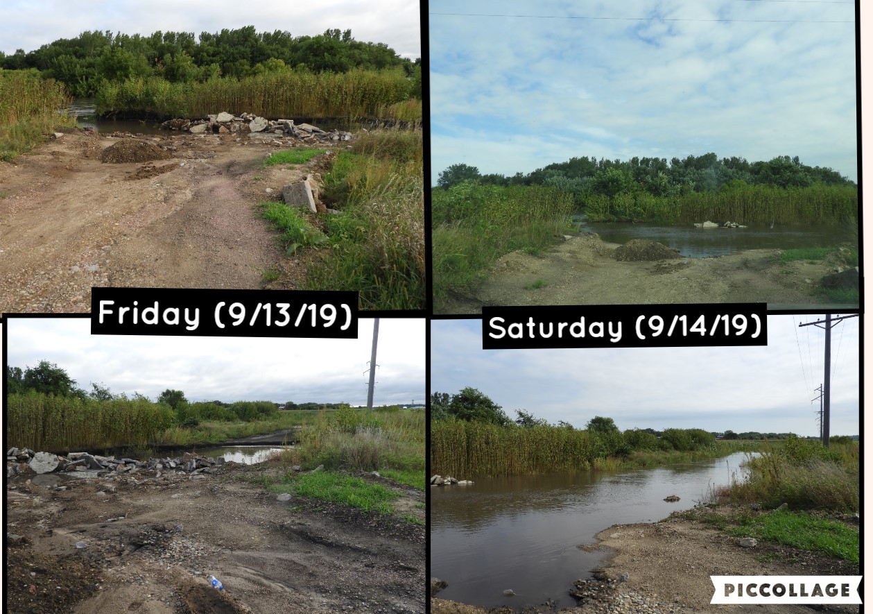
Photos
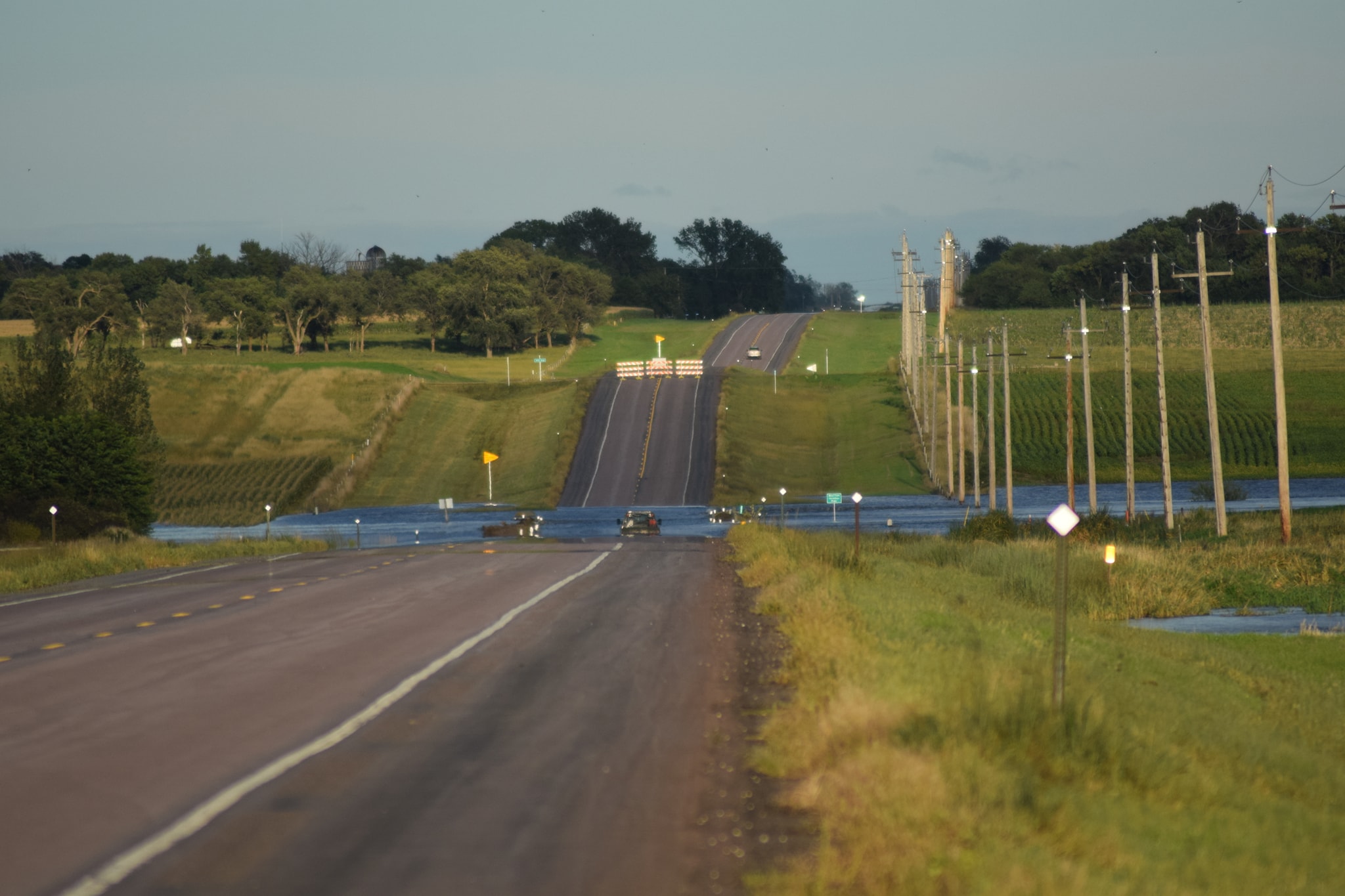 |
 |
 |
 |
| Vermillion West Fork River on Hwy 42 (Sereh Rose) |
Big Sioux River at Klondike, IA Bridge (Paige Stensland) |
Lake Vermillion Boat Launch (Sereh Rose) |
Rural Road near Dalton, SD (Sereh Rose) |
 |
 |
.jpg) |
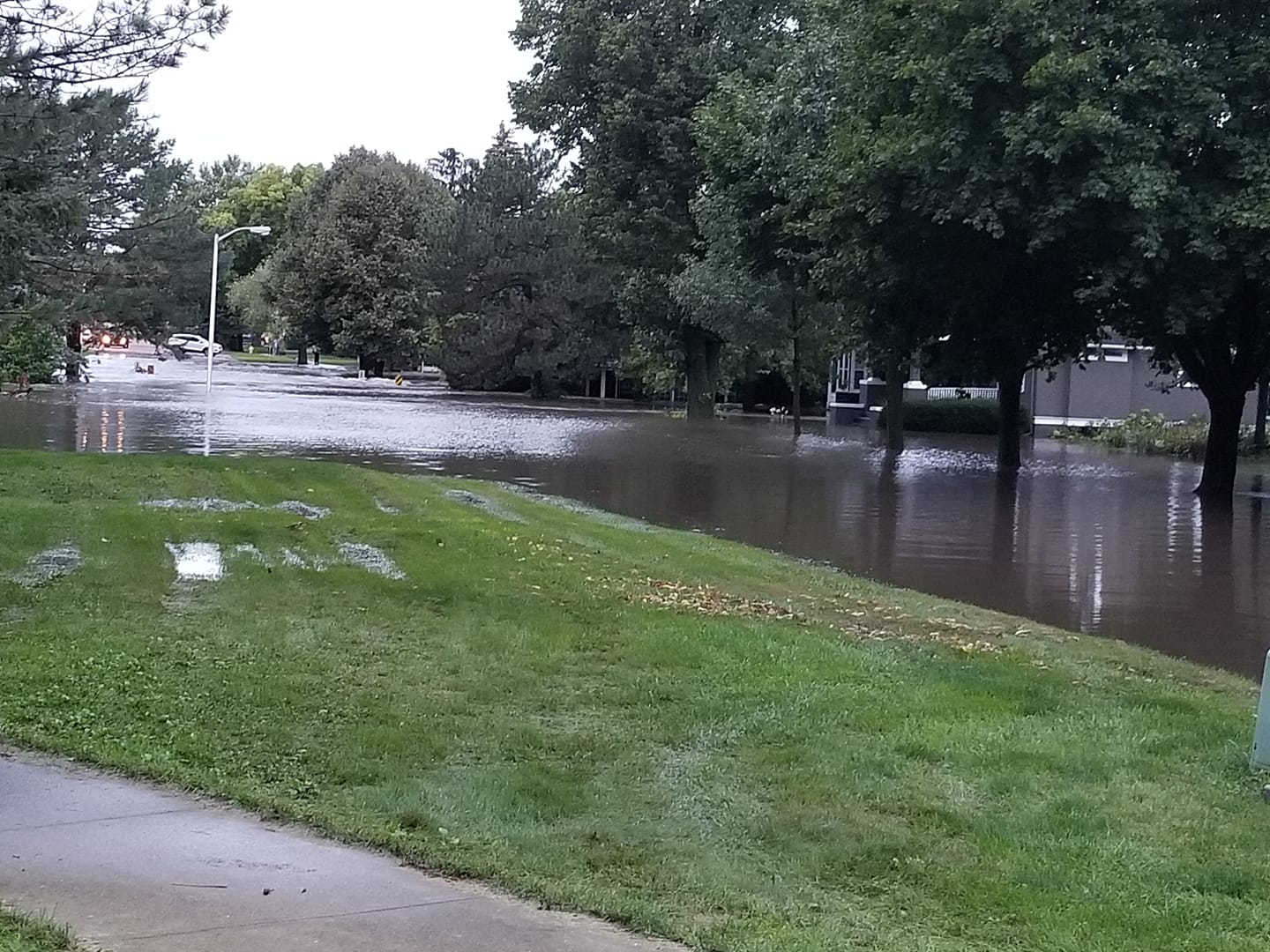 |
| Enemy Creek 4S Mitchell, SD (Carolyn Guthrie) |
Rock River at US Hwy 18 (Andrew Boender) |
Railroad Bridge at Dell Rapids, SD (Tarah Buggraff) |
Flooding in Madison, SD (Tricia Brands) |
 |
.jpg) |
.jpg) |
.jpg) |
| Pipestone Creek at 245th & Hwy 11 (Pam Shellum) |
Falls Park Sioux Falls, SD (NWS) |
Falls Park Sioux Falls, SD (NWS) |
Pipestone Creek in Pipestone, MN (NWS) |
.jpg) |
.jpg) |
.JPG) |
 |
| Pipestone Creek near Pipestone, MN (NWS) |
Split Rock Creek near Sherman, MN (NWS) |
Split Rock Creek near Jasper, MN (NWS) |
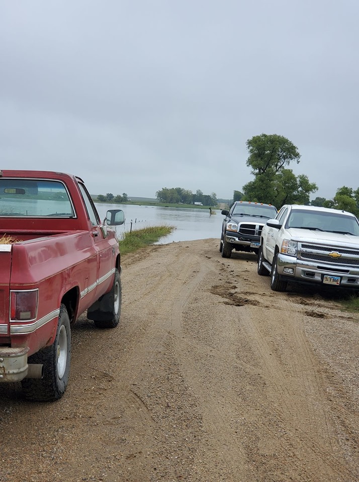
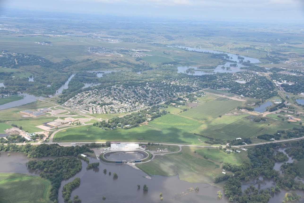
Brandon, SD (SD Civil Air Patrol) |
.JPG) |
.JPG) |
.JPG) |
.JPG) |
| Spencer, SD (SD Civil Air Patrol) |
James River near Mitchell, SD (SD Civil Air Patrol) |
Big Sioux River at Interstate 90 (SD Civil Air Patrol) |
60th Street Sioux Falls, SD (SD Civil Air Patrol) |
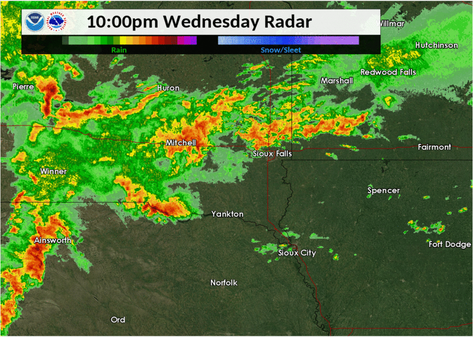
Radar
 |
 |
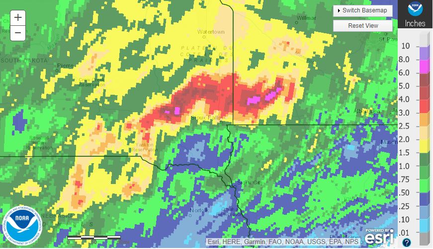 |
| Radar Loop from 10 PM September 11th to 4 AM September 12th | 24 Hour Radar Rainfall Estimate Ending 7 AM September 11, 2019 | 24 Hour Radar Rainfall Estimate Ending 7 AM September 12, 2019 |
Rain Reports
666
NOUS43 KFSD 121657
PNSFSD
IAZ001>003-012>014-020>022-031-032-MNZ071-072-080-081-089-090-097-098-NEZ013-
014-SDZ038>040-050-052>071-130457-

Public Information Statement
National Weather Service Sioux Falls SD
1157 AM CDT Thu Sep 12 2019

...TWO DAY PRECIPITATION REPORTS ENDING THURSDAY MORNING...

Location                     Amount
6 NNE Coleman                11.00 in
Avoca                        10.92 in
North Branch Pipestone Creek 10.80 in
Pipestone Creek              10.65 in
6 E Sinia                    10.00 in
1 W Mitchell                 9.49 in
Skunk Creek                  9.24 in
Edgerton 0.5 W               9.08 in
Edgerton 0.2 WSW             8.86 in
Chester 2n                   8.81 in
Pipestone Creek              8.41 in
Emery 10.8 S                 8.14 in
Madison 5.0 SE               7.67 in
Mitchell 6.2 S               7.61 in
Mitchell 3.4 SSE             7.59 in
Brookings 10 SE              7.20 in
Redstone RAWS                7.12 in
Pipestone Raws               7.10 in
Mitchell Municipal Airport   7.09 in
Willow Creek                 7.02 in
Parkston 6.5 WSW             6.78 in
Montrose 2.4 E               6.78 in
Skunk Creek                  6.74 in
Rock River                   6.71 in
Split Rock Creek             6.58 in
Burke 2.4 NE                 6.55 in
Howard 5.3 W                 6.53 in
White Lake                   6.49 in
Mitchell                     6.41 in
Redwood River                6.39 in
Redwood River                6.38 in
5 N Mt Vernon                6.35 in
Aurora 0.3 NE                6.32 in
Academy 2 NE                 6.31 in
4 W Tripp                    6.22 in
Brookings 0.5 E              6.19 in
Flandreau                    6.15 in
Mitchell 7.3 S               6.15 in
Brookings 8.1 S              6.03 in
Brookings 1.4 SW             5.96 in
Oldham 0.9 E                 5.77 in
Stickney 3.8 SW              5.68 in
Burke 4.2 SW                 5.65 in
Luverne                      5.54 in
Marshall 0.6 S               5.53 in
Lake Andes 2.4 N             5.51 in
Dimock 10.2 W                5.32 in
Sioux Falls Western Avenue   5.21 in
Gregory 8.7 N                5.17 in
Oldham 1.9 ENE               5.13 in
Wall Lake Precipitation      5.13 in
James River                  5.11 in
Brookings 0.2 SSW            4.95 in
Aurora 7.5 N                 4.94 in
Eros Data Center             4.91 in
Brookings 2 NE               4.74 in
Lakefield 7.8 N              4.68 in
White 1.7 SSW                4.59 in
Hurley 0.2 S                 4.59 in
Howard 10.3 NNE              4.54 in
Brookings Municipal Airport  4.53 in
Garretson 4.2 SSE            4.35 in
Marshall Municipal Airport   4.17 in
Sioux Falls NWS              4.08 in
Astoria 2.2 SSE              3.93 in
Sioux Falls 3.3 E            3.69 in
Sioux Falls 3.9 SW           3.66 in
E.fork Vermillion Rvr        3.66 in
Sioux Falls Airport          3.64 in
Perry Creek                  3.62 in
White 0.4 WNW                3.62 in
Marion 4.8 NNW               3.59 in
Ocheyedan River              3.56 in
Sioux Falls 4.5 SSW          3.53 in
Tea 1.1 NNW                  3.53 in
Kimball 3.9 ENE              3.49 in
Worthington 2 NNE            3.48 in
Rock River                   3.44 in
Renner 4.1 NW                3.42 in
Brookings 5.3 N              3.31 in
Sioux Falls 3ese             3.27 in
Kingsley 0.5 S               3.27 in
Sioux Falls 5.0 SE ARPT      3.27 in
Bruce 5.3 W                  3.20 in
Millnerville                 3.19 in
Lakefield 2 NE               3.11 in
Sioux Falls 4.0 SE           3.10 in
L. Sioux River               2.95 in
Sioux Falls Harmondon Park   2.89 in
W Fork Ditch                 2.86 in
Sioux City Perry Creek       2.84 in
Arthur 3.7 SSW               2.80 in
Rock River                   2.80 in
Worthington Airport          2.79 in
Pukwana 1.9 S                2.75 in
Spencer Municipal Airport    2.72 in
Lake Park 0.2 N              2.69 in
Jefferson 2.1 WNW            2.65 in
Spirit Lake                  2.59 in
Sioux Gateway Airport        2.56 in
Sioux Falls Oak View Library 2.56 in
Bruce 0.2 SSW                2.53 in
Cleghorn 4.4 N               2.38 in
Lake Park 3.2 SSE            2.37 in
Sioux Center 2.6 N           2.36 in
De Smet 0.2 SSE              2.36 in
Sibley                       2.33 in
Huron 6.8 NNE                2.25 in
Floyd River                  2.19 in
Floyd River                  2.16 in
Cherokee                     2.16 in
Hitchcock 7.5 WSW            2.07 in
Huron Regional Airport       2.05 in
Emerson                      1.95 in
Forestburg 0.1 NE            1.95 in
Chamberlain 0.3 W            1.93 in
North Cliff-Big Sioux R      1.93 in
Chamberlain 7.5 NNE          1.89 in
Little Sioux River           1.76 in
Vermillion 1.4 SE            1.55 in
Jackson Airport              1.50 in
Alta 0.3 SE                  1.48 in
Cherokee Municipal Airport   1.46 in
Windom Municipal Airport     1.34 in
Yankton 2 E                  1.21 in
Gayville 1.8 SSW             1.07 in
Des Moines River             0.95 in

Observations are collected from a variety of sources with varying
equipment and exposures. We thank all volunteer weather observers
for their dedication. Not all data listed are considered official.

$$
 |
Media use of NWS Web News Stories is encouraged! Please acknowledge the NWS as the source of any news information accessed from this site. |
|


 Weather Story
 Weather Map
 Local Radar