Overview
|
A strong arctic front Sunday night into early Monday was ushered in by very strong wind, at times over 60 mph. While very few cold temperature records were sent, the air mass was the coldest in the last 10 to 20 years across the region. Temperature in many locations fell below zero late Monday night and did not rise above zero until Thursday morning. The coldest day of the period was on January 30 when many locations had wind chills form -40 to -60°F. Daytime temperatures were between -10°-0°F. |
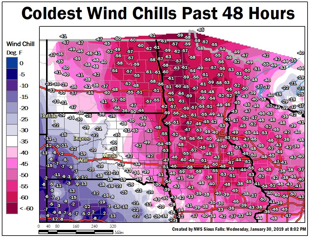 Coldest Wind Chill Values for January 30-31, 2019 |
Wind/Frontal Passage:
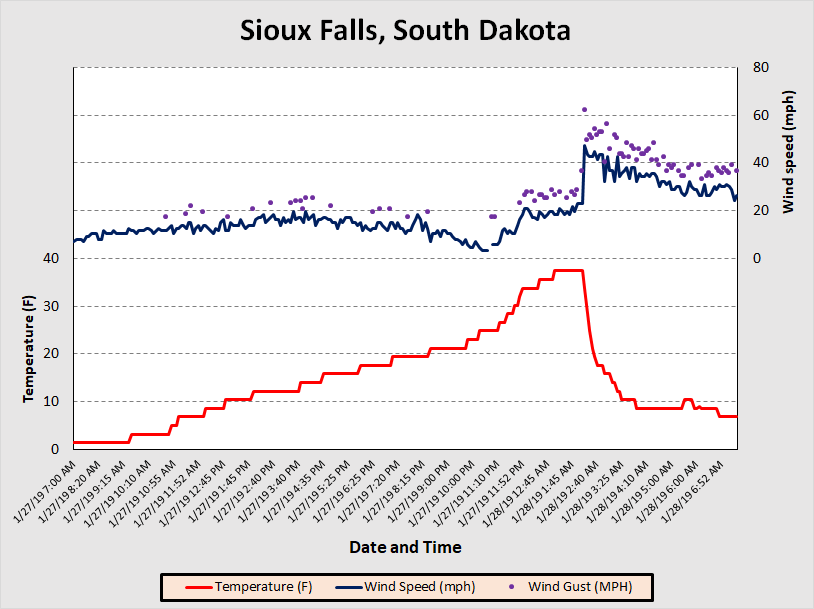
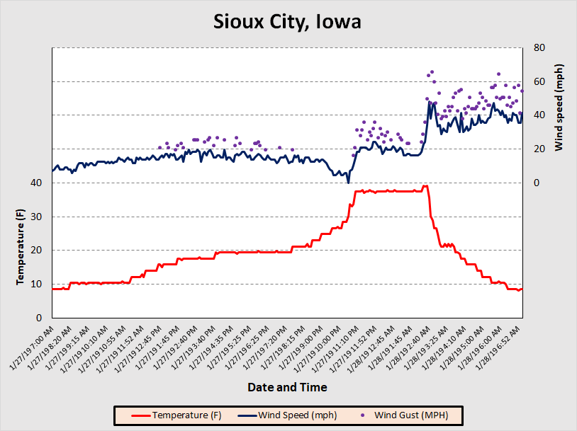
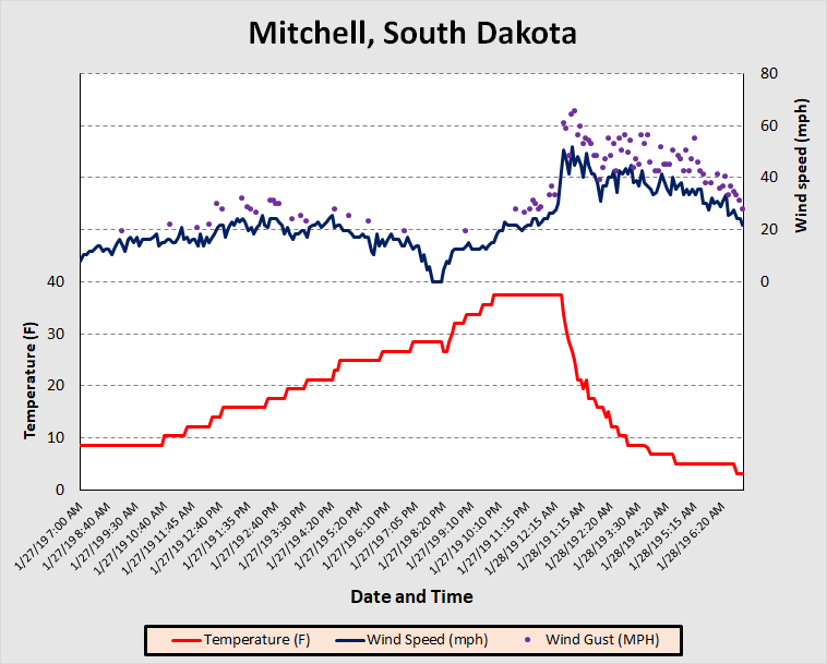
A strong arctic front moved across South Dakota, Minnesota, and Iowa Sunday night. The front resulted in a temperature fall of 15 to 20 degrees in an hour in parts of eastern South Dakota as winds gusted over 60 mph..
Frontal Passage
Wind and temperatures observations for Sunday evening into Monday morning showing the strong frontal passage.
 |
 |
 |
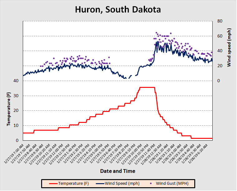 |
| Sioux Falls, South Dakota | Sioux City, Iowa | Mitchell, South Dakota | Huron, South Dakota |
Peak Wind Gusts
Peak wind gusts during Sunday night into Monday morning.
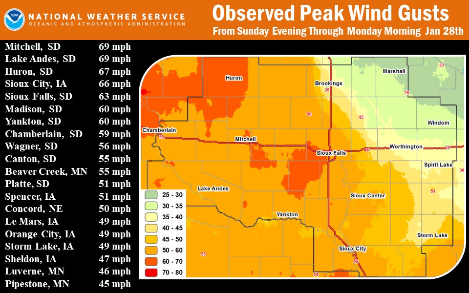 |
| Peak observed wind gust Evening of January 27 thru the morning of January 28 |
Wind Chills
Coldest wind chill values, most of which occurred Wednesday night into early Thursday morning.
|
                                     Location                    Wind Chill Time/Date       Provider
                                     Windom Muni Airport          -60 F     1155 PM 01/29   AWOS
                                     Marshall Municipal Airport   -59 F     1156 PM 01/29   AWOS
                                     Jackson Airport              -58 F     1236 AM 01/30   AWOS
                                     Worthington Airport          -58 F     0356 AM 01/30   AWOS
                                     Tracy Airport                -55 F     0215 AM 01/30   AWOS
                                     Brookings Municipal Airport  -54 F     0856 PM 01/29   AWOS
                                     Madison Airport              -53 F     1055 PM 01/29   AWOS
                                     Pipestone Airport            -53 F     1235 AM 01/30   AWOS
                                     Storm Lake Airport           -53 F     1115 PM 01/29   AWOS
                                     Sheldon Airport              -52 F     0935 PM 01/29   AWOS
                                     Luverne Airport              -51 F     0556 AM 01/30   AWOS
                                     Spencer Municipal Airport    -51 F     0253 AM 01/30   ASOS
                                     Huron Regional Airport       -49 F     0255 AM 01/30   ASOS
                                     Sioux Falls Airport          -47 F     1056 PM 01/29   ASOS
                                     Cherokee Municipal Airport   -46 F     1035 PM 01/29   AWOS
                                     Le Mars Airport              -46 F     1135 PM 01/29   AWOS
                                     Orange City Airport          -46 F     0415 AM 01/30   AWOS
                                     Sioux Gateway Airport        -43 F     1152 PM 01/29   ASOS
                                     Mitchell Municipal Airport   -42 F     1153 PM 01/29   ASOS
                                     Yankton Municipal Airport    -41 F     0256 AM 01/30   AWOS
                                     Chamberlain Municipal Airpor -32 F     0935 PM 01/29   AWOS
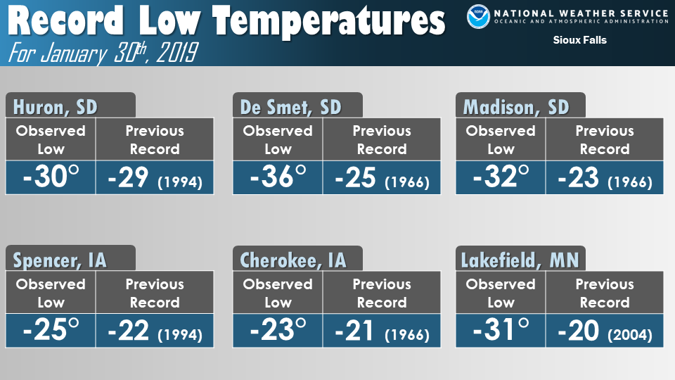
Temperature Records
 |
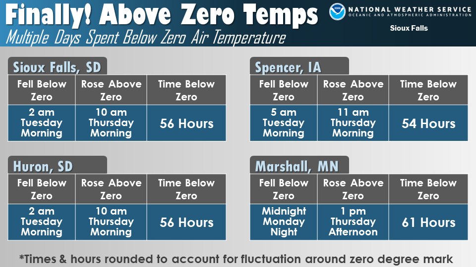 |
| Record lows for the morning of January 30th. | Time spent below zero degrees from January 28th thru February 1st. |
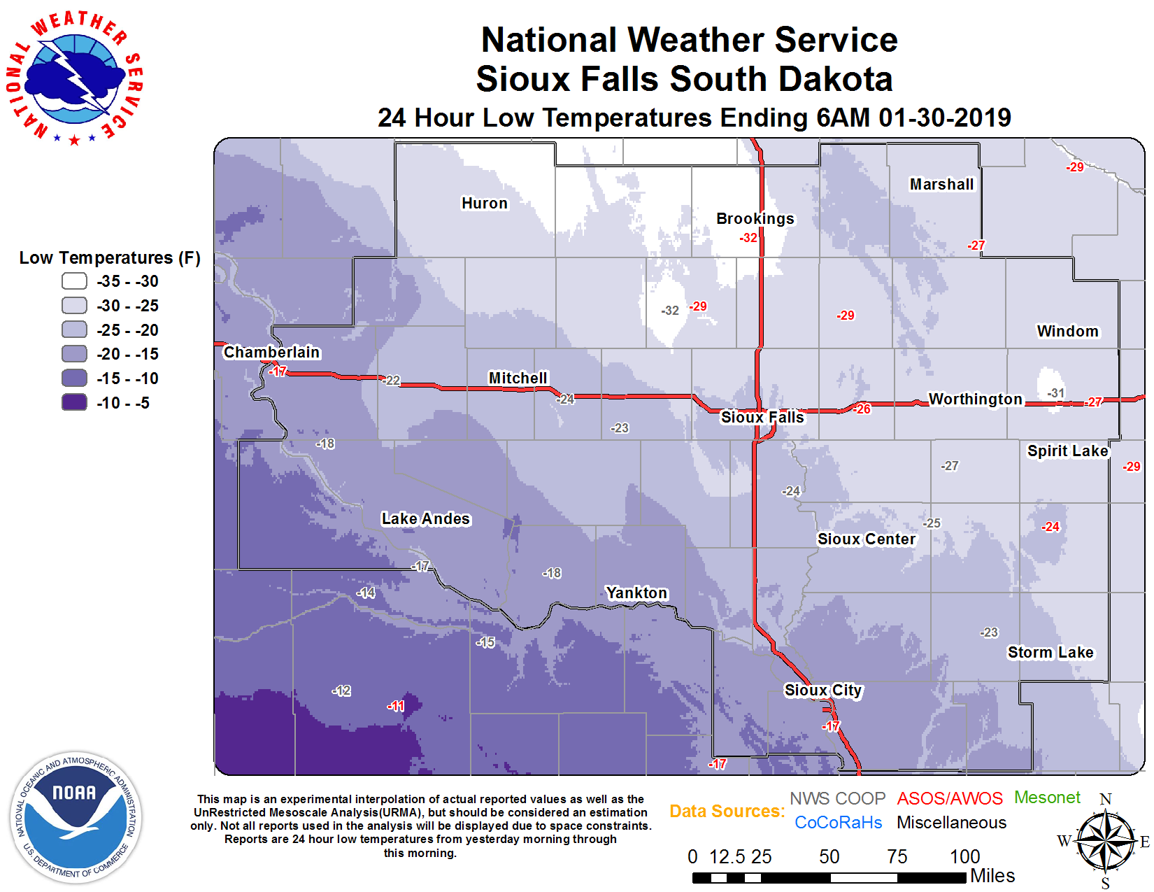 |
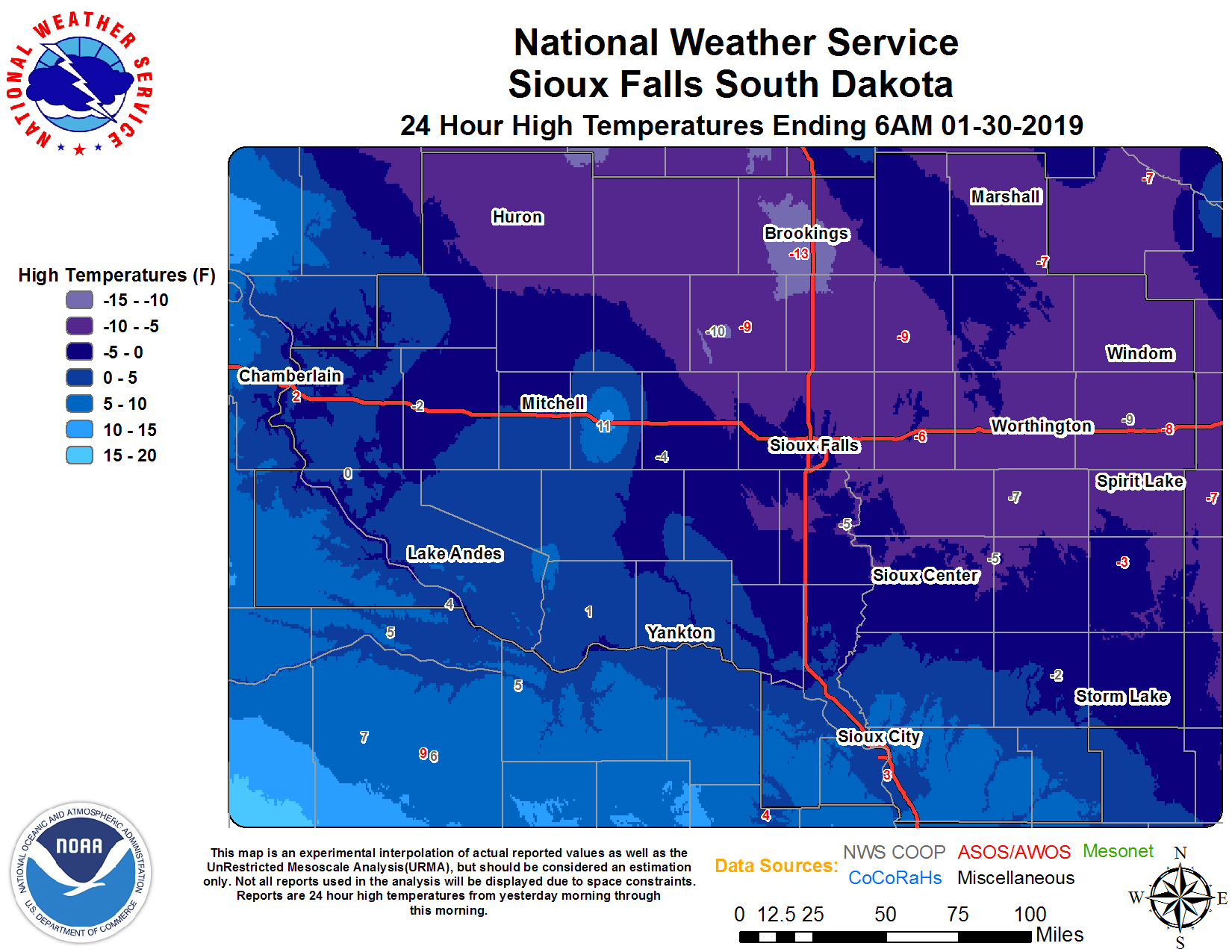 |
| January 31, 2019 Low Temperature | January 31, 2019 High Temperature |
 |
Media use of NWS Web News Stories is encouraged! Please acknowledge the NWS as the source of any news information accessed from this site. |
|


 Weather Story
 Weather Map
 Local Radar