Overview
|
A band of heavy snow developed just north of Interstate 90 during the morning of Friday, January 18, 2019. The axis of heaviest snow, with reports of 10 to 15 inches, was along the SD Hwy 34/MN Hwy 30 corridor from around Madison, SD, east toward Windom, MN. Despite not being within the heaviest snow band, new daily snowfall records were set at both Sioux Falls and Huron, South Dakota. |
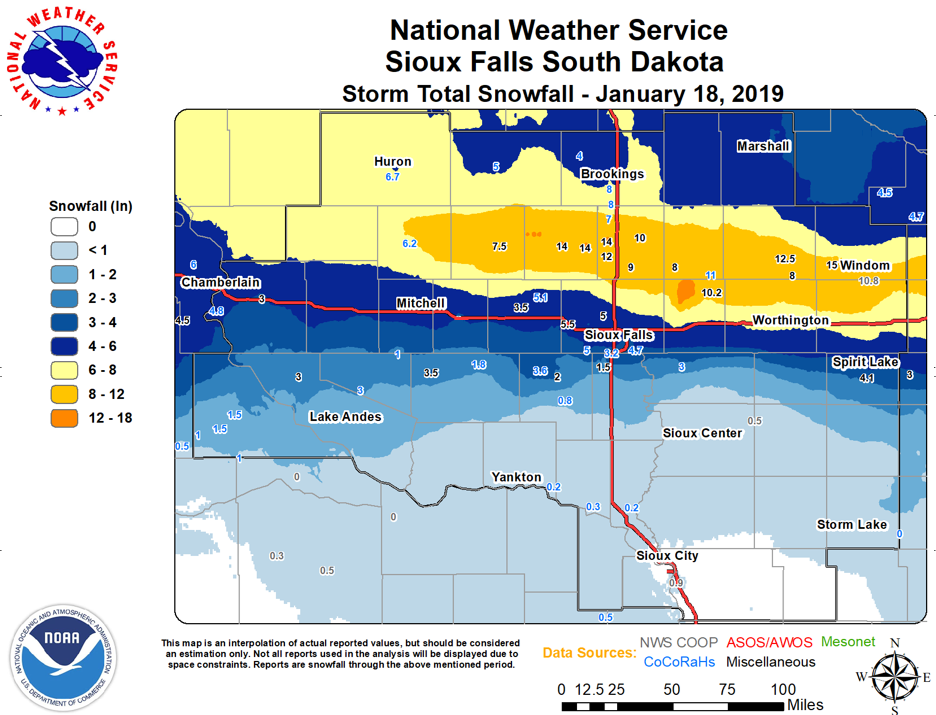 Observed Storm Total Snowfall Map for January 18, 2019 |
 |
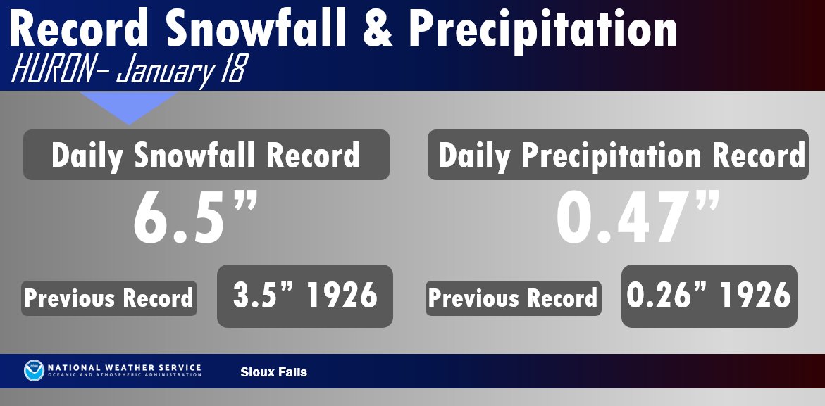 |
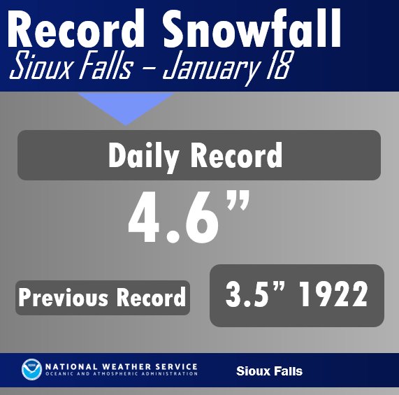
| Sioux Falls set a new daily record for snowfall | Huron set 2 records, one for daily snowfall, and the other for daily precipitation (liquid equivalent) |
Snow/Ice
...SNOWFALL REPORTS FOR JANUARY 18 2019...

Location                     Amount    Time/Date       Provider
8 S Storden                  15.0 in   0545 PM 01/18   Public
Wentworth                    14.0 in   0245 PM 01/18   Public
3 N Colman                   14.0 in   0525 PM 01/18   Public
Madison                      14.0 in   0630 PM 01/18   Public
Avoca                        12.5 in   0400 PM 01/18   Public
2 S Colman                   12.0 in   0400 PM 01/18   Public
2 E Madison                  11.7 in   0900 AM 01/19   COOP
Windom                       10.8 in   0700 AM 01/19   CO-OP Observer
3 ENE Hardwick               10.2 in   0417 PM 01/18   Public
Chester 2n                   10.2 in   0700 AM 01/19   COOP
Flandreau                    10.0 in   0300 PM 01/18   Public
2 N Chester                  9.8 in    0700 AM 01/19   CO-OP Observer
Trent                        9.0 in    0206 PM 01/18   Public
Edgerton                     8.0 in    0126 PM 01/18   Public
Pipestone                    8.0 in    0150 PM 01/18   Newspaper
Heron Lake                   8.0 in    0315 PM 01/18   Public
Howard                       7.5 in    1257 PM 01/18   Public
Brookings                    7.5 in    0245 PM 01/18   Public
De Smet                      7.5 in    0738 PM 01/18   Public
1 NE Baltic                  6.8 in    0457 PM 01/18   Public
Huron                        6.5 in    0855 AM 01/19   Official NWS Obs
Wolsey                       6.0 in    0450 PM 01/18   Public
2 NE Worthington             6.0 in    0700 AM 01/19   CO-OP Observer
6 S Oacoma                   5.7 in    0700 AM 01/19   COCORAHS
Brookings                    5.7 in    0700 AM 01/19   COCORAHS
Humboldt                     5.5 in    0800 PM 01/18   Public
5 W Bruce                    5.0 in    0800 AM 01/19   COCORAHS
Wall Lake                    5.0 in    0900 AM 01/19   COCORAHS
4 WSW Sioux Falls            4.8 in    0700 AM 01/19   CO-OP Observer
3 N Sioux Falls              4.6 in    0600 AM 01/19   Official NWS Obs
2 NE Brookings               4.5 in    0800 AM 01/19   COOP
Spirit Lake                  4.1 in    0700 AM 01/19   CO-OP Observer
3 ESE Sioux Falls            3.9 in    0700 AM 01/19   CO-OP Observer
Marion                       3.6 in    0700 AM 01/19   COOP
3 SSE Sioux Falls            3.2 in    0700 AM 01/19   CO-OP Observer
3 SW Sioux Falls             3.2 in    0700 AM 01/19   COCORAHS
2 NE Academy                 2.0 in    0900 AM 01/19   COOP
Clayton                      1.8 in    0600 AM 01/19   COCORAHS
4 SW Burke                   1.5 in    0700 AM 01/19   COCORAHS
2 WNW Sergeant Bluff         0.9 in    0600 AM 01/19   Official NWS Obs
2 E Yankton                  0.5 in    0700 AM 01/19   CO-OP Observer
Sheldon                      0.5 in    0700 AM 01/19   COOP
Tyndall                      0.5 in    0800 AM 01/19   COOP
Remsen No. 2                 0.4 in    1100 AM 01/19   COOP
Orange City                  0.2 in    0700 AM 01/19   COOP
2 W Westfield                0.2 in    0800 AM 01/19   COCORAHS

Observations are collected from a variety of sources with varying
equipment and exposures. We thank all volunteer weather observers
for their dedication. Not all data listed are considered official.

$$
Radar
Loops and static images
 |
 |
|
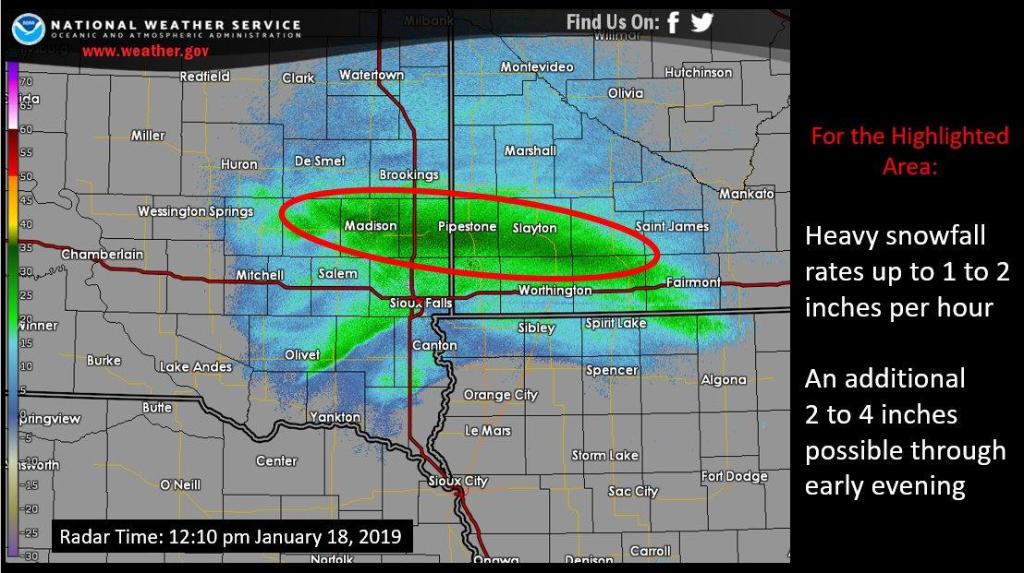
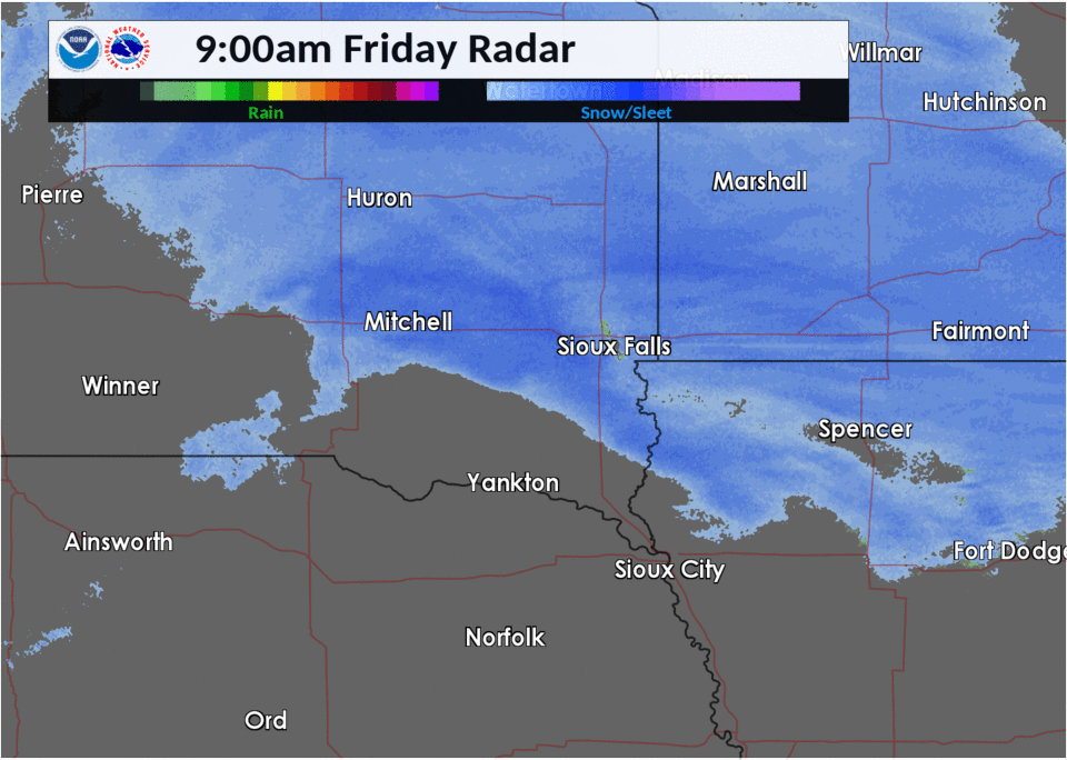
| Midday Radar Image showing location of heavy snow band producing 1-2 inch per hour snowfall rates. |
Midday Radar Loop showing the heavy snow band develop just north of Interstate 90. |
Regional Radar Loop from
2 am Friday through 3 am Saturday.
Additional Info
Why did some see a foot of snow on Friday and others minimal amounts?
— NWS Sioux Falls (@NWSSiouxFalls) January 19, 2019
Here's a closer look at how the forecast evolved from expecting widespread snow to a more narrow area of heavy snow. pic.twitter.com/Pe0c3cTPPQ
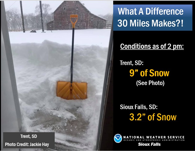
As of 2 pm Friday, around 9 inches of snow had been reported in Trent, South Dakota. Roughly 30 miles south, at the Sioux Falls Airport, only 3.2 inches snow had fallen through that time.
 |
Media use of NWS Web News Stories is encouraged! Please acknowledge the NWS as the source of any news information accessed from this site. |
|


 Weather Story
 Weather Map
 Local Radar